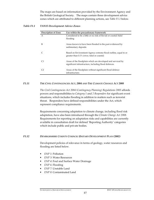
- Page 1 and 2: Annex F Geology and Hydrology • F
- Page 3 and 4: F1 WATER RESOURCES AND FLOODING - L
- Page 5 and 6: After the GQA has been conducted, a
- Page 7: Protection Zones (SPZs) across Engl
- Page 11 and 12: CONTENTS 1 INTRODUCTION 1 2 ASSESSM
- Page 13 and 14: 2 ASSESSMENT METHODOLOGY 2.1 INTROD
- Page 15 and 16: • Each peat probing location was
- Page 17 and 18: 3 RESULTS 3.1 DESK STUDY RESULTS 3.
- Page 19 and 20: lower horizon. From these soil seri
- Page 21 and 22: Figure 3.3 Wilcocks 2 Comprising So
- Page 23 and 24: y their peat-forming vegetation). I
- Page 25 and 26: Table 3.2 Peat survey results at pr
- Page 27 and 28: BGS superfiical Phase 1 Turbine NSR
- Page 29 and 30: BGS superfiical deposits and underl
- Page 31 and 32: Table 3.3 Existing and new access t
- Page 33 and 34: 3.2.4 Peat Loss Calculations Direct
- Page 35 and 36: Infrastructure component Access tra
- Page 37 and 38: 4 RECOMMENDED MITIGATION MEASURES 4
- Page 39 and 40: Appendix 1 CCW Consultation
- Page 41 and 42: CCW are of the view that the impact
- Page 43 and 44: Undertaking'. Within this document
- Page 45 and 46: Section 42 and LBAP Species/Habitat
- Page 47 and 48: We recommend the inclusion of detai
- Page 49 and 50: APPENDIX 1: EUROPEAN PROTECTED SPEC
- Page 51 and 52: CADEIRYDD/CHAIRMAN: JOHN LLOYD JONE
- Page 53 and 54: Peat depth Peat depth is some refec
- Page 55 and 56: Annexe 1: 1.1 Overview (limited ext
- Page 57 and 58: Yours sincerely Name Title Enc cc.
- Page 59 and 60:
It would be useful to define what i
- Page 61 and 62:
• If peat is identified through d
- Page 63 and 64:
1 PHOTOLOG OF SURVEY LOCATIONS Figu
- Page 65 and 66:
Figure 1.5 Turbine 4 Figure 1.6 Tra
- Page 67 and 68:
Figure 1.9 Track past Turbine 7 Fig
- Page 69 and 70:
Figure 1.13 Turbine 11 - Dense fore
- Page 71 and 72:
Figure 1.17 Turbine 13 Figure 1.18
- Page 73 and 74:
Figure 1.21 Turbine 19 Figure 1.22
- Page 75 and 76:
Figure 1.25 Track past Turbine 25 F
- Page 77 and 78:
Appendix 3 Detailed Results Figures
- Page 79 and 80:
KEY: 0.15m 0.08m 0.2m 0.28m 0.18m 0
- Page 81 and 82:
KEY: Development Area Turbine Sampl
- Page 83 and 84:
KEY: TURBINE 4 Development Area Tur
- Page 85 and 86:
KEY: TURBINE 7 Development Area Tur
- Page 87 and 88:
KEY: TURBINE 9 Development Area Tur
- Page 89 and 90:
KEY: Development Area Turbine Sampl
- Page 91 and 92:
KEY: TURBINE 22 Development Area Tu
- Page 93 and 94:
KEY: TURBINE 26 Development Area Tu
- Page 95 and 96:
KEY: 0.2 0.12 Development Area Turb
- Page 97 and 98:
National Soil Resources Institute S
- Page 99 and 100:
National Soil Resources Institute A
- Page 101 and 102:
National Soil Resources Institute W
- Page 103 and 104:
National Soil Resources Institute 1
- Page 105 and 106:
National Soil Resources Institute 1
- Page 107 and 108:
National Soil Resources Institute 1
- Page 109 and 110:
National Soil Resources Institute 1
- Page 111 and 112:
National Soil Resources Institute 1
- Page 113 and 114:
National Soil Resources Institute 1
- Page 115 and 116:
National Soil Resources Institute 1
- Page 117 and 118:
National Soil Resources Institute 1
- Page 119 and 120:
National Soil Resources Institute M
- Page 121 and 122:
National Soil Resources Institute M
- Page 123 and 124:
National Soil Resources Institute M
- Page 125 and 126:
National Soil Resources Institute M
- Page 127 and 128:
National Soil Resources Institute P
- Page 129 and 130:
National Soil Resources Institute P
- Page 131 and 132:
National Soil Resources Institute P
- Page 133 and 134:
National Soil Resources Institute a
- Page 135 and 136:
National Soil Resources Institute B
- Page 137 and 138:
National Soil Resources Institute e
- Page 139 and 140:
National Soil Resources Institute e
- Page 141 and 142:
National Soil Resources Institute W
- Page 143 and 144:
National Soil Resources Institute W
- Page 145 and 146:
National Soil Resources Institute W
- Page 147 and 148:
National Soil Resources Institute 3
- Page 149 and 150:
National Soil Resources Institute 3
- Page 151 and 152:
National Soil Resources Institute S
- Page 153 and 154:
National Soil Resources Institute A
- Page 155 and 156:
National Soil Resources Institute S
- Page 157 and 158:
National Soil Resources Institute A
- Page 159 and 160:
National Soil Resources Institute W
- Page 161 and 162:
National Soil Resources Institute 1
- Page 163 and 164:
National Soil Resources Institute 1
- Page 165 and 166:
National Soil Resources Institute 1
- Page 167 and 168:
National Soil Resources Institute 1
- Page 169 and 170:
National Soil Resources Institute 1
- Page 171 and 172:
National Soil Resources Institute 1
- Page 173 and 174:
National Soil Resources Institute 1
- Page 175 and 176:
National Soil Resources Institute 1
- Page 177 and 178:
National Soil Resources Institute M
- Page 179 and 180:
National Soil Resources Institute M
- Page 181 and 182:
National Soil Resources Institute M
- Page 183 and 184:
National Soil Resources Institute M
- Page 185 and 186:
National Soil Resources Institute P
- Page 187 and 188:
National Soil Resources Institute P
- Page 189 and 190:
National Soil Resources Institute P
- Page 191 and 192:
National Soil Resources Institute a
- Page 193 and 194:
National Soil Resources Institute B
- Page 195 and 196:
National Soil Resources Institute e
- Page 197 and 198:
National Soil Resources Institute e
- Page 199 and 200:
National Soil Resources Institute W
- Page 201 and 202:
National Soil Resources Institute W
- Page 203 and 204:
National Soil Resources Institute W
- Page 205 and 206:
National Soil Resources Institute 3
- Page 207 and 208:
National Soil Resources Institute 3
- Page 209 and 210:
National Soil Resources Institute S
- Page 211 and 212:
National Soil Resources Institute A
- Page 213 and 214:
Annex F4 Flood Consequences Assessm
- Page 215 and 216:
Flood Consequences Assessment - Clo
- Page 217 and 218:
Contents Executive Summary ........
- Page 219 and 220:
1 Introduction 1.1 Objectives Walli
- Page 221 and 222:
Runoff rates under 100-year storm t
- Page 223 and 224:
2 Description of the Site 2.1 Backg
- Page 225 and 226:
Steep channel with forest debris cl
- Page 227 and 228:
Figure 3 Location of proposed turbi
- Page 229 and 230:
2.4 Catchment Delineation An assess
- Page 231 and 232:
Outfall grid reference Total catchm
- Page 233 and 234:
Tests were attempted at two sites w
- Page 235 and 236:
The long term impacts on the surfac
- Page 238 and 239:
4 Flood Consequences Assessment 4.1
- Page 240 and 241:
4.3 Current Flood Risk In summary,
- Page 242 and 243:
Analyses are not presented for the
- Page 244 and 245:
WRAP fractional extents of 0.75 WRA
- Page 246 and 247:
5.3 Calculation of Existing Greenfi
- Page 248 and 249:
Afon Alwen No. 3 Afon Alwen No. 4 R
- Page 250 and 251:
1. Do nothing - on the grounds that
- Page 252 and 253:
5.6 Construction Appropriate method
- Page 254 and 255:
On the basis of a literature review
- Page 256 and 257:
Robinson, M. and Dupeyrat, A. 2005.
- Page 258 and 259:
Clocaenog Methodology and reasons f
- Page 260 and 261:
Clocaenog Methodology for mineral s
- Page 262 and 263:
Clocaenog Methodology for mineral s
- Page 264 and 265:
1.1 OVERVIEW CLOCEANOG WIND FARM BO
- Page 266 and 267:
Table1.1 Forest and Water Guideline
- Page 268 and 269:
Table 1.2 Borrow pit search areas S
- Page 270 and 271:
Table 1.3 Recommended borrow pit lo
- Page 272 and 273:
Name Easting Northing Search Area N
- Page 274:
360000 .000000 359000 .000000 35800


