F. Geology & Hydrology ( PDF | 31.0 MB ) - RWE.com
F. Geology & Hydrology ( PDF | 31.0 MB ) - RWE.com
F. Geology & Hydrology ( PDF | 31.0 MB ) - RWE.com

You also want an ePaper? Increase the reach of your titles
YUMPU automatically turns print PDFs into web optimized ePapers that Google loves.
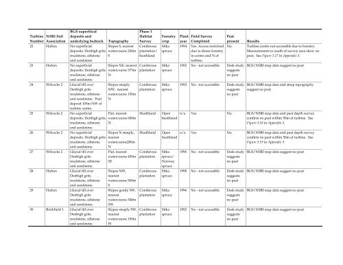
BGS superfiical<br />
Phase 1<br />
Turbine NSRI Soil deposits and<br />
Habitat Forestry Plant Field Survey Peat<br />
Number Association underlying bedrock Topography Survey crop year Completed present Results<br />
22 Hafren No superficial Slopes S, nearest Coniferous Sitka 1994 Yes. Access restricted No Turbine centre not accessible due to forestry.<br />
deposits. Denbigh grits watercourse 200m plantation/ spruce<br />
due to dense forestry<br />
Measurements to south of survey area show no<br />
mudstone, siltstone S<br />
heathland<br />
in centre and N of<br />
peat. See Figure 3.17 in Appendix 3.<br />
and sandstone<br />
turbine.<br />
23 Hafren No superficial Slopes NE, nearest Coniferous Sitka 1992 No - not accessible Desk study BGS/NSRI map data suggest no peat<br />
deposits. Denbigh grits watercourse 375m plantation spruce<br />
suggests<br />
mudstone, siltstone<br />
and sandstone<br />
N<br />
no peat<br />
24 Wilcocks 2 Glacial till over Slopes steeply Coniferous Sitka 1993 No - not accessible Desk study BGS/NSRI map data and steep topography<br />
Denbigh grits NW, nearest plantation spruce<br />
suggests suggest no peat<br />
mudstone, siltstone watercourse 150m<br />
no peat<br />
and sandstone. Peat<br />
deposit 105m NW of<br />
turbine centre.<br />
N<br />
25 Wilcocks 2 No superficial Flat, nearest Heathland Open n/a Yes No BGS/NSRI map data and peat depth survey<br />
deposits. Denbigh grits watercourse 600m<br />
heathland<br />
confirm no peat within 50m of turbine. See<br />
mudstone, siltstone<br />
and sandstone<br />
N<br />
Figure 3.18 in Appendix 3.<br />
26 Wilcocks 2 No superficial Slopes N steeply, Heathland Open n/a Yes No BGS/NSRI map data and peat depth survey<br />
deposits. Denbigh grits nearest<br />
heathland<br />
confirm no peat within 50m of turbine. See<br />
mudstone, siltstone watercourse280m<br />
Figure 3.19 in Appendix 3.<br />
and sandstone N<br />
27 Wilcocks 2 Glacial till over Flat, nearest Coniferous Sitka 1996 No - not accessible Desk study BGS/NSRI map data suggest no peat<br />
Denbigh grits watercourse 430m plantation spruce/<br />
suggests<br />
mudstone, siltstone SE<br />
Norway<br />
no peat<br />
and sandstone.<br />
spruce<br />
28 Hafren Glacial till over Slopes NW, Coniferous Sitka 1998 No - not accessible Desk study BGS/NSRI map data suggest no peat<br />
Denbigh grits nearest<br />
plantation spruce<br />
suggests<br />
mudstone, siltstone watercourse 500m<br />
no peat<br />
and sandstone. S<br />
29 Hafren Glacial till over Slopes gently SW, Coniferous Sitka 1996 No - not accessible Desk study BGS/NSRI map data suggest no peat<br />
Denbigh grits nearest<br />
plantation spruce<br />
suggests<br />
mudstone, siltstone watercourse 340m<br />
no peat<br />
and sandstone. SW<br />
30 Brickfield 1 Glacial till over<br />
Denbigh grits<br />
mudstone, siltstone<br />
and sandstone.<br />
Slopes steeply SW,<br />
nearest<br />
watercourse 150m<br />
W<br />
Coniferous<br />
plantation<br />
Sitka<br />
spruce<br />
1992 No - not accessible Desk study<br />
suggests<br />
no peat<br />
BGS/NSRI map data suggest no peat