Oman Dam Safety, Oman
Oman Dam Safety, Oman
Oman Dam Safety, Oman

Create successful ePaper yourself
Turn your PDF publications into a flip-book with our unique Google optimized e-Paper software.
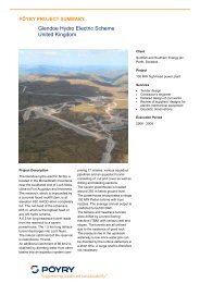
PÖYRY PROJECT SUMMARY<br />
Project Description<br />
Consulting services for the safety evaluation of existing<br />
recharge dams<br />
Sultanate of <strong>Oman</strong><br />
The Ministry of Regional<br />
Municipalities, Environment and<br />
Water Resources (MRMEWR)<br />
required safety evaluations of seven<br />
existing recharge dams built between<br />
1985 and 1992 in the Sultanate of<br />
<strong>Oman</strong>. The objective of the study was<br />
to evaluate the condition of each of<br />
the dams and to assess their compliance<br />
with public safety requirements.<br />
The <strong>Safety</strong> Evaluation of Existing<br />
<strong>Dam</strong>s (SEED) procedure was used to<br />
determine the condition of each dam<br />
with respect to its structural and<br />
operating integrity. This procedure<br />
identifies any existing or potential<br />
safety deficiencies and confirms them<br />
by analyzing existing or developed<br />
data.<br />
Any engineering and geological<br />
deficiencies identified from the site<br />
inspection and/or from other sources<br />
are entered into a database and<br />
classed according to their degree of<br />
seriousness. The measures analysed<br />
covered the full range of issues that<br />
normally apply to dams and included,<br />
typically, hydrology and sedimentation,<br />
hydraulics, seismo-tectonic risk,<br />
geological, geotechnical and<br />
structural issues, as well as the<br />
required monitoring and maintenance<br />
works. The analyses were made using<br />
state-of-the-art techniques and<br />
methods available amongst all<br />
relevant disciplines, and were carried<br />
out in the following two phases:<br />
Client<br />
Ministry of Regional Municipalities,<br />
Environment and Water Resources<br />
(MRMEWR), Sultanate of <strong>Oman</strong><br />
Project<br />
Evaluation of the present condition of<br />
seven existing flood protection and<br />
ground water recharge dams.<br />
Services<br />
� Detailed inspection of the dams to<br />
determine their present condition<br />
� Review and analysis of geology,<br />
hydrology and hydraulic data<br />
� Tendering of sub-contracts for in<br />
situ and laboratory testing<br />
� Supervision of site investigation<br />
works and laboratory testing<br />
� Structural (stability) analyses<br />
� Definition of remedial works<br />
� Cost-benefit analysis of proposed<br />
remedial measures<br />
Execution Period<br />
2005 – 2007<br />
Phase 1 (inspection and examination)<br />
was a technical assessment based on<br />
all available data from site inspections<br />
and reports on the dams. If the results<br />
of this phase were inconclusive, a<br />
Phase 2 study (investigation and<br />
analysis) was required. This was a<br />
more detailed study and included the<br />
special field investigations and<br />
laboratory tests needed to establish<br />
the necessary design parameters for<br />
the more sophisticated analyses of<br />
the dams and their related structures.
Depth [m]<br />
Sultanate of <strong>Oman</strong>: consulting services for safety evaluation of existing recharge dams,<br />
Key data<br />
Name of dam<br />
0.00<br />
0.20<br />
0.40<br />
0.60<br />
0.80<br />
1.00<br />
1.20<br />
1.40<br />
1.60<br />
1.80<br />
2.00<br />
Gypsum vs. Depth<br />
Gypsum content [%]<br />
0 5 10 15 20 25 30<br />
TR-1<br />
5<br />
2<br />
TR-2<br />
7<br />
Type of<br />
structure<br />
5<br />
2 D2<br />
7<br />
Completion<br />
year<br />
TR-2<br />
8 8<br />
Max. height<br />
of dam<br />
TR-1<br />
8<br />
TR-1<br />
Total length<br />
of dam<br />
Max. storage<br />
volume<br />
Capacity of<br />
spillway<br />
Wadi Al Jizi Zoned embankment 1989 20.40 m 1'234 m 0.66 Mm 3 7'800 m 3 /s<br />
Wadi Al Khoud Zoned embankment 1985 11.00 m 5'100 m 11.60 Mm 3 12'500 m 3 /s<br />
Wadi Fulaij (H) Zoned embankment 1992 7.70 m 3'346 m 3.70 Mm 3 2'200 m 3 /s<br />
Wadi Ghul Gabion cascade weir 1989 7.60 m 415 m 0.09 Mm 3 2'800 m 3 /s<br />
Wadi Khasab Zoned embankment 1986 23.00 m 830 m 16.00 Mm 3 1'000 m 3 /s<br />
Wadi Shariya Zoned embankment 1986 9.20 m 740 m 1.50 Mm 3 400 m 3 /s<br />
Wadi Mawa Zoned embankment 1986 8.00 m 820 m 1.40 Mm 3 350 m 3 /s<br />
<strong>Dam</strong>s covered by study with main characteristics.<br />
Seepage along downstream toe of the right wing embankment of<br />
Wadi Fulaij (Halban) dam following heavy rain and impounding in<br />
February 2006.<br />
Evaluation of laboratory tests: distribution of gypsum with depth (the numbers<br />
refer to the number of the trial pit or trench from which samples were obtained).<br />
In situ investigation works at Wadi Fualij (Halban) dam; drilling in<br />
reservoir area to locate possible seepage zones in gypsum.