enhancing biodiversity hotspots along western ... - South West NRM
enhancing biodiversity hotspots along western ... - South West NRM
enhancing biodiversity hotspots along western ... - South West NRM

You also want an ePaper? Increase the reach of your titles
YUMPU automatically turns print PDFs into web optimized ePapers that Google loves.
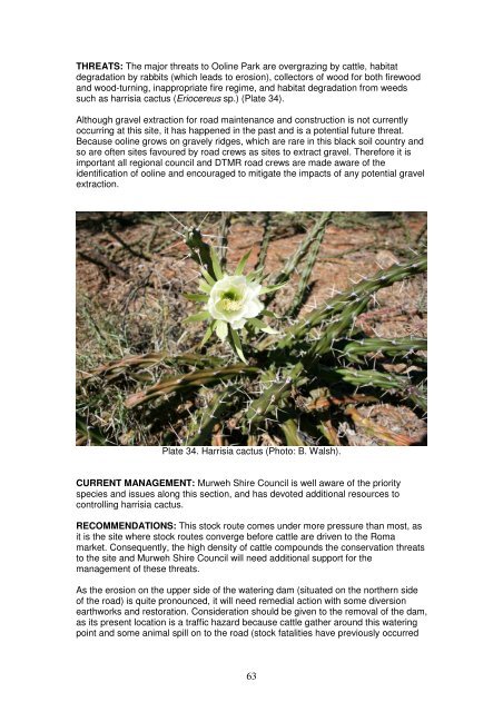
THREATS: The major threats to Ooline Park are overgrazing by cattle, habitat<br />
degradation by rabbits (which leads to erosion), collectors of wood for both firewood<br />
and wood-turning, inappropriate fire regime, and habitat degradation from weeds<br />
such as harrisia cactus (Eriocereus sp.) (Plate 34).<br />
Although gravel extraction for road maintenance and construction is not currently<br />
occurring at this site, it has happened in the past and is a potential future threat.<br />
Because ooline grows on gravely ridges, which are rare in this black soil country and<br />
so are often sites favoured by road crews as sites to extract gravel. Therefore it is<br />
important all regional council and DTMR road crews are made aware of the<br />
identification of ooline and encouraged to mitigate the impacts of any potential gravel<br />
extraction.<br />
Plate 34. Harrisia cactus (Photo: B. Walsh).<br />
CURRENT MANAGEMENT: Murweh Shire Council is well aware of the priority<br />
species and issues <strong>along</strong> this section, and has devoted additional resources to<br />
controlling harrisia cactus.<br />
RECOMMENDATIONS: This stock route comes under more pressure than most, as<br />
it is the site where stock routes converge before cattle are driven to the Roma<br />
market. Consequently, the high density of cattle compounds the conservation threats<br />
to the site and Murweh Shire Council will need additional support for the<br />
management of these threats.<br />
As the erosion on the upper side of the watering dam (situated on the northern side<br />
of the road) is quite pronounced, it will need remedial action with some diversion<br />
earthworks and restoration. Consideration should be given to the removal of the dam,<br />
as its present location is a traffic hazard because cattle gather around this watering<br />
point and some animal spill on to the road (stock fatalities have previously occurred<br />
63
here), and if a new watering point was established further towards Mitchell this<br />
difference in distance would not disadvantage drovers.<br />
It is also recommended that there should be no camping of stock overnight in the<br />
vicinity and stock should be expedited through the park. This would not<br />
inconvenience drovers either as there is minimal stock feed at this site. Designated<br />
overnight camping zones would prevent overgrazing of priority species, or trampling<br />
of the habitat of another priority species – the collared delma (Delma torquata).<br />
Consideration should be given to develop a comprehensive zoned management plan<br />
<strong>along</strong> the Morven to Mitchell section of stock route P002, as there are five priority<br />
species (ooline, womal (Acacia maranoensis), painted honeyeater (Grantiella picta),<br />
collared delma (Delma torquata), and diamond firetail (Stagonopleura guttata)) and<br />
three identified <strong>biodiversity</strong> <strong>hotspots</strong> <strong>along</strong> this route that are currently being<br />
considered in isolation. Management of specific sites may need to include some<br />
fencing of ooline and womal (Acacia maranoensis) in the more vulnerable locations.<br />
64
Site 4. Morven – Tregole Road (opposite Tregole Park)<br />
STOCK ROUTE NUMBER: U527<br />
PRIORITY SPECIES: Plants:<br />
ooline (Cadellia pentasylis).<br />
RATING: BIODIVERSITY HOTSPOT<br />
SHIRE COUNCIL: MURWEH SHIRE<br />
This site is a triangular reserve on an inactive stock route opposite Tregole National<br />
Park. It is one of the best stands of ooline (Cadellia pentasylis) (Plate 35) visited<br />
during the field visits for this project, as the trees were abundant and intermixed with<br />
bottle trees (Brachychiton rupestris). This reserve is approximately 300 metres by<br />
100 metres, and as it is opposite Tregole National Park it has good connectivity. The<br />
site also has a road on all sides that provides good protection from wildfires.<br />
Plate 35. Ooline trees (Photo: B. Walsh).<br />
THREATS: The major threats to this reserve are overgrazing by cattle, habitat<br />
degradation by rabbits, inappropriate fire regime, collectors (for both firewood and<br />
wood turning), and habitat degradation by weeds.<br />
CURRENT MANEGEMENT: None.<br />
RECOMMENDATIONS: It is recommended that there needs to be negotiations<br />
between Murweh Shire Council and DTMR to recognise this site as an area of ‘no<br />
disturbance’, which would avoid accidental clearance or gravel extraction. Inclusion<br />
of the site in the shire pest and weed management programme is also<br />
recommended.<br />
65
Site 5. Mungalala – Mitchell Road (1) (Warrego Highway)<br />
STOCK ROUTE NUMBER: P002<br />
PRIORITY SPECIES: Plants:<br />
ooline (Cadellia pentasylis).<br />
RATING: BIODIVERSITY HOTSPOT<br />
SHIRE COUNCIL: MURWEH SHIRE<br />
Although the ooline trees (Cadellia pentasylis) at this site are scattered <strong>along</strong> either<br />
side of the highway, they do however consist of both mature and regenerating trees,<br />
and so the site is valuable as a <strong>biodiversity</strong> hotspot.<br />
THREATS: The major threats to this site are overgrazing by cattle, habitat<br />
degradation by rabbits, wood collectors, inappropriate fire regime, gravel extraction,<br />
road widening, and habitat degradation by weeds.<br />
CURRENT MANAGEMENT: None. Although <strong>along</strong> the nearby section of the<br />
Warrego Highway there is work being undertaken by Murweh Shire Council to<br />
address weeds, especially harrisia cactus (Eriocereus sp.), which is part of the weed<br />
control for Ooline Park (site 3, pp. 62-64).<br />
RECOMMENDATIONS: As for Ooline Park, it is recommended that there needs to<br />
be negotiations between Murweh Shire Council and DTMR to recognise this site as<br />
an area of ‘no disturbance’, which would avoid accidental clearance or gravel<br />
extraction. Inclusion of the site in the shire pest and weed management programme<br />
is also recommended.<br />
66
Site 6. Mungalala – Mitchell Road (2) (Warrego Highway)<br />
STOCK ROUTE NUMBER: P002<br />
PRIORITY SPECIES: Plants:<br />
womal (Acacia maranoensis).<br />
Animals:<br />
painted honeyeater (Grantiella picta).<br />
RATING: BIODIVERSITY HOTSPOT<br />
SHIRE COUNCIL: MURWEH SHIRE<br />
At this site womal (Acacia maranoensis) is spread <strong>along</strong> the sides of the Warrego<br />
Highway, where it is more abundant than ooline and widely spread about the district<br />
as well. Growing off the womal trees is grey mistletoe (Amyema quandang), which is<br />
a favourite of the painted honeyeater (Grantiella picta) – another priority species<br />
which has been sighted in this location. There is actually an overlap with ooline <strong>along</strong><br />
the Warrego Highway, resulting in five priority species in one extended stretch of<br />
highway (womal, ooline, painted honeyeater, collared delma (Delma torquata), and<br />
diamond firetail (Stagonopleura guttata)).<br />
THREATS: The major threats to this site are overgrazing and disturbance (Plate 36)<br />
by cattle, habitat degradation by rabbits, inappropriate fire regime, and habitat<br />
degradation by weeds.<br />
Plate 36. Overnight cattle stock camp after rain (Photo: B. Walsh).<br />
CURRENT MANAGEMENT: Murweh Shire Council concentrates on this length of<br />
stock route for weed management.<br />
67
RECOMMENDATIONS: It is recommended that Murweh Shire Council maintain their<br />
weed management <strong>along</strong> this length of stock route, and that this be included in a<br />
management plan for all the <strong>biodiversity</strong> <strong>hotspots</strong> <strong>along</strong> this stock route (as<br />
mentioned under site 3, Ooline Park). Permits given for the movement of stock <strong>along</strong><br />
this route need to emphasise that overnight camping of stock should avoid these<br />
sites where possible, as womal is quite palatable to stock and the regenerating plants<br />
at this site could easily be consumed by cattle.<br />
68
Site 7. Morven – Tregonning Road<br />
STOCK ROUTE NUMBER: M570<br />
PRIORITY SPECIES: Plants:<br />
womal (Acacia maranoensis).<br />
RATING: BIODIVERSITY HOTSPOT<br />
SHIRE COUNCIL: MURWEH SHIRE<br />
This site is on a back road that is rated as an active stock route, but as with many of<br />
these sites it is virtually inactive. The womal trees (Acacia maranoensis) at this site<br />
are scattered over a wide area (Plate 37), but consist of both mature and<br />
regenerating trees. Additionally, there was good connectivity with habitat on adjoining<br />
private land.<br />
Plate 37. Womal (Photo: B. Walsh).<br />
THREATS: The major threats to this site are overgrazing by cattle, habitat<br />
degradation by rabbits, inappropriate fire regime, gravel extraction, and habitat<br />
degradation by weeds. There is also a borrow pit in the middle of a mature stand of<br />
trees.<br />
CURRENT MANAGEMENT: None.<br />
RECOMMENDATIONS: It is recommended that the borrow pit be phased out as<br />
further expansion of the pit will cause more trees to be removed.<br />
Some priority species, such as womal in this area, are often locally common, and it is<br />
recommended that awareness programmes for field-based council staff would be<br />
useful to raise awareness of the value of these species as well as their management<br />
needs.<br />
69
Site 8. Bundoona Springs (Eulo – Toompine Road)<br />
STOCK ROUTE NUMBER: U512<br />
PRIORITY SPECIES: Plants:<br />
Hydrocotyle dipleura, and<br />
Myriophyllum artesium.<br />
RATING: BIODIVERSITY HOTSPOT<br />
SHIRE COUNCIL: PAROO SHIRE<br />
This spring is located in open mulga country adjacent to a drainage line on the stock<br />
route (Plate 38), and is one of the group that makes up Bundoona Springs. It is a<br />
large, shallow and vegetated spring, which is well known as it has long been studied<br />
for its endemic species.<br />
Plate 38. Bundoona Springs (Photo: B. Walsh).<br />
THREATS: The major threats to this spring are reduced flow and habitat degradation<br />
from water draw-down, overgrazing and trampling by cattle, rooting and wallowing<br />
damage by feral pigs, competition between introduced Gambusia fish and native<br />
aquatic fauna, and habitat degradation by weeds.<br />
CURRENT MANAGEMENT: None.<br />
RECOMMENDATIONS: It is acknowledged that all springs are not the same, and<br />
best practice management may vary from spring to spring. It must also be<br />
acknowledged that these springs existed with their endemic species before the<br />
arrival of Europeans, livestock and invasive species such as feral animals and<br />
weeds.<br />
Inadequate information exists to make recommendations on best practice<br />
management for this spring. However, it is recommended that an enclosure be<br />
70
established on part of the spring to study the effects of excluding cattle and feral pigs.<br />
The results from this enclosure would give a benchmark from which to monitor the<br />
impacts of cattle and pigs that might occur at this spring. This recommendation is<br />
based on the success of excluding cattle and pigs at Tego spring in Culgoa<br />
Floodplains National Park (page 98) that resulted in the return of plant species<br />
including the Rare Sporobolus partimpatens (Craig Eddy, pers. comm.). Similarly the<br />
condition of Elizabeth Springs in the Desert Channels <strong>NRM</strong> region has improved<br />
markedly with the use of fencing to exclude cattle (Steve Wilson, pers. comm.).<br />
At the time of this project, negotiations were being undertaken with the adjoining<br />
owners to make the springs a nature refuge. If this proceeds, it is recommended that<br />
this spring be included in that nature refuge.<br />
71
Site 9. Currawinya National Park (Stock Route)<br />
STOCK ROUTE NUMBER: U510<br />
PRIORITY SPECIES: Animals:<br />
painted honeyeater (Grantiella picta).<br />
RATING: BIODIVERSITY HOTSPOT<br />
SHIRE COUNCIL: BULLOO SHIRE<br />
The stock route that runs through Currawinya National Park is narrow, unused, and<br />
the connectivity is continuous. Painted honeyeaters (Grantiella picta) are regularly<br />
sighted <strong>along</strong> the route and feed on the mistletoe Amyema quandang (Plate 39),<br />
which grows prolifically on the mulga trees.<br />
Plate 39. The mistletoe Amyema quandang (Photo: B. Walsh).<br />
THREATS: The major threats to this site are browsing by goats (that can prevent<br />
regeneration of mulga on which the mistletoe Amyema quandang grows), and<br />
predation of native fauna by feral cats. Inappropriate fire regime is a potential threat.<br />
It is possible that apiary activities outside the park may be competing with the painted<br />
honeyeaters for nectar as a food source.<br />
CURRENT MANAGEMENT: This stock route comes under the management of<br />
Currawinya National Park.<br />
72
RECOMMENDATIONS: It is recommended that DERM’s current management<br />
activities be maintained, and that the site would benefit from a more coordinated<br />
approach to pest management between Bulloo Shire Council and DERM.<br />
At the time of the project, surveys were being undertaken by Birds Australia Birdata<br />
in the southern part of the <strong>South</strong> <strong>West</strong> <strong>NRM</strong> region. An opportunity may exist from<br />
the results of this survey to identify additional sites for the painted honeyeater.<br />
73
Site 10. Lake Bindegolly (Eulo – Thargomindah Road)<br />
STOCK ROUTE NUMBER: U508<br />
PRIORITY SPECIES: Animals:<br />
Australasian bittern (Botaurus poiciloptilus),<br />
Australian painted snipe (Rostratula australis), and<br />
painted honeyeater (Grantiella picta).<br />
RATING: BIODIVERSITY HOTSPOT<br />
SHIRE COUNCIL: BULLOO SHIRE<br />
Lake Bindegolly (Plate 40) is a string of salt and freshwater wetlands in Lake<br />
Bindegolly National Park that dries out approximately every decade. The lakes are a<br />
major haven for waterbirds including the priority species Australasian bittern<br />
(Botaurus poiciloptilus), Australian painted snipe (Rostratula australis) and painted<br />
honeyeater (Grantiella picta), and other species of interest such as the Rare freckled<br />
duck (Stictonetta naevosa) and the Vulnerable plant Acacia ammophila.<br />
The stock route cuts the system in half, but the stock route is inactive. A tourist<br />
information bay has been established as the area is popular with tourists, and use of<br />
the stock routes for tourism is well supported by the Bulloo Shire Council.<br />
Plate 40. Lake Bindegolly with an approaching storm in the distance<br />
(Photo: B. Walsh).<br />
THREATS: The major threats to Lake Bindegolly are predation by feral cats, foxes<br />
and dogs, habitat degradation by rabbits, weeds, feral pigs and feral goats, and<br />
overgrazing by livestock (both sheep and cattle).<br />
CURRENT MANAGEMENT: Lake Bindegolly comes under the management of Lake<br />
Bindegolly National Park.<br />
74
RECOMMENDATIONS: It is recommended that DERM’s current management<br />
activities be maintained, and that wherever possible pest and weed control be<br />
coordinated with those of the Bulloo Shire Council. It is also suggested that<br />
consideration be given to the installation of cattle grids <strong>along</strong> the main road to<br />
prevent the continuous drifting of livestock into the national park.<br />
75
Site 11. Ward River (Charleville – Quilpie Road)<br />
STOCK ROUTE NUMBER: M507<br />
PRIORITY SPECIES: Animals:<br />
Murray cod (Maccullochella peelii peelii).<br />
RATING: BIODIVERSITY HOTSPOT<br />
SHIRE COUNCIL: MURWEH SHIRE<br />
The Ward River waterhole and adjacent reserve is a favourite recreational site for the<br />
people of Charleville. The Charleville Fishing and Restocking Club (CFRC) in<br />
conjunction with the DEEDI, are also active at this site with a catch and release<br />
programme for Murray cod (Maccullochella peelii peelii) (Plates 41 and 42), and<br />
undertake restocking of the cod at well known waterholes.<br />
Due to the ephemeral nature of all rivers and creeks in <strong>western</strong> Queensland, fish<br />
stocks tend to retreat to these known refugia in the dry times to await the next wet<br />
season and flooding event. The river at this site on Ward River is about seven metres<br />
deep at the bridge, and averages about four metres in depth across the waterhole.<br />
Such waterholes of this depth and dimension are not common and are extremely<br />
important to all species they support, especially Murray cod.<br />
Plate 41. A juvenile Murray cod (Photo: G. Walsh).<br />
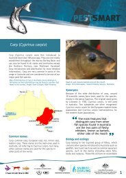
76
THREATS: The major threats to this site on the Ward River are overgrazing of the<br />
riparian edge by cattle, overfishing, introduced carp (Cyprinus carpio) that can<br />
compete with and displace Murray cod, habitat degradation from water extraction,<br />
and erosion where visitors drive off the access road. The removal of snags, which<br />
removes an important feature of the habitat for Murray cod, is a potential threat.<br />
CURRENT MANAGEMENT: Murweh Shire Council maintains road access off the<br />
main highway to the river bank. The CFRC maintain an informal recreational<br />
monitoring, restocking and catch and release programme for Murray cod.<br />
RECOMMENDATIONS: It is important to support and maintain the current actions to<br />
conserve Murray cod that are undertaken by the CFRC and DEEDI.<br />
It would be highly beneficial to control carp in this waterhole, as has been planned by<br />
<strong>South</strong> <strong>West</strong> <strong>NRM</strong> who are attempting to initiate carp management projects in the<br />
Warrego River and its tributaries such as the Ward River.<br />
Droving permits should stipulate no overnight camping of stock on the Ward River in<br />
order to avoid siltation and deterioration of water quality. Static grazing of this stock<br />
route reserve should be declined or limited in the interests of public usage and the<br />
avoidance of siltation.<br />
Similarly to other locations in <strong>western</strong> Queensland, this site is reaching the point<br />
where the local council will need to consider a management plan to address visitor<br />
impacts from camping, pollution, rubbish, and firewood collection.<br />
Plate 42. The CFRC releasing Murray cod fingerlings (Photo: D. Clark).<br />
77
Site 12. Bakers Bend (Warrego River)<br />
STOCK ROUTE NUMBER: P052<br />
PRIORITY SPECIES: Animals:<br />
Murray cod (Maccullochella peelii peelii).<br />
RATING: BIODIVERSITY HOTSPOT<br />
SHIRE COUNCIL: MURWEH SHIRE<br />
Bakers Bend is one of the largest waterholes on the Warrego River, and a popular<br />
local and tourist destination. This is major refugia for aquatic species, such as Murray<br />
cod (Maccullochella peelii peelii), and averages about six metres deep. The stock<br />
route runs on both sides of the river, and is classified as active but has not been used<br />
for some years. The riparian vegetation is mostly healthy, old growth trees, with the<br />
exception of some eroded sites, and is a known habitat for koala (Phascolarctos<br />
cinereus) and sugar glider (Petaurus breviceps).<br />
THREATS: The major threats to Bakers Bend are overfishing, habitat degradation<br />
from water extraction, introduced carp (Cyprinus carpio) that can compete with and<br />
displace Murray cod, and siltation from erosion that is exacerbated by feral goats<br />
(Plate 43).<br />
Plate 43. Erosion at Bakers Bend (Photo: B. Walsh).<br />
CURRENT MANAGEMENT: The CFRC, under guidance from DEEDI, conduct<br />
recreational monitoring, restocking and catch and release for Murray cod (Plate 44).<br />
78
Plate 44. Tagging a mature Murray cod for release (Photo: D. Clark).<br />
RECOMMENDATIONS: The removal of goats from the badly eroded areas,<br />
combined with some earthworks/fencing, would greatly contribute to restore some of<br />
the damage to this site and reduce siltation of the river.<br />
As for the Ward River <strong>biodiversity</strong> hotspot (site 11, pp. 76-77), it would be highly<br />
beneficial to control carp at this waterhole, as has been planned by <strong>South</strong> <strong>West</strong> <strong>NRM</strong><br />
who are attempting to initiate carp management projects in the Warrego River and its<br />
tributaries.<br />
It is important to support and maintain the current actions to conserve Murray cod<br />
that are undertaken by the CFRC (with guidance from DEEDI).<br />
Recent fish surveys by DEEDI indicated that Bakers Bend has very little structure on<br />
the bottom of the river, which denies hatchling cod and other native species<br />
protective habitat. It is strongly recommended that consideration be given to the<br />
reintroduction of snags to improve the habitat of this aquatic refuge.<br />
Concern has been expressed by the CFRC and others that there is a decline in<br />
freshwater catfish (Tandanus tandanus) throughout the Warrego and Paroo River<br />
systems. It would be prudent to monitor the populations of this species and identify<br />
any causes of any decline, as it may have implications for other native species as<br />
well.<br />
79
Site 13. Dillalah Waterhole (Warrego River)<br />
STOCK ROUTE NUMBER: P052<br />
PRIORITY SPECIES: Animals:<br />
Murray cod (Maccullochella peelii peelii).<br />
RATING: BIODIVERSITY HOTSPOT<br />
SHIRE COUNCIL: MURWEH SHIRE<br />
The bridge at Dillalah crossing traverses another well known waterhole on the<br />
Warrego River for Murray cod (Maccullochella peelii peelii). This waterhole averages<br />
approximately five metres deep and has plenty of fallen trees and overhangs of tree<br />
roots that create good cod habitat. An active stock route runs down either side of the<br />
river, but the majority of stock traditionally travels down the eastern side. The riparian<br />
vegetation is in very good condition and is known to be a habitat for koala<br />
(Phascolarctos cinereus) (Plate 45).<br />
Plate 45. Koala at Boatman Station (Photo: N. Davies).<br />
THREATS: The major threats to this site are overgrazing by cattle that can affect the<br />
water quality, habitat degradation from pig rooting and wallowing, siltation from<br />
erosion, overfishing, and introduced carp (Cyprinus carpio) that can compete with<br />
and displace Murray cod. Water lettuce (Pistia stratiotes) (Plate 46) is an emerging<br />
threat that exists downstream at Cunnamulla, which has the potential to be<br />
transported upstream by wildlife.<br />
80
Plate 46. Water lettuce at Cunnamulla Weir (Photo: B. Walsh).<br />
CURRENT MANAGEMENT: Access to the site is maintained by Murweh Shire<br />
Council, and the monitoring of Murray cod is undertaken by CFRC and DEEDI.<br />
RECOMMENDATIONS: As for the Ward River <strong>biodiversity</strong> hotspot (site 11), it would<br />
be highly beneficial to control carp at this waterhole, as has been planned by <strong>South</strong><br />
<strong>West</strong> <strong>NRM</strong> who are attempting to initiate carp management projects in the Warrego<br />
River and its tributaries.<br />
It is important to support and maintain the current actions to conserve Murray cod<br />
that are undertaken by the CFRC (with guidance from DEEDI).<br />
Water lettuce occurs at the Cunnamulla Weir in Paroo Shire, where the Paroo Shire<br />
Council is taking action to eradicate this weed. However, biological control has not<br />
yet been introduced and should be considered and integrated with the current<br />
mechanical work being undertaken.<br />
The Cunnamulla Weir is an acknowledged fish barrier and careful consideration<br />
should be given to the installation of a suitable fish ladder, which is supported by the<br />
Paroo Shire Council. However, if implemented, care needs to be taken that it does<br />
not become a harvest site by default. <strong>South</strong> <strong>West</strong> <strong>NRM</strong> has previously proposed<br />
such a ladder for the Warrego and the Paroo Rivers (which has a similar barrier at<br />
Eulo).<br />
81
Site 14. Boatman Road (1) (Charleville – Bollon Road)<br />
STOCK ROUTE NUMBER: M528<br />
PRIORITY SPECIES: Animals:<br />
yakka skink (Egernia rugosa).<br />
RATING: BIODIVERSITY HOTSPOT<br />
SHIRE COUNCIL: MURWEH SHIRE<br />
There have been several sites <strong>along</strong> the Boatman Road which are <strong>biodiversity</strong><br />
<strong>hotspots</strong> for yakka skink (Egernia rugosa) (Plate 47). The sites look very<br />
inhospitable, and it is difficult to imagine there is enough insect life to sustain such a<br />
large skink.<br />
Confirmation of the sites was made with DERM expertise. Determination of presence<br />
and abundance was made from live trapping by DERM, which has given confidence<br />
in identification of the sites <strong>along</strong> the Boatman Road as suitable habitat.<br />
The yakka skink is mostly diurnal and very opportunistic. They make use of rabbit<br />
holes/warrens where they co-exist, as well as pushed-up roadside debris for habitat<br />
for sheltering and breeding. It usually constructs additional holes at the extremities of<br />
the warren for its usage.<br />
Plate 47. Yakka skink (Photo: B. Walsh).<br />
THREATS: The major threats to the yakka skink at this site are predation from feral<br />
cats, foxes and dogs, inappropriate fire regime, the destruction of the habitat by road<br />
works, and the destruction of the habitat if the rabbit warren are ripped up (if rabbit<br />
numbers rise and control is implemented).<br />
CURRENT MANAGEMENT: None.<br />
82
RECOMMENDATIONS: Yakka skinks are distributed over a vast area of<br />
Queensland, and to mitigate their threats will require the control of feral predators,<br />
appropriate fire regimes, and the protection of their habitat from road maintenance.<br />
As with other <strong>biodiversity</strong> <strong>hotspots</strong> <strong>along</strong> Boatman Road (sites 14 – 18, pp. 82-90),<br />
the priority actions at this site would be to include this location in the pest control<br />
activities for feral predators implemented by Murweh Shire Council, and to protect<br />
this habitat from any destructive impacts caused by any road works and rabbit<br />
control.<br />
For any future controlled fires at this site, it is recommended that they be of low<br />
intensity, and that any mounds of timber/plant material are unburnt as they are used<br />
as habitat by yakka skink.<br />
It is also strongly recommend that a population survey of yakka skinks be undertaken<br />
to map current populations, as isolated healthy populations may need more intensive<br />
protection.<br />
83
Site 15. Boatman Road (2) (Charleville – Bollon Road)<br />
STOCK ROUTE NUMBER: M528<br />
PRIORITY SPECIES: Animals:<br />
yakka skink (Egernia rugosa).<br />
RATING: BIODIVERSITY HOTSPOT<br />
SHIRE COUNCIL: MURWEH SHIRE<br />
As with other <strong>biodiversity</strong> <strong>hotspots</strong> <strong>along</strong> Boatman Road (sites 14 – 18, pp. 82-90),<br />
this site included a rabbit warren occupied by yakka skinks (Egernia rugosa) in a<br />
monospecific stand of mulga with no understorey (Plate 48). Yakka skink scats, both<br />
fresh and stale, indicated the presence and abundance of this species. Additionally,<br />
this site had good connectivity with habitat on the surrounding land.<br />
Plate 48. Active rabbit warren with yakka skinks (Photo: B. Walsh).<br />
THREATS: The major threats to the yakka skink at this site are predation from feral<br />
cats, foxes and dogs, inappropriate fire regime, the destruction of the habitat by road<br />
works, and the destruction of the habitat if the rabbit warren are ripped up (if rabbit<br />
numbers rise and control is implemented).<br />
CURRENT MANAGEMENT: None.<br />
RECOMMENDATIONS: As with other <strong>biodiversity</strong> <strong>hotspots</strong> <strong>along</strong> Boatman Road<br />
(sites 14 – 18, pp. 82-90), the priority actions at this site would be to include this<br />
location in the pest control activities for feral predators implemented by Murweh Shire<br />
Council, and to protect this habitat from any destructive impacts caused by any road<br />
works and rabbit control.<br />
84
For any future controlled fires at this site, it is recommended that they be of low<br />
intensity, and that any mounds of timber/plant material are unburnt as they are used<br />
as habitat by yakka skink.<br />
85
Site 16. Boatman Road (3) (Charleville – Bollon Road)<br />
STOCK ROUTE NUMBER: M528<br />
PRIORITY SPECIES: Animals:<br />
yakka skink (Egernia rugosa).<br />
RATING: BIODIVERSITY HOTSPOT<br />
SHIRE COUNCIL: MURWEH SHIRE<br />
As with other <strong>biodiversity</strong> <strong>hotspots</strong> <strong>along</strong> Boatman Road (sites 14 – 18, pp. 82-90),<br />
this site included a rabbit warren occupied by yakka skinks (Egernia rugosa) in a<br />
monospecific stand of mulga with no understorey. Yakka skink scats (Plate 49), both<br />
fresh and stale, indicated the presence and abundance of this species. Additionally,<br />
there were good landscape linkages at this site with mulga trees in all directions.<br />
Plate 49. Yakka skink scats (Photo: B. Walsh).<br />
THREATS: The major threats to the yakka skink at this site are predation from feral<br />
cats, foxes and dogs, inappropriate fire regime, the destruction of the habitat by road<br />
works, and the destruction of the habitat if the rabbit warren are ripped up (if rabbit<br />
numbers rise and control is implemented).<br />
CURRENT MANAGEMENT: None.<br />
RECOMMENDATIONS: As with other <strong>biodiversity</strong> <strong>hotspots</strong> <strong>along</strong> Boatman Road<br />
(sites 14 – 18, pp. 82-90), the priority actions at this site would be to include this<br />
location in the pest control activities for feral predators implemented by Murweh Shire<br />
Council, and to protect this habitat from any destructive impacts caused by any road<br />
works and rabbit control.<br />
86
For any future controlled fires at this site, it is recommended that they be of low<br />
intensity, and that any mounds of timber/plant material are unburnt as they are used<br />
as habitat by yakka skink.<br />
87
Site 17. Boatman Road (4) (Charleville – Bollon Road)<br />
STOCK ROUTE NUMBER: M528<br />
PRIORITY SPECIES: Animals:<br />
yakka skink (Egernia rugosa).<br />
RATING: BIODIVERSITY HOTSPOT<br />
SHIRE COUNCIL: MURWEH SHIRE<br />
As with other <strong>biodiversity</strong> <strong>hotspots</strong> <strong>along</strong> Boatman Road (sites 14 – 18, pp. 82-90),<br />
this site included a rabbit warren occupied by yakka skinks (Egernia rugosa) (Plate<br />
50) in a monospecific stand of mulga with no understorey. A search of the<br />
surrounding area found stale scats that indicated yakka skink activity.<br />
Plate 50. Yakka skink (Photo: B. Walsh).<br />
THREATS: The major threats to the yakka skink at this site are predation from feral<br />
cats, foxes and dogs, inappropriate fire regime, the destruction of the habitat by road<br />
works, and the destruction of the habitat if the rabbit warren are ripped up (if rabbit<br />
numbers rise and control is implemented).<br />
CURRENT MANAGEMENT: None.<br />
RECOMMENDATIONS: As with other <strong>biodiversity</strong> <strong>hotspots</strong> <strong>along</strong> Boatman Road<br />
(sites 14 – 18, pp. 82-90), the priority actions at this site would be to include this<br />
location in the pest control activities for feral predators implemented by Murweh Shire<br />
Council, and to protect this habitat from any destructive impacts caused by any road<br />
works and rabbit control.<br />
88
For any future controlled fires at this site, it is recommended that they be of low<br />
intensity, and that any mounds of timber/plant material are unburnt as they are used<br />
as habitat by yakka skink.<br />
89
Site 18. Boatman Road (5) (Charleville – Bollon Road)<br />
STOCK ROUTE NUMBER: M528<br />
PRIORITY SPECIES: Animals:<br />
yakka skink (Egernia rugosa).<br />
RATING: BIODIVERSITY HOTSPOT<br />
SHIRE COUNCIL: MURWEH SHIRE<br />
As with other <strong>biodiversity</strong> <strong>hotspots</strong> <strong>along</strong> Boatman Road (sites 14 – 18, pp. 82-90),<br />
this site included a rabbit warren occupied by yakka skinks (Egernia rugosa) in a<br />
monospecific stand of mulga with no understorey.<br />
THREATS: The major threats to the yakka skink at this site are predation from feral<br />
cats, foxes and dogs, inappropriate fire regime, the destruction of the habitat by road<br />
works, and the destruction of the habitat if the rabbit warren are ripped up (if rabbit<br />
numbers rise and control is implemented).<br />
CURRENT MANAGEMENT: None.<br />
RECOMMENDATIONS: As with other <strong>biodiversity</strong> <strong>hotspots</strong> <strong>along</strong> Boatman Road<br />
(sites 14 – 18, pp. 82-90), the priority actions at this site would be to include this<br />
location in the pest control activities for feral predators implemented by Murweh Shire<br />
Council, and to protect this habitat from any destructive impacts caused by any road<br />
works and rabbit control.<br />
For any future controlled fires at this site, it is recommended that they be of low<br />
intensity, and that any mounds of timber/plant material are unburnt as they are used<br />
as habitat by yakka skink.<br />
90
Site 19. Riversleigh Road (Boatman – Cunnamulla Road)<br />
STOCK ROUTE NUMBER: U485<br />
PRIORITY SPECIES: Animals:<br />
yakka skink (Egernia rugosa).<br />
RATING: BIODIVERSITY HOTSPOT<br />
SHIRE COUNCIL: MURWEH SHIRE<br />
As with the <strong>biodiversity</strong> <strong>hotspots</strong> <strong>along</strong> Boatman Road (sites 14 – 18), this site<br />
included a rabbit warren occupied by yakka skinks (Egernia rugosa). During the field<br />
visit, a further search of the immediate area revealed an additional active site, also in<br />
a rabbit burrow, that suggests a small colony of yakka skink in the area.<br />
THREATS: The major threats to the yakka skink at this site are predation from feral<br />
cats, foxes and dogs, inappropriate fire regime, the destruction of the habitat by road<br />
works, and the destruction of the habitat if the rabbit warren are ripped up (if rabbit<br />
numbers rise and control is implemented).<br />
CURRENT MANAGEMENT: None.<br />
RECOMMENDATIONS: As with the <strong>biodiversity</strong> <strong>hotspots</strong> <strong>along</strong> Boatman Road (sites<br />
14 – 18), the priority actions at this site would be to include this location in the pest<br />
control activities for feral predators implemented by Murweh Shire Council, and to<br />
protect this habitat from any destructive impacts caused by any road works and<br />
rabbit control.<br />
For any future controlled fires at this site, it is recommended that they be of low<br />
intensity, and that any mounds of timber/plant material are unburnt as they are used<br />
as habitat by yakka skink.<br />
91
Site 20. Angelalla (Bollon – Riversleigh junction)<br />
STOCK ROUTE NUMBER: M528<br />
PRIORITY SPECIES: Animals:<br />
Major Mitchell’s cockatoo (Lophochroa leadbeateri)<br />
RATING: BIODIVERSITY HOTSPOT<br />
SHIRE COUNCIL: MURWEH SHIRE<br />
It was difficult to identify <strong>biodiversity</strong> <strong>hotspots</strong> for Major Mitchell’s cockatoo<br />
(Lophochroa leadbeateri) (Plate 51). This bird was observed at a number of sites<br />
during field visits, including <strong>along</strong> the stock route on Boatman Road, but, given that<br />
this species is highly mobile in their search for food, at most sites sightings were not<br />
enough evidence to identify the location as a <strong>biodiversity</strong> hotspot for this bird.<br />
Repeated sightings of flocks of up to 20 Major Mitchell’s cockatoo, and observations<br />
of them feeding fledgling young, around the Angelalla site was evidence that this<br />
section of stock route is at least a linked part of a larger <strong>biodiversity</strong> hotspot for this<br />
bird. Additionally, where Angelalla Creek and stock route intersect there is a large<br />
permanent waterhole with ideal nesting hollows <strong>along</strong> the riparian edges, and Major<br />
Mitchell’s cockatoo are known to have a strong fidelity to nesting sites.<br />
Plate 51 Major Mitchell’s cockatoo with crest extension (Photo: B. Walsh).<br />
THREATS: The major threats to Major Mitchell’s cockatoo at this site are the removal<br />
of nesting hollows from the clearing / pulling of mulga trees, high intensity fires that<br />
can removing nesting trees, predation from feral cats, and road fatalities (Plate 52) as<br />
the birds are reluctant to take flight when feeding on paddy melons found on the road<br />
verge (Plate 53).<br />
92
Plate 52. Major Mitchell’s cockatoo road fatality (Photo: B. Walsh).<br />
Plate 53. Major Mitchell’s cockatoo feeding on a desert paddy melon on the road<br />
verge (Photo: B. Walsh).<br />
CURRENT MANAGEMENT: None.<br />
93
RECOMMENDATIONS: The <strong>South</strong> <strong>West</strong> <strong>NRM</strong> region has a number of sites where<br />
Major Mitchell’s cockatoo are regularly sighted. However, further research needs to<br />
be done to identify the <strong>biodiversity</strong> <strong>hotspots</strong> for this species, in both the <strong>South</strong> <strong>West</strong><br />
and Desert Channels <strong>NRM</strong> regions and to determine how the stock routes relate in<br />
respect to the connectivity and linkage of these sites. As this species have a strong<br />
fidelity for nesting hollows, a first step would be to survey and map the known nesting<br />
sites.<br />
Recommended management actions for the Angelalla site are protecting nesting<br />
trees from being pulled, encouraging a low intensity fires, and coordinated control of<br />
feral cats.<br />
At the Angelalla site priority should be given to protecting the area from any clearing<br />
of vegetation.<br />
94
Site 21. Charleville – Augathella Road<br />
STOCK ROUTE NUMBER: P051<br />
PRIORITY SPECIES: Animals:<br />
yakka skink (Egernia rugosa).<br />
Woma (Aspidites ramsayi) are also known to occur in<br />
area.<br />
RATING: BIODIVERSITY HOTSPOT<br />
SHIRE COUNCIL: MURWEH SHIRE<br />
As with the <strong>biodiversity</strong> <strong>hotspots</strong> <strong>along</strong> Boatman Road (sites 14 – 18, pp. 82-90), this<br />
site north of Charleville included a rabbit warren occupied by yakka skinks (Egernia<br />
rugosa), and mulga trees growing in red sandy soil with little or no understorey.<br />
THREATS: The major threats to the yakka skink at this site are predation from feral<br />
cats, foxes and dogs, inappropriate fire regime, the destruction of the habitat by road<br />
works, and the destruction of the habitat if the rabbit warren are ripped up (if rabbit<br />
numbers rise and control is implemented).<br />
CURRENT MANAGEMENT: None.<br />
RECOMMENDATIONS: As with the <strong>biodiversity</strong> <strong>hotspots</strong> <strong>along</strong> Boatman Road (sites<br />
14 – 18, pp. 82-90), the priority actions at this site would be to include this location in<br />
the pest control activities for feral predators implemented by Murweh Shire Council,<br />
and to protect this habitat from any destructive impacts caused by any road works<br />
and rabbit control.<br />
For any future controlled fires at this site, it is recommended that they be of low<br />
intensity, and that any mounds of timber/plant material are unburnt as they are used<br />
as habitat by yakka skink.<br />
95
Sites of high nature conservation and geological<br />
values<br />
Site 22. Oak Swamp (Charleville Adavale Road)<br />
STOCK ROUTE NUMBER: M503<br />
PRIORITY SPECIES: Unknown<br />
RATING: HIGH NATURE CONSERVATION VALUE<br />
SHIRE COUNCIL: MURWEH SHIRE<br />
Oak Swamp (Plate 54) is periodically inundated when Lake Dartmouth overflows (last<br />
believed to have occurred in 1989), and appears to be in-excess of a square<br />
kilometre in size. The active stock route here traverses a dense, attractive swamp of<br />
belah trees (Casuarina cristata), which is believed to be at the extremity of this<br />
species’ <strong>western</strong> distribution. The site is worth further investigation, as it may support<br />
priority species, and belah is a favourite food source of red-tailed black-cockatoos<br />
(Calyptorhynchus banksii).<br />
Plate 54. Oak Swamp (Photo: B. Walsh).<br />
THREATS: The major threats to this site are inappropriate fire regime. Road<br />
widening is a minor threat<br />
CURRENT MANAGEMENT: There is no current management of this site, but it is<br />
recognised by DTMR as a significant site.<br />
RECOMMENDATIONS: It is recommended that Oak Swamp be recognised as being<br />
of high nature conservation value and left undisturbed, and that a closer survey be<br />
made to determine the flora and fauna values.<br />
96
Site 23. Adavale Escarpment (Adavale – Blackall Road)<br />
STOCK ROUTE NUMBER: M302<br />
PRIORITY SPECIES: Animals:<br />
yellow-footed rock-wallaby (Petrogale xanthopus<br />
celeris).<br />
RATING: HIGH NATURE CONSERVATION VALUE<br />
SHIRE COUNCIL: QUILPIE SHIRE<br />
The Adavale Escarpment (Plate 55) is classified as an active stock route although no<br />
cattle have been over this route for many years. The stock route and road converge<br />
to descend down an attractive conglomerate escarpment with a drop of some 30<br />
metres. The area has records of yellow-footed rock-wallaby (Petrogale xanthopus<br />
celeris), although none were seen during the field visit. During the field visit a<br />
peregrine falcon (Falco peregrinus) was sighted launching from the escarpment, and<br />
undoubtedly falcon eyries exist around its perimeter.<br />
Plate 55. Adavale Escarpment / Blackall Road (Photo: B. Walsh).<br />
THREATS: Feral goats have taken over the top of the escarpment, are dramatically<br />
impacting on the vegetation, and have possibly displaced most macropods.<br />
CURRENT MANAGEMENT: None.<br />
RECOMMENDATIONS: There is the urgent need to remove the goats from the<br />
Adavale Escarpment. A closer survey is also needed to determine if yellow-footed<br />
rock-wallaby still exist at the site, and if so, to determine strategies for their<br />
protection.<br />
97
24. Tego Springs (Culgoa Floodplain)<br />
STOCK ROUTE NUMBER: M523<br />
PRIORITY SPECIES: Unknown<br />
RATING: HIGH NATURE CONSERVATION VALUE<br />
SHIRE COUNCIL: PAROO SHIRE<br />
Tego Springs in Culgoa Floodplains National Park is of special interest as it has<br />
records of plant life before and after a pig-proof fence was constructed (Plate 56).<br />
Prior to the construction of the pig-proof fence, the spring was overgrazed and<br />
trampled by cattle and feral animals with only three plants recorded for the site.<br />
Eighteen months after the fence was constructed an additional 37 plants were<br />
recorded including the Rare Sporobolus partimpatens.<br />
Plate 56. The pig-proof fencing around Tego Springs (Photo: B. Walsh).<br />
THREATS: The major threats to this site are habitat degradation from water drawdown,<br />
and the table drain off the nearby road that directs water into the springs which<br />
is altering the water quality and the species composition.<br />
CURRENT MANAGEMENT: This site comes under the management of Culgoa<br />
Floodplains National Park.<br />
RECOMMENDATIONS: It is recommended that DERM’s current management<br />
activities be maintained, that options to reduce road water-off are investigated, and<br />
that this site be used as a positive example of the conservation benefits of fencing<br />
around a spring<br />
98
25. Yowah Creek (Eulo – Thargomindah Road)<br />
STOCK ROUTE NUMBER: M508<br />
PRIORITY SPECIES: Unknown<br />
RATING: AREA OF HIGH GEOLOGICAL VALUE<br />
SHIRE COUNCIL: PAROO SHIRE<br />
The Yowah Creek site is where a fault line runs in a westerly direction <strong>along</strong> the<br />
stock route from Eulo and crosses Yowah Creek. Records show that this site<br />
contains mound springs, but the majority are mud springs with a dried surface which<br />
is easily penetrated revealing viscous, grey mud. The mounds stand between two to<br />
three metres in height, and have a circular base with a diameter of approximately 10<br />
– 20 metres. Little or no water seeps from the majority of the mounds, but they are of<br />
geological interest and a tourist attraction.<br />
THREATS: The threats to this site, such as water draw-down, are unknown.<br />
CURRENT MANAGEMENT: There is no current management at this site. Some of<br />
the other springs close to Eulo are fenced-off, but the majority are not.<br />
RECOMMENDATIONS: It is recommended that the spring on the eastern side of<br />
Yowah Creek be re-fenced (it had been fenced off many years ago and has since<br />
fallen into disrepair), as it appears to be a spring with different characteristics and<br />
has held water. It would also be advisable to make sure that visitor management to<br />
the springs in the area limits any potential negative impacts.<br />
Sites recommended for further research<br />
26. Murra Murra<br />
STOCK ROUTE NUMBER: U527<br />
PRIORITY SPECIES: Unknown<br />
RATING: FURTHER RESEARCH<br />
SHIRE COUNCIL: PAROO SHIRE<br />
This site is a potential <strong>biodiversity</strong> hotspot that warrants further research, as it has a<br />
number of natural values but no confirmed sightings of priority species.<br />
The site adjoins the properties of Murra Murra and Bendee Downs, which are owned<br />
by the Kooma Traditional Owners and have part of their area dedicated as a nature<br />
refuge and an indigenous protected area. There is also a rich cultural heritage<br />
throughout the area.<br />
Priority species that could occur at this stock route site are yakka skink (Egernia<br />
rugosa), diamond firetail (Stagonopleura guttata), and painted honeyeaters<br />
(Grantiella picta). Major Mitchell’s cockatoos (Lophochroa leadbeateri) are frequently<br />
sighted <strong>along</strong> this stock route, but as stated for the Angelalla <strong>biodiversity</strong> hotspot (site<br />
20, pp. 92-94), given the mobility of this species it is difficult to identify their <strong>hotspots</strong><br />
unless nesting sites can also be identified.<br />
99
THREATS: The threats to this site would include inappropriate fire regime, clearing<br />
of vegetation that would remove potential nesting hollows, predation by feral cats,<br />
and road fatalities.<br />
CURRENT MANAGEMENT: None.<br />
RECOMMENDATIONS: As there is no information on the nesting sites of Major<br />
Mitchell’s cockatoos, or other priority species, at this site, further surveys are required<br />
to identify any presence and confirm their threats.<br />
If the presence of priority species were confirmed and the site met the criteria as a<br />
<strong>biodiversity</strong> hotspot, then the protection of this habitat would be important because of<br />
the probable value of the site itself as well as the linkages it has with adjoining<br />
habitat.<br />
100
Additional findings<br />
The majority of Major Mitchell’s cockatoo (Lophochroa leadbeateri) sightings during<br />
the field visit for this project were in the <strong>South</strong> <strong>West</strong> <strong>NRM</strong> region. They showed a<br />
distinct preference that this species has for country commonly known as ‘soft mulga’<br />
with its distinctive red sandy soils (i.e. red Kandosols and red Chromosols soils).<br />
These soils have nutrient limitations which may benefit the wildlife as it limits the<br />
introduction of invasive grasses, such as buffel grass (Pennisetum ciliare), enabling a<br />
favourite food source of these cockatoos, the desert paddy melon (Zehneria<br />
micrantha), to thrive on disturbed ground.<br />
There seems to be reluctance throughout most of the regions of <strong>western</strong> Queensland<br />
to use fire as a management tool for the maintenance of <strong>biodiversity</strong>. The lack of<br />
appropriate fire regimes is inhibiting flora species, as certain fire regimes are required<br />
to maintain <strong>biodiversity</strong>. This is a topic that needs greater consideration as a<br />
management option, especially for the stock routes that retain remnant vegetation in<br />
otherwise cleared country, as many species are threatened by a lack of appropriate<br />
fire regimes (Dyer et al., 2001).<br />
101
The Border Rivers Maranoa-Balonne <strong>NRM</strong><br />
Region<br />
Introduction<br />
The Border Rivers Maranoa-Balonne <strong>NRM</strong> region is approximately 100,300 square<br />
kilometres in size, and includes the catchments of the Maranoa, Balonne, Moonie,<br />
Macintyre, and Weir Rivers. In this region the Brigalow Belt is proportionally the<br />
largest bioregion, with other bioregions including Mulga lands and New England<br />
tablelands. There are six local government areas within this region with a population<br />
of approximately 54,600 people, and the main employment areas are in pastoral,<br />
cropping, some tourism, and the extractive industries including gas and mining.<br />
Twelve <strong>biodiversity</strong> <strong>hotspots</strong> were identified during field visits across the Border<br />
Rivers Maranoa-Balonne <strong>NRM</strong> region (Table 4 and Map 5).<br />
Site Recommendation Local Government Area<br />
1. Barakula Biodiversity Hotspot Dalby Regional Council<br />
2. Mitchell/Dunkeld Road Biodiversity Hotspot Roma Regional Council<br />
3. Mitchell/Bollon Road Biodiversity Hotspot Roma Regional Council<br />
4. Mitchell/Forestvale Biodiversity Hotspot Roma Regional Council<br />
Road<br />
5. Womalilla Creek Biodiversity Hotspot Roma Regional Council<br />
6. Surat/Balonne River Biodiversity Hotspot Roma Regional Council<br />
7. Green Trees Reserve Biodiversity Hotspot Roma Regional Council<br />
8. Wylara Waterhole Biodiversity Hotspot Roma Regional Council<br />
9. Beranga Reserve Biodiversity Hotspot Roma Regional Council<br />
10. Surat/Glenmorgan<br />
Road<br />
Biodiversity Hotspot Roma Regional Council<br />
11. Jackson/Wandoan<br />
Road<br />
Biodiversity Hotspot Roma Regional Council<br />
Table 4. Biodiversity <strong>hotspots</strong> in the Border Rivers Maranoa-Balonne <strong>NRM</strong> Region.<br />
102
Map 5. Biodiversity <strong>hotspots</strong> of the Border Rivers Maranoa-Balonne <strong>NRM</strong> Region.<br />
103
Biodiversity <strong>hotspots</strong><br />
Site 1. Barakula (Chinchilla – Auburn Road)<br />
STOCK ROUTE NUMBER: U713<br />
PRIORITY SPECIES: Animals:<br />
golden-tailed gecko (Strophurus taenicauda),<br />
diamond firetail (Stagonopleura guttata), and<br />
yellow-bellied glider (southern subspecies) (Petaurus<br />
australis australis).<br />
RATING: BIODIVERSITY HOTSPOT<br />
SHIRE COUNCIL: DALBY REGIONAL SHIRE<br />
This site is where an unused stock route follows the road through the Barakula State<br />
Forest (Plate 57). The forest is in good condition, with records of the priority species<br />
golden-tailed gecko (Strophurus taenicauda), diamond firetail (Stagonopleura<br />
guttata), and yellow-bellied glider (southern subspecies) (Petaurus australis<br />
australis). There were also other species sighted during the field visit including plumheaded<br />
finch (Neochmia modesta), olive-backed oriole (Oriolus sagittatus), leaden<br />
flycatcher (Myiagra rubecula) and rufous whistler (Pachycephala rufiventris). Both the<br />
confirmed species, and local knowledge that confirmed the richness of the forest and<br />
its <strong>biodiversity</strong>, was strong evidence to select this site as a <strong>biodiversity</strong> hotspot.<br />
Plate 57. Barakula State Forest (Photo: B. Walsh).<br />
THREATS: The major threats to this site are predation of native fauna by feral cats<br />
and foxes. As the presence of the priority species indicates that the current fire<br />
regime is working well, a potential threat is changing the current fire regime.<br />
104
CURRENT MANAGEMENT: This stock route comes under the management of<br />
Barakula State Forest<br />
RECOMMENDATIONS: It is recommended that DERM’s current management<br />
activities be maintained, and that the site would benefit from a more coordinated<br />
approach to pest management between Dalby Regional Shire Council and DERM.<br />
Given the number of species at this site, a future survey would probably confirm the<br />
presence of additional priority species.<br />
105
Site 2. Mitchell – Dunkeld Road<br />
STOCK ROUTE NUMBER: S716<br />
PRIORITY SPECIES: Plants:<br />
womal (Acacia maranoensis).<br />
RATING: BIODIVERSITY HOTSPOT<br />
SHIRE COUNCIL: ROMA REGIONAL COUNCIL<br />
This site on the Mitchell – Dunkeld Road is scattered a considerable distance over an<br />
active stock route, with stands of womal (Acacia maranoensis) (Plate 58) that<br />
includes both mature and regenerating trees. This site also has good habitat<br />
connectivity with the surrounding landscape.<br />
Plate 58. Womal trees (Photo: B. Walsh).<br />
THREATS: The major threats to this site are inappropriate fire regime, and habitat<br />
degradation by weeds.<br />
CURRENT MANAGEMENT: None.<br />
RECOMMENDATIONS: The key recommendation or this site is to include it in the<br />
Roma Regional Council pest and weed management programme as a site for control<br />
actions. Care needs to be taken with any stock route / road management that burns<br />
the verge, in order to protect the regeneration of the womal trees. As livestock have<br />
not travelled this route for many years, there is minimal threat from overgrazing.<br />
106
Site 3. Mitchell – Bollon Road<br />
STOCK ROUTE NUMBER: U571<br />
PRIORITY SPECIES: Plants:<br />
womal (Acacia maranoensis)<br />
RATING: BIODIVERSITY HOTSPOT<br />
SHIRE COUNCIL: ROMA REGIONAL COUNCIL.<br />
At this site <strong>along</strong> the Mitchell – Bollon Road, a stand of womal (Acacia maranoensis)<br />
thinly stretches over several kilometres of the stock route, is interspersed with other<br />
trees such as brigalow (Acacia harpophylla) and myall (Acacia pendula). There is<br />
good habitat connectivity extending with the adjoining land. Interestingly, further<br />
<strong>along</strong> the Mitchell – Bollon Road the womal overlaps with ooline (Cadellia<br />
pentasylis).<br />
THREATS: The major threats to this site are inappropriate fire regime, and habitat<br />
degradation by weeds. There is a minimal threat of overgrazing by cattle as the stock<br />
route is currently inactive.<br />
CURRENT MANAGEMENT: None.<br />
RECOMMENDATIONS: The priority recommendation for this site is to include it in<br />
the Roma Regional Council pest and weed management programme, with emphasis<br />
on weed control. Care needs to be taken with any stock route / road management<br />
that burns the verge, in order to protect the regeneration of the womal trees.<br />
107
4. Mitchell – Forestvale Road<br />
STOCK ROUTE NUMBER: M701<br />
PRIORITY SPECIES: Animals:<br />
yakka skink (Egernia rugosa).<br />
RATING: BIODIVERSITY HOTSPOT<br />
SHIRE COUNCIL: ROMA REGIONAL COUNCIL<br />
Along the Mitchell – Forestvale Road there are some large stock route reserves that<br />
have a dense cover of grass, including buffel grass (Pennisetum ciliare). Amongst<br />
those reserves is this site, north of the dingo fence, which is heavily forested in<br />
cypress pine (Callitris sp.) with minimal understorey in many sections. In this cypress<br />
forest is an area of pushed up road material interspersed with dead branches that is<br />
a habitat for yakka skink (Egernia rugosa) (Plate 59), whose healthy abundance<br />
could be determined by the number of scats observed during the field visit.<br />
Plate 59. Yakka skink (Photo: B. Walsh).<br />
THREATS: The major threats to this site are predation by feral cats, foxes and dogs,<br />
and inappropriate fire regime.<br />
CURRENT MANAGEMENT: None.<br />
RECOMMENDATIONS: The priority recommendation for this site is to include it in<br />
the Roma Regional Council pest and weed management programme, with emphasis<br />
on the control of feral predators.<br />
For any future controlled fires at this site, it is recommended that they be of low<br />
intensity, and that any mounds of timber/plant material are unburnt as they are used<br />
as habitat by yakka skink.<br />
108
Site 5. Womalilla Creek (Off the Warrego Highway)<br />
STOCK ROUTE NUMBER: P002<br />
PRIORITY SPECIES: Plants:<br />
womal (Acacia maranoensis).<br />
RATING: BIODIVERSITY HOTSPOT<br />
SHIRE COUNCIL: ROMA REGIONAL COUNCIL<br />
This site is at a dead-end section of stock route that leads to a watering point on<br />
Womalilla Creek. There is a healthy riparian flat and womal (Acacia maranoensis)<br />
scattered over a wide area mixed with diverse number of plants including river red<br />
gum (Eucalyptus camaldulensis). During the field visit there was also a number of<br />
bird species observed, including the largest flock of plum-headed finches (Neochmia<br />
modesta) sighted during the project (approximately 100 birds).<br />
THREATS: The major threats to this site are overgrazing by cattle, habitat<br />
degradation by weeds, and inappropriate fire regime.<br />
CURRENT MANAGEMENT: None.<br />
RECOMMENDATIONS: It is recommended that droving permits should emphasise<br />
no camping stock at this site over night. (This does not appear to be occurring at<br />
present).<br />
As previously mentioned for the Ooline Park <strong>biodiversity</strong> hotspot (page 61), the P002<br />
stock route is a special case because of the convergence of all stock <strong>along</strong> this<br />
section en-route to Roma market. The Roma Regional Council is already giving this<br />
stock route additional attention, and as for Ooline Park, a comprehensive zoned<br />
management plan is recommended (see page 63). Care needs to be taken with any<br />
stock route / road management that burns the verge, in order to protect the<br />
regeneration of the womal trees.<br />
109
Site 6. Surat – Balonne River<br />
STOCK ROUTE NUMBER: P005<br />
PRIORITY SPECIES: Animals:<br />
Murray cod (Maccullochella peelii peelii).<br />
RATING: BIODIVERSITY HOTSPOT<br />
SHIRE COUNCIL: ROMA REGIONAL COUNCIL<br />
This site contains a large waterhole on the Balonne River that is on the approach to<br />
the town of Surat. It has traditionally been a popular site for Murray cod<br />
(Maccullochella peelii peelii), and similarly to the Charleville area, the cod is an icon<br />
species amongst the locals. Many stock routes converge on Surat and <strong>along</strong> the<br />
Balonne River, but the riparian vegetation of this site is healthy and, until recently,<br />
had supported a colony of little red flying-fox (Pteropus scapulatus) (Plate 60).<br />
Plate 60. Little red flying-fox colony on the Balonne River (Photo: B. Walsh).<br />
THREATS: The major threat to this site are overgrazing by cattle that could reduce<br />
the water quality, overfishing, and introduced carp (Cyprinus carpio) that can<br />
compete with and displace Murray cod.<br />
CURRENT MANAGEMENT: At this site there is monitoring and restocking of Murray<br />
cod undertaken by the Surat Fishing Restocking Club in conjunction with DEEDI. As<br />
with the community in Charleville, this strong local support for Murray cod is<br />
beneficial for the species through monitoring and maintenance of the population.<br />
RECOMMENDATIONS: As for the <strong>biodiversity</strong> <strong>hotspots</strong> for Murray cod on the<br />
Balonne River (sites 6-8, pp. 110-113), it is important to support and maintain the<br />
current actions to conserve Murray cod that are undertaken by the Surat Fishing<br />
Restocking Club and DEEDI.<br />
110
Reports of past snag removal south of Surat is of concern, and a matter that should<br />
be investigated.<br />
In the Border Rivers Maranoa-Balonne <strong>NRM</strong> region, the Queensland Murray Darling<br />
Committee is most active in conducting ‘carp busting’ fishing competitions to remove<br />
as many carp as possible from aquatic habitats. These events are usually<br />
incorporated in catchment management programs that seek to improve water quality,<br />
which is of additional benefit to Murray cod and other aquatic species. It would be of<br />
benefit to expand these activities to this site and other known localities for Murray<br />
cod in other regions.<br />
The Invasive Animals CRC is researching control techniques on carp and other feral<br />
species. As these threats overlap all the <strong>NRM</strong> regions covered by this project, it<br />
would be valuable for all the <strong>NRM</strong> bodies of <strong>western</strong> Queensland to communicate<br />
closely with this CRC in order to remain informed about current research and to try<br />
and address these issues on a landscape scale.<br />
111
Site 7. Green Trees Reserve (Surat – St. George Road)<br />
STOCK ROUTE NUMBER: P005<br />
PRIORITY SPECIES: Animals:<br />
Murray cod (Maccullochella peelii peelii).<br />
RATING: BIODIVERSITY HOTSPOT<br />
SHIRE COUNCIL: ROMA REGIONAL COUNCIL<br />
The Green Trees Reserve is a well-known recreational destination for locals from<br />
Surat, and is an attractive riparian floodplain with a large lagoon adjacent to the<br />
Balonne River. The waterhole located on this river is also a habitat for Murray cod<br />
(Maccullochella peelii peelii).<br />
THREATS: The major threat to this site are overgrazing by cattle that could reduce<br />
the water quality, overfishing, and introduced carp (Cyprinus carpio) that can<br />
compete with and displace Murray cod. Additionally, snag removal has (that removes<br />
an important feature of the habitat for Murray cod) been reported south of Surat.<br />
CURRENT MANAGEMENT: At this site there is monitoring and restocking of Murray<br />
cod undertaken by the Surat Fishing Restocking Club in conjunction with DEEDI.<br />
RECOMMENDATIONS: As for the <strong>biodiversity</strong> <strong>hotspots</strong> for Murray cod on the<br />
Balonne River (sites 6-8, pp. 110-113), it is important to support and maintain the<br />
current actions to conserve Murray cod that are undertaken by the Surat Fishing<br />
Restocking Club and DEEDI.<br />
112
Site 8. Wylara Hole (Surat – St. George Road)<br />
STOCK ROUTE NUMBER: P005<br />
PRIORITY SPECIES: Animals:<br />
Murray cod (Maccullochella peelii peelii).<br />
RATING: BIODIVERSITY HOTSPOT<br />
SHIRE COUNCIL: ROMA REGIONAL COUNCIL<br />
The Wylara Hole is one of the most popular local recreational sites, as it is close to<br />
Surat and is known to have good population of Murray cod (Maccullochella peelii<br />
peelii). The riparian vegetation at this site is in good condition, and snags (that<br />
provide an important habitat for Murray cod) are more plentiful <strong>along</strong> this stretch of<br />
the Balonne River.<br />
THREATS: The major threat to this site are overgrazing by cattle that could reduce<br />
the water quality, overfishing, and introduced carp (Cyprinus carpio) that can<br />
compete with and displace Murray cod. Additionally, snag removal has (that removes<br />
an important feature of the habitat for Murray cod) been reported south of Surat.<br />
CURRENT MANAGEMENT: At this site there is monitoring and restocking of Murray<br />
cod undertaken by the Surat Fishing Restocking Club in conjunction with DEEDI.<br />
RECOMMENDATIONS: As for the <strong>biodiversity</strong> <strong>hotspots</strong> for Murray cod on the<br />
Balonne River (sites 6-8, pp. 110-113), it is important to support and maintain the<br />
current actions to conserve Murray cod that are undertaken by the Surat Fishing<br />
Restocking Club and DEEDI.<br />
113
Site 9. Beranga Reserve (Surat – Yuleba Road)<br />
STOCK ROUTE NUMBER: M705<br />
PRIORITY SPECIES: Animals:<br />
yakka skink (Egernia rugosa).<br />
RATING: BIODIVERSITY HOTSPOT<br />
SHIRE COUNCIL: ROMA REGIONAL COUNCIL<br />
The Beranga Reserve is known locally as “The Lilies” because of the lily coverage<br />
over its lagoons (Plate 61). The reserve is rich in <strong>biodiversity</strong>, supported by old<br />
growth riparian vegetation that is still intact and many good breeding hollows. Apart<br />
from yakka skink (Egernia rugosa) there should be many other species that could be<br />
identified at this site, because of the quality of the undisturbed habitat, and the site<br />
warrants a closer survey to confirm them.<br />
Plate 61. Beranga Reserve – “The Lilies” (Photo: B. Walsh).<br />
THREATS: The major threats to this site are predation of native fauna by feral cats,<br />
foxes and dogs, and habitat degradation by weeds.<br />
RECOMMENDATIONS: The priority recommendation for this site is to include it in<br />
the Roma Regional Council pest and weed management programme.<br />
114
Site 10. Surat – Glenmorgan Road<br />
STOCK ROUTE NUMBER: P008<br />
PRIORITY SPECIES: Animals:<br />
yakka skink (Egernia rugosa).<br />
RATING: BIODIVERSITY HOTSPOT<br />
SHIRE COUNCIL: ROMA REGIONAL COUNCIL<br />
This site on the stock route <strong>along</strong> the Surat – Glenmorgan Road has relatively intact<br />
remnant vegetation on a harsh shale rise. It is a <strong>biodiversity</strong> hotspot for yakka skink<br />
(Egernia rugosa) who utilise the habitat formed by mounds of scrubby cypress pine<br />
(Callitris sp.), wattle (Acacia sp.), ironbark (Eucalyptus sp.), and road material that<br />
has been pushed up by road works.<br />
THREATS: The main threats to this site are clearing of vegetation, habitat<br />
destruction by the removal of the mounds that yakka skinks inhabit, inappropriate fire<br />
regime, and predation by feral cats, foxes and dogs.<br />
CURRENT MANAGEMENT: None.<br />
RECOMMENDATIONS: The site would greatly benefit from being included in the<br />
Roma Regional Council pest and weed management programme, with emphasis on<br />
feral control (fresh dog and fox tracks were noted in the vicinity during the field visit).<br />
Although road-works can create mound habitats for yakka skink, it is important that<br />
any future road-works at this site should take care not to destroy the existing mounds<br />
that are habitat for yakka skinks.<br />
For any future controlled fires at this site, it is recommended that they be of low<br />
intensity, and that any mounds of timber/plant material are unburnt as they are used<br />
as habitat by yakka skink.<br />
115
Site 11. Jackson – Wandoan Road<br />
STOCK ROUTE NUMBER: U 708<br />
PRIORITY SPECIES: Plants:<br />
Rutidosis lanata.<br />
RATING: BIODIVERSITY HOTSPOT<br />
SHIRE COUNCIL: ROMA REGIONAL COUNCIL<br />
This site on the Jackson – Wandoan Road is on gravel country with mixed tree<br />
species <strong>along</strong> a narrow section of unused stock route. The site is well known to<br />
botanical enthusiasts who want to view the daisy Rutidosis lanata (Plate 62). This<br />
priority species appears to have disappeared form the Yuleba State Forest where it<br />
has previously been collected and other locations where grazing has occurred (Ailsa<br />
Holland, pers. comm.), therefore this site is of high importance for the species.<br />
Plate 62. The daisy Rutidosis lanata (Photo: B. Walsh).<br />
THREATS: The major threats to Rutidosis lanata at this site are habitat degradation<br />
by weeds, competition and smothering by buffel grass (Pennisetum ciliare), habitat<br />
degradation by low-levels of grazing, habitat destruction by road widening, and illegal<br />
collectors.<br />
RECOMMENDATIONS: This tenacious population of Rutidosis lanata has been<br />
known to exist for at least ten years. It is situated on the road verge in a shallow<br />
gravel drain, and would almost certainly have been subjected to some disturbance<br />
during road grading or maintenance (Ailsa Holland, pers. comm.).<br />
The existence of this population of Rutidosis lanata should be brought to the attention<br />
of Roma Regional Council to protect it from any potential road widening. Additionally,<br />
should the stock route become reactivated, permits should stipulate that stock would<br />
need to be driven <strong>along</strong> the <strong>western</strong> side of the road to avoid grazing this species.<br />
116
It is also recommended that consideration be given to the control of buffel grass<br />
(Pennisetum ciliare) and other pasture species <strong>along</strong> the road verge, which appear to<br />
be encroaching on the population of Rutidosis lanata.<br />
117
Additional findings<br />
An interesting historical find on some stock routes were the evidence of Cobb & Co<br />
“corduroy” coach tracks (Plate 63). This type of track is constructed from cypress<br />
pine that had been lain over boggy grown to allow access for Cobb & Co coaches,<br />
which had been very active throughout the Border Rivers Maranoa-Balonne <strong>NRM</strong><br />
region. A section of corduroy coach tracks near Surat has been dedicated as an<br />
historic site (stock route number P005). However, the most impressive site is a 100<br />
metre stretch of corduroy coach tracks on the Surat – Yuleba Road, which requires<br />
control of erosion and drainage that is destroying the site.<br />
Plate 63. Cobb & Co corduroy coach track (Photo: B. Walsh).<br />
Aboriginal stone wells (Plate 64) can also be found near a site of corduroy coach<br />
tracks (stock route number M705). These wells have been maintained in the past, but<br />
since neglected, and it would not be a major task to restore the area.<br />
118
Plate 64. Aboriginal well (Photo: B. Walsh).<br />
Pegleg Reserve on the stock route north of Mitchell is located in what is broadly<br />
known as woma (Aspidites ramsayi) habitat. This reserve warrants a closer survey to<br />
determine the presence of this priority species and possibly others.<br />
Parthenium weed (Parthenium hysterophorus) (Plate 65) is now well established<br />
<strong>along</strong> the Maranoa River and its tributaries north of Mitchell. As it has vigorous<br />
growth, it can quickly colonise grasslands and woodlands and out compete native<br />
species, changing the structure of the habitat. Its ability to reproduce in 28 days,<br />
proliferation of seed (15,000 per plant), and spread by flowing water, animals and<br />
machinery, makes it one of the biggest threats to the current and future management<br />
of the stock routes and their surround (Chamberlain and Gittens, 2004).<br />
119
Plate 65. Parthenium weed, Maranoa River, Mitchell (Photo: B. Walsh).<br />
120
Conclusions<br />
The Stock Route Network (SRN) of <strong>western</strong> Queensland is a wonderful legacy that<br />
provides a substantial public benefit by protecting <strong>biodiversity</strong> on public land,<br />
protecting and <strong>enhancing</strong> public resources used by a range of private and public<br />
members, and fostering the sustainable use of this network.<br />
This network also has an important future with a potential increase in stock<br />
movement, more usage from tourism and recreation, and growing interest from<br />
community groups. Therefore in order to conserve the natural values as well as<br />
maintain its other benefits for the community, and given the vast geographic scale of<br />
the network and compounding threats, management needs to be focussed on<br />
<strong>biodiversity</strong> <strong>hotspots</strong>.<br />
This project has highlighted the lack of knowledge there is about many of the<br />
biological values across the SRN of <strong>western</strong> Queensland, but it has also highlighted<br />
47 <strong>biodiversity</strong> <strong>hotspots</strong> where management actions will achieve the greatest<br />
conservation benefits.<br />
The process to identify these <strong>biodiversity</strong> <strong>hotspots</strong> met several challenges. Given the<br />
time constraints, the project was forced to rely on data that had been collected on the<br />
more frequented routes, and also prevented the inspection of all the isolated routes<br />
that hold the exciting promise of more priority species yet to be discovered. Seasonal<br />
conditions limited access to sites, and also greatly impacted on the presence and<br />
abundance of species, especially birds. It would no doubt be possible to revisit sites<br />
in the wet season and record priority species missed during the dry season in this<br />
project.<br />
The project found that the majority of stock routes in <strong>western</strong> Queensland can be<br />
described under the three ‘Us’: ‘Unused for droving stock, Unfenced, and<br />
Unrecognisable’. The condition of unfenced stock routes is as good as the<br />
management of the station they adjoin. It is fair to say that in most cases the stock<br />
routes were in good condition, especially considering other factors such as the recent<br />
drought.<br />
In the number of <strong>biodiversity</strong> <strong>hotspots</strong> identified, there was a distinct bias towards the<br />
<strong>South</strong> <strong>West</strong> <strong>NRM</strong> region. This in no way reflects the abundance of <strong>biodiversity</strong>, but<br />
simply the fact that the project coordinator (Bryan Walsh) was based in that region for<br />
the duration of the project and spent weekends in the field visiting local sites.<br />
However, it does add credence to the suggestion of follow-up projects being<br />
conducted at the regional level. This approach would be far more thorough and<br />
comprehensive, as local information flows more readily at the intra-regional level.<br />
For all of the 47 <strong>biodiversity</strong> <strong>hotspots</strong> identified, this report has recommended<br />
management actions to conserve the <strong>biodiversity</strong> values at each site. Of course none<br />
of this can occur without a unified effort with the relevant local governments and staff.<br />
This would include combined efforts to seek funding, thus enabling the<br />
implementation of the recommendations on ground.<br />
As the adjacent landholders are the de-facto managers of the stock routes, it is<br />
important that they are not excluded from the ongoing management of these<br />
<strong>biodiversity</strong> <strong>hotspots</strong>. The success of a combined approach to the management of<br />
these <strong>hotspots</strong> will require their awareness of the values and management needs,<br />
and their continued involvement.<br />
121
Acknowledgements<br />
I would like to thank all the staff from the four <strong>NRM</strong> regions that have assisted with<br />
mapping and GIS support, and in particular Martin Wingett from <strong>South</strong> <strong>West</strong> <strong>NRM</strong><br />
Ltd.<br />
The Department of Environment and Resource Management staff have been most<br />
helpful, especially those based at Charleville, Longreach, and Roma, and the<br />
WildNet team.<br />
To the Stock Route Officers, and the myriad of others who provided local knowledge<br />
and pointed me in the right direction, thank you.<br />
Other assistance was received from: the Queensland Museum, the Queensland<br />
Herbarium, Bush Heritage, the Department of Transport and Main Roads, the<br />
Department of Employment, Economic Development and Innovation, and the Shire<br />
Councils of <strong>West</strong>ern Queensland.<br />
References<br />
Balcombe, S.R. and Arthington, A.H. 2009. Temporal changes in fish abundance in<br />
response to hydrological variability in a dryland floodplain river. Marine and<br />
Freshwater Research, 2009, 60, 146-159.<br />
Chamberlain, J. and Gittens, A. 2004. Parthenium weed management. Department of<br />
Natural Resources, Mines and Energy.<br />
Dyer, R., Jacklyn, P., Partridge, I., Russell-Smith, J., and Williams, D. (eds). 2001.<br />
Savanna burning: Understanding and using fire in northern Australia. Tropical<br />
Savannas CRC.<br />
Hogan, A. and Vallance, T. 2005. Rapid assessment of fish <strong>biodiversity</strong> in southern<br />
Gulf of Carpentaria catchments. Project report number QI04074, Queensland<br />
Department of Primary Industries and Fisheries, Walkamin.<br />
Sattler, P.S. and Williams, R.D. (eds). 1999. The Conservation Status of<br />
Queensland’s Bioregional Ecosystems. Published by Environmental<br />
Protection Agency, Brisbane.<br />
Sullivan, H. (ed). 1984. Visitors to Aboriginal sites: access, control and management:<br />
proceedings of the 1983 Kakadu Workshop. Australian National Parks and<br />
Wildlife Service, Canberra.<br />
122
Acronyms<br />
BRMB Border Rivers Maranoa-Balonne (<strong>NRM</strong> region)<br />
CFRC Charleville Fishing and Restocking Club<br />
CRC Cooperative Research Centre<br />
DC Desert Channels (<strong>NRM</strong> region)<br />
DCQ Desert Channels Queensland Inc.<br />
DTMR Queensland Department of Transport and Main Roads<br />
DEEDI Queensland Department of Employment, Economic Development and<br />
Innovation<br />
DERM Queensland Department of Environment and Resource Management<br />
EPBC Environment Protection and Biodiversity Conservation Act 1999<br />
NCA Nature Conservation Act 1992<br />
<strong>NRM</strong> Natural Resource Management<br />
QMDC Queensland Murray Darling Committee Inc.<br />
RE Regional Ecosystem<br />
SG <strong>South</strong>ern Gulf (<strong>NRM</strong> region)<br />
SGC <strong>South</strong>ern Gulf Catchments Inc.<br />
SRN Stock Route Network<br />
SW <strong>South</strong> <strong>West</strong> (<strong>NRM</strong> region)<br />
SW<strong>NRM</strong> <strong>South</strong> <strong>West</strong> <strong>NRM</strong> Ltd.<br />
123
Appendix 1: Priority species<br />
The presence of priority species for conservation (identified through the ‘Back on Track<br />
species prioritisation framework’ in the <strong>South</strong>ern Gulf (SG), Desert Channels (DC), <strong>South</strong><br />
<strong>West</strong> (SW), and Border Rivers Maranoa-Balonne (BRMB) <strong>NRM</strong> regions. (A “1” indicating the<br />
species is present in the region). The legislative status of each species is shown under the<br />
Queensland Nature Conservation Act 1992, and the Commonwealth Environment Protection<br />
and Biodiversity Conservation Act 1999: E = Endangered, V = Vulnerable, R = Rare, and LC<br />
= Least Concern.<br />
Appendix 1a: Priority plant species<br />
Presence in <strong>NRM</strong> region<br />
Species name Common name NCA EPBC SG DC SW BRMB<br />
Acacia maranoensis womal LC 1 1<br />
Aponogeton queenslandicus R 1 1 1<br />
Boronia repanda E E 1<br />
Cadellia pentastylis ooline V V 1 1 1<br />
Caladenia atroclavia E E 1<br />
Callitris baileyi Bailey's cypress R 1<br />
Commersonia inglewoodensis 1<br />
Cycas couttsiana R 1<br />
Cymbonotus maidenii 1 1<br />
Cyperus clarus V 1 1<br />
Eleocharis blakeana R 1 1<br />
Eriocaulon carsonii E E 1 1 1<br />
Eryngium fontanum E E 1<br />
Eucalyptus argophloia V V 1<br />
Eucalyptus pachycalyx subsp.<br />
waajensis<br />
E 1<br />
Glycyrrhiza acanthocarpa 1 1 1<br />
Grevillea scortechinii subsp.<br />
scortechinii<br />
V 1<br />
Gunniopsis sp. (Edgbaston<br />
R.J.Fensham 5094)<br />
1<br />
Hemigenia sp. (Homestead<br />
E.J.Thompson+ CHA203)<br />
1<br />
Homoranthus sp. (Wyaga<br />
D.Jermyn+ HM25)<br />
1<br />
Hydrocotyle dipleura 1 1<br />
Leucopogon sp. (Coolmunda<br />
D.Halford Q1635)<br />
E E 1<br />
Macrozamia conferta V V 1<br />
Macrozamia cranei E E 1<br />
Macrozamia machinii V V 1<br />
Macrozamia occidua V V 1<br />
Macrozamia viridis E 1<br />
Melaleuca groveana R 1<br />
Myriophyllum artesium E 1 1<br />
Pandanus aquaticus 1<br />
Pararistolochia praevenosa R 1<br />
Peplidium sp. (Edgbaston<br />
R.J.Fensham 3341)<br />
LC 1<br />
Philotheca sporadica V V 1<br />
Prostanthera sp. (Mount<br />
Stewart)<br />
1<br />
Ptilotus brachyanthus R 1 1<br />
Rhaponticum australe V V 1 1<br />
Rumex dumosus LC 1<br />
Rutidosis lanata E 1<br />
Senecio daltonii 1<br />
Solanum argopetalum LC 1 1<br />
Solanum coracinum 1<br />
Solanum innoxium 1<br />
Solanum papaverifolium E 1<br />
Solanum stenopterum V 1<br />
124
Appendix 1b: Priority animal species<br />
Presence in <strong>NRM</strong> region<br />
Species name<br />
Spiders<br />
Common name NCA EPBC SG DC SW BRMB<br />
Selenocosmia crassipes<br />
Butterflies<br />
LC 1<br />
Hypochrysops piceata bulloak jewel E 1<br />
Jalmenus evagoras<br />
Freshwater fish<br />
imperial hairstreak (northern<br />
subspecies)<br />
V 1<br />
Chlamydogobius micropterus Elizabeth Springs Goby E E 1<br />
Chlamydogobius squamigenus Edgbaston goby E V 1<br />
Craterocephalus sp. Edgbaston hardyhead 1<br />
Maccullochella peeli peeli Murray cod E 1 1 1<br />
Scaturiginichthys vermeilipinnis red-finned blue-eye E E 1<br />
Reptiles<br />
Acanthophis antarcticus common death adder R 1 1 1 1<br />
Aspidites ramsayi woma R 1 1 1<br />
Egernia rugosa yakka skink V V 1 1 1<br />
Wollumbinia belli Bell's turtle LC V 1<br />
Elseya lavarackorum Gulf snapping turtle V E 1<br />
Emydura macquarii emmotti Emmott's short-neck turtle LC 1<br />
Hoplocephalus bitorquatus pale-headed snake LC 1 1 1<br />
Hoplocephalus stephensii Stephens' banded snake R 1<br />
Nephrurus sphyrurus border thick-tailed gecko R V 1<br />
Paradelma orientalis brigalow scaly-foot V V 1 1<br />
Strophurus taenicauda golden-tailed gecko R 1 1<br />
Birds<br />
Amytornis ballarae Kalkadoon grasswren LC 1 1<br />
Amytornis barbatus barbatus grey grasswren (Bulloo) R V 1 1<br />
Amytornis barbatus diamantina grey grasswren (Lake Eyre basin) 1<br />
Amytornis dorotheae Carpentarian grasswren 1 1<br />
Amytornis striatus rowleyi (S&M) striated grasswren R 1<br />
Artamus cinereus normani black-faced woodswallow (Cape<br />
York Peninsula)<br />
LC 1<br />
Botaurus poiciloptilus Australasian bittern LC 1 1<br />
Lophochroa leadbeateri Major Mitchell's cockatoo V 1 1 1 1<br />
Calyptorhynchus lathami lathami glossy black-cockatoo (eastern) V 1 1<br />
Elanus scriptus letter-winged kite LC 1 1 1 1<br />
Erythrotriorchis radiatus red goshawk E V 1 1 1 1<br />
Grantiella picta painted honeyeater R 1 1 1 1<br />
Lathamus discolor swift parrot E E 1<br />
Malurus coronatus purple-crowned fairy-wren V 1<br />
Melanodryas cucullata cucullata hooded robin (south-eastern) LC 1<br />
Neochmia ruficauda clarescens star finch (northern subspecies) LC 1 1<br />
Rostratula australis Australian painted snipe V V 1 1 1 1<br />
Stagonopleura guttata diamond firetail LC 1 1 1<br />
Anthochaera phrygia<br />
Mammals<br />
regent honeyeater E E 1 1<br />
Dasycercus cristicauda mulgara V V 1<br />
Dasycercus hillieri ampurta LC E 1<br />
Dasyuroides byrnei kowari V V 1<br />
Dasyurus hallucatus northern quoll LC E 1 1<br />
Macroderma gigas ghost bat V 1 1 1 1<br />
Macrotis lagotis greater bilby E V 1 1<br />
Nyctophilus timoriensis eastern long-eared bat V V 1 1<br />
Petaurus australis australis yellow-bellied glider (southern<br />
subspecies)<br />
LC 1 1<br />
Petrogale penicillata brush-tailed rock-wallaby V V 1<br />
Petrogale xanthopus celeris yellow-footed rock-wallaby LC 1 1<br />
Pseudomys oralis Hastings River mouse V E 1<br />
Pteropus poliocephalus grey-headed flying-fox LC V 1<br />
Sminthopsis douglasi Julia Creek dunnart E E 1 1<br />
125
Appendix 2: Data sheet for site visits<br />
Site number:<br />
Coordinates:<br />
Site name:<br />
Road/stock route:<br />
Local Government authority:<br />
<strong>NRM</strong> region:<br />
Flora:<br />
Fauna:<br />
Other:<br />
Biodiversity Hotspot Criteria<br />
Priority species:<br />
Presence/abundance:<br />
Threats/constraints:<br />
Current management:<br />
Social constraints:<br />
Active/inactive stock route:<br />
Connectivity/linkage:<br />
Regional ecosystems:<br />
Local knowledge input:<br />
Photographs:<br />
Comments:<br />
Recommendation:<br />
Date:<br />
Officer:<br />
126