Edition 02 of 2012. - Indian Naval Hydrographic Department
Edition 02 of 2012. - Indian Naval Hydrographic Department
Edition 02 of 2012. - Indian Naval Hydrographic Department
Create successful ePaper yourself
Turn your PDF publications into a flip-book with our unique Google optimized e-Paper software.
3.1<br />
SECTION – III<br />
TEMPORARY AND PRELIMINARY NOTICES<br />
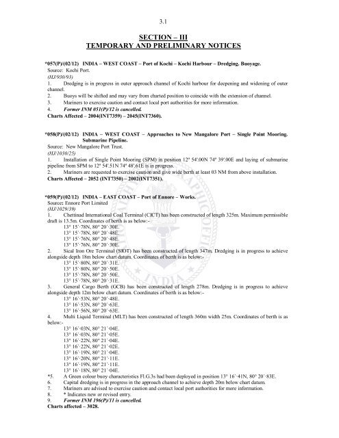
*057(P)/(<strong>02</strong>/12) INDIA – WEST COAST – Port <strong>of</strong> Kochi – Kochi Harbour – Dredging. Buoyage.<br />
Source: Kochi Port.<br />
(HJ/930/93)<br />
1. Dredging is in progress in outer approach channel <strong>of</strong> Kochi harbour for deepening and widening <strong>of</strong> outer<br />
channel.<br />
2. Buoys will be shifted and may vary from charted position to coincide with the extension <strong>of</strong> channel.<br />
3. Mariners to exercise caution and contact local port authorities for more information.<br />
4. Former INM 051(P)/12 is cancelled.<br />
Charts Affected – 2004(INT7359) – 2045(INT7360).<br />
*058(P)/(<strong>02</strong>/12) INDIA – WEST COAST – Approaches to New Mangalore Port – Single Point Mooring.<br />
Submarine Pipeline.<br />
Source: New Mangalore Port Trust.<br />
(HJ/1030/25)<br />
1. Installation <strong>of</strong> Single Point Mooring (SPM) in position 12º 54'.00N 74º 39'.00E and laying <strong>of</strong> submarine<br />
pipeline from SPM to 12º 54'.51N 74º 48'.61E is in progress.<br />
2. Mariners are requested to exercise caution and give wide berth at least 03 NM from above installation.<br />
Charts Affected – 2052 (INT7350) – 20<strong>02</strong>(INT7351).<br />
*059(P)/(<strong>02</strong>/12) INDIA – EAST COAST – Port <strong>of</strong> Ennore – Works.<br />
Source: Ennore Port Limited<br />
(HJ/1<strong>02</strong>9/39)<br />
1. Chettinad International Coal Terminal (CICT) has been constructed <strong>of</strong> length 325m. Maximum permissible<br />
draft is 13.5m. Coordinates <strong>of</strong> berth is as below:-<br />
13° 15´·78N, 80° 20´·30E.<br />
13° 15´·78N, 80° 20´·48E.<br />
13° 15´·76N, 80° 20´·48E.<br />
13° 15´·76N, 80° 20´·30E.<br />
2. Sical Iron Ore Terminal (SIOT) has been constructed <strong>of</strong> length 347m. Dredging is in progress to achieve<br />
alongside depth 18m below chart datum. Coordinates <strong>of</strong> berth is as below:-<br />
13° 15´·80N, 80° 20´·31E.<br />
13° 15´·80N, 80° 20´·50E.<br />
13° 15´·78N, 80° 20´·50E.<br />
13° 15´·78N, 80° 20´·31E.<br />
3. General Cargo Berth (GCB) has been constructed <strong>of</strong> length 278m. Dredging is in progress to achieve<br />
alongside depth 12m below chart datum. Coordinates <strong>of</strong> berth is as below:-<br />
13° 16´·53N, 80° 20´·48E.<br />
13° 16´·53N, 80° 20´·63E.<br />
13° 16´·56N, 80° 20´·63E.<br />
4. Multi Liquid Terminal (MLT) has been constructed <strong>of</strong> length 360m width 25m. Coordinates <strong>of</strong> berth is as<br />
below:-<br />
13° 16´·03N, 80° 21´·04E.<br />
13° 16´·03N, 80° 21´·05E.<br />
13° 16´·22N, 80° 21´·04E.<br />
13° 16´·22N, 80° 21´·<strong>02</strong>E.<br />
13° 16´·19N, 80° 21´·04E.<br />
13° 16´·20N, 80° 21´·11E.<br />
13° 16´·19N, 80° 21´·11E.<br />
13° 16´·18N, 80° 21´·04E.<br />
*5. A Green colour buoy characteristics Fl.G.3s had been deployed in position 13° 16´·41N, 80° 20´·83E.<br />
6. Capital dredging is in progress in the approach channel to achieve depth 20m below chart datum.<br />
7. Mariners are advised to exercise caution and contact local port authorities for more information.<br />
8. * Indicates new or revised entry.<br />
9. Former INM 196(P)/11 is cancelled.<br />
Charts affected – 3<strong>02</strong>8.


