Edition 02 of 2012. - Indian Naval Hydrographic Department
Edition 02 of 2012. - Indian Naval Hydrographic Department
Edition 02 of 2012. - Indian Naval Hydrographic Department
Create successful ePaper yourself
Turn your PDF publications into a flip-book with our unique Google optimized e-Paper software.
5. 1<br />
SECTION – V<br />
NAVAREA – VIII WARNINGS IN FORCE<br />
1. For details <strong>of</strong> NAVAREA limits and organisation/coordination, please refer to Notice No. 12 <strong>of</strong> the Special<br />
edition <strong>of</strong> <strong>Indian</strong> Notice to Mariners – 2008.<br />
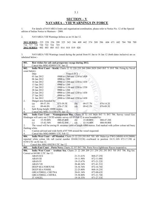
2. NAVAREA VIII Warnings Inforce as on 16 Jan 12.<br />
2011 SERIES – 225 228 256 299 325 343 346 409 442 574 589 596 604 671 682 704 708 709<br />
716 717 718 720 722 724 725<br />
2012 SERIES – 0<strong>02</strong> 003 005 013 014 018 019 <strong>02</strong>0<br />
3. NAVAREA VIII Warnings issued during the period from 01 Jan to 16 Jan 12 (both dates inclusive) are as<br />
tabulated below:-<br />
001. Best wishes for safe and prosperous voyage during <strong>2012.</strong><br />
2. Cancel this MSG <strong>02</strong>0959 UTC Jan 12.<br />
0<strong>02</strong>. India West Coast – Kochi. Charts 22 32 220 259 260 2004 2<strong>02</strong>9 2045 INT 71 INT 706. Firing by <strong>Naval</strong><br />
coast battery:<br />
Date Time (UTC)<br />
03 Jan 2012 0900 to 1200 and 1230 to 1430<br />
06 Jan 2012 0900 to 1200<br />
10 Jan 2012 0900 to 1200 and 1230 to 1430<br />
13 Jan 2012 0900 to 1200<br />
17 Jan 2012 0900 to 1130 and 1230 to 1530<br />
20 Jan 2012 0900 to 1200<br />
24 Jan 2012 0900 to 1200 and 1230 to 1430<br />
27 Jan 2012 0900 to 1200<br />
31 Jan 2012 0900 to 1200 and 1230 to 1430<br />
2. Danger area bounded by:<br />
(a) 09-57.5N 075-59.5E (b) 09-57.7N 076-14.2E<br />
(c) 09-44.0N 076-17.5E (d) 09-42.5N 076-09.5E<br />
3. Safe flying height 10000 metres.<br />
4. Cancel this MSG 311530 UTC Jan 12.<br />
003. India East Coast – Nizamapatnam Bay. Charts 31 32 355 3<strong>02</strong>6 INT 71 INT 706. Survey vessel Geo<br />
Hindsagar will carry out 2 D/3D seismic survey till 03 Feb 12 in area bounded by:<br />
(a) 15-39.00N 080-45.00E (b) 15-40.00N 080-47.28E<br />
(c) 15-42.54N 080-52.00E (d) 15-34.00N 080-50.00E<br />
2. The vessel will be towing 01 streamer cable <strong>of</strong> length 6000 metres. End marked with yellow colour tail buoy<br />
flashing white.<br />
3. Caution advised and wide berth <strong>of</strong> 07 NM around the vessel requested.<br />
4. Cancel this MSG 040001 UTC Feb 12.<br />
004. India West Coast – <strong>of</strong>f Mumbai. Charts 21 22 255 293 INT 705. MV Malaviya-TWO (MMSI 419128000)<br />
reported white colour life raft (serial number D16SU33238) overboard in position 18-51.16N 072-17.39E at<br />
0150 UTC on <strong>02</strong> Jan 12.<br />
2. Cancel this MSG 05<strong>02</strong>50 UTC Jan 12.<br />
005. India East Coast – Porto Novo. Charts 32 357 INT 706. Porto Novo lighthouse Racon inoperative.<br />
006. India West Coast – Arabian Sea. Charts 21 22 208 209 211 254 292 293 INT 705 INT 706. Rig list.<br />
Correct at 041001 UTC Jan 12:<br />
ABAN ICE 21-31.61N 068-27.25E<br />
ABAN III 19-11.98N 072-11.00E<br />
ABAN IV 19-15.67N 071-21.22E<br />
ABAN VII 20-40.34N 071-41.51E<br />
DEEP SEA FORTUNE 18-34.76N 072-16.76E<br />
DEEP SEA FOSSIL 22-25.00N 068-14.25E<br />
GREATDRILL CHETNA 20-01.34N 072-00.62E<br />
GREATDRILL CHITRA 19-38.00N 071-21.74E<br />
JT ANGEL 19-18.55N 071-27.53E


