Edition 02 of 2012. - Indian Naval Hydrographic Department
Edition 02 of 2012. - Indian Naval Hydrographic Department
Edition 02 of 2012. - Indian Naval Hydrographic Department
You also want an ePaper? Increase the reach of your titles
YUMPU automatically turns print PDFs into web optimized ePapers that Google loves.
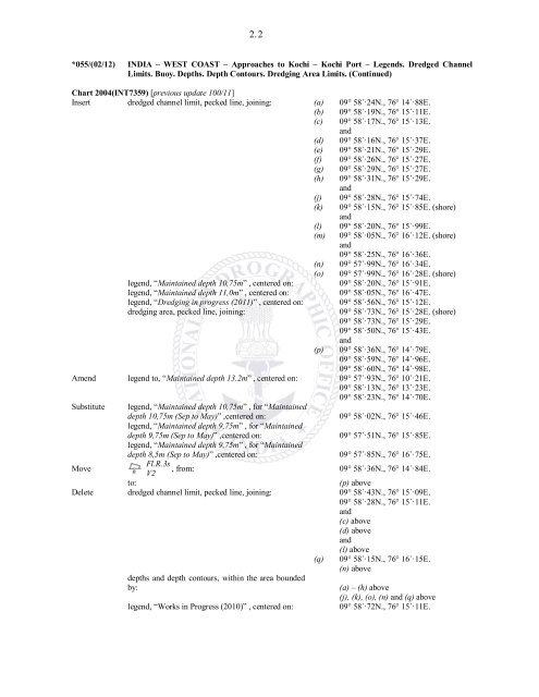
2. 2<br />
*055/(<strong>02</strong>/12) INDIA – WEST COAST – Approaches to Kochi – Kochi Port – Legends. Dredged Channel<br />
Limits. Buoy. Depths. Depth Contours. Dredging Area Limits. (Continued)<br />
Chart 2004(INT7359) [previous update 100/11]<br />
Insert dredged channel limit, pecked line, joining: (a) 09° 58´·24N., 76° 14´·88E.<br />
(b) 09° 58´·19N., 76° 15´·11E.<br />
(c) 09° 58´·17N., 76° 15´·13E.<br />
and<br />
(d) 09° 58´·16N., 76° 15´·37E.<br />
(e) 09° 58´·21N., 76° 15´·29E.<br />
(f) 09° 58´·26N., 76° 15´·27E.<br />
(g) 09° 58´·29N., 76° 15´·27E.<br />
(h) 09° 58´·31N., 76° 15´·29E.<br />
and<br />
(j) 09° 58´·28N., 76° 15´·74E.<br />
(k) 09° 58´·15N., 76° 15´·85E. (shore)<br />
and<br />
(l) 09° 58´·20N., 76° 15´·99E.<br />
(m) 09° 58´·05N., 76° 16´·12E. (shore)<br />
and<br />
09° 58´·25N., 76° 16´·36E.<br />
(n) 09° 57´·99N., 76° 16´·34E.<br />
(o) 09° 57´·99N., 76° 16´·28E. (shore)<br />
legend, “Maintained depth 10,75m” , centered on: 09° 58´·20N., 76° 15´·91E.<br />
legend, “Maintained depth 11,0m” , centered on: 09° 58´·05N., 76° 16´·47E.<br />
legend, “Dredging in progress (2011)” , centered on: 09° 58´·56N., 76° 15´·12E.<br />
dredging area, pecked line, joining: 09° 58´·73N., 76° 15´·28E. (shore)<br />
09° 58´·73N., 76° 15´·29E.<br />
09° 58´·50N., 76° 15´·43E.<br />
and<br />
(p) 09° 58´·36N., 76° 14´·79E.<br />
09° 58´·59N., 76° 14´·96E.<br />
09° 58´·60N., 76° 14´·98E.<br />
Amend legend to, “Maintained depth 13.2m” , centered on: 09° 57´·93N., 76° 10´·21E.<br />
09° 58´·13N., 76° 13´·23E.<br />
09° 58´·23N., 76° 14´·70E.<br />
Substitute legend, “Maintained depth 10,75m” , for “Maintained<br />
depth 10,75m (Sep to May)” ,centered on:<br />
legend, “Maintained depth 9,75m” , for “Maintained<br />
09° 58´·<strong>02</strong>N., 76° 15´·46E.<br />
depth 9,75m (Sep to May)” ,centered on:<br />
legend, “Maintained depth 9,75m” , for “Maintained<br />
09° 57´·51N., 76° 15´·85E.<br />
depth 8,5m (Sep to May)” ,centered on: 09° 57´·85N., 76° 16´·75E.<br />
Move<br />
Fl.R.3s<br />
, from: 09° 58´·36N., 76° 14´·84E.<br />
V2<br />
to: (p) above<br />
Delete dredged channel limit, pecked line, joining: 09° 58´·43N., 76° 15´·09E.<br />
09° 58´·28N., 76° 15´·11E.<br />
and<br />
(c) above<br />
(d) above<br />
and<br />
(l) above<br />
(q) 09° 58´·15N., 76° 16´·15E.<br />
(n) above<br />
depths and depth contours, within the area bounded<br />
by: (a) – (h) above<br />
(j), (k), (o), (n) and (q) above<br />
legend, “Works in Progress (2010)” , centered on: 09° 58´·72N., 76° 15´·11E.


