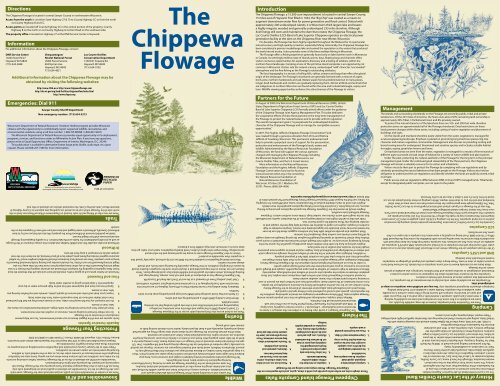
The Chippewa Flowage - Wisconsin Department of Natural Resources
The Chippewa Flowage - Wisconsin Department of Natural Resources
The Chippewa Flowage - Wisconsin Department of Natural Resources

You also want an ePaper? Increase the reach of your titles
YUMPU automatically turns print PDFs into web optimized ePapers that Google loves.
Directions<br />
<strong>The</strong> <strong>Chippewa</strong> <strong>Flowage</strong> is located in central Sawyer County in northwestern <strong>Wisconsin</strong>.<br />
Access from the south is via either State Highway 27 & 70 to County Highway CC or from the north<br />
via County Highway B and CC.<br />
Access points are located <strong>of</strong>f County Highway CC in the central portion <strong>of</strong> the property, County<br />
Highway B on the north or via County Highway G to Dam Road on the southeast side.<br />
<strong>The</strong> property <strong>of</strong>fice is located on Highway 27 at the DNR Service Center in Hayward.<br />
Information<br />
For additional information about the <strong>Chippewa</strong> <strong>Flowage</strong>, contact:<br />
DNR Service Center<br />
10220 State Rd 27<br />
Hayward, WI 54843<br />
(715) 634-2688<br />
Chequamegon/<br />
Nicolet National Forest<br />
USDA Forest Service<br />
604 Nyman Ave<br />
Hayward, WI 54843<br />
715) 634-4821<br />
Portions <strong>of</strong> this property were acquired and/or<br />
developed with Knowles-Nelson Stewardship funds.<br />
Lac Courte Oreilles<br />
Conservation <strong>Department</strong><br />
13394 W. Trepania Rd.<br />
Hayward, WI 54843<br />
(715) 634-0102<br />
Additional information about the <strong>Chippewa</strong> <strong>Flowage</strong> may be<br />
obtained by visiting the following websites:<br />
Emergencies: Dial 911<br />
http://www.CFLA.us or http://www.<strong>Chippewa</strong>flowage.com<br />
http://dnr.wi.gov/org/land/facilities/chippewaflow/index.html<br />
http://www.cfapoa.org<br />
Sawyer County Sheriff <strong>Department</strong><br />
Non-emergency number: (715) 634-5213<br />
<strong>Wisconsin</strong>’s <strong>Department</strong> <strong>of</strong> <strong>Natural</strong> <strong>Resources</strong>’ Violation Hotline program provides <strong>Wisconsin</strong><br />
citizens with the opportunity to confidentially report suspected wildlife, recreational, and<br />
environmental violations using a toll free number: 1-800-TIP-WDNR (1-800-847-9367)<br />
<strong>The</strong> <strong>Wisconsin</strong> <strong>Department</strong> <strong>of</strong> <strong>Natural</strong> <strong>Resources</strong> provides equal opportunity in its employment,<br />
programs, services, and functions under an Affirmative Action Plan. If you have any questions,<br />
please write to Equal Opportunity Office, <strong>Department</strong> <strong>of</strong> Interior, Washington, D.C. 20240.<br />
This publication is available in alternative format (large print, Braille, audio tape, etc) upon<br />
request. Please call 608-267-7490 for more information.<br />
PUB-LF-019 2010<br />
<strong>The</strong>re are two miles <strong>of</strong> hiking and ski trails located on <strong>Department</strong> <strong>of</strong> <strong>Natural</strong> <strong>Resources</strong> land on the<br />
north side <strong>of</strong> the <strong>Flowage</strong> which can be accessed via a parking area adjacent to County Highway B<br />
between Moss Creek and Hay Creek. No motorized vehicles are allowed on this trail.<br />
.<br />
Trails<br />
Driftwood provides valuable fish and wildlife habitat and adds to the unique character <strong>of</strong> the <strong>Flowage</strong>,<br />
as well as providing stabilization for banks and the lake bottom. It is rapidly disappearing through<br />
natural processes and from illegal harvest.<br />
State law prohibits removal <strong>of</strong> driftwood from the property. We also ask that you not try to burn<br />
driftwood. Generally, driftwood is water logged and does not burn well even if it appears dry on the<br />
outside<br />
Driftwood<br />
Firewood can harbor pests such as gypsy moths, emerald ash borer and oak wilt that threaten the local<br />
forest. New regulations regarding the transport <strong>of</strong> firewood are aimed at stopping the threats. It is now<br />
illegal to bring firewood to this or any other state property from more than 50 miles away. It is also<br />
illegal to bring firewood from out <strong>of</strong> state. You should consider purchasing locally harvested firewood to<br />
bring to your campsite. <strong>The</strong>re are several local businesses that sell bundled campfire wood. For added<br />
assurance against introducing forest pests, please burn all your firewood, do not leave it for the next<br />
camper and do not transport it away from the area.<br />
Fires and Firewood<br />
z Spray/rinse your boat and equipment with hot and/or high-pressure water or dry your<br />
equipment for 5 days before going to another water body.<br />
z Inspect your boat and trailer and remove all aquatic plants, animals and mud before leaving any<br />
lake, river or stream.<br />
z Do not transport any live fish away from a lake, river or stream unless they are bait fish purchased<br />
from a bait dealer and have not been exposed to water from that water body.<br />
z Drain all water from your boat including live wells, bilges, and bait buckets before you leave any<br />
lake, river or stream.<br />
Exotic species are one <strong>of</strong> the biggest threats to our natural environment. You can help prevent<br />
introduction <strong>of</strong> invasives to the <strong>Flowage</strong>.<br />
z Do not release live bait including worms, minnows or crayfish into the environment.<br />
Protecting Your <strong>Flowage</strong><br />
Aquatic Invasive Species<br />
<strong>The</strong>re are a number <strong>of</strong> snowmobile trails on public and private lands near the <strong>Flowage</strong>, some trails<br />
cross the <strong>Flowage</strong> on the ice. Snowmobiles are allowed on public lands on designated trails only.<br />
<strong>The</strong>re are ATV trails on the Chequamegon National Forest property near the <strong>Flowage</strong>. Please ride<br />
responsively and respect the property and rights <strong>of</strong> all landowners.<br />
Snowmobiles and ATVs are allowed on the ice <strong>of</strong> the <strong>Flowage</strong>, however, before venturing out onto<br />
the ice make sure conditions are safe and you know where you are going. Some areas are hazardous<br />
throughout the winter because <strong>of</strong> currents under the ice, so stay on the marked trails. In addition,<br />
fluctuating water levels can create uneven ice conditions.<br />
Please refer to the Sawyer County snowmobile trail map before snowmobiling on the property to<br />
determine those areas that are legal for snowmobile use.<br />
Request snowmobile trail maps or ATV trail maps from the Hayward Lakes Visitor and Convention<br />
Bureau, PO Box 1055, Hayward, WI 54843. Phone: (715)634-4801 or (800)724-2992<br />
Snowmobiles and ATVs<br />
<strong>The</strong><br />
<strong>Chippewa</strong><br />
<strong>Flowage</strong><br />
<strong>The</strong> <strong>Chippewa</strong> <strong>Flowage</strong> has an abundance <strong>of</strong> sand and rock bars, stumps, floating bogs and<br />
floating driftwood, which makes for good fish and wildlife habitat but could damage boats. <strong>The</strong>se<br />
features are not shown on the map provided and it should not be used for navigation. Boaters should<br />
be aware <strong>of</strong> changing conditions on the <strong>Flowage</strong>, especially fluctuating water levels, and should<br />
always exercise caution.<br />
<strong>Wisconsin</strong> Boating Regulations (available from the DNR) are strictly enforced, especially “speed that<br />
is no greater than reasonable or prudent.”<br />
Visitors to the <strong>Chippewa</strong> <strong>Flowage</strong> come to enjoy the quiet beauty and the wild natural<br />
surroundings. Please respect the rights <strong>of</strong> others, heed boating regulations, watch your wake, go slow,<br />
keep noise to a minimum and enjoy wildlife from a distance.<br />
z Chief Lake Landing (Town <strong>of</strong> Hayward) is at the end <strong>of</strong> Chief Lake Road <strong>of</strong>f County NN.<br />
z Blueberry Flats Landing (Lac Courte Oreilles Tribe) is <strong>of</strong>f County Highway CC across from the<br />
intersection with County Highway H. It is a primitive boat landing best suited for small boats.<br />
z CC North and Hay Creek Landings (both DNR) have large gravel parking areas but no toilet<br />
facilities.<br />
z Winter Dam Landing (DNR) <strong>of</strong>fers a paved parking area and toilets.<br />
<strong>The</strong>re are six boat access sites that provide public access to the <strong>Chippewa</strong> <strong>Flowage</strong>:<br />
z CC South Landing (DNR) is the largest and <strong>of</strong>fers the most amenities, including a<br />
large parking area and toilet facilities and is the only public landing that has drinking<br />
water available.<br />
Boating<br />
<strong>The</strong> waters and surrounding lands <strong>of</strong> the <strong>Flowage</strong> provide abundant aquatic and<br />
terrestrial habitats. A diverse variety <strong>of</strong> northern forest and aquatic wildlife find food, nest<br />
sites and shelter along the many miles <strong>of</strong> undeveloped mainland and island shoreline.<br />
<strong>The</strong> state-owned lands on the <strong>Chippewa</strong> <strong>Flowage</strong> are open to hunting. Consult <strong>Wisconsin</strong><br />
hunting regulations for season dates, times and bag limits.<br />
<strong>The</strong> <strong>Flowage</strong> provides exceptional nesting habitat for eagles and common loons. Keep your<br />
distance from eagle nests and boat slowly around loon nests for large wakes can destroy them. <strong>The</strong>re<br />
is a large great blue heron rookery on Banana Island; keep your distance from May through July to<br />
prevent disturbance. Mallards, wood ducks and hooded mergansers are common. Ospreys are spotted<br />
occasionally. Large numbers <strong>of</strong> waterfowl use the <strong>Flowage</strong> during spring and fall migration. Over 130<br />
species <strong>of</strong> birds have been observed on the <strong>Flowage</strong> or in the nearby forests. Deer coming down for a<br />
drink at the lake, otters popping their heads out <strong>of</strong> water or a family <strong>of</strong> raccoons carousing along the<br />
shoreline are common sights. Occasionally black bears, fishers and wolves are reported.<br />
Most <strong>of</strong> the animals found on the <strong>Flowage</strong> can be observed at close range if they are approached<br />
slowly and quietly, especially with a boat. Be particularly careful not to disturb nesting birds or<br />
animals with small young.<br />
Wildlife<br />
Introduction<br />
<strong>The</strong> <strong>Chippewa</strong> <strong>Flowage</strong>, a 15,300-acre impoundment is located in central Sawyer County,<br />
15 miles east <strong>of</strong> Hayward. First filled in 1924, the “Big Chip” was created as a means to<br />
augment downstream water flow for power generation and flood control. Dotted with<br />
approximately 200 undeveloped islands, it is <strong>Wisconsin</strong>’s third-largest lake and boasts<br />
a highly irregular, wooded and generally undeveloped 233-mile shoreline. Although<br />
Xcel Energy still owns and maintains the dam that creates the <strong>Chippewa</strong> <strong>Flowage</strong>, the<br />
Lac Courte Oreilles (LCO) Band <strong>of</strong> Lake Superior <strong>Chippewa</strong> operates an electrical power<br />
generation facility at the dam on the <strong>Chippewa</strong> River near Winter, <strong>Wisconsin</strong><br />
For decades, the <strong>Flowage</strong> has been highly regarded throughout the Midwest for its spectacular<br />
natural scenery and high-quality recreation, especially fishing. Historically, the <strong>Chippewa</strong> <strong>Flowage</strong> has<br />
been considered a premier muskellunge lake and earned the reputation as the waters that produced<br />
the world record musky. It also provides some <strong>of</strong> the finest walleye fishing in <strong>Wisconsin</strong>.<br />
<strong>The</strong> <strong>Flowage</strong> <strong>of</strong>fers a fishing experience generally found only on lakes farther north in Minnesota<br />
or Canada. Its seemingly endless maze <strong>of</strong> islands, points, bays, floating bogs and channels <strong>of</strong>fers<br />
visitors numerous opportunities for exploration, discovery and a feeling <strong>of</strong> wildness within the<br />
northern forest landscape. Camping at one <strong>of</strong> the primitive island campsites is an opportunity not<br />
common in <strong>Wisconsin</strong>. Visitors rate the natural scenery, undeveloped “wild” character, “uncrowded”<br />
atmosphere and the fine fishing as the <strong>Flowage</strong>’s outstanding attributes.<br />
<strong>The</strong> local topography is a mosaic <strong>of</strong> rolling hills, valleys, streams and bogs that reflect the glacial<br />
origin <strong>of</strong> the landscape. <strong>The</strong> <strong>Flowage</strong>’s shorelands are generally forested with a mixture <strong>of</strong> aspen,<br />
birch, pine, northern hardwoods and oak. Mature aspen forests predominate but in many places,<br />
longer-lived hardwoods and conifers are gradually replacing them. Almost all birds and animals that<br />
are indigenous to northern <strong>Wisconsin</strong> are found within the area and include bald eagle, osprey and<br />
loon. Wildlife viewing opportunities enhance the attractiveness <strong>of</strong> the <strong>Flowage</strong> to visitors.<br />
Partners for the Future<br />
In August <strong>of</strong> 2000, the <strong>Wisconsin</strong> <strong>Department</strong> <strong>of</strong> <strong>Natural</strong> <strong>Resources</strong> (DNR), United<br />
States <strong>Department</strong> <strong>of</strong> Agriculture Forest Service (USFS) and Lac Courte Oreilles<br />
Band <strong>of</strong> Lake Superior <strong>Chippewa</strong> (LCO) formally joined efforts under the guidance<br />
<strong>of</strong> the <strong>Chippewa</strong> <strong>Flowage</strong> Joint Agency Management Plan. This plan dedicates<br />
the cooperative efforts <strong>of</strong> these three partners to the long-term management <strong>of</strong><br />
the <strong>Flowage</strong> to protect the natural features and to provide uniform regulation.<br />
<strong>The</strong> overall management goal is “to perpetuate the undeveloped shoreline<br />
character <strong>of</strong> the <strong>Chippewa</strong> <strong>Flowage</strong> and to manage for compatible resource<br />
opportunities.”<br />
In 2007, <strong>The</strong> Hughes Jeffords <strong>Chippewa</strong> <strong>Flowage</strong> Conservation Fund<br />
was created through a generous donation from Chris and Patricia<br />
Jeffords <strong>of</strong> Couderay, <strong>Wisconsin</strong>. This permanent endowment will<br />
help to provide a perpetual source <strong>of</strong> support for the preservation,<br />
protection and enhancement <strong>of</strong> the <strong>Flowage</strong>’s lands, waters and<br />
wildlife. Administered by the <strong>Natural</strong> <strong>Resources</strong> Foundation<br />
<strong>of</strong> <strong>Wisconsin</strong>, the fund will support the various agencies<br />
charged with managing the <strong>Chippewa</strong> <strong>Flowage</strong> including<br />
the <strong>Wisconsin</strong> <strong>Department</strong> <strong>of</strong> <strong>Natural</strong> <strong>Resources</strong>, Lac<br />
Courte Oreilles Tribe, and the U.S. Forest Service.<br />
More information on the <strong>Natural</strong> <strong>Resources</strong><br />
Foundation and the Hughes Jeffords <strong>Chippewa</strong><br />
<strong>Flowage</strong> Conservation fund can be found at:<br />
www.wisconservation.org or by contacting<br />
the <strong>Natural</strong> <strong>Resources</strong> foundation at:<br />
<strong>Natural</strong> <strong>Resources</strong> Foundation <strong>of</strong><br />
<strong>Wisconsin</strong>, P.O. Box 2317, Madison, WI<br />
53701. Phone: (608) 264-4096.<br />
<strong>The</strong> <strong>Chippewa</strong> <strong>Flowage</strong> is a world-class fishery in a wilderness-like setting. It is home to<br />
the world-record muskellunge-- a 69-pound, 11-ounce monster caught by Louis Spray<br />
in 1949 and upheld by the Freshwater Fishing Hall <strong>of</strong> Fame as one <strong>of</strong> the most welldocumented<br />
world record fish <strong>of</strong> all time.<br />
Walleye, black crappie, muskellunge and bluegill are the most popular species among<br />
<strong>Flowage</strong> anglers today. DNR fishery management strategies are aimed at optimizing conditions for<br />
the reproduction, growth and survival to preferred sizes <strong>of</strong> these species in particular.<br />
Yellow perch and smallmouth bass add positive elements <strong>of</strong> diversity to the <strong>Flowage</strong> fishery.<br />
Perch numbers are on the rise and the smallmouth fishery has become outstanding in the darker,<br />
river-connected waters <strong>of</strong> the eastern basin. Largemouth bass and northern pike are present in everincreasing<br />
numbers particularly in the clearer, weedier western basin.<br />
Increased numbers <strong>of</strong> largemouth bass and northern pike may please some anglers, but these<br />
predators threaten to reduce the reproductive survival <strong>of</strong> walleye and muskellunge, respectively.<br />
Without moderate to high numbers <strong>of</strong> walleye to prey upon young panfish, crappie and bluegill could<br />
become too numerous to grow well and achieve the sizes that <strong>Flowage</strong> anglers prefer.<br />
In order to focus on achieving the highest priority objectives for the <strong>Chippewa</strong> <strong>Flowage</strong> fishery,<br />
DNR fishery biologists urge <strong>Flowage</strong> anglers to harvest (keep) up to their daily limits <strong>of</strong> legal-size<br />
largemouth bass and northern pike. Both are excellent table fare if prepared properly.<br />
In addition, biologists urge restraint in the harvest <strong>of</strong> walleye and they strongly encourage catchand-release<br />
<strong>of</strong> muskellunge and smallmouth bass. Anglers may be asked to support more protective<br />
length limits for muskies and smallies in the near future.<br />
Anglers wishing to have fun with their children while assembling a good fish fry cannot hurt the<br />
fishery by keeping some tasty six- to eight-inch bluegill, which have become abundant in recent years.<br />
Shallow bays attract thousands <strong>of</strong> spawning bluegill throughout the spring; bluegills are easily caught<br />
by drifting worm chunks over sunken bogs throughout the summer.<br />
Black crappies also provide excellent table fare, but evidence suggests these fish can be overharvested<br />
once they reach desirable size (approximately nine inches). Despite moderate to high<br />
numbers <strong>of</strong> crappie, anglers are urged to abide by the reduced daily bag limit for crappie and to<br />
consider keeping only those needed for a good meal or two.<br />
Folks who like to eat fish might also consider keeping some <strong>of</strong> the abundant, quality-size bullheads<br />
that can be caught with worm chunks over sunken bogs. Unlike some southern waters, <strong>Chippewa</strong><br />
<strong>Flowage</strong> bullheads taste excellent.<br />
Anglers should be aware that the <strong>Chippewa</strong> <strong>Flowage</strong> has special regulations pertaining to fishing<br />
seasons, size and bag limits. Consult the <strong>Wisconsin</strong> fishing regulations pamphlet for more details.<br />
Anglers who wish to read a detailed analysis <strong>of</strong> fish population status and DNR plans for managing<br />
the fishery can find the August 2007 <strong>Chippewa</strong> <strong>Flowage</strong> Fishery Management Plan posted online in<br />
PDF format at http://www.dnr.state.wi.us/org/gmu/upchip/fisheries/reports.htm.<br />
10. Please be considerate <strong>of</strong> others.<br />
Keep noise to a minimum. Please<br />
clean up after your pet. Leave the<br />
campsite cleaner than you found<br />
it.<br />
9. Chainsaws, generators and<br />
fireworks are prohibited.<br />
8. Please do not cut, carve or deface<br />
trees, tables or benches, or drive<br />
nails into trees. Please do not<br />
hang lanterns from trees.<br />
7. All plastic, cans, glass and trash<br />
must be carried out and disposed<br />
<strong>of</strong> properly when leaving. Trash<br />
receptacles are provided at public<br />
landings.<br />
6. Fire Safety: Please burn only<br />
paper products and wood in<br />
fire pits and extinguish fires<br />
completely using water or clean<br />
soil. Do not leave fire unattended.<br />
5. Campsites are to be kept free<br />
<strong>of</strong> litter, rubbish and other<br />
flammable materials.<br />
<strong>The</strong> Fishery<br />
4. Please use the pit toilet provided<br />
at each campsite.<br />
3. Camper maximum stay is 10 days.<br />
2. No unattended camping gear<br />
may be left to save a campsite<br />
overnight. Sites must be occupied<br />
the same day that they are set up.<br />
1. Camping is allowed only at<br />
designated, signed island<br />
campsites. No new campsites may<br />
be established.<br />
<strong>The</strong>se simple rules are enforced to provide you with a clean, quiet, and safe experience on the<br />
<strong>Chippewa</strong> <strong>Flowage</strong>. Please enjoy your outing on the <strong>Flowage</strong>!<br />
<strong>Chippewa</strong> <strong>Flowage</strong> Island Campsite Rules<br />
Management<br />
<strong>The</strong> islands and surrounding shorelands on the <strong>Flowage</strong> are owned by public, tribal and private<br />
landowners. Of the 233 miles <strong>of</strong> shoreline, the State owns about 50%; remaining land ownership is<br />
approximately 30% Tribal, 12% National Forest and 8% privately owned.<br />
To protect the natural character <strong>of</strong> the lakeshore there are 100- and 200-foot wide shoreline<br />
protection zones on approximately half <strong>of</strong> the <strong>Flowage</strong> shorelands. Deed restrictions on these<br />
lands prevent changes within these zones, including cutting <strong>of</strong> native vegetation and placement <strong>of</strong><br />
buildings and signs.<br />
On the islands and mainland shoreline easily visible from the water, vegetation is managed for<br />
a natural-appearing landscape. Emphasis is placed on promoting long-lived tree species, big tree<br />
character and mature vegetative communities. Management also focuses on providing nesting and<br />
brood-rearing areas for endangered, threatened and sensitive species and includes suitable habitat<br />
for eagles, osprey, great blue herons and loons.<br />
On backland areas not seen from the water, vegetation is managed for a mosaic <strong>of</strong> forest stands <strong>of</strong><br />
different ages to provide a broad range <strong>of</strong> habitats for a variety <strong>of</strong> native wildlife and plant species.<br />
Under the plan, protecting the natural aesthetics <strong>of</strong> the <strong>Flowage</strong> for the long term is the principal<br />
management goal. Under the continued good stewardship <strong>of</strong> the three partners, the <strong>Chippewa</strong><br />
<strong>Flowage</strong> will remain a valuable resource for its visitors and inhabitants.<br />
Visitors must do their part to protect the <strong>Flowage</strong> by complying with use regulations and by<br />
stridently protecting the natural lakeshores that draw people to the <strong>Flowage</strong>. Visitors also hold an<br />
obligation to understand the use regulations and identify whether the lands are publicly owned, tribal<br />
or private.<br />
Public access and use regulations differ between DNR, LCO and USFS managed lands. Tribal lands,<br />
except for designated public campsites, are not open to the public.<br />
Currently the Lac Courte Oreilles Conservation <strong>Department</strong> provides island camping by reservation<br />
and fee on six island campsites. <strong>The</strong> fee for camping is $20.00, and is payable to the LCO Conservation<br />
<strong>Department</strong>. Reservations may be made by calling (715) 634-0102. <strong>The</strong> LCO island campsites are<br />
located in the southeast part <strong>of</strong> the <strong>Chippewa</strong> <strong>Flowage</strong> and consist <strong>of</strong> Chipmunk Island, Loon Point,<br />
Loon Cove, Pine Island, Campers Island and Wagon Wheel Island.<br />
This area <strong>of</strong> the <strong>Flowage</strong> is <strong>of</strong> great cultural and historical significance to the Lac Courte Oreilles<br />
Tribe. <strong>The</strong> Ojibwe people have great respect for these waters that now cover areas <strong>of</strong> their tribal<br />
homeland and wish for you to share their respect. While camping on these islands please do not cut<br />
wood for fires. Even if a tree is dead, it may not be cut for firewood.<br />
LCO Campsites<br />
Of the 18 total campsites on the <strong>Flowage</strong>, eleven are on <strong>Wisconsin</strong> DNR islands and one is on an island<br />
under USFS ownership with the remainder on LCO tribal-owned islands. DNR and USFS campsites are<br />
available on a first-come, first-served basis. One campsite, Cedar Tops West, has been improved with<br />
accessible facilities and can be reserved by persons with disabilities by contacting the Hayward DNR<br />
Office: (715) 634-2688. If not being occupied by a reservation, this campsite is also open on a firstcome,<br />
first-served basis.<br />
DNR and USFS Campsites<br />
<strong>The</strong>re are 18 primitive island campsites, shown on the map, available for public use.<br />
Some are available on a first-come, first-served basis and some are available by making<br />
a reservation. Each public campsite is marked with a sign and has a fire ring, picnic table<br />
and open-air box latrine. Campers will need to bring or filter water, as there is no potable<br />
water available at the campsites. Potable water is available at CC South boat landing.<br />
Camping is allowed in designated campsites only. You may not establish new campsites or camp at<br />
undesignated sites.<br />
All campsites are accessible by water only and due to the remoteness <strong>of</strong> the campsites, it is<br />
recommended that campers leave an itinerary with friends or relatives.<br />
Campsites may be closed or relocated to allow the vegetation to recover and/or to protect<br />
threatened, endangered, or sensitive species and their habitats. Camping is also available at private<br />
resorts on the <strong>Flowage</strong>.<br />
Black bears are occasionally known to visit some campsites on the islands. Do not leave food items<br />
on picnic tables or store in tents. Please keep a clean campsite and deposit all garbage in receptacles<br />
located at the public boat landings.<br />
Camping<br />
<strong>The</strong> Lac Courte Oreilles Band <strong>of</strong> Lake Superior <strong>Chippewa</strong> Indians<br />
<strong>of</strong> <strong>Wisconsin</strong> has been centered on several lakes in the area <strong>of</strong><br />
the headwaters <strong>of</strong> the <strong>Chippewa</strong> River since the mid-eighteenth<br />
century. <strong>The</strong> name comes from a large lake on the reservation’s<br />
western boundary. Although the French name, Lac Courte Oreilles,<br />
literally translates to “Lake <strong>of</strong> the Short Ears,” the intention <strong>of</strong> the<br />
name is unknown. Regardless <strong>of</strong> its origin, the name describes a<br />
significant Ojibwe tribe, a beautiful lake and the Tribe’s “Reserve<br />
Tract,” or reservation, as established by treaty.<br />
<strong>The</strong> first permanent trading post was built in 1800 by the North<br />
West Fur Trading Company. John Baptiste Corbin became clerk <strong>of</strong><br />
the post and the area’s first permanent white settler. In the years<br />
to follow, “the white man” visited the Lac Courte Oreilles in larger<br />
numbers; including Henry Schoolcraft, an Indian agent for the<br />
Michigan territory, who visited the area in 1831 and would later<br />
discover the headwaters <strong>of</strong> the Mississippi River.<br />
In 1825, 1837 and 1842, many tribes <strong>of</strong> the Ojibwe Nation entered into sovereign treaties with the<br />
United States, ceding vast territories <strong>of</strong> land and reserving unto themselves significant rights and privileges.<br />
Please respect tribal property, rights and customs.<br />
History <strong>of</strong> the Lac Courte Oreilles Band
Map Locations and GPS Coordinates for Camping and Boat Landings<br />
DNR Campsite Section TSP Range QQuarter Latitude<br />
(Degrees-Min-Sec)<br />
Cedar Tops East<br />
22 40N 7W NE SW N45 56 02<br />
Cedar Tops West<br />
22 40N 7W NE SW N45 56 03<br />
Crane Creek Island 16 40N 7W NW SW N45 56 47<br />
Darrow Island<br />
11 40N 7W SE NE N45 57 49<br />
Dolly Island<br />
11 40N 7W SE SE N45 57 27<br />
Eagles Nest Island 12 40N 7W SW SE N45 57 37<br />
Little Banana Island 27 40N 7W NW NW N45 55 31<br />
Pine North Island 28 40N 7W NE NW N45 55 38<br />
Pine West Island<br />
28 40N 7W NE NW N45 55 35<br />
Turkey Vulture Round Island 26 40N 7W NE NW N45 55 38<br />
Weiner IslandLake<br />
13 40N 7W NE NE N45 57 12<br />
Cedar Swamp (USFS)<br />
LCO Tribal Campsites<br />
27 40N 6W SW SE N45 55 45<br />
Flat Island<br />
27 40N 7W SE SE N45 54 59<br />
Sister Island<br />
20 40N 6W NW SW N45 55 59<br />
Headflyer Island<br />
28 40N 6W NW SE N45 55 00<br />
Wagon Wheel Island 32 40N 6W NW SE Lawry N45 54 Rd. 12<br />
Campers Island<br />
28 40N 6W SW SW N45 54 48<br />
Chipmunk Island<br />
Boat Landinds<br />
20 40N 6W NE SW N45 55 51<br />
County Hwy CC North 15 40N 7W NW NW N45 57 07<br />
County Hwy CC South 26 40N 7W NE NE N45 55 30<br />
Hay CreekLittle<br />
1 40N 7W NE NE N45 58 52<br />
Round<br />
Winter Dam<br />
Lake<br />
2 39N 6W NW SE N45 53 22<br />
Osprey<br />
To<br />
Reserve<br />
Ck.<br />
NN<br />
catcher<br />
Dream Rd.<br />
Larush Rd.<br />
NN<br />
N<br />
World's<br />
<strong>The</strong><br />
Graveyard<br />
Cranberry<br />
Bog<br />
To<br />
Couderay<br />
Black Bear Rd.<br />
Chief Lake<br />
Daggett's<br />
CC<br />
End Rd.<br />
Sunfish<br />
Bay<br />
Ikwe<br />
Bay<br />
Rd.<br />
Daggett's<br />
Bay<br />
South<br />
Bay<br />
Rd.<br />
Conger Lane<br />
Pike<br />
L.<br />
Osprey<br />
Lake<br />
Lac Cour te Oreilles<br />
Reservation<br />
Sunfish<br />
Lake<br />
Chief<br />
Lake<br />
(Akwa'wening)<br />
LCO Res.<br />
McClaine Rd.<br />
Crane Lake<br />
Crane Creek<br />
Lost<br />
L.<br />
Channel<br />
Lac Cour te Oreilles Res.<br />
Chicago<br />
Bay<br />
Tyner Lake<br />
Jasek Rd.<br />
Minnesota<br />
Bay<br />
Lac Cour te Oreilles Reservaton<br />
Tiger Musky Rd.<br />
Blueberry Av.<br />
Longitude<br />
(Degrees-Min-Sec)<br />
W91 13 35<br />
W91 13 39<br />
W91 15 05<br />
W91 11 50<br />
W91 11 38<br />
W91 10 53<br />
W91 13 56<br />
W91 14 49<br />
W91 14 50<br />
W91 12 19<br />
W91 10 36<br />
W91 06 00<br />
W91 13 08<br />
W91 08 59<br />
W91 07 05<br />
W91 07 15<br />
W91 07 46<br />
W91 08 36<br />
W91 13 47<br />
W91 11 43<br />
W91 10 34<br />
W91 04 49<br />
To Hayward<br />
LCO Res.<br />
CC<br />
Blueberry<br />
Lake<br />
Pine<br />
Island<br />
L.<br />
North<br />
West<br />
Miles Pt.<br />
Kelsey Rd.<br />
Rice Lake<br />
Pipestone<br />
Mud Lake<br />
Ck.<br />
Callahan<br />
Lake<br />
Reed<br />
L.<br />
Crane<br />
Creek Is.<br />
Sandy Pt. Rd.<br />
Reed L. Rd.<br />
Crystal<br />
L.<br />
Big Banana Is.<br />
Pine Is.<br />
Oak Rd.<br />
Sand Is.<br />
LCO Res.<br />
H<br />
CC<br />
West<br />
Camp One Ck.<br />
Chief River Rd.<br />
Glover<br />
L.<br />
Milwaukee<br />
Bay<br />
CHIEF RIVER<br />
WILDLIFE AREA<br />
Blueberry<br />
Flats<br />
Callahan Lake Rd.<br />
Little Banana Is.<br />
To<br />
Radisson<br />
Chief<br />
Twin Bay Rd.<br />
CC NORTH<br />
La<br />
c<br />
Flat<br />
Island<br />
James<br />
River<br />
Cedar Tops Is.<br />
Birch Is.<br />
East<br />
Co<br />
ur<br />
te<br />
Ore<br />
il<br />
le<br />
s<br />
Bay<br />
B<br />
New Rice Lake<br />
Two<br />
Blueberry<br />
Darrow<br />
Is.<br />
Turkey<br />
Vulture Is.<br />
Scott Lake<br />
Blueberry Firelane<br />
To<br />
STH 77<br />
A<br />
Musky<br />
Bay<br />
Scott<br />
Island<br />
Darrow<br />
Is.<br />
Kavanagh<br />
Bay<br />
CC SOUTH<br />
Re<br />
se<br />
rv<br />
at<br />
io<br />
Boys Lake<br />
Carpenter<br />
L.<br />
Creek<br />
n<br />
Moss<br />
Pine Pt.<br />
Moss<br />
Creek<br />
Bay<br />
Creek<br />
Dolly Is.<br />
CC<br />
Ghost Is.<br />
Flemings<br />
Bar<br />
Riisberg<br />
Bar<br />
HAY<br />
CREEK<br />
Eagle<br />
Nest Is.<br />
Bunker<br />
Lake<br />
Snake Is.<br />
NEW POST<br />
(PAHQUAHWONG)<br />
Hell's Half Acre<br />
Woodland Rd<br />
Lampe Rd.<br />
<strong>Flowage</strong> Rd.<br />
Dance Rd.<br />
LCO Reservation<br />
Hall<br />
Weiner Is.<br />
Hay Creek<br />
Narrows<br />
Pete's<br />
Bar<br />
La<br />
c Co<br />
ur<br />
te<br />
Ore<br />
il<br />
le<br />
s Re<br />
se<br />
rv<br />
at<br />
io<br />
n<br />
Spooky<br />
Bunker<br />
Bay<br />
Pokegama<br />
Lake<br />
Granite<br />
Bay<br />
Heisling Rd.<br />
(El Ck.<br />
mer's)<br />
Hay<br />
Dunn Rovin Rd<br />
Popple Is.<br />
Little<br />
Pete's Bar<br />
<strong>The</strong> Birches<br />
Rd.<br />
B<br />
Hay Lake<br />
Moonshine L.<br />
(Desire)<br />
Indian Trail<br />
Creek<br />
CHEQUAMEGON<br />
Pork<br />
Barrel Is.<br />
Lessards<br />
Bay<br />
Chipmunk<br />
Is.<br />
FS 319<br />
McGilligan Rd.<br />
River<br />
Rd.<br />
James<br />
L.<br />
Sister<br />
Is.<br />
Three<br />
Sisters<br />
Is.<br />
NATIONAL<br />
Moore's<br />
Bay<br />
Church<br />
Bars<br />
Clyde's<br />
Point<br />
Drake<br />
Chief<br />
Narrows<br />
Charlie's Bay<br />
Lac Cour te<br />
Oreilles<br />
Reservation<br />
Island Campsites<br />
Creek<br />
La<br />
c<br />
S<br />
Sherman<br />
Bay<br />
Cranberry<br />
Bars<br />
LC<br />
O Re<br />
s .<br />
Cranberry<br />
Narrows<br />
Big Timber Is.<br />
WI Dept <strong>Natural</strong> <strong>Resources</strong><br />
Lac Courte OreillesTribe<br />
USDA Forest Service<br />
Boat Launch<br />
WI Dept <strong>Natural</strong> <strong>Resources</strong><br />
Lac Courte Oreilles Tribe<br />
Town <strong>of</strong> Hayward<br />
(No Parking Available)<br />
Campers<br />
Is.<br />
FOREST<br />
Co<br />
ur<br />
te<br />
Yankee Joe<br />
Ck.<br />
Lake <strong>Chippewa</strong><br />
Goose<br />
L.<br />
Moses<br />
Bay<br />
Cranberry<br />
Lake<br />
Headflyer<br />
Is.<br />
(Niganosh)<br />
Wagon<br />
Wheel Is.<br />
Ore<br />
il<br />
le<br />
s<br />
La<br />
c<br />
<strong>The</strong><br />
Nursey<br />
To<br />
Moose<br />
Lake<br />
LCO Res.<br />
Re<br />
se<br />
rv<br />
at<br />
io<br />
Co<br />
ur<br />
te<br />
n<br />
Reservation<br />
Oreilles<br />
Little Cranberry Ck.<br />
Cedar Swamp<br />
Venison<br />
Lake<br />
B<br />
Little<br />
Cranberry<br />
Lake<br />
Chip<br />
North Fork<br />
Fawn<br />
Lake<br />
Cranberry Ck.<br />
CHEQUAMEGON<br />
Public Land Management<br />
River<br />
pewa<br />
Cedar Swamp Is.<br />
WINTER DAM<br />
DNR Managed Land<br />
Federal Land<br />
Lac Courte Oreilles<br />
Reservation Boundary<br />
Water Features<br />
Original Lakes and<br />
Channels<br />
Open Water<br />
Potable Water Source<br />
(CC South Landing Only)<br />
Dam<br />
Venison<br />
Venison Creek Rd.<br />
Dam Rd.<br />
Two<br />
Axe L.<br />
0<br />
East<br />
Creek<br />
Miles to Hayward<br />
Minneapolis/St. Paul -- 140 mi.<br />
Madison -- 264 mi.<br />
Milwaukee -- 340 mi.<br />
Chicago -- 415 mi<br />
NOTE: Shoreline and islands are<br />
subject to change due to fluctuating<br />
water level and floating bog mats.<br />
0 1 2 Kilometers<br />
NATIONAL<br />
FOREST<br />
<strong>Chippewa</strong> River<br />
Fork<br />
<strong>Chippewa</strong><br />
River<br />
1<br />
Hemlock<br />
Hiking Trails<br />
Roads<br />
Hiking Trail<br />
County Road<br />
Town Road<br />
Secondary Road<br />
WISCONSIN DEPARTMENT<br />
OF NATURAL RESOURCES<br />
Bureau <strong>of</strong> Facilities and Lands<br />
Haven Rd.<br />
Barker Lake<br />
East Fork Rd.<br />
Map updated April 2010 acr<br />
2 Miles<br />
W<br />
B<br />
To<br />
Winter
![Nature program winter schedule [PDF] - Wisconsin DNR](https://img.yumpu.com/22471254/1/190x245/nature-program-winter-schedule-pdf-wisconsin-dnr.jpg?quality=85)
![City of Middleton [PDF] - Wisconsin Department of Natural Resources](https://img.yumpu.com/22300392/1/190x245/city-of-middleton-pdf-wisconsin-department-of-natural-resources.jpg?quality=85)
![Wetland Conservation Activities [PDF] - Wisconsin Department of ...](https://img.yumpu.com/21975633/1/190x245/wetland-conservation-activities-pdf-wisconsin-department-of-.jpg?quality=85)
![Baraboo River Region[PDF] - Wisconsin Department of Natural ...](https://img.yumpu.com/21975619/1/190x245/baraboo-river-regionpdf-wisconsin-department-of-natural-.jpg?quality=85)