integrated watershed management programme – v - tawdeva
integrated watershed management programme – v - tawdeva
integrated watershed management programme – v - tawdeva

Create successful ePaper yourself
Turn your PDF publications into a flip-book with our unique Google optimized e-Paper software.
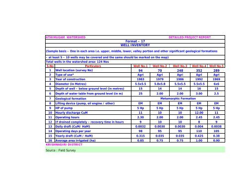
ATHIMUGAM WATERSHED DETAILED PROJECT REPORT<br />
Format <strong>–</strong> 17<br />
WELL INVENTORY<br />
(Sample basis <strong>–</strong> One in each area i.e. upper, middle, lower, valley portion and other significant geological formations<br />
<strong>–</strong> at least 5 <strong>–</strong> 10 wells may be covered and the same should be marked on the map)<br />
Total wells in the <strong>watershed</strong> area: 124 Nos<br />
S.No Particulars Well No.1 Well No.2 Well No.3 Well No.4 Well No.5<br />
1 Well location (survey No) 94 70 248 352 289<br />
2 Type of use* Agri Agri Agri Agri Agri<br />
3 Year of construction 1983 1979 1986 1992 1969<br />
4 Diameter (in Metres) 5.5x5.5 5.8x5.8 5.5x5.5 5.5x5.5 6x6<br />
5 Depth of well <strong>–</strong> below ground level (in metres) 15 14 14 16 15<br />
6 Depth of water table from ground level (in m) 25 2.00 2.00 3.00 2.5<br />
7 Geological formation<br />
Metamorphic Formation<br />
8 Lifting device (pump, oil engine / other) EM EM EM EM EM<br />
9 HP of pump 5 Hp 5 Hp 5 Hp 5 Hp 5 Hp<br />
10 Hourly discharge CuM 11 10 10 12.00 11<br />
11 Operating hours 2.30 2.00 2.00 2.45 2.45<br />
12 If drained completely <strong>–</strong> recovery time in hours 9 10 10 8 9<br />
13 Daily draft (CuM/ HaM) 0.0032 0.0030 0.0030 0.004 0.0038<br />
14 Operating days per year 98 95 95 110 105<br />
15 Yearly draft (CuM / HaM) 0.315 0.035 0.035 0.425 0.38<br />
16 Average area irrigated (ha) 0.85 0.75 0.75 1.00 0.90<br />
KRISHNAGIRI DISTRICT<br />
Source : Field Survey