Good as Gold - Washington Trails Association
Good as Gold - Washington Trails Association
Good as Gold - Washington Trails Association

Create successful ePaper yourself
Turn your PDF publications into a flip-book with our unique Google optimized e-Paper software.
www.wta.org<br />
September 2008 » W<strong>as</strong>hington <strong>Trails</strong><br />
On Trail<br />
Northwest Explorer »<br />
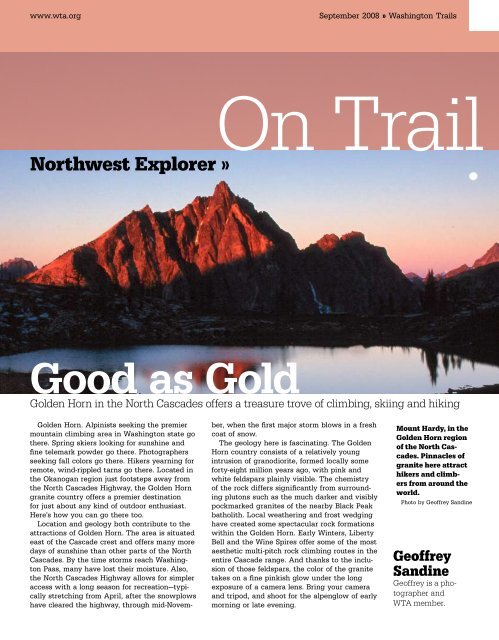
<strong>Good</strong> <strong>as</strong> <strong>Gold</strong><br />
<strong>Gold</strong>en Horn in the North C<strong>as</strong>cades offers a tre<strong>as</strong>ure trove of climbing, skiing and hiking<br />
<strong>Gold</strong>en Horn. Alpinists seeking the premier<br />
mountain climbing area in W<strong>as</strong>hington state go<br />
there. Spring skiers looking for sunshine and<br />
fine telemark powder go there. Photographers<br />
seeking fall colors go there. Hikers yearning for<br />
remote, wind-rippled tarns go there. Located in<br />
the Okanogan region just footsteps away from<br />
the North C<strong>as</strong>cades Highway, the <strong>Gold</strong>en Horn<br />
granite country offers a premier destination<br />
for just about any kind of outdoor enthusi<strong>as</strong>t.<br />
Here’s how you can go there too.<br />
Location and geology both contribute to the<br />
attractions of <strong>Gold</strong>en Horn. The area is situated<br />
e<strong>as</strong>t of the C<strong>as</strong>cade crest and offers many more<br />
days of sunshine than other parts of the North<br />
C<strong>as</strong>cades. By the time storms reach W<strong>as</strong>hington<br />
P<strong>as</strong>s, many have lost their moisture. Also,<br />
the North C<strong>as</strong>cades Highway allows for simpler<br />
access with a long se<strong>as</strong>on for recreation—typically<br />
stretching from April, after the snowplows<br />
have cleared the highway, through mid-Novem-<br />
ber, when the first major storm blows in a fresh<br />
coat of snow.<br />
The geology here is f<strong>as</strong>cinating. The <strong>Gold</strong>en<br />
Horn country consists of a relatively young<br />
intrusion of granodiorite, formed locally some<br />
forty-eight million years ago, with pink and<br />
white feldspars plainly visible. The chemistry<br />
of the rock differs significantly from surrounding<br />
plutons such <strong>as</strong> the much darker and visibly<br />
pockmarked granites of the nearby Black Peak<br />
batholith. Local weathering and frost wedging<br />
have created some spectacular rock formations<br />
within the <strong>Gold</strong>en Horn. Early Winters, Liberty<br />
Bell and the Wine Spires offer some of the most<br />
aesthetic multi-pitch rock climbing routes in the<br />
entire C<strong>as</strong>cade range. And thanks to the inclusion<br />
of those feldspars, the color of the granite<br />
takes on a fine pinkish glow under the long<br />
exposure of a camera lens. Bring your camera<br />
and tripod, and shoot for the alpenglow of early<br />
morning or late evening.<br />
Mount Hardy, in the<br />
<strong>Gold</strong>en Horn region<br />
of the North C<strong>as</strong>cades.<br />
Pinnacles of<br />
granite here attract<br />
hikers and climbers<br />
from around the<br />
world.<br />
Photo by Geoffrey Sandine<br />
Geoffrey<br />
Sandine<br />
Geoffrey is a photographer<br />
and<br />
WTA member.
»On Trail September 2008 » W<strong>as</strong>hington <strong>Trails</strong> www.wta.org<br />
In October, larches<br />
along the Pacific<br />
Crest Trail north of<br />
Rainy P<strong>as</strong>s turn a<br />
brilliant goldenyellow.<br />
The region<br />
w<strong>as</strong> unfortunately<br />
left out of North<br />
C<strong>as</strong>cades National<br />
Park.<br />
Photo by Geoffrey Sandine<br />
On my first visit in 1991, I drove my longsince<br />
retired Datsun LX through a dismal morning<br />
of fog and rain up Highway 20 en route to<br />
the Twisp River. When I arrived at W<strong>as</strong>hington<br />
P<strong>as</strong>s, the showers relented a bit. In brief windows<br />
where the mist parted, a dreamlike city<br />
of rock emerged—the shimmering gold towers<br />
of Burgundy, Chablis and Pernod along with<br />
the immediate sheer face of Liberty Bell. With<br />
all these amazing peaks jutting skyward above<br />
clusters of white pine and hemlock, I knew this<br />
w<strong>as</strong> a place that demanded further exploration.<br />
So where do you begin? First, a mandatory<br />
stroll along the paved overlook trail from the<br />
p<strong>as</strong>s really cannot be beat for views of the big<br />
walls of the Liberty Bell m<strong>as</strong>sif, along with Silverstar<br />
Mountain and the Wine Spires. Or hike<br />
the 5-mile round trip Blue Lake Trail, which<br />
takes you to a tarn at the foot of Liberty Bell.<br />
And, for the adventurous, try the off-trail journey<br />
from the highway’s hairpin turn to Kangaroo<br />
P<strong>as</strong>s, with views of odd, weathered sculptures<br />
like Half Moon and Kangaroo Temple, two<br />
formations that preside over a rugged b<strong>as</strong>in of<br />
polished domes and scree slopes. Midway, you<br />
will p<strong>as</strong>s the remnants of a small wayward<br />
plane and later a shady pond, frozen for much<br />
of the year, before locating a boot path that<br />
<strong>as</strong>cends to the p<strong>as</strong>s.<br />
Pacific Crest Trail aficionados have a great<br />
opportunity in the <strong>Gold</strong>en Horn area. The immaculately<br />
maintained route between Rainy<br />
P<strong>as</strong>s and Harts P<strong>as</strong>s makes for a relatively e<strong>as</strong>y<br />
one-way backpacking trip using two cars—one<br />
at each p<strong>as</strong>s. The tread weaves upward through<br />
pine and larch forests, the latter of which turn<br />
golden in the fall. The trail crosses a perennial<br />
stream after 3 miles, your l<strong>as</strong>t reliable water<br />
for many hours, before reaching Cutthroat P<strong>as</strong>s<br />
around the 5-mile mark. The trail then sidehills<br />
over a crushed gravel bed for several enjoyable<br />
alpine miles, p<strong>as</strong>sing through pockets of<br />
larch and offering vist<strong>as</strong> to a huge panorama<br />
of peaks in all directions. Look for Black Tower<br />
and Silverstar Mountains <strong>as</strong> well <strong>as</strong> the jagged<br />
spires of the Needles. At the 10-mile mark, you<br />
can take an e<strong>as</strong>y side trip to shallow Snowy<br />
Lakes, set in a high b<strong>as</strong>in, or continue on the<br />
PCT for a few more miles and snoop around for<br />
the elusive Nugget Lakes set deep in a forested<br />
vale. At 31 miles, you reach Harts P<strong>as</strong>s, where<br />
your return vehicle awaits.<br />
In spring, telemark skiers head for Silverstar<br />
Mountain. As seen from the W<strong>as</strong>hington P<strong>as</strong>s<br />
overlook, the complex sweep of serpentine buttresses<br />
culminating in sharp pinnacles might<br />
appear daunting, but the glacier on the hidden<br />
backside provides skiers an e<strong>as</strong>y outlet to thousands<br />
of feet of wilderness powder. Access to<br />
the glacier is best achieved by following either<br />
the Silverstar Creek route beginning at the<br />
signed outlet for the creek or the more straightforward<br />
climber’s path that begins around the<br />
widened 5,400-foot mark off Highway 20. If you<br />
choose the climber’s route, then begin by scampering<br />
down a loose boulder field and cross<br />
Willow Creek, always fordable except during a<br />
major spring runoff. On the other side, veer left<br />
and scan for a track leading uphill, which in<br />
short order crests the timbered ridge. The route<br />
becomes more distinct <strong>as</strong> the timber thins but<br />
disappears altogether in the gully that leads<br />
to Burgundy Col. According to Mazama-b<strong>as</strong>ed<br />
mountain guide Larry <strong>Gold</strong>ie, another possible<br />
ski tour would be in the snow bowls under the<br />
shadow of Cutthroat Peak. The paved Cutthroat<br />
Lake trailhead provides a starting point to<br />
these fine runs that don’t require prior mountaineering<br />
experience.<br />
One of the best ways to enjoy the area is to<br />
get in touch with the granite. Literally. <strong>Gold</strong>ie<br />
<strong>as</strong>serts, “The big thing tends to be the high
www.wta.org September 2008 » W<strong>as</strong>hington <strong>Trails</strong> On Trail «<br />
quality of rock climbs, 50 to 60 routes on the<br />
Liberty Bell m<strong>as</strong>sif with dozens of cl<strong>as</strong>sic routes<br />
that offer climbers years of entertainment.”<br />
Further, <strong>Gold</strong>ie says, “It’s some of the best rock<br />
in the mountains in the Northwest.”<br />
For those with rock climbing skills, two<br />
excellent starter routes are both located on the<br />
Liberty Bell m<strong>as</strong>sif. Each is approached from<br />
the popular Blue Lake trailhead. The South<br />
Arete on South Early Winters Spire features two<br />
separate mid-fifth-cl<strong>as</strong>s moves near the beginning<br />
of the climb. Once p<strong>as</strong>t these challenges,<br />
the remaining <strong>as</strong>cent involves scrambling on or<br />
near the crest, requiring perhaps only another<br />
belay or two depending on the climbing party’s<br />
level of experience. At 7,807 feet, the summit<br />
commands views of startling contr<strong>as</strong>ts between<br />
the barren hills of the seldom-explored P<strong>as</strong>ayten<br />
Wilderness in one direction and the ice<br />
giants of the North C<strong>as</strong>cades in the other. Two<br />
ropes are recommended for the rappel down<br />
the lower section of the route.<br />
The Southwest Face route on the Liberty Bell<br />
climb follows in the pioneering footsteps of the<br />
Northwest’s most prolific climber, Fred Beckey,<br />
on superlative rock. While you may share a<br />
ledge with a mountain goat, typically it is<br />
interested in a good salt lick and not you. This<br />
<strong>as</strong>cent initially climbs over a chockstone, or you<br />
may opt to squeeze through a minor hole underneath,<br />
confident your Slim-F<strong>as</strong>t breakf<strong>as</strong>t did<br />
the job. The next pitch tackles a steep winding<br />
chimney in the 5.6 to 5.7 range, followed by<br />
another pitch of mid-fifth-cl<strong>as</strong>s climbing. Your<br />
l<strong>as</strong>t barrier is a friction slab rated at 5.7 but<br />
really nothing more than a bouldering problem,<br />
given the lack of exposure. Then you’re at the<br />
top of Liberty Bell proper. Bring a double rope<br />
for this one <strong>as</strong> well. The descent does not follow<br />
the climbing route but rather takes a more<br />
direct line to the col splitting Liberty Bell and<br />
Concord Tower.<br />
After you have finished a hard day of adventuring,<br />
drop by the Winthrop Brewery, at 155<br />
Riverside Avenue in Wintrhop. You’ll find live<br />
blues on Fridays and a fine porter on tap. It’s a<br />
great place to run into other weekend warriors.<br />
Other places to grab some grub:<br />
Twisp River Pub features hand-crafted ales<br />
and an excellent selection of West Co<strong>as</strong>t wines<br />
plus live blues/jazz/folk music. I recommend the<br />
Thai Peanut Stir Fry. 201 Highway 20, Twisp.<br />
Cinnamon Twisp Bakery. Arrive early for<br />
your Cinnatwist (my wife sets the alarm)! 116 N.<br />
Glover Street, Twisp.<br />
Sun Mountain Lodge A formal dining experience<br />
with views over the Methow. Just follow<br />
Sun Mountain Road from Winthrop to the lodge.<br />
Hike<br />
Details<br />
Rainy P<strong>as</strong>s<br />
to Harts P<strong>as</strong>s<br />
Maps: Green <strong>Trails</strong><br />
49 Mount Logan, 50<br />
W<strong>as</strong>hington P<strong>as</strong>s, 51<br />
Mazama<br />
Guidebook: 100<br />
Hikes in W<strong>as</strong>hington’s<br />
North C<strong>as</strong>cades<br />
National Park Region<br />
by Harvey Manning &<br />
Ira Spring (Mountaineers<br />
Books, 2000).<br />
Mileage: 31 miles<br />
Elevation gain:<br />
2,700 feet to Snowy<br />
Lake<br />
Directions: Drive<br />
the North C<strong>as</strong>cades<br />
Highway (WA 20) to<br />
Rainy P<strong>as</strong>s. The trailhead<br />
is on the north<br />
side of the road,<br />
elevation 4,800 feet.<br />
Left: Libery Bell,<br />
above Rainy P<strong>as</strong>s.<br />
Cimbers flock to the<br />
spires of <strong>Gold</strong>ern<br />
Horn for world-cl<strong>as</strong>s<br />
rock.<br />
Below, Left: Hiker<br />
above Varden Lake.<br />
Whether you’re into<br />
backcountry skiing<br />
or day hiking, the region<br />
north of Rainy<br />
P<strong>as</strong>s is a recreation<br />
paradise.<br />
Photos by Geoffrey Sandine