Le Tour de Mont Blanc - Washington Trails Association
Le Tour de Mont Blanc - Washington Trails Association
Le Tour de Mont Blanc - Washington Trails Association

You also want an ePaper? Increase the reach of your titles
YUMPU automatically turns print PDFs into web optimized ePapers that Google loves.
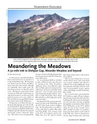
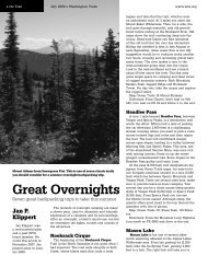
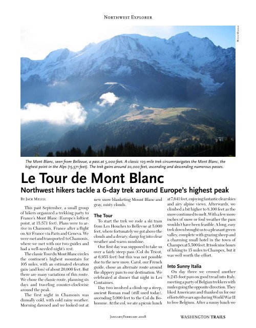
Northwest ExplorerWayne MisenarThe author and her grandson blah blah blahThe <strong>Mont</strong> <strong>Blanc</strong>, seen from Bellevue, a pass at 5,000 feet. A classic 105-mile trek circumnavigates the <strong>Mont</strong> <strong>Blanc</strong>, thehighest point in the Alps (15,571 feet). The trek gains around 20,000 feet, ascending and <strong>de</strong>scending numerous passes.<strong>Le</strong> <strong>Tour</strong> <strong>de</strong> <strong>Mont</strong> <strong>Blanc</strong>Northwest hikers tackle a 6-day trek around Europe’s highest peakBy Jack MelillThis past September, a small groupof hikers organized a trekking party toFrance’s <strong>Mont</strong> <strong>Blanc</strong> (Europe’s loftiestpoint, at 15,571 feet). Plans were to arrivein Chamonix, France after a flighton Air France via Paris and Geneva. Wewere met and transported to Chamonix,where we met with our two gui<strong>de</strong>s andhad a well-nee<strong>de</strong>d night’s rest.The classic <strong>Tour</strong> du <strong>Mont</strong> <strong>Blanc</strong> circlesthe continent’s highest mountain for105 miles, with an estimated elevationgain (and loss) of about 20,000 feet. Butthere are many variations of this route.We chose the classic route, planning sixdays and traveling counter-clockwisearound the peak.The first night in Chamonix wasdismally cold, with cold rainy weather.Morning dawned and we looked out atnew snow blanketing Mount <strong>Blanc</strong> andgray, misty clouds.The <strong>Tour</strong>To start the trek we ro<strong>de</strong> a ski tramfrom <strong>Le</strong>s Houches to Bellevue at 5,000feet, where fortunately we got above theclouds and a dreary, damp fog into clearweather and warm sunshine.Our first day was supposed to take usover a fairly steep pass (Col du Tricot,at 6,955 feet) but this was not possibledue to the new snow. Carol, our Frenchgui<strong>de</strong>, chose an alternate route aroundthe slippery pass to our <strong>de</strong>stination. Wecelebrated at dinner that night in <strong>Le</strong>sContaimes.Day two involved a climb up a steep,ancient Roman road (still used today),ascending 5,000 feet to the Col du Bohomme.At the col, we ate a picnic lunchat 7,641 feet, enjoying fantastic clear skiesand airy alpine views. Afterwards, weclimbed a bit higher to 8,100 feet as thesnow continued to melt. With a few moreinches of snow or foul weather the passwouldn’t have been feasible. A long, easytrek down brought us to a pleasant greenvalley, complete with grazing sheep anda charming small hotel in the town ofChampex at 5,500 feet. It took nine hoursof hiking to 15 miles to Champex, but itwas well worth the effort.Into Sunny ItaliaOn day three we crossed another8,245-foot pass on good tread into Italy,meeting a party of Belgian trekkers withmules going the opposite direction. Theyliked Americans and thanked us for ourefforts 60 years ago during World War IIto free Belgium. After a sunny lunch weJanuary/February 2008WASHINGTON TRAILS
Northwest ExplorerJack Melillhiked past the famous Refugio Elisabettadownward into Italy. The best food ofthe tour was at our small Italian hotel.The beer and wine on the terrace werealso good.On to SwitzerlandRefreshed and rested we tackled thenext high pass, taking us over anotherbor<strong>de</strong>r into Switzerland. En-route ayoung man pushing a mountain bike metus. He planned to ri<strong>de</strong> down the othersi<strong>de</strong>, which seemed to us a dangerousfeat consi<strong>de</strong>ring the high exposure everywhere.We entered Switzerland througha mountain village that was celebrating“bringing in the cows.” Apparently thisis a big occasion as they had bands playing,barbecues going, people paradingin native costume and plenty of cowsmooing. We stayed in an elegant Swisshotel in La Fouly, but sadly one lady inour party became very ill after dining onuncooked freshwater mussels and hadto miss the hike the following day. Sherecovered the next day and was able tofinish the trek.On day five we crossed yet anotherpass (8,300 feet) on what is the roughest,rockiest section of the trail. Evenmules, we were told, have a rough timehere. But we ma<strong>de</strong> it over the pass andgazed down at Martingy, Switzerlandfar below as if we were flying over in anairplane. Then we climbed still higherbefore starting our long <strong>de</strong>scent into theforested valley far below.Return To Chamonix, FranceOur final day we trekked via Coldu Balme (7,188 feet) and back intoFrance. At the pass we were treatedto magnificent view of the mountains,including snow-covered <strong>Mont</strong> <strong>Blanc</strong>before it drifted back into the clouds. Badweather was coming. We walked downthrough the hamlet of Trelechamp beforecontinuing further downward throughArgenterre and back to Chamonix.We celebrated that night with ourgui<strong>de</strong>s Carol and Mark, thankful for asuperb trip and safe return to Chamonix.Dinner was at an local Italian restaurantand after we savored a well-<strong>de</strong>servednight’s rest before our return flights fromGeneva and Paris to Seattle.A Typical DayOn a typical day during the trek, wearose early, had breakfast and startedhiking by 8:30 a.m. About noon we wouldstop and have a picnic lunch composedof cuisine typical in each valley—or aspecial cheese bought by our gui<strong>de</strong>s thatTrekkers pause for a break at La True Pass. The <strong>Tour</strong> <strong>de</strong> <strong>Mont</strong> <strong>Blanc</strong> takes youthrough three countries (Switzerland, Italy and France). At the end of eachrigorous day, you’ll look forward to hotel beds, hot meals and wine on the patio.morning. And always <strong>de</strong>licious, freshlybakedbread. Following lunch and a rest,we would complete the day’s hiking. Weaveraged 10-12 miles per day and 2,000to 3,000 feet of gain and loss over passesand ridges. We always celebrated the endof a day’s hiking with drinks on the patioof each hotel along the route.Jack Melill is a WTA member fromIssaquah. Trip Essentials<strong>Tour</strong> <strong>de</strong> <strong>Mont</strong> <strong>Blanc</strong>Loop length: 105 milesElevation gain: 20,000 feetHiking time: 6 daysIf you plan to do this trip, consi<strong>de</strong>rhiring a gui<strong>de</strong>. They not only speakthe various languages, but also knowthe myriad of trails well (hundreds oftrails are unmarked and unmapped).They check the weather daily andselect the best lodging. They’re alsofun companions and interpret thecultures you encounter along the way.And they add a measure of safetyWe used the Compagnie <strong>de</strong>s Gui<strong>de</strong>sChamonix, the ol<strong>de</strong>st and originalgui<strong>de</strong> service in Chamonix(they got their start in 1821!).For more information, visitwww.chamonix-gui<strong>de</strong>s.com.Before you go, make sure you’rein good shape, for this tour is akinto a trek in Nepal. It’s much moreenjoyable if you’re in good physicalcondition. Have good outdoor equipment,but don’t overpack.For more info, refer to Kev Reynold’sbook The <strong>Tour</strong> of <strong>Mont</strong> <strong>Blanc</strong> ($19.95Cicerone Press, 2007).Watch The WeatherEvery day of our trek was sunny, warmand incredibly clear for us. But youshould always be prepared for badweather in the mountains. The trekcan turn impassable or miserablein rainy or snowy conditions. Ourgui<strong>de</strong>s were constantly checkingweather forecasts. Weather canchange fast in the hills.WASHINGTON TRAILS January/February 2008