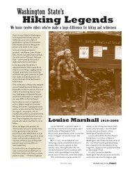
Day Hiking Sun Valley - Washington Trails Association
Day Hiking Sun Valley - Washington Trails Association
Day Hiking Sun Valley - Washington Trails Association

Create successful ePaper yourself
Turn your PDF publications into a flip-book with our unique Google optimized e-Paper software.
www.wta.org<br />
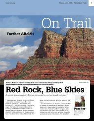
April 2008 » <strong>Washington</strong> <strong>Trails</strong><br />
On Trail<br />
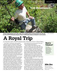
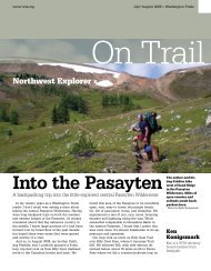
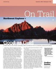
Photo by Herb Stusser<br />
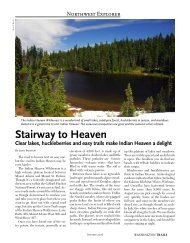
Northwest Explorer »<br />
<strong>Hiking</strong> <strong>Sun</strong> <strong>Valley</strong><br />
Hikes abound in <strong>Sun</strong> <strong>Valley</strong>, Idaho—which is closer than you might think<br />
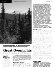
A view of the Sawtooth<br />
Mountains of<br />
Idaho. With trails<br />
close to town, <strong>Sun</strong><br />
<strong>Valley</strong> is a day<br />
hiker’s paradie.<br />
It doesn’t get much better than this. In early<br />
summer, the wonderful combination of incredible<br />
wildflowers, open hillsides leading to<br />
higher snow-covered ridges, and creeks running<br />
full, combine in many easy-access day hikes<br />
literally within minutes of <strong>Sun</strong> <strong>Valley</strong> and the<br />
adjacent town of Ketchum, Idaho. <strong>Sun</strong> <strong>Valley</strong> is<br />
closer than you might think. It’s about a 10-hour<br />
drive from Seattle and considerably less from<br />
Spokane.<br />
Since all of the trailheads start at a minimum<br />
of 6,000 feet, you’re in a high mountain setting<br />
the minute you start walking. It’s a great place<br />
to set up a basecamp in town (that is, with hot<br />
showers, restaurants and a soft bed at night)<br />
and explore the mountains during the day.<br />
This is high desert very much like the eastern<br />
Cascades. My wife and I have been hiking<br />
these trails for over 20 years and still can’t<br />
believe how fast and easy it is to get from <strong>Sun</strong><br />
<strong>Valley</strong> into a true mountain environment. Here<br />
are a few suggestions, most of which are in the<br />
range of three to four hours hiking:<br />
Chocolate Gulch<br />
A beautiful loop that winds up through open<br />
woods to a view over the Smoky Range and<br />
then drops back through barren chocolatecolored<br />
rocks to the Big Wood River and a<br />
return to the trailhead. This hike offers a great<br />
opportunity to see the variety of terrain and<br />
wildflowers typical of the area.<br />
Baker Lake<br />
Drive 25 miles through a valley to a 7,000-foot<br />
trailhead that takes off through open hillsides<br />
on a graded trail to a small, pristine lake (catch<br />
and-release-trout fishing is OK) surrounded by<br />
stark granite cliffs topped off by 11,000-foot<br />
Baker Peak. Afterward, find a wonderful picnic<br />
spot along Baker Creek as you drive back towards<br />
<strong>Sun</strong> <strong>Valley</strong>.<br />
Adams Gulch<br />
This is a very popular network of trails, all<br />
Herb<br />
Stusser<br />
Herb is a WTA Fireside<br />
Circle member<br />
who divides his time<br />
between Seattle and<br />
<strong>Sun</strong> <strong>Valley</strong>.
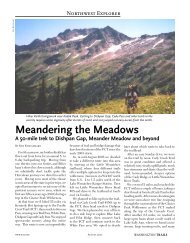
» On Trail April 2008 » <strong>Washington</strong> <strong>Trails</strong> www.wta.org<br />
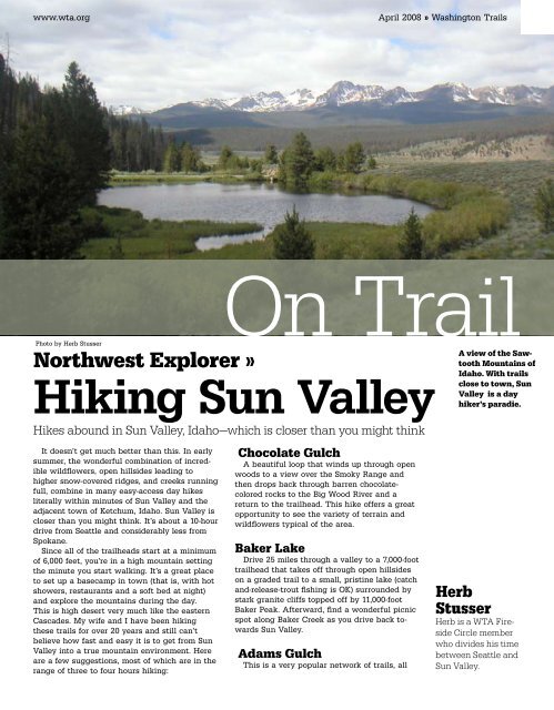
Photo by Herb Stusser<br />
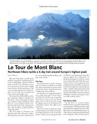
You’re likely to encounter<br />
sheep if you<br />
spend any time hiking<br />
the trails near<br />
<strong>Sun</strong> <strong>Valley</strong>.<br />
Aspens and pines<br />
on trail. The high,<br />
relatively dry climate<br />
is similar to the<br />
mountains around<br />
Spokane.<br />
of which lead up a valley before splitting off<br />
into a variety of loops from 3 miles to 12 miles<br />
in length. Aspen and conifer forests alternate<br />
with open grassy slopes. The August 2007<br />
Castle Rock wildfire roared through some of<br />
these hillsides, and after the snow melts it will<br />
be interesting to see what changes resulted. It<br />
should be great for wildflowers.<br />
Proctor Ridge<br />
This loop takes you up to big views looking<br />
back toward <strong>Sun</strong> <strong>Valley</strong> and Mount Baldy (the<br />
main downhill ski mountain) and then on to an<br />
open ridge that looks toward the Boulder Mountains<br />
in the distance and up the Trail Creek<br />
valley. Bring your camera. Return along a creek<br />
running steeply through an aspen forest.<br />
Greenhorn Gulch<br />
Ten miles south of town is another, wilder<br />
network of trails leading deep into the Smoky<br />
Mountains. You’ll run into fewer people here.<br />
From the hillside near the trailhead we’ve often<br />
seen a mother moose with her calf eating lunch<br />
in the stream below.<br />
Titus Lake<br />
Take a drive 30 miles north of <strong>Sun</strong> <strong>Valley</strong> and<br />
park at the last switchback below Galena Pass<br />
(elevation 8,700 feet). This trail climbs through a<br />
pine forest with increasing views of the distant<br />
Sawtooth Mountains and then bends around<br />
an open ridge from which emerald green Titus<br />
Lake can be spotted far below. Dropping steeply<br />
down to the lake, you’ll find several spots<br />
along the shore to take a dip in the lake or just<br />
chill out. On the drive back, lunch at the beautifully<br />
restored Galena Lodge is a great option.<br />
Excellent trail information and maps are<br />
available at the Ketchum Ranger Station right<br />
in the middle of town, as well as at recreation<br />
stores and lodges throughout the area. You’ll<br />
find a wide array of motels, condo rentals and<br />
campgrounds available in and around <strong>Sun</strong> <strong>Valley</strong>.<br />
A four-wheel-drive vehicle would be helpful<br />
to get to the trailhead for Baker Lake; standard<br />
vehicles are fine for all the other hikes. You may<br />
encounter mountain bikers or horseback riders<br />
on these trails, and dogs are allowed everywhere.<br />
Don’t be surprised if you run into one of<br />
the many large herds of sheep crossing the trail<br />
on their way up to midsummer grazing in the<br />
high meadows.<br />
While all of these trails are usually open<br />
by late May, the extremely heavy 2008 winter<br />
snowpack may delay access to some of them.<br />
Contact the Ketchum Ranger District at (208)<br />
622-5371 for current information. Cross-country<br />
skiing in this same area in the winter is equally<br />
wonderful; watch for ski trail descriptions in a<br />
future issue of <strong>Washington</strong> <strong>Trails</strong>. <br />
Photo by Herb Stusser