FIFTH LINE – 22 SIDEROAD (LIMEHOUSE CA ... - Region of Peel
FIFTH LINE – 22 SIDEROAD (LIMEHOUSE CA ... - Region of Peel
FIFTH LINE – 22 SIDEROAD (LIMEHOUSE CA ... - Region of Peel

Create successful ePaper yourself
Turn your PDF publications into a flip-book with our unique Google optimized e-Paper software.
<strong>FIFTH</strong> <strong>LINE</strong> <strong>–</strong> <strong>22</strong> <strong>SIDEROAD</strong><br />
(<strong>LIMEHOUSE</strong> <strong>CA</strong> AND AREA)<br />
<strong>Region</strong> <strong>of</strong> Halton NAI Area # 7497 Credit Valley<br />
Conservation Authority<br />
Town <strong>of</strong> Halton Hills Size: 176 hectares Watershed: Credit River<br />
Con 5, Lots 21-<strong>22</strong>;<br />
Con 6, Lots 18-<strong>22</strong><br />
Ownership: 58%<br />
private, 42% public<br />
(Credit Valley<br />
Conservation)<br />
Subwatershed: Black<br />
Creek<br />
General Summary<br />
This is a large natural area in relatively good condition and with high biodiversity. A substantial portion<br />
<strong>of</strong> this area is included in Limehouse Conservation Area, receiving moderate passive recreational<br />
use. There is a prominent west-facing escarpment face within the conservation area. Exposed<br />
escarpment cliffs, caves and crevices distinguish this highly aesthetic area. The limestone substrate<br />
supports several rare calciphilic plant species. Black Creek flows through a valley and associated<br />
streams feed into it. The crevices may also provide habitat for bat hibernacula, which bears further<br />
investigation. Vegetation communities are primarily forests with wetlands along Black Creek and<br />
Beeney Creek and in low-lying depressions. The area supports several Species At Risk as well as<br />
provincially and regionally rare species and communities.<br />
The lime kilns here constitute an important historical site.<br />
NAI ELC surveyors inventoried vegetation communities <strong>of</strong> the private, non-conservation area part <strong>of</strong><br />
this natural area (Table 1). In 2002, CVC consultants conducted vegetation community inventories<br />
within the conservation area portion <strong>of</strong> this site. Thus total ELC coverage is 65% <strong>of</strong> the natural area<br />
(determined by access permission). Botanical, breeding bird, butterfly, dragonfly/damselfly and<br />
herpet<strong>of</strong>aunal inventories were conducted in 2003 and 2004 by Halton Natural Areas Inventory<br />
(HNAI) biologists using a methodology similar to that <strong>of</strong> this NAI (Dwyer, 2006). Data from the Halton<br />
Natural Areas Inventory surveys is included in the NAI data set. Additional data was contributed by<br />
various individuals. This combined body <strong>of</strong> knowledge about this natural area is presented here. With<br />
respect to the NAI core inventories (vegetation communities, plants, breeding birds), this area is<br />
considered data-complete. Fish species were inventoried from stations both within the natural area<br />
and from upstream and downstream sampling stations. As there are no barriers between this natural<br />
area and the upstream station and this area and the downstream station, the data collected at these<br />
other stations was extrapolated to this natural area and combined with the data from on-site. An audio<br />
bat inventory was conducted in 2007 on the conservation area property.<br />
Table 1: NAI Field Visits<br />
Visit Date Inventory Type<br />
Unspecified 1995 Fish<br />
24 Oct. 1996 Fish<br />
08 Oct. 1999 Fish<br />
14 Oct. 1999 Fish<br />
30 Aug. 2007 Fauna<br />
31 Aug. 2007 Fauna<br />
03 Sept. 2007 Fauna<br />
Natural Feature Classifications and Planning Areas<br />
This natural area is part <strong>of</strong>:<br />
ESA - Limehouse Cliffs ESA<br />
Niagara Escarpment Plan<br />
Greenbelt Plan<br />
15 July 2008 ELC<br />
16 July 2008 ELC<br />
18 July 2008 ELC<br />
21 July 2008 ELC<br />
21 Aug. 2008 Fish<br />
25 Aug. 2008 Fish<br />
Date <strong>of</strong> this Site Summary: October 2011<br />
1
<strong>FIFTH</strong> <strong>LINE</strong> <strong>–</strong> <strong>22</strong> <strong>SIDEROAD</strong><br />
(<strong>LIMEHOUSE</strong> <strong>CA</strong> AND AREA)<br />
Physical Features<br />
This area is in the Niagara Escarpment physiographic region; characterized by an escarpment that<br />
forms a significant break in the bedrock <strong>of</strong> the region. The escarpment has formed from the differing<br />
erosion rates <strong>of</strong> the bedrock layers, the s<strong>of</strong>ter lower shale layers eroding out from under the hard<br />
dolostone cap rock until portions <strong>of</strong> the cap rock collapse to form a cliff face and talus slope.<br />
There is cliff face and talus slope within the Limehouse Conservation Area part <strong>of</strong> this site. Crevices<br />
are present for a short distance back from the rock face. This area is well-known for Hole-in-the-Wall,<br />
a spot where the Bruce Trail drops down a crevice and between large cliff blocks via a ladder,<br />
exemplifying the escarpment geology <strong>of</strong> the area. The railway cut along the northern border <strong>of</strong> this<br />
site has good exposures <strong>of</strong> Silurian bedrock and is a locally significant earth science Area <strong>of</strong> Scientific<br />
and Natural Interest (ANSI) (Natural Heritage Information Centre, 2010; North-South Environmental,<br />
2004).<br />
Black Creek flows east through this natural area and then turns south at the point where it is joined by<br />
Beeney Creek, a small tributary <strong>of</strong> Black Creek.<br />
Human History<br />
The nearby community <strong>of</strong> Limehouse was first settled in 1820. By the 1840’s limestone quarrying and<br />
“burning” <strong>of</strong> limestone in kilns to make lime, had begun. The Grand Trunk Railway built its line<br />
through Limehouse in 1856 which required 200 workers and their families to settle in the area. Many<br />
<strong>of</strong> these families stayed in the community after the rail line was completed. Besides the lime industry,<br />
there was also a woollen mill, sawmill and a paint factory (using coloured clay from the area) (Gibson,<br />
Undated; Lewis, 2010; McIlveen, 2006).<br />
Parts <strong>of</strong> this natural area were cleared for logging and agricultural purposes. Some <strong>of</strong> the land may<br />
have been grazed.<br />
The lime kilns provided mortar for local buildings from the 1840’s until about 1915. At this time, a<br />
dammed mill pond existed along Black Creek in the north-west corner <strong>of</strong> this natural area and<br />
provided water power to lime industry buildings and to a sawmill. The pond has reverted to marshland<br />
when the dam was broken. A railway once bisected the area below the cliffs and the old railbed is<br />
visible. The remains <strong>of</strong> the lime kilns still exist and a local organization has formed to protect and<br />
restore this historic site. In about 1967, CVC acquired approximately 200 acres to be set aside as<br />
Limehouse Conservation Area.<br />
Limehouse Conservation Area occupies almost half <strong>of</strong> this natural area. It is developed for passive<br />
recreations (hiking) on a network <strong>of</strong> hiking trails, <strong>of</strong> which the Bruce Trail is a part. The conservation<br />
area receives moderate-high use as a section <strong>of</strong> the Bruce Trail and the lime kilns are popular<br />
attractions.<br />
This area is bordered by Fifth Line on the west side, by a railway line to the north and a narrow part<br />
along Black Creek extends to Sixth Line where the creek crosses under the road. Surrounding land<br />
use is agricultural, regenerating old fields, rural residences and recreational manicured area with two<br />
baseball diamonds.<br />
Vegetation Communities<br />
The general community types present are open rock barren (
<strong>FIFTH</strong> <strong>LINE</strong> <strong>–</strong> <strong>22</strong> <strong>SIDEROAD</strong><br />
(<strong>LIMEHOUSE</strong> <strong>CA</strong> AND AREA)<br />
A total <strong>of</strong> 66 vegetation communities <strong>of</strong> 24 different types were mapped over the 65% <strong>of</strong> this area to<br />
which the NAI ELC crew and consultants had access (Table 2). Cliff and talus communities are<br />
regionally rare and although these communities are too small in extent here to be mapped as distinct<br />
communities, they are nonetheless present. The two communities <strong>of</strong> Fresh-Moist Sugar Maple <strong>–</strong><br />
Hemlock Mixed Forest (FOM6-1) are regionally rare.<br />
Table 2: ELC Vegetation Communities<br />
Map Vegetation type Size in % <strong>of</strong> natural<br />
reference *<br />
hectares area<br />
RBO1-1 Dry Carbonate Open Rock Barren<br />
Fresh-Moist Hemlock Coniferous Forest<br />
0.11 0.06<br />
FOC3-1 (2 communities)<br />
Fresh-Moist White Cedar Coniferous Forest<br />
2.35 1.34<br />
FOC4-1 (6 communities) 3.83 2.18<br />
FOD3-1 Dry-Fresh Poplar Deciduous Forest (6 communities) 12.81 7.29<br />
FOD4-1 Dry-Fresh Beech Deciduous Forest<br />
Dry-Fresh White Ash Deciduous Forest<br />
0.56 0.32<br />
FOD4-2 (4 communities)<br />
Dry-Fresh Sugar Maple Deciduous Forest<br />
9.18 5.23<br />
FOD5-1 (7 communities) 19.06 10.85<br />
FOD5-3 Dry-Fresh Sugar Maple <strong>–</strong> Oak Deciduous Forest 1.97 1.12<br />
FOD5-4 Dry-Fresh Sugar Maple <strong>–</strong> Ironwood Deciduous Forest<br />
Dry-Fresh Sugar Maple <strong>–</strong> Paper Birch <strong>–</strong> Poplar<br />
1.47 0.83<br />
FOD5-10 Deciduous Forest (2 communities)<br />
Dry <strong>–</strong> Fresh Sugar Maple <strong>–</strong> Hardwood Deciduous<br />
7.23 4.11<br />
FODM5-11 Forest 2.27 1.29<br />
FOM3-1 Dry-Fresh Hardwood Hemlock Mixed Forest<br />
Dry-Fresh Hemlock <strong>–</strong> Sugar Maple Mixed Forest<br />
1.15 0.66<br />
FOM3-2 (2 communities)<br />
Fresh-Moist Sugar Maple <strong>–</strong> Hemlock Mixed Forest<br />
9.36 5.33<br />
FOM6-1 (2 communities)<br />
Fresh-Moist White Cedar <strong>–</strong> Hardwood Mixed Forest<br />
6.33 3.60<br />
FOM7-2 (2 communities)<br />
Fresh-Moist White Pine <strong>–</strong> Sugar Maple Mixed Forest<br />
1.68 0.96<br />
FOMA-A (2 communities)<br />
Reed-canary Grass Mineral Meadow Marsh<br />
4.02 2.29<br />
MAM2-2 (4 communities) 4.69 2.67<br />
MAM2-10 Forb Mineral Meadow Marsh 0.67 0.38<br />
MAS2-1 Cattail Mineral Shallow Marsh (3 communities) 0.36 0.20<br />
THDM2-11 Hawthorn Deciduous Shrub Thicket 2.23 1.27<br />
CUT1-1 Sumac Cultural Thicket (5 communities) 6.34 3.61<br />
CUS1-1 Hawthorn Cultural Savannah (7 communities) 9.06 5.15<br />
CUW1-A2 White Pine Cultural Woodland 6.34 3.61<br />
CUP3-2 White Pine Coniferous Plantation (3 communities) 4.44 2.53<br />
TOTAL AREA INVENTORIED 117.51<br />
* Note: The map reference code refers to the vegetation type shown on mapping for this area and<br />
also to the Appendix list <strong>of</strong> species typically encountered in this vegetation type.<br />
Date <strong>of</strong> this Site Summary: October 2011<br />
3
<strong>FIFTH</strong> <strong>LINE</strong> <strong>–</strong> <strong>22</strong> <strong>SIDEROAD</strong><br />
(<strong>LIMEHOUSE</strong> <strong>CA</strong> AND AREA)<br />
Species Presence<br />
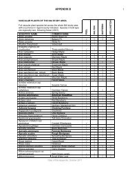
Vascular Plants<br />
Plant biodiversity is high in this area. A total <strong>of</strong> 410 vascular plant species are recorded for this area,<br />
<strong>of</strong> which 291 (71%) are native. One <strong>of</strong> these, Butternut (Juglans cinerea), is Endangered both<br />
nationally and provincially, as well as being provincially rare (S-rank S3?; Table 3). One sapling and<br />
thirteen older Butternut trees were noted, most <strong>of</strong> which are mature trees. Cooper’s Milkvetch<br />
(Astragalus neglectus, S-rank S3) is provincially rare. Twenty-one species are regionally rare (Table<br />
4).<br />
Birds<br />
A total <strong>of</strong> 79 species <strong>of</strong> breeding birds are recorded, <strong>of</strong> which 77 (97%) are native. Four <strong>of</strong> these are<br />
Species At Risk. Bobolink (Dolichonyx oryzivorus) is Threatened nationally and provincially, Goldenwinged<br />
Warbler (Vermivora chrysoptera) and Canada Warbler (Wilsonia Canadensis) are Threatened<br />
nationally and Special Concern provincially and Eastern Meadowlark (Sturnella magna) is Threatened<br />
nationally.<br />
Interior forest habitat is present at this site, supporting eight species <strong>of</strong> area-sensitive forest interior<br />
birds, namely Hairy Woodpecker (Picoides villosus), Pileated Woodpecker (Dryocopus pileatus),<br />
Brown Creeper (Certhia americana), Winter Wren (Troglodytes troglodytes), Red-breasted Nuthatch<br />
(Sitta canadensis), Veery (Catharus fuscescens), Ovenbird (Seiurus aurocapilla) and Scarlet Tanager<br />
(Piranga olivacea). This site also supports three species <strong>of</strong> colonial-nesting birds, Great Blue Heron<br />
(Ardea herodias), Green Heron (Butorides virescens) and Bank Swallow (Riparia riparia), and at least<br />
three raptor species, Broad-winged Hawk (Buteo platypterus), Northern Goshawk (Accipiter gentilis)<br />
and Barred Owl (Strix varia). It supports one species <strong>of</strong> waterfowl, Common Merganser (Mergus<br />
merganser). Early successional habitat here supports six species <strong>of</strong> grassland birds, Bobolink,<br />
Eastern Kingbird (Tyrannus tyrannus), Eastern Meadowlark, Savannah Sparrow (Passerculus<br />
sandwichensis), Vesper Sparrow (Pooecetes gramineus) and Field Sparrow (Spizella pusilla); <strong>of</strong><br />
which three species (Bobolink, Eastern Meadowlark, Savannah Sparrow) are area-sensitive.<br />
Common Raven (Corvus corax) was found here, a species expanding its range south into the Credit<br />
River watershed.<br />
Fish<br />
Eighteen species <strong>of</strong> fish are recorded, <strong>of</strong> which 15 (83%) are native. One <strong>of</strong> these is a 1988 record <strong>of</strong><br />
American Eel (Anguilla rostrata), which is designated Special Concern nationally and Endangered<br />
provincially (Table 3). Three additional species are known from historic records including the<br />
nationally and provincially Endangered Redside Dace (Clinostomus elongates). Redside Dace is also<br />
provincially rare (S-rank S2). This natural area supports coldwater fish communities. Brook Trout<br />
(Salvelinus fontinalis), a coldwater stream species, was found in Black Creek.<br />
Butterflies, Skippers and Moths<br />
A total <strong>of</strong> 23 butterfly, skipper and moth species were recorded, <strong>of</strong> which <strong>22</strong> (96%) are native. On <strong>of</strong><br />
these species, Monarch (Danaus plexippus), is Special Concern nationally and provincially (Table 3).<br />
Some incidental moth species records are collected for this natural area.<br />
Dragonflies and Damselflies<br />
Fourteen dragonfly and damselfly species were recorded, all <strong>of</strong> which are native. Two <strong>of</strong> these,<br />
Swamp Spreadwing (Lestes vigilax) and Sweetflag Spreadwing (Lestes forcipatus) are regionally rare<br />
in Halton <strong>Region</strong> (Dwyer, 2006).<br />
Herpet<strong>of</strong>auna<br />
Thirteen herpet<strong>of</strong>aunal species were recorded, all <strong>of</strong> which are native. One <strong>of</strong> these, Eastern<br />
Milksnake (Lampropeltis triangulum triangulum), is Special Concern nationally and provincially (Table<br />
3). It is also provincially rare (S-rank S3). The remaining herpet<strong>of</strong>auna present here consist <strong>of</strong> six<br />
Date <strong>of</strong> this Site Summary: October 2011<br />
4
<strong>FIFTH</strong> <strong>LINE</strong> <strong>–</strong> <strong>22</strong> <strong>SIDEROAD</strong><br />
(<strong>LIMEHOUSE</strong> <strong>CA</strong> AND AREA)<br />
frog/toad species, two salamander species, one turtle species and three snake species. An historic<br />
record exists <strong>of</strong> a Northern Red-bellied Snake (Storeria occipitomaculata occipitomaculata) (pre-<br />
1990; Macadam, 1999) either in or near this natural area.<br />
Mammals<br />
Sixteen species <strong>of</strong> native, common mammals were detected here, including five bat species based on<br />
an acoustic bat survey. One <strong>of</strong> these, the Northern Long-eared Bat (Myotis septentrionalis), is<br />
provincially rare (S-rank S3?). Undated records exist <strong>of</strong> Mink (Mustela vison), observed within the<br />
conservation area along Black Creek.<br />
Table 3: Designated Species At Risk<br />
Scientific name<br />
BIRDS<br />
Common name COSEWIC COSSARO S rank G rank<br />
Dolichonyx oryzivorus Bobolink THR THR S4B G5<br />
Wilsonia canadensis Canada Warbler<br />
Eastern<br />
THR SC S4B G5<br />
Sturnella magna<br />
Vermivora chrysoptera<br />
BUTTERFLIES<br />
Danaus plexippus Monarch<br />
Meadowlark THR S5B G5<br />
Golden-winged<br />
Warbler THR SC S4B G4<br />
SC SC S2N,S4<br />
B<br />
FISH<br />
Anguilla rostrata American Eel SC END S5 G4<br />
Clinostomus elongatus Redside Dace END END S2 G4<br />
HERPETOFAUNA<br />
Lampropeltis<br />
triangulum triangulum<br />
Eastern<br />
Milksnake SC SC S3 G5T5<br />
Table 4: <strong>Region</strong>ally Rare Vascular Plant Species (Kaiser, 2001)<br />
Scientific name<br />
VASCULAR PLANTS<br />
Common name S rank G rank<br />
Asclepias exaltata Poke Milkweed S4 G5<br />
Asplenium rhizophyllum Walking Fern S4 G5<br />
Asplenium trichomanes ssp.<br />
Maidenhair Spleenwort<br />
trichomanes<br />
subspecies SU G5T5<br />
Astragalus neglectus Cooper's Milkvetch S3 G4<br />
Brachyelytrum erectum Bearded Short-husk S4S5 G5<br />
Carex cryptolepis Northeastern Sedge S4 G4<br />
Carex trisperma var. trisperma Three-seed Sedge subspecies S5 G5T5<br />
Dicentra cucullaria Dutchman’s Breeches S5 G5<br />
Heracleum lanatum Cow-parsnip S5 G5<br />
Hydrophyllum canadense Blunt-leaf Waterleaf S4 G5<br />
Hypericum punctatum Spotted St. John’s-wort S5 G5<br />
Lobelia cardinalis Cardinal Flower S5 G5<br />
Monotropa hypopithys American Pinesap S4 G5<br />
Penstemon hirsutus Hairy Beardtongue S4 G4<br />
Physalis heterophylla Clammy Ground-cherry S4 G5<br />
Polypodium virginianum Rock Polypody S5 G5<br />
Salix nigra Black Willow S4? G5<br />
Date <strong>of</strong> this Site Summary: October 2011<br />
G5<br />
5
<strong>FIFTH</strong> <strong>LINE</strong> <strong>–</strong> <strong>22</strong> <strong>SIDEROAD</strong><br />
(<strong>LIMEHOUSE</strong> <strong>CA</strong> AND AREA)<br />
Symphyotrichum pilosum var. pilosum White Heath Aster variety S5 G5T5<br />
Symphyotrichum urophyllum Arrow-leaved Aster S4 G4G5<br />
Teucrium canadense ssp. canadense Canada Germander S5? G5TR<br />
Triosteum aurantiacum C<strong>of</strong>fee Tinker's-weed S5 G5<br />
Site Condition and Disturbances<br />
This natural area is large, and while a good portion exists as a cohesive core area in and adjacent to<br />
the conservation area, other parts are highly fragmented with patches linked only narrowly. In spite<br />
for the fragmentation, the area still has high biodiversity and high habitat diversity.<br />
Forest age is variable and currently regenerating from historic land clearing for logging, agriculture<br />
and grazing purposes.<br />
Most <strong>of</strong> this area is part <strong>of</strong> Limehouse Conservation Area and this portion has been impacted by<br />
widespread well-marked trails (including the Bruce Trail) and the presence <strong>of</strong> two ball diamonds.<br />
Recreational use is light to moderate, littering is light. Some damage has been sustained by<br />
unauthorized ATV use, fire-pits and camping. Shotgun shells were found. The lime kilns have been<br />
vandalised in the past. Some trampling <strong>of</strong> limestone plants is apparent (North-South Environmental,<br />
2004).<br />
Non-native species are occasional to abundant and widespread. Part <strong>of</strong> this may be due to the area's<br />
history as a busy commercial area with rail lines running through the area as well as nearby. Notable<br />
problematic invasive species present here are Garlic Mustard (Alliaria petiolata), Common Buckthorn<br />
(Rhamnus cathartica), Dame’s Rocket (Hesperis matronalis) and Norway Maple (Acer platanoides).<br />
Remnants <strong>of</strong> early limestone quarry operations exist including lime kilns and a man-made pond.<br />
Some <strong>of</strong> the track-bed from an abandoned rail-way is also visible. An old building foundation, and<br />
discarded farm machinery are also present. Noise from a nearby active quarry can be heard from this<br />
site.<br />
Ecological Features and Functions<br />
All <strong>of</strong> this natural area is part <strong>of</strong> Limehouse Cliffs ESA (valley related).<br />
With forest communities greater than 4 ha, wetlands over 0.5 ha in size and cultural thicket/cultural<br />
savannah totalling over 10 ha, this natural area has the potential to support and sustain biodiversity,<br />
healthy ecosystem functions and to provide long-term resilience for the natural system. The riparian<br />
areas provide a transitional zone between terrestrial and aquatic habitats, helping to maintain the<br />
water quality <strong>of</strong> the creek, and providing a movement corridor for plants and wildlife.<br />
By containing a relatively high number <strong>of</strong> habitat types, this natural area has the potential for high<br />
biodiversity function, particularly for species that require more than one habitat type for their life<br />
needs. This natural area contains regionally rare vegetation communities and thus has the potential<br />
to support additional biodiversity above and beyond that found in common community types.<br />
Linkages to other natural areas exist to the north, upstream along Black Creek, and to the south and<br />
west along Black Creek in the downstream direction. Connectivity also exists between this natural<br />
area and smaller habitat patches to the north across <strong>22</strong> Sideroad and to the west across Fifth Line,<br />
although these connections are interrupted by manicured lots associated with residences. There is a<br />
broad area <strong>of</strong> linkage to with a natural area to the northeast, across Sixth Line. The relatively close<br />
proximity <strong>of</strong> other areas <strong>of</strong> natural habitat creates above-average potential for wildlife movement<br />
between natural areas, species dispersal and recovery from disturbance, creating additional<br />
resilience for the ecosystem.<br />
Date <strong>of</strong> this Site Summary: October 2011<br />
6
<strong>FIFTH</strong> <strong>LINE</strong> <strong>–</strong> <strong>22</strong> <strong>SIDEROAD</strong><br />
(<strong>LIMEHOUSE</strong> <strong>CA</strong> AND AREA)<br />
Black Creek, a major tributary <strong>of</strong> the Credit River, runs through this area and thus supports the<br />
connectivity function <strong>of</strong> the Credit River and its tributaries by providing a natural habitat corridor that<br />
facilitates the cross-regional movement <strong>of</strong> wildlife along this corridor between major provincial<br />
corridors.<br />
Exposed limestone cliffs, caves and crevices are a distinctive character <strong>of</strong> this natural area and<br />
support calciphilic plants.<br />
This site contains regionally rare vegetation communities.<br />
This site supports eight Species At Risk (one plant species, four bird species, one butterfly species,<br />
one fish species, one snake species). The historical data also includes another Species At Risk fish<br />
species in addition to the one noted. Also, four provincially rare species (two plant species, one snake<br />
species, one bat species) occur here as well as 21 regionally rare plant species.<br />
Interior forest habitat is present at this site, supporting eight species <strong>of</strong> area-sensitive forest interior<br />
birds.<br />
This site also supports three colonial-nesting bird species, one species <strong>of</strong> waterfowl, at least three<br />
raptor species and six grassland bird species. Three <strong>of</strong> the grassland bird species are area-sensitive.<br />
Wetlands <strong>of</strong> this area support amphibian breeding.<br />
Based on the above features, this area should be evaluated to determine if significant wildlife habitat<br />
is present in accordance with the Provincial Policy Statement.<br />
Opportunities<br />
As a moderately-used public area, particularly with a network <strong>of</strong> hiking trails throughout, this area<br />
would be a good candidate for invasive species mapping, in order to identify areas where controls<br />
might be affected as well as to monitor the spread <strong>of</strong> these problematic species over time. In<br />
particular, a patch <strong>of</strong> sapling Norway Maples (Acer platanoides) growing within a cultural savannah in<br />
the northwest corner <strong>of</strong> the conservation area might be a good control target. Educational signage at<br />
the conservation area property might help to raise awareness <strong>of</strong> ecosystem issues such as<br />
fragmentation, invasive species and disturbance impacts.<br />
Groundwater seepage was reported in the 1979 ESA report for this natural area and a search is<br />
warranted to determine if it persists. There are several rare species that are associated with<br />
seepages, so identifying areas <strong>of</strong> seepage may help to guide additional surveys for rare species.<br />
Some regenerating old fields could be maintained as meadows by periodic mowing (every 3-5 years)<br />
to prevent succession to treed communities and providing habitat for grassland birds. Mowing should<br />
be done after the young <strong>of</strong> grassland birds have fledged.<br />
The health <strong>of</strong> the Butternut trees present at this site could be assessed by a Butternut Assessor to<br />
determine whether any might be candidates for inclusion in the Butternut recovery program.<br />
Opportunities exist to enhance linkages with nearby natural habitat patches, including support for<br />
landowners to increase the width <strong>of</strong> wildlife movement corridors by planting native trees and shrubs.<br />
Mink are known from this area and a targeted search might reveal their den sites, considered to be<br />
significant wildlife habitat.<br />
Date <strong>of</strong> this Site Summary: October 2011<br />
7
<strong>FIFTH</strong> <strong>LINE</strong> <strong>–</strong> <strong>22</strong> <strong>SIDEROAD</strong><br />
(<strong>LIMEHOUSE</strong> <strong>CA</strong> AND AREA)<br />
This natural area contains seven mature forest communities which should be checked for old-growth<br />
forest characteristics.<br />
The geology <strong>of</strong> this site allows for the possibility <strong>of</strong> bat hibernacula. With hibernating species detected<br />
at this site in late summer, additional surveys targeted for locating hibernacula are warranted.<br />
Literature Cited<br />
Dwyer, J. Halton Natural Areas Inventory. 2006. 2 volumes. Volume 1: Site Summaries. Volume 2: Species Checklists. ISBN<br />
0-9732488-6-6, 0-9732488-7-4. Self-published.<br />
Gibson, C. Undated. Limehouse: A Haven from the World. Tackaberry Times. Available at http://www.tackaberrytimes.com/<br />
Last Accessed 16 December 2010.<br />
Lewis, W. 2010. The Historic Village <strong>of</strong> Limehouse. Esquesing Historical Society. Available at<br />
http://www.esquesinghistoricalsociety.ca/ Last Accessed 16 December 2010.<br />
Macadam, L. 1999. The Herpet<strong>of</strong>auna Atlas for the Halton <strong>Region</strong>. Halton/North <strong>Peel</strong> Naturalist Club, Georgetown, ON.<br />
McIlveen, W.D. 2006. Ghost Ponds <strong>of</strong> North Halton. The Esquesing, Halton North <strong>Peel</strong> Naturalist Club newsletter.<br />
September-October 2006.<br />
Natural Heritage Information Centre. 2010. Natural Areas Reports: Limestone Cliffs and Woods. Area 9496. Available at<br />
http://biodiversityexplorer.mnr.gov.on.ca/ Last Accessed 06 December, 2010.<br />
North-South Environmental Inc. January 2003, Revised and Updated Information March 2004. Limehouse Conservation<br />
Area Ecological Background Report. Prepared for Credit Valley Conservation. Campbellville, ON.<br />
Date <strong>of</strong> this Site Summary: October 2011<br />
8
<strong>FIFTH</strong> <strong>LINE</strong> <strong>–</strong> <strong>22</strong> <strong>SIDEROAD</strong><br />
(<strong>LIMEHOUSE</strong> <strong>CA</strong> AND AREA)<br />
Date <strong>of</strong> this Site Summary: October 2011<br />
9
<strong>FIFTH</strong> <strong>LINE</strong> <strong>–</strong> <strong>22</strong> <strong>SIDEROAD</strong><br />
(<strong>LIMEHOUSE</strong> <strong>CA</strong> AND AREA)<br />
Date <strong>of</strong> this Site Summary: October 2011<br />
10
<strong>FIFTH</strong> <strong>LINE</strong> <strong>–</strong> <strong>22</strong> <strong>SIDEROAD</strong><br />
(<strong>LIMEHOUSE</strong> <strong>CA</strong> AND AREA)<br />
Date <strong>of</strong> this Site Summary: October 2011<br />
11