Analysis of the Durrand Glacier Avalanche Accident
Analysis of the Durrand Glacier Avalanche Accident
Analysis of the Durrand Glacier Avalanche Accident

You also want an ePaper? Increase the reach of your titles
YUMPU automatically turns print PDFs into web optimized ePapers that Google loves.
<strong>Durrand</strong> <strong>Avalanche</strong> Report page 9<br />
5. Finally, <strong>the</strong>re is no indication in ei<strong>the</strong>r <strong>the</strong> Coroner’s or Larry Stanier’s report to <strong>the</strong> Coroner<br />
<strong>of</strong> whe<strong>the</strong>r <strong>the</strong> guides at <strong>Durrand</strong> discussed snow conditions and stability with o<strong>the</strong>r nearby<br />
operations, such as neighbouring Selkirk Tangiers Heli-skiing, and how <strong>the</strong>ir risk<br />
management and approach to <strong>the</strong> hazard differed from <strong>the</strong>se o<strong>the</strong>r operations.<br />
I. Chronology <strong>of</strong> events on January 20, 2003<br />
1. At about 8 am on January 20, 2003, two groups <strong>of</strong> skiers (12 led by Ruedi Beglinger, and a<br />
second group <strong>of</strong> 7 skiers led by assistant guide Ken Wylie), left <strong>the</strong> <strong>Durrand</strong> Chalet (1940 m<br />
elevation) and headed north down into <strong>the</strong> headwaters <strong>of</strong> Cairns Creek.<br />
2. There is no indication in ei<strong>the</strong>r <strong>the</strong> Coroner’s Inquiry report or Larry Stanier’s report to <strong>the</strong><br />
Coroner <strong>of</strong> whe<strong>the</strong>r <strong>the</strong> guides checked <strong>the</strong> avalanche transceivers <strong>of</strong> <strong>the</strong>ir guests before<br />
leaving, and what, if anything was done to provide <strong>the</strong>m with instructions in what to do if an<br />
avalanche occurred, and how, if necessary, to carry out an avalanche rescue, especially<br />
one involving multiple burials.<br />
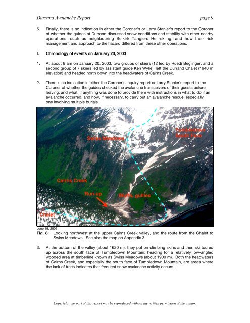
Chalet<br />
Cairns Creek<br />
Swiss Meadows<br />
Run-up<br />
Bluffs, gullies<br />
Tumbledown<br />
South Face<br />
June 19, 2003<br />
Fig. 8: Looking northwest at <strong>the</strong> upper Cairns Creek valley, and <strong>the</strong> route from <strong>the</strong> Chalet to<br />
Swiss Meadows. See also <strong>the</strong> map on Appendix 3.<br />
3. At <strong>the</strong> bottom <strong>of</strong> <strong>the</strong> valley (about 1620 m), <strong>the</strong>y put on climbing skins and <strong>the</strong>n ski toured<br />
up across <strong>the</strong> south face <strong>of</strong> Tumbledown Mountain, heading for a relatively low-angled<br />
wooded area at timberline known as Swiss Meadows (about 1900 m). Both <strong>the</strong> headwaters<br />
<strong>of</strong> Cairns Creek, and especially <strong>the</strong> south face <strong>of</strong> Tumbledown Mountain, are areas where<br />
<strong>the</strong> lack <strong>of</strong> trees indicates that frequent snow avalanche activity occurs.<br />
Copyright: no part <strong>of</strong> this report may be reproduced without <strong>the</strong> written permission <strong>of</strong> <strong>the</strong> author.