Analysis of the Durrand Glacier Avalanche Accident
Analysis of the Durrand Glacier Avalanche Accident
Analysis of the Durrand Glacier Avalanche Accident

You also want an ePaper? Increase the reach of your titles
YUMPU automatically turns print PDFs into web optimized ePapers that Google loves.
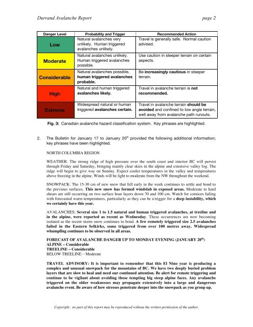
<strong>Durrand</strong> <strong>Avalanche</strong> Report page 2<br />
Danger Level Probability and Trigger Recommended Action<br />
Low<br />
Moderate<br />
Considerable<br />
High<br />
Extreme<br />
Natural avalanches very<br />
unlikely. Human triggered<br />
avalanches unlikely.<br />
Natural avalanches unlikely.<br />
Human triggered avalanches<br />
possible.<br />
Natural avalanches possible,<br />
human triggered avalanches<br />
probable.<br />
Natural and human triggered<br />
avalanches likely.<br />
Widespread natural or human<br />
triggered avalanches certain.<br />
Travel is generally safe. Normal caution<br />
advised.<br />
Use caution in steeper terrain on certain<br />
aspects.<br />
Be increasingly cautious in steeper<br />
terrain.<br />
Travel in avalanche terrain is not<br />
recommended.<br />
Travel in avalanche terrain should be<br />
avoided and confined to low angle terrain,<br />
well away from avalanche path runouts.<br />
Fig. 3: Canadian avalanche hazard classification system. Key phrases are highlighted.<br />
2. The Bulletin for January 17 to January 20 th provided <strong>the</strong> following additional information;<br />
key phrases have been highlighted.<br />
NORTH COLUMBIA REGION<br />
WEATHER: The strong ridge <strong>of</strong> high pressure over <strong>the</strong> south coast and interior BC will persist<br />
through Friday and Saturday, bringing mainly clear skies in <strong>the</strong> alpine and extensive valley fog. The<br />
ridge will begin to give way on Sunday. Expect cooler temperatures in <strong>the</strong> valley and temperatures<br />
above freezing in <strong>the</strong> alpine. Winds will be light to moderate from <strong>the</strong> NW throughout <strong>the</strong> weekend.<br />
SNOWPACK: The 15-30 cm <strong>of</strong> new snow that fell early in <strong>the</strong> week continues to settle and bond to<br />
<strong>the</strong> previous surfaces. This new snow has formed windslab in exposed areas. Moderate to hard<br />
shears are still occurring on two surface hoar layers down 70 and 100 cm. Watch for cornices failing<br />
with forecasted warm temperatures, particularly as <strong>the</strong>y can be a trigger for a deep instability, which<br />
we certainly have this year.<br />
AVALANCHES: Several size 1 to 1.5 natural and human triggered avalanches, at treeline and<br />
in <strong>the</strong> alpine, were reported as recent as Wednesday. These occurrences are now becoming<br />
isolated as <strong>the</strong> recent storm snow continues to bond. A few remotely triggered size 2.5 avalanches<br />
failed in <strong>the</strong> Eastern Selkirks, some triggered from over 100 metres away. Widespread<br />
whumpfing continues to be observed in all areas.<br />
FORECAST OF AVALANCHE DANGER UP TO MONDAY EVENING (JANUARY 20 th )<br />
ALPINE – Considerable<br />
TREELINE – Considerable<br />
BELOW TREELINE – Moderate<br />
TRAVEL ADVISORY: It is important to remember that this El Nino year is producing a<br />
complex and unusual snowpack for <strong>the</strong> mountains <strong>of</strong> BC. We have two deeply buried problem<br />
layers that are slow to heal and need our continued attention. Be alert for remote triggering and<br />
continue to be vigilant about avoiding those tempting big steep alpine faces. Any avalanche<br />
triggered on <strong>the</strong> older weaknesses may propagate extensively into a large and dangerous<br />
avalanche event. Be aware <strong>of</strong> how stresses penetrate deeper into <strong>the</strong> snowpack as you group up.<br />
Copyright: no part <strong>of</strong> this report may be reproduced without <strong>the</strong> written permission <strong>of</strong> <strong>the</strong> author.