Analysis of the Durrand Glacier Avalanche Accident
Analysis of the Durrand Glacier Avalanche Accident
Analysis of the Durrand Glacier Avalanche Accident

Create successful ePaper yourself
Turn your PDF publications into a flip-book with our unique Google optimized e-Paper software.
<strong>Durrand</strong> <strong>Avalanche</strong> Report page 11<br />
5. One <strong>of</strong> <strong>the</strong> skiers reported that <strong>the</strong> group had to cross debris left by a recent avalanche on<br />
<strong>the</strong> ski tour up to Swiss Meadows. Such a slide would carry anyone trapped in it over<br />
bluffs or through gullies, and <strong>the</strong>n into <strong>the</strong> narrow valley <strong>of</strong> Cairns Creek.<br />
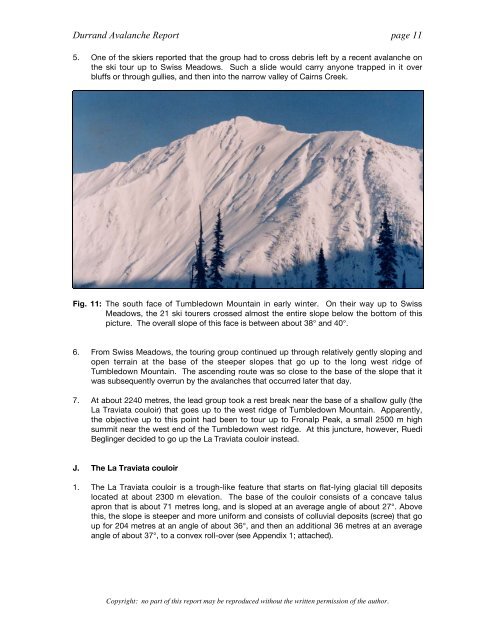
Fig. 11: The south face <strong>of</strong> Tumbledown Mountain in early winter. On <strong>the</strong>ir way up to Swiss<br />
Meadows, <strong>the</strong> 21 ski tourers crossed almost <strong>the</strong> entire slope below <strong>the</strong> bottom <strong>of</strong> this<br />
picture. The overall slope <strong>of</strong> this face is between about 38° and 40°.<br />
6. From Swiss Meadows, <strong>the</strong> touring group continued up through relatively gently sloping and<br />
open terrain at <strong>the</strong> base <strong>of</strong> <strong>the</strong> steeper slopes that go up to <strong>the</strong> long west ridge <strong>of</strong><br />
Tumbledown Mountain. The ascending route was so close to <strong>the</strong> base <strong>of</strong> <strong>the</strong> slope that it<br />
was subsequently overrun by <strong>the</strong> avalanches that occurred later that day.<br />
7. At about 2240 metres, <strong>the</strong> lead group took a rest break near <strong>the</strong> base <strong>of</strong> a shallow gully (<strong>the</strong><br />
La Traviata couloir) that goes up to <strong>the</strong> west ridge <strong>of</strong> Tumbledown Mountain. Apparently,<br />
<strong>the</strong> objective up to this point had been to tour up to Fronalp Peak, a small 2500 m high<br />
summit near <strong>the</strong> west end <strong>of</strong> <strong>the</strong> Tumbledown west ridge. At this juncture, however, Ruedi<br />
Beglinger decided to go up <strong>the</strong> La Traviata couloir instead.<br />
J. The La Traviata couloir<br />
1. The La Traviata couloir is a trough-like feature that starts on flat-lying glacial till deposits<br />
located at about 2300 m elevation. The base <strong>of</strong> <strong>the</strong> couloir consists <strong>of</strong> a concave talus<br />
apron that is about 71 metres long, and is sloped at an average angle <strong>of</strong> about 27°. Above<br />
this, <strong>the</strong> slope is steeper and more uniform and consists <strong>of</strong> colluvial deposits (scree) that go<br />
up for 204 metres at an angle <strong>of</strong> about 36°, and <strong>the</strong>n an additional 36 metres at an average<br />
angle <strong>of</strong> about 37°, to a convex roll-over (see Appendix 1; attached).<br />
Copyright: no part <strong>of</strong> this report may be reproduced without <strong>the</strong> written permission <strong>of</strong> <strong>the</strong> author.