AONB LCAR S1 P1-10 FINAL - the Cotswolds Area of Outstanding ...
AONB LCAR S1 P1-10 FINAL - the Cotswolds Area of Outstanding ...
AONB LCAR S1 P1-10 FINAL - the Cotswolds Area of Outstanding ...

Create successful ePaper yourself
Turn your PDF publications into a flip-book with our unique Google optimized e-Paper software.
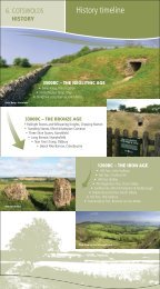
2 Evolution <strong>of</strong> <strong>the</strong> Landscape<br />
<strong>the</strong> ‘English Places Names’ definition, however, <strong>the</strong> name<br />
Cotswold is thought to date to <strong>the</strong> early Anglo Saxon<br />
period, and is understood to refer to an area <strong>of</strong> wooded<br />
land held by <strong>the</strong> Saxon Cot. He also held a valley (dean),<br />
which has subsequently become known as Cutsdean. In<br />
<strong>the</strong> later Anglo Saxon period ‘wold’ changed its meaning<br />
and came to describe treeless upland pasture. Gradually<br />
<strong>the</strong> term Cotswold became an appropriate name for<br />
landscapes that stretched over much <strong>of</strong> <strong>the</strong> uplands and<br />
indeed in subsequent centuries, <strong>the</strong> term Coteswaud,<br />
Coteswold and Cottyswolde were all used to describe<br />
areas <strong>of</strong> land in <strong>the</strong> <strong>AONB</strong> and much later still began<br />
to be used to describe a much wider geographical area.<br />
The first known use <strong>of</strong> <strong>the</strong> term is attributed to Giraldus<br />
Cambrensis (1146-1223) a cleric and writer who used<br />
<strong>the</strong> term ‘Montana de Codesuualt’ to describe <strong>the</strong> land<br />
between Blockley and Evesham. 16<br />
The uplands had been extensively grazed and settled since<br />
<strong>the</strong> Neolithic. Evidence suggests, however, that from <strong>the</strong><br />
8th century, sheep became increasingly important. Downs<br />
are <strong>the</strong> most important indicators <strong>of</strong> sheep husbandry; <strong>the</strong><br />
Anglo Saxon term ‘Dun’ referring to hill pasture. Therefore,<br />
many villages had <strong>the</strong>ir downs, that were unfenced<br />
uplands, shared by villagers. Names such as Hawling<br />
Down, Northleach Down and Blockley Downs indicate <strong>the</strong>ir<br />
presence, although many were ploughed up and enclosed<br />
during <strong>the</strong> late 18th and early 19th centuries.<br />
Almost all traces <strong>of</strong> Saxon settlements has been removed<br />
from <strong>the</strong> landscape or covered by subsequent development.<br />
The ‘headland’, a bank that formed at <strong>the</strong> edge <strong>of</strong> village<br />
fields, is taken as an indication that where present, many <strong>of</strong><br />
<strong>the</strong> fields that contain ridge and furrow in <strong>the</strong> vale at <strong>the</strong><br />
foot <strong>of</strong> <strong>the</strong> scarp could have originated in <strong>the</strong> Saxon period.<br />
2.8.8<br />
Medieval Period (AD <strong>10</strong>66 – AD 1500)<br />
Following <strong>the</strong> defeat <strong>of</strong> Harold at Hastings in <strong>10</strong>66 William<br />
<strong>the</strong> Conqueror ei<strong>the</strong>r killed or dispossessed <strong>the</strong> majority <strong>of</strong><br />
English earls and thanes and allocated confiscated lands to<br />
his followers. This was to ensure <strong>the</strong> security <strong>of</strong> this part<br />
<strong>of</strong> <strong>the</strong> kingdom, and was part <strong>of</strong> a wider policy <strong>of</strong> creating<br />
powerful lordships that could provide money and military<br />
support to defend against uprisings and invaders, and<br />
maintain order over <strong>the</strong> local population.<br />
To achieve this, castles were built at a number <strong>of</strong> strategic<br />
locations. The early types were Motte and Bailey castles<br />
positioned to control important routes. There are some<br />
16. An<strong>the</strong>a Jones (1994) The <strong>Cotswolds</strong><br />
26<br />
<strong>Cotswolds</strong> <strong>AONB</strong> Partnership<br />
ST MICHAELS CHURCH IN DUNTISBOURNE ROUS IS OF NORMAN<br />
CONSTRUCTION ALTHOUGH SOME EVIDENCE OF SAXON<br />
ARCHITECTURE REMAINS<br />
good examples in <strong>the</strong> <strong>AONB</strong> including castles at Ascottunder-Wychwood,<br />
Brailes and Ratley, where impressive<br />
earthworks can still be seen. Where a more durable castle<br />
and a potent symbol <strong>of</strong> authority was required, strongholds<br />
were rebuilt <strong>of</strong> stone as at Castle Combe. This hilltop was<br />
also <strong>the</strong> site <strong>of</strong> an Iron Age Promontory fort, which was<br />
occupied between <strong>10</strong>0 BC, and AD50. It was also later<br />
re-occupied by <strong>the</strong> Saxons at some time before 600 AD.<br />
O<strong>the</strong>r former stone castle sites have been identified<br />
at Beverstone and Brimpsfield. Both were destroyed by<br />
Edward II’s army, which was instructed to ensure that<br />
“not one stone should stand upon ano<strong>the</strong>r”.<br />
The Normans were also great church builders (and rebuilders)<br />
and numerous churches in <strong>the</strong> <strong>AONB</strong> contain<br />
Norman architecture. Village churches were also built or<br />
rebuilt on a grander scale. St. Johns at Elkstone is noted<br />
for its Norman architecture.<br />
While holding court at nearby Gloucester in <strong>the</strong> winter<br />
<strong>of</strong> <strong>10</strong>85, William established <strong>the</strong> concept <strong>of</strong> <strong>the</strong> Domesday<br />
Book, <strong>the</strong> particulars <strong>of</strong> which provide an invaluable<br />
glimpse <strong>of</strong> <strong>the</strong> contemporary landscape.<br />
For example it has been estimated that at <strong>the</strong> start <strong>of</strong> <strong>the</strong><br />
Norman period arable production was prevalent and may<br />
have extended to up to two-thirds <strong>of</strong> <strong>the</strong> land surface.<br />
Up to half <strong>of</strong> <strong>the</strong> arable land would have been left fallow,<br />
grazed by villagers’ animals partly in order to restore <strong>the</strong><br />
soil’s fertility. The summer scene would <strong>the</strong>refore have been<br />
a patchwork <strong>of</strong> browns and greens with sweeps <strong>of</strong> yellow<br />
where cornfields were ripening. Open areas would have<br />
been interspersed with woodland. There would have been<br />
few large woodlands in <strong>the</strong> <strong>Cotswolds</strong> except those clinging<br />
to <strong>the</strong> steep, uncultivable slopes along <strong>the</strong> escarpment and<br />
within valleys. Smaller copses and woodland would,<br />
however, have been located throughout <strong>the</strong> landscape<br />
and provided valuable timber for buildings and fuel.