AONB LCAR S1 P1-10 FINAL - the Cotswolds Area of Outstanding ...
AONB LCAR S1 P1-10 FINAL - the Cotswolds Area of Outstanding ...
AONB LCAR S1 P1-10 FINAL - the Cotswolds Area of Outstanding ...

You also want an ePaper? Increase the reach of your titles
YUMPU automatically turns print PDFs into web optimized ePapers that Google loves.
2 Evolution <strong>of</strong> <strong>the</strong> Landscape<br />
2.1<br />
Introduction<br />
The intricate interplay <strong>of</strong> numerous physical and human influences has shaped <strong>the</strong><br />
landscape as it is experienced today. An understanding <strong>of</strong> <strong>the</strong>se influences is central<br />
to <strong>the</strong> assessment process and provides a sound basis on which to define and describe<br />
landscape character.<br />
PHYSICAL INFLUENCES<br />
2.2<br />
Geology 4,5<br />
2.2.1<br />
Introduction<br />
The geological structure <strong>of</strong> <strong>the</strong> <strong>Cotswolds</strong>, and <strong>the</strong><br />
juxtaposition and succession <strong>of</strong> rocks, is fundamental<br />
to <strong>the</strong> form and structure <strong>of</strong> <strong>the</strong> landscape. While <strong>the</strong><br />
underlying solid geology is responsible for <strong>the</strong> principal<br />
pattern and elevation <strong>of</strong> <strong>the</strong> landform, it is <strong>the</strong> differential<br />
responses <strong>of</strong> <strong>the</strong> various rock strata to <strong>the</strong> effects <strong>of</strong><br />
erosion and wea<strong>the</strong>ring processes that have altered <strong>the</strong><br />
form <strong>of</strong> <strong>the</strong> landscape, influencing drainage and soils, and<br />
in turn <strong>the</strong> subsequent patterns <strong>of</strong> land cover and land<br />
use. The deposition <strong>of</strong> material during <strong>the</strong> most recent<br />
Quaternary era has also been important in moulding and<br />
modifying landform patterns.<br />
A simplified geological map illustrating <strong>the</strong> general pattern<br />
<strong>of</strong> solid rocks and drift deposits within <strong>the</strong> <strong>AONB</strong> is shown<br />
on Figure 6.<br />
The geological structure <strong>of</strong> <strong>the</strong> <strong>Cotswolds</strong> is relatively<br />
simple and consists <strong>of</strong> bands <strong>of</strong> clay, sand and limestone<br />
superimposed on one ano<strong>the</strong>r and gently tilted in Tertiary<br />
times. Jurassic Limestones have had <strong>the</strong> most significant<br />
influence on <strong>the</strong> form <strong>of</strong> <strong>the</strong> landscape and indeed <strong>the</strong><br />
area represents one <strong>of</strong> <strong>the</strong> best-known sections <strong>of</strong> <strong>the</strong><br />
outcrop <strong>of</strong> Oolitic Limestone that extends across England<br />
from Lyme Bay in Dorset to <strong>the</strong> North Sea coast.<br />
Whilst at a superficial level, <strong>the</strong> <strong>Cotswolds</strong> might be seen<br />
as a contiguous unit <strong>of</strong> broadly similar character, local<br />
variations have had a significant impact on <strong>the</strong> landscape<br />
and local landscape character. These are discussed in<br />
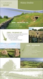
greater detail in Section 3 for each <strong>of</strong> <strong>the</strong> 19 landscape<br />
character type descriptions. An introduction to <strong>the</strong><br />
geological framework within <strong>the</strong> <strong>AONB</strong> follows.<br />
12<br />
<strong>Cotswolds</strong> <strong>AONB</strong> Partnership<br />
2.2.2<br />
Jurassic Geology<br />
Rocks deposited during <strong>the</strong> Jurassic period underlie <strong>the</strong><br />
majority <strong>of</strong> <strong>the</strong> <strong>Cotswolds</strong> <strong>AONB</strong>. These were laid down<br />
between 135 and 180 million years ago at a time when<br />
<strong>the</strong> area that is now <strong>the</strong> centre <strong>of</strong> England was submerged<br />
beneath a vast but relatively shallow ocean. The ocean<br />
was surrounded by islands, areas <strong>of</strong> land that now<br />
comprise uplands in Cornwall, Devon and <strong>the</strong> Mendips.<br />
To <strong>the</strong> south-east stretched a landmass linking <strong>the</strong> London<br />
area and East Anglia to a large continent (Hyrcinia). The<br />
sedimentary rocks <strong>of</strong> <strong>the</strong> <strong>Cotswolds</strong> were formed in <strong>the</strong><br />
subtropical shallows that existed on <strong>the</strong> fringes <strong>of</strong> this<br />
ocean, with mud, pebbles, broken shells and fossilised<br />
tissue laid down to form an elaborate series <strong>of</strong> clays and<br />
limestone.<br />
Three distinct divisions within <strong>the</strong> Jurassic are represented<br />
within <strong>the</strong> <strong>Cotswolds</strong>, each resulting in contrasting<br />
landforms and landscape features. The oldest rocks<br />
comprise <strong>the</strong> Lower Jurassic Lias Group (clays, siltstones,<br />
shales and limestones), followed by <strong>the</strong> Middle Jurassic<br />
Inferior Oolite (limestones, clays and sandstones), and<br />
finally <strong>the</strong> Great Oolite (comprising mainly limestones and<br />
occasional musdstones), culminating in <strong>the</strong> Cornbrash<br />
Formation.<br />
Lower Jurassic: Lias Group<br />
In 1999 a re-classification <strong>of</strong> <strong>the</strong> Lower Jurassic was<br />
published in a British Geological Survey Research Report 6 ,<br />
and <strong>the</strong> previously familiar terms <strong>of</strong> Lower, Middle and<br />
Upper Lias have now been replaced by <strong>the</strong> Lias Group,<br />
and described in terms <strong>of</strong> lithostratigraphical formations.<br />
4. William Dreghorn (1967) Geology Explained in <strong>the</strong> Severn Vale and<br />
<strong>Cotswolds</strong><br />
5. Ed. Charles and Alice Mary Hadfield (1973) The <strong>Cotswolds</strong>: A New Study<br />
6. Cox, Sumbler and Ivimey-Cook (1999) A formational Framework for<br />
<strong>the</strong> Lower Jurassic <strong>of</strong> England and Wales (onshore area), British<br />
Geological Survey Research Report No RR/99/01