102600 Minutes Planning Commission - Nashville.gov
102600 Minutes Planning Commission - Nashville.gov
102600 Minutes Planning Commission - Nashville.gov

You also want an ePaper? Increase the reach of your titles
YUMPU automatically turns print PDFs into web optimized ePapers that Google loves.
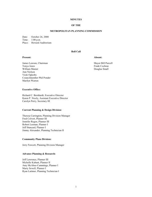
Date: October 26, 2000<br />
Time: 1:00 p.m.<br />
Place: Howard Auditorium<br />
MINUTES<br />
OF THE<br />
METROPOLITAN PLANNING COMMISSION<br />
Roll Call<br />
Present: Absent:<br />
James Lawson, Chairman Mayor Bill Purcell<br />
Tonya Jones Frank Cochran<br />
William Manier Douglas Small<br />
Ann Nielson<br />
Vicki Oglesby<br />
Councilmember Phil Ponder<br />
Marilyn Warren<br />
Executive Office:<br />
Richard C. Bernhardt, Executive Director<br />
Karen P. Nicely, Assistant Executive Director<br />
Carolyn Perry, Secretary III<br />
Current <strong>Planning</strong> & Design Division:<br />
Theresa Carrington, <strong>Planning</strong> Division Manager<br />
Fred Colvert, Planner III<br />
Jennifer Regen, Planner III<br />
Robert Leeman, Planner I<br />
Jeff Stuncard, Planner I<br />
Jimmy Alexander, <strong>Planning</strong> Technician II<br />
Community Plans Division:<br />
Jerry Fawcett, <strong>Planning</strong> Division Manager<br />
Advance <strong>Planning</strong> & Research:<br />
Jeff Lawrence, Planner III<br />
Michelle Kubant, Planner II<br />
Amy McAbee-Cummings, Planner I<br />
Marty Sewell, Planner I<br />
Ryan Latimer, <strong>Planning</strong> Technician I<br />
1
Others Present:<br />
Jim Armstrong, Public Works<br />
Brook Fox, Legal Department<br />
Chris Koster, Mayor's Office<br />
Mark Macy, Public Works<br />
Chairman Lawson called the meeting to order.<br />
Ms. Carrington introduced new staff members, Brooks Fox, with the Legal Department and Fred Colvert,<br />
Subdivision Section Leader.<br />
ADOPTION OF AGENDA<br />
Ms. Carrington announced the following corrections to the agenda:<br />
Approval of Consent Agenda should be added.<br />
2000S-340U-14 should be changed to 56 units.<br />
2000Z-123U-05 should read - Neighborhood Landmark Overlay District.<br />
2000Z-125G-02 should be changed to RS20.<br />
98-85-P-14 should be - Part of Parcel 74<br />
Ms. Nielson moved and Councilmember Ponder seconded the motion, which unanimously passed, to adopt<br />
the agenda.<br />
ANNOUNCEMENT OF DEFERRED ITEMS<br />
At the beginning of the meeting, staff listed the deferred items as follows:<br />
2000S-311G-14 Deferred two weeks, by applicant.<br />
2000S-328U-05 Deferred three meetings, by applicant.<br />
2000S-329G-14 Deferred two weeks, by applicant.<br />
2000S-340U-14 Deferred two weeks, by applicant.<br />
2000Z-126G-12 Deferred two weeks, by applicant.<br />
155-79-U-11 Deferred indefinitely, by applicant.<br />
97P-041U-10 Deferred two weeks, by applicant.<br />
Ms. Nielson moved and Councilmember Ponder seconded the motion, which unanimously passed, to defer<br />
the items listed above.<br />
APPROVAL OF MINUTES<br />
Councilmember Ponder moved and Ms. Oglesby seconded the motion, which unanimously passed, to<br />
approve the minutes of the called meeting of October 5, 2000, and the minutes of the regular meeting of<br />
October 12, 2000.<br />
RECOGNITION OF COUNCILMEMBERS<br />
2
Councilmember Gilmore stated she had two items she would like to address the <strong>Commission</strong> on and that she<br />
would wait until the appropriate time to do that.<br />
Councilmember Lineweaver thanked the <strong>Commission</strong> for adding the Max Vincent Property rehearing<br />
request to the agenda and stated he would address it when it came up on the agenda.<br />
ADOPTION OF CONSENT AGENDA<br />
Ms. Nielson moved and Mr. Manier seconded the motion, which unanimously carried, to approve the<br />
following items on the consent agenda:<br />
SUBDIVISION PROPOSALS<br />
2000S-316G-04<br />
Dixie Pure Food Company’s Subdivision,<br />
Resubdivision of Lot 10<br />
Map 43-2, Parcel 24<br />
Subarea 4 (1998)<br />
District 9 (Dillard)<br />
A request for final plat approval to subdivide one lot into two lots abutting the west margin of Snow<br />
Avenue, approximately 602 feet north of Cedarwood Lane (2.05 acres), classified within the RS7.5 District,<br />
requested by Kevin D. Wiser, owner/developer, Steven E. Artz and Associates, Inc., surveyor. (Deferred<br />
from meeting of 10/12/00).<br />
Resolution No. 2000-779<br />
“BE IT RESOLVED by the Metropolitan <strong>Planning</strong> <strong>Commission</strong> that Subdivision No. 2000S-316G-04, is<br />
APPROVED WITH VARIANCES TO SECTIONS 2-4.2D, 2-4.2E AND 2-4.7 OF THE<br />
SUBDIVISION REGULATIONS (7-0)<br />
2000S-330U-03<br />
Bryant Wood Trace Subdivision, Phase 1<br />
Map 58, Part of Parcel 139<br />
Subarea 3 (1998)<br />
District 1 (Gilmore)<br />
A request for final plat approval to create 10 lots abutting the east margin of Homeland Drive,<br />
approximately 610 feet south of Echo Lane (10.77 acres), classified within the RS40 District, requested by<br />
Walter and Ellen L. Bryant, Jr. et al, owners/developers, Neel-Schaffer, Inc., surveyor.<br />
Resolution No. 2000-780<br />
“BE IT RESOLVED by the Metropolitan <strong>Planning</strong> <strong>Commission</strong> that Subdivision No. 2000S-330U-03, is<br />
APPROVED SUBJECT TO A BOND OF $205,500 (7-0).”<br />
2000S-335G-01<br />
James Spivey Property<br />
Map 31, Parcel 86<br />
Subarea 1 (1997)<br />
District 1 (Gilmore)<br />
3
A request for final plat approval to subdivide one parcel into three lots abutting the west margin of Lickton<br />
Pike, opposite Ingram Road (7.84 acres), classified within the AR2a District, requested by Lettie Mae S.<br />
Brown, owner/developer, Land Surveying, Inc., surveyor.<br />
Resolution No. 2000-781<br />
“BE IT RESOLVED by the Metropolitan <strong>Planning</strong> <strong>Commission</strong> that Subdivision No. 2000S-335G-01, is<br />
APPROVED (7-0).”<br />
2000S-336G-10<br />
High Ridge, Phase 2<br />
Map 159, Parcel 240<br />
Subarea 10 (1994)<br />
District 33 (Turner)<br />
A request for final plat approval to create 24 lots abutting the southeast termini of Camelot Road and<br />
Radnor Glen Drive, approximately 200 feet southeast of Lancelot Road (34.3 acres), classified within the<br />
R40 District, requested by High Ridge, LLC, owner/developer, Land Surveying Consultants, surveyor.<br />
Resolution No. 2000-782<br />
“BE IT RESOLVED by the Metropolitan <strong>Planning</strong> <strong>Commission</strong> that Subdivision No. 2000S-336G-10, is<br />
APPROVED SUBJECT TO A BOND OF $198,500 (7-0).”<br />
2000S-338G-14<br />
Phillips Acres<br />
Map 86, Parcel 40<br />
Subarea 14 (1996)<br />
District 12 (Ponder)<br />
A request for final plat approval to subdivide one lot into three lots abutting the north margin of Old<br />
Lebanon Dirt Road, opposite Carriage Way Court (1.44 acres), classified within the RS15 District,<br />
requested by Dana M. Phillips, owner/developer, Crawford Land Surveyors, surveyor.<br />
Resolution No. 2000-783<br />
“BE IT RESOLVED by the Metropolitan <strong>Planning</strong> <strong>Commission</strong> that Subdivision No. 2000S-338G-14, is<br />
APPROVED WITH A VARIANCE TO SECTION 2-4.2E OF THE SUBDIVISION REGULATIONS<br />
(7-0).”<br />
2000S-342G-04<br />
W. P. Ready, Resubdivision of Lot 2<br />
Map 43-5, Parcel 14<br />
Subarea 4 (1998)<br />
District 9 (Dillard)<br />
A request for final plat approval to subdivide one lot into two lots abutting the north margin of Anderson<br />
Lane, opposite Brooks Avenue (1.56 acres), classified within the RS7.5 District, requested by Dorothy<br />
Carver Shelton, trustee, owner/developer, Tommy E. Walker, surveyor.<br />
Resolution No. 2000-784<br />
4
“BE IT RESOLVED by the Metropolitan <strong>Planning</strong> <strong>Commission</strong> that Subdivision No. 2000S-342G-04, is<br />
APPROVED WITH A VARIANCE TO SECTION 2-4.2D OF THE SUBDIVISION REGULATIONS<br />
(7-0).”<br />
2000S-344G-06<br />
<strong>Nashville</strong> Highlands, Phase 1<br />
Map 128, Part of Parcel 154<br />
Subarea 6 (1996)<br />
District 23 (Bogen)<br />
A request for final plat approval to create Phase 1 and access easements and utility easements in<br />
conjunction with the development of a condominium complex abutting the east margin of Old Hickory<br />
Boulevard, approximately 4,372 feet north of Memphis-Bristol Highway (69.8 acres), classified within the<br />
R20 and R15 Residential Planned Unit Development District, requested by <strong>Nashville</strong> Highlands, LLC,<br />
owner/developer, Barge, Waggoner, Sumner and Cannon, Inc., surveyor.<br />
Resolution No. 2000-785<br />
“BE IT RESOLVED by the Metropolitan <strong>Planning</strong> <strong>Commission</strong> that Subdivision No. 2000S-344G-06, is<br />
APPROVED SUBJECT TO A BOND OF $2,500,000 (7-0).”<br />
ZONE CHANGE AND PUD PROPOSALS<br />
2000Z-125G-02<br />
Map 7, Parcels 51 and 173<br />
Subarea 2 (1995)<br />
District 10 (Balthrop)<br />
A request to change from AR2a to R20 district property abutting the northeast margin of Dickerson Pike,<br />
approximately 1,694 feet northwest of Tinnin Road (4.74 acres), requested by Randall E. and Beverly J.<br />
Woodard, owners.<br />
Resolution No. 2000-786<br />
"BE IT RESOLVED by the Metropolitan <strong>Planning</strong> <strong>Commission</strong> that the following Zone Change Proposal No.<br />
2000Z-125G-02 is APPROVED (7-0):<br />
These properties fall within the Subarea 2 Plan’s Residential Low Medium (RLM) policy calling for<br />
residential uses at up to 4 units per acre. The RS20 district is consistent with that policy and the<br />
area’s emerging zoning pattern."<br />
2000Z-128U-05<br />
Map 60-4, Parcel 4<br />
Subarea 5 (1994)<br />
District 4 (Majors)<br />
A request to change from RS10 to CS district property at 333 Homestead Road, approximately 715 feet<br />
west of Dickerson Pike (1.02 acres), requested by William M. Coats, owner.<br />
Resolution No. 2000-787<br />
5
"BE IT RESOLVED by the Metropolitan <strong>Planning</strong> <strong>Commission</strong> that the following Zone Change Proposal No.<br />
2000Z-128U-05 is APPROVED (7-0):<br />
This property falls within the Subarea 5 Plan’s Commercial Mixed Concentration (CMC) policy<br />
calling for office, commercial, and higher density residential uses. The CS district is consistent with<br />
that policy and the area’s predominant commercial zoning pattern."<br />
2000Z-130U-10<br />
Council Bill No. BL2000-486<br />
Map 118-6, Parcel 162<br />
Subarea 10 (1994)<br />
District 17 (Greer)<br />
A council bill to rezone from OL to R10 and SCC districts property at Gale Lane (unnumbered),<br />
approximately 100 feet east of Vaulx Lane (7.19 acres), requested by Councilmember Ronnie Greer, for<br />
Land Trust Corporation, owner.<br />
Resolution No. 2000-788<br />
"BE IT RESOLVED by the Metropolitan <strong>Planning</strong> <strong>Commission</strong> that the following Zone Change Proposal No.<br />
2000Z-130U-10 is APPROVED (7-0):<br />
This property falls within the Subarea 10 Plan’s Residential Low Medium (RLM) policy and Retail<br />
Concentration Community (RCC) policy. The RLM policy calls for residential uses at a maximum of<br />
4 units per acre and the RCC policy calls for commercial uses at a community scale around the Gale<br />
Lane/Interstate 65 interchange. The R10 and SCC districts are consistent with those policies."<br />
89P-022U-10<br />
Council Bill No. BL2000-485<br />
Melrose Shopping Center<br />
Map 118-6, Parcel 162<br />
Subarea 10 (1994)<br />
District 17 (Greer)<br />
A council bill to amend a portion of the Commercial (General) Planned Unit Development District abutting<br />
the northwest margin of Gale Lane, approximately 642 feet southwest of Franklin Pike, classified OL and<br />
proposed for R10 and SCC (7.2 acres), to permit a 48,000 square foot retail building, replacing a 36,000<br />
square foot church, requested by Councilmember Ronnie Greer, for Land Trust Corporation, owner.<br />
Resolution No. 2000-789<br />
“BE IT RESOLVED by the Metropolitan <strong>Planning</strong> <strong>Commission</strong> that Proposal No. 89P-022U-10 is given<br />
APPROVAL OF AN AMENDMENT TO THE COMMERCIAL PUD (7-0)."<br />
61-77-G-01<br />
Gifford Property<br />
Map 22, Parcel 201<br />
Subarea 1 (1997)<br />
District 1 (Gilmore)<br />
A request for final approval for a phase of the Commercial (General) Planned Unit Development District<br />
abutting the terminus of Gifford Place, 220 feet east of Whites Creek Pike, classified CS (1.30 acres), to<br />
6
develop a 12,000 square foot office building, requested by Harry Martin, architect, for William C. Gifford,<br />
owner.<br />
Resolution No. 2000-790<br />
“BE IT RESOLVED by the Metropolitan <strong>Planning</strong> <strong>Commission</strong> that Proposal No. 61-77-G-01 is given<br />
CONDITIONAL FINAL APPROVAL FOR A PHASE OF THE COMMERCIAL PUD (7-0). The<br />
following condition applies:<br />
Prior to the issuance of any building permits, confirmation of final approval of this proposal shall be<br />
forwarded to the <strong>Planning</strong> <strong>Commission</strong> by the Stormwater Management and the Traffic Engineering<br />
Sections of the Metropolitan Department of Public Works.”<br />
117-83-U-14<br />
Music City Outlet Center (Wendy’s)<br />
Map 62, Parcel 34<br />
Subarea 14 (1996)<br />
District 15 (Loring)<br />
A request for final approval for a phase of the Commercial (General) Planned Unit Development District<br />
abutting the north margin of McGavock Pike and the west margin of Outlet Center Drive, classified CA (.39<br />
acres), to develop a 3,200 square foot fast-food restaurant as approved on the preliminary plan, requested<br />
by Ragan-Smith Associates, for Music Valley Partners, LP, owner.<br />
Resolution No. 2000-791<br />
“BE IT RESOLVED by the Metropolitan <strong>Planning</strong> <strong>Commission</strong> that Proposal No. 117-83-U-14 is given<br />
CONDITIONAL FINAL APPROVAL FOR A PHASE OF THE COMMERCIAL PUD (7-0). The<br />
following condition applies:<br />
Prior to the issuance of any building permits, confirmation of final approval of this proposal shall be<br />
forwarded to the <strong>Planning</strong> <strong>Commission</strong> by the Stormwater Management and the Traffic Engineering<br />
Sections of the Metropolitan Department of Public Works.”<br />
98-85-P-14<br />
Lakeside - Phase 4<br />
Map 122, Part of Parcel 74<br />
Map 122, Parcel 6<br />
Subarea 14 (1996)<br />
District 13 (Derryberry)<br />
A request for final approval for Phase Four of the Residential Planned Unit Development District located<br />
abutting the east margin of Bell Road, opposite Pleasant Hill Road, classified RM9 (7.77 acres), to develop<br />
32 single-family lots, where 32 single-family lots were approved on the preliminary plan, requested by LDI<br />
Design Inc., for Denzel Carbine, owner. (Deferred from meeting of 10/12/00).<br />
Resolution No. 2000-792<br />
“BE IT RESOLVED by the Metropolitan <strong>Planning</strong> <strong>Commission</strong> that Proposal No. 98-85-P-14 is given<br />
CONDITIONAL FINAL APPROVAL FOR PHASE 4 (7-0). The following conditions apply:<br />
1. Prior to the issuance of any building permits, the recording of a final subdivision plat including the<br />
posting of a bond for all required public improvements.<br />
7
2. Prior to the issuance of any building permits, confirmation of final approval of this proposal shall be<br />
forwarded to the <strong>Planning</strong> <strong>Commission</strong> by the Stormwater Management and the Traffic Engineering<br />
Sections of the Metropolitan Department of Public Works.”<br />
28-87-P-06<br />
Boone Trace, Part of Phase VI<br />
Map 126, Parcel 139<br />
Subarea 6 (1996)<br />
District 23 (Bogen)<br />
A request for final approval for a phase of the Residential Planned Unit Development District located<br />
abutting the southern terminus of Settlers Way, north of Newsom Station Road, classified RS20 (7.83<br />
acres), to develop 25 single-family lots where 25 lots were approved on the preliminary plan, requested by<br />
Barge, Waggoner, Sumner and Cannon, for Tenn Contractors, Inc., owner. (Deferred from meetings of<br />
9/28/00 and 10/12/00).<br />
Resolution No. 2000-793<br />
“BE IT RESOLVED by the Metropolitan <strong>Planning</strong> <strong>Commission</strong> that Proposal No. 28-87-P-06 is given<br />
CONDITIONAL FINAL APPROVAL FOR A PHASE (7-0). The following conditions apply:<br />
1. Prior to the issuance of any building permits, confirmation of final approval of this proposal shall be<br />
forwarded to the <strong>Planning</strong> <strong>Commission</strong> by the Stormwater Management and the Traffic Engineering<br />
Sections of the Metropolitan Department of Public Works.<br />
2. Prior to the issuance of any building permits, the recording of a final subdivision plat including the<br />
posting of a bond for all required public improvements.”<br />
93P-012G-14<br />
The Lakes-West<br />
Map 109, Parcel 8<br />
Subarea 14 (1996)<br />
District 13 (Derryberry)<br />
A request to revise the preliminary plan and for final approval for the undeveloped Residential Planned Unit<br />
Development District abutting the southeast corner of Lincoya Bay Drive and Bell Road, classified RM15<br />
(4.12 acres), to permit the development of 44 multi-family units and a 2,022 square foot rental office,<br />
replacing the 52 multi-family units on the approved preliminary plan, requested by Bernard L. Weinstein &<br />
Associates for Lakes Multi-Family Land, LLC, owners.<br />
Resolution No. 2000-794<br />
“BE IT RESOLVED by the Metropolitan <strong>Planning</strong> <strong>Commission</strong> that Proposal No. 93P-012G-14 is given<br />
APPROVAL OF A REVISION TO THE PRELIMINARY PLAN AND CONDITIONAL FINAL<br />
APPROVAL (7-0). The following conditions apply:<br />
1. Prior to the issuance of any building permits, confirmation of final approval of this proposal shall be<br />
forwarded to the <strong>Planning</strong> <strong>Commission</strong> by the Stormwater Management and the Traffic Engineering<br />
Sections of the Metropolitan Department of Public Works.<br />
2. Prior to the issuance of any building permits, the recording of a final subdivision plan, including the<br />
posting of a bond for all required public improvements.”<br />
98P-007U-12<br />
8
Seven Springs<br />
Map 160, Parcel 243 and Part of Parcel 44<br />
Subarea 12 (1997)<br />
District 32 (Jenkins)<br />
A request to revise the preliminary plan and for final approval for a phase of the undeveloped Planned Unit<br />
Development District abutting the north margin of Old Hickory Boulevard, opposite Cloverland Drive,<br />
classified OR20 (30.695 acres), to develop a 133,905 square foot 5-story office building and a 106,764<br />
square foot 4-story office building, replacing two 4-story office buildings with 115,000 square feet each on<br />
the approved preliminary plan, requested by Ragan-Smith Associates, for Highwood Properties, Inc.<br />
Resolution No. 2000-795<br />
“BE IT RESOLVED by the Metropolitan <strong>Planning</strong> <strong>Commission</strong> that Proposal No. 98P-007U-12 is given<br />
APPROVAL OF A REVISION TO THE PRELIMINARY PLAN, CONDITIONAL FINAL<br />
APPROVAL FOR A PHASE AND FINAL PLAT APPROVAL (7-0). The following conditions apply:<br />
1. Prior to the issuance of any building permits, confirmation of final approval of this proposal shall<br />
be forwarded to the <strong>Planning</strong> <strong>Commission</strong> by the Stormwater Management and the Traffic<br />
Engineering Sections of the Metropolitan Department of Public Works.<br />
2. Prior to the issuance of any building permits, the recording of a revised subdivision plat that<br />
revises the easements to allow the construction of these two office buildings.<br />
3. Prior to the issuance of any Use and Occupancy permits for any building or structure,<br />
off-site improvements will be completed and approved by the Metropolitan Department of Public<br />
Works and the Metro Traffic Engineer. The required improvements are as follows:<br />
a) A right-turn lane into the Seven Springs development for the entire length of the Seven<br />
Springs project fronting Old Hickory Boulevard to be constructed on the north side of Old<br />
Hickory Boulevard;<br />
b) Modification of the traffic signal at the intersection of Old Hickory Boulevard and Cloverland<br />
Drive to accommodate traffic from the Seven Springs development; and,<br />
c) An additional left-turn lane on Cloverland Drive onto Old Hickory Boulevard requiring the<br />
acquisition of additional right-of-way by Metro Government from the west side of Cloverland<br />
Drive.<br />
4. Seven Springs Associates, LLC, shall submit a Letter of Commitment by October 31, 2000 to<br />
Mark Macy, the Assistant Director of Public Works, indicating Seven Springs Associates, LLC,<br />
commitment to provide $70,000 for the Cloverland Drive improvements detailed in Condition<br />
#3(c) above. In the event, construction costs and right-of-way acquisition exceeds $70,000.00,<br />
Seven Springs Associates, LLC will contribute up to an additional $25,000.00 (total $95,000.00).<br />
This additional amount shall be paid by Seven Springs LLC upon notification and documentation<br />
of such additional costs by Metro Public Works. These funds shall be used by Metro Government<br />
to acquire the necessary right-of-way and to construct the required left-hand turn lane. That letter<br />
shall satisfy the applicant’s obligations under Condition #3(c) above.”<br />
MANDATORY REFERRALS<br />
2000M-097U-05<br />
Closure of Portion of Turner Street<br />
Map 72-15, Parcel 270<br />
9
Subarea 5 (1994)<br />
District 7 (Campbell)<br />
A request to close a portion of Turner Street from Riverside Drive to the western edge of parcel 270 on tax<br />
map 72-15, requested by Nancy Sutton of Seals Realtors and Auction Company, Inc., appellant. (Deferred<br />
from meeting of 10/12/00).<br />
Resolution No. 2000-796<br />
"BE IT RESOLVED by the Metropolitan <strong>Planning</strong> <strong>Commission</strong> that it APPROVES (7-0) with conditions<br />
Proposal No. 2000M-097U-05:<br />
2000M-121U-13<br />
Dell Computer Sign Encroachment<br />
Map 120, Parcel 85<br />
Subarea 13 (1996)<br />
District 27 (Sontany)<br />
A request to encroach 2 feet in width by 20 feet in length into Dell Parkway with a 10' tall ground<br />
monument sign, requested by Mark Spalding of Gresham, Smith and Partners, appellant, for Dell Computer<br />
Corporation. (Deferred from meeting of 10/12/00).<br />
Resolution No. 2000-797<br />
"BE IT RESOLVED by the Metropolitan <strong>Planning</strong> <strong>Commission</strong> that it APPROVES (7-0) Proposal No.<br />
2000M-121U-13:<br />
2000M-125U-13<br />
Metro Airport Sewer Line and<br />
Easement Abandonment<br />
Map 108, Parcel 66<br />
Map 121, Parcel 4<br />
Subarea 13 (1996)<br />
District 13 (Derryberry)<br />
A request for a sewer line (approximately 6,272 feet in length) and easement to be abandoned and then<br />
converted to a private sewer service line by the Metropolitan <strong>Nashville</strong> Airport Authority, Project No. 99-<br />
SL-247, located on Donelson Pike, south of I-40, classified within the AR2a and IWD Districts on 1,625<br />
acres, requested by the Department of Water Services.<br />
Resolution No. 2000-798<br />
"BE IT RESOLVED by the Metropolitan <strong>Planning</strong> <strong>Commission</strong> that it APPROVES (7-0) Proposal No.<br />
2000M-1125U-13:<br />
2000M-127U-05<br />
3010 Ambrose Avenue Property Sale<br />
Map 72-5, Parcel 177<br />
Subarea 5 (1994)<br />
District 4 (Majors)<br />
A request to sell a parcel of property located at 3010 Ambrose Avenue, classified within the IR District on<br />
.34 acres, requested by the Public Property Administration for Metro Government, owner.<br />
10
Resolution No. 2000-799<br />
"BE IT RESOLVED by the Metropolitan <strong>Planning</strong> <strong>Commission</strong> that it APPROVES (7-0) Proposal No.<br />
2000M-127U-05:<br />
OTHER BUSINESS<br />
1. MPO contract with Bucher, Willis & Ratliff for the development of a Major Thoroughfare Plan for<br />
the City of Goodlettsville.<br />
Resolution No. 2000-800<br />
"BE IT RESOLVED by the Metropolitan <strong>Planning</strong> <strong>Commission</strong> that it APPROVES the MPO contract with<br />
Bucher, Willis & Ratliff for the development of a Major Thoroughfare Plan for the City of Goodlettsville."<br />
This concluded the items on the consent agenda.<br />
PUBLIC HEARING: SUBAREA 3 PLAN AMENDMENT<br />
Mr. Fawcett explained that the purpose of the public hearing was to consider whether or not the boundary<br />
between the Natural Conservation land use policy area and the Industrial and Distribution land use policy<br />
area should be changed in the vicinity of Ashland City Highway just west of the Briley Parkway<br />
interchange. He gave a description and showed slides of the physical characteristics of the area and stated<br />
that these provided the primary basis for the location of the existing policy area boundary. He explained<br />
that the boundary issue arose from a request to change zoning on property from the AR2a district to the IR<br />
district. The property is located in the Natural Conservation policy area, which does not support industrial<br />
zoning.<br />
The purpose of the Natural Conservation land use policy is to protect environmentally sensitive land. It is<br />
applied to areas that are predominantly characterized by steep slopes, unstable soils or flood plain. Mr.<br />
Fawcett explained that only zoning districts permitting land use development that is consistent with this<br />
purpose should be applied within areas of Natural Conservation policy. Most of the land that is within the<br />
Natural Conservation policy area along the portion of the boundary being considered for change is steeply<br />
sloped or is within a flood plain. Mr. Fawcett noted that there is only one portion of the area along the<br />
boundary, a former quarry site that might reasonably be considered for change. Since its natural features<br />
have been obliterated by the quarry operation, the Natural Conservation policy no longer serves a protective<br />
purpose. He showed an alternative boundary location incorporating the quarry site into the Industrial and<br />
Distribution policy area on the basis of its altered physical character. This change would place the<br />
boundary between the two policy areas along Ashland City Highway. He noted that roadways are not<br />
desirable policy boundaries because they blur distinctions by providing equal access and exposure to<br />
properties on both sides of the road.<br />
A community meeting was held on this boundary issue on Wednesday evening, October 18 th , at the<br />
Northwest YMCA. It was attended by the district Councilmember Brenda Gilmore and about a dozen area<br />
residents. The attendance was low because of conflicts with church programs. Mr. Fawcett presented this<br />
same information and showed the alternative boundary change. All but one of those present were strongly<br />
against changing the boundary because of concerns that it would set in motion the establishment of<br />
industrial uses along Ashland City Highway. One of the attendees noted that many others who did not<br />
11
attend because of church meetings had asked him to voice their opposition to any industrial zoning along<br />
Ashland City Highway.<br />
Mr. Fawcett concluded his presentation by recommending that the existing land use policy boundary be<br />
retained because it is the best choice and because the community opposes any change. He noted that staff is<br />
proposing an alternative solution to the land use issue that brought about consideration of a policy boundary<br />
amendment. This alternative is a zoning text amendment that would allow outdoor storage as a special<br />
exception in certain zoning districts applied in rural areas. Staff in conjunction with zone change request<br />
2000Z-115G-03 would present this alternative.<br />
Mr. Steve Henry, area resident, agreed with planning staff and stated the neighbors wanted to keep the<br />
present zoning on the property.<br />
Councilmember Gilmore stated it was clear the neighborhood did not want the subarea plan opened or the<br />
change approved. So, therefore, I support the neighborhood.<br />
Ms. Nielson moved and Councilmember Ponder seconded the motion, which carried unanimously, to close<br />
the public hearing and accept staff recommendation of not amending the Subarea 3 Plan.<br />
PUBLIC HEARING: AMENDMENT TO SUBDIVISION REGULATION<br />
A request to amend Section 2-6 (Streets and Pedestrian Ways) by modifying street design standards to make<br />
them consistent with revised Public Works Subdivision Construction Specification Drawings, and<br />
identifying location requirements for sidewalks.<br />
Ms. McAbee-Cummings explained the following recommended amendment to the Subdivision Regulations.<br />
2-6 Streets and Pedestrian Ways<br />
2-6.1 Pedestrian Ways<br />
A. Sidewalks — Sidewalks shall be required in all subdivisions except those<br />
proposed within industrial zones and low density residential zones as<br />
defined by the Metropolitan Zoning Regulations residential<br />
developments where lots have a frontage of 75 feet or greater.<br />
Within commercial zones, the developer will not be required to install<br />
sidewalks along an existing street. Residential subdivisions proposed to<br />
accommodate housing affordable to families of less than median income,<br />
and in which the cost for infrastructure development is paid principally by<br />
public funds, shall be exempt from these sidewalk requirements.<br />
Sidewalks shall be required on one side of a street, except that along<br />
arterial routes sidewalks shall be required on both sides. When<br />
sidewalks are to be constructed in a subdivision adjoining a developed<br />
area with sidewalks, the sidewalks shall be joined. and extended along<br />
the same side of the street. Transition of sidewalks from one side of a<br />
street to another will be permitted when topography makes continuation<br />
along the same side of the street impractical. Transitions shall be made<br />
only at street intersections. In residential zones, sidewalks will not be<br />
required on permanent dead-end streets less than 300 feet in length.<br />
Sidewalks, where required, shall be included within the dedicated nontrafficway<br />
portion of the right-of-way of all roads as indicated in the<br />
12<br />
October 26 Agenda
following table. In residential areas, Where concrete curbs are required<br />
or constructed, strips of grassed or landscaped areas at least two (2)<br />
four (4) feet wide shall separate all sidewalks from adjacent curbs,<br />
except that within ten (10) feet of street intersections no grass strip will be<br />
required. Construction detail shall conform to the Metropolitan<br />
Department of Public Works Subdivision Construction Specifications.<br />
Where sidewalks are required to be constructed along existing<br />
substandard streets or along existing or planned streets designated as<br />
collector routes on the Collector Plan, the sidewalks shall be located in<br />
relation to the future curb line. The design cross section as set forth in<br />
the Metropolitan Department of Public Works Subdivision Construction<br />
Specifications shall be used as a location guide.<br />
In all residential and commercial districts, including the low density<br />
residential zones, sidewalks shall be required along streets proposed for<br />
public dedication which are within a one and one-half mile radius of any<br />
school, (this is the distance a child must live from his or her school<br />
before bus service will be provided) and within a one-half mile radius<br />
of and leading to any community facility activity or commercial activity,<br />
which includes, but is not limited to, libraries, parks, and<br />
commercial, mixed-use, or office zones. (as classified within the<br />
Metropolitan Zoning Regulations) that are determined by the <strong>Planning</strong><br />
<strong>Commission</strong> to be pedestrian attractors. The <strong>Planning</strong> <strong>Commission</strong> will<br />
from time to time publish a list of such attractors.<br />
Sidewalk width shall be as follows:<br />
TYPE OF STREET RESIDENTIAL STREET NON-RESIDENTIAL STREET<br />
MINOR LOCAL STREET 4 5 FEET WIDE 5 FEET WIDE<br />
LOCAL STREET 5 FEET WIDE 5 FEET WIDE<br />
COLLECTOR STREET 5 FEET WIDE 5 FEET WIDE<br />
(The table above will be replaced with the following sentence:)<br />
All sidewalks shall be a minimum of five (5) feet wide.<br />
NOTE<br />
Width shall be exclusive of encroachments such as utility poles, fire hydrants, parking<br />
meters, sign standards, street furniture, etc. The grass strip or two-foot four-foot<br />
clearance area behind the curb is intended for those purposes.<br />
(Table amended 10/26/00)<br />
B. Pedestrian Access Easements — To facilitate pedestrian access from<br />
the roads to schools, parks, playgrounds, or other nearby facilities, the<br />
<strong>Planning</strong> <strong>Commission</strong> may require perpetual unobstructed easements or<br />
dedications at least ten (10) feet in width parallel to side lot lines.<br />
Easements shall be indicated on the plat as “pedestrian access<br />
easement.”<br />
2-6.2 Street Requirements — The following requirements shall apply to all streets<br />
both public and private.<br />
2-6.2.1 Street Design Standards<br />
13
A. Sight Distance — Sight distance along streets and at intersections shall<br />
be not less than the minimum horizontal and vertical distances as<br />
specified in the AASHTO Manual, current edition, for the class of street<br />
under consideration.<br />
B. Grades and Cross-slopes — Maximum grades shall be as specified in<br />
Table 1. Cross slopes of all streets shall be in accordance with the<br />
Public Works Subdivision Construction Specifications.<br />
C. Vertical Design — Vertical design shall be in accordance with the current<br />
edition of the AASHTO Manual. The vertical design speed of a street<br />
shall be equal to or greater than the horizontal design speed of that<br />
street. The maximum grades shall not exceed those given in Table 1.<br />
The developer shall show on the plans the “K” value and the design<br />
speed of each vertical curve, and the design speed of each horizontal<br />
curve.<br />
TABLE 1<br />
MAXIMUM GRADES BY<br />
TYPE/INTENSITY OF DEVELOPMENT<br />
Type of Street Up to (and including) 9 Greater than 9 Non-Residential<br />
Residential Units per Acre Residential Units per Acre<br />
Minor Local 12* 12* N/A<br />
Local 10* 8 6<br />
Collector 8 6 8<br />
*Steeper grades may be permitted when such is necessary to lessen environmental impacts<br />
resulting from designs to meet lesser grades, provided all other design criteria are satisfied.<br />
Minimum grades on all roads shall be one percent (1%). (Table Amended 10-26-00)<br />
D. Right-of-Way and Pavement Width — Minimum right-of-way and<br />
pavement width shall be as indicated in Table 2.<br />
Pavement and curb transitions shall be designed and constructed in<br />
accordance with the Public Works Subdivision Construction<br />
Specifications.<br />
Whenever possible, four moving lanes should be avoided in residential<br />
areas except for required arterial or collector streets. Four lanes may be<br />
warranted for short distances at entrances to larger developments.<br />
One-way streets may be permitted and, in some cases, desirable for loop<br />
streets or where there is a need to separate the directional lanes to<br />
preserve natural features or to avoid excessive grading for street<br />
construction on slopes.<br />
TABLE 2<br />
MINIMUM RIGHT-OF-WAY OR EASEMENT AND PAVEMENT WIDTH (in feet)<br />
BY TYPE/INTENSITY OF DEVELOPMENT<br />
Type of Street 2-4 (including 4)<br />
Residential Units<br />
4-9 (including 9)<br />
Residential Units<br />
14<br />
Greater than 9<br />
Residential Units<br />
Non-Residential
MINOR LOCAL<br />
(REVISED)<br />
LOCAL<br />
(REVISED)<br />
COLLECTOR<br />
(REVISED)<br />
per Acre per Acre per Acre<br />
ROW Pavement ROW Pavement ROW Pavement ROW Pavement<br />
40a<br />
ST-250<br />
46a<br />
ST-251<br />
50<br />
46a<br />
ST-251<br />
60<br />
23b<br />
23<br />
27b<br />
23<br />
37d<br />
40<br />
ST-251<br />
46a<br />
ST-251<br />
50<br />
ST-252<br />
50<br />
ST-252<br />
60<br />
ST-252<br />
60<br />
ST-253<br />
15<br />
23b<br />
23<br />
27b<br />
27<br />
37b<br />
37<br />
40<br />
N/A<br />
60<br />
ST-252<br />
60<br />
ST-253<br />
72<br />
ST-253<br />
72<br />
ST-254<br />
23b<br />
N/A<br />
37c<br />
37<br />
49c<br />
49<br />
N/A<br />
N/A<br />
60<br />
ST-260<br />
60<br />
ST-260<br />
72<br />
ST-261<br />
72<br />
ST-261<br />
Type of Street Residential Non- Residential<br />
ROW PAVEMENT SHOULDER ROW PAVEMENT MEDIAN<br />
RURAL 50<br />
ST-255<br />
20 2 @ 8 N/A N/A N/A<br />
DIVIDED 70 2 @ 16c N/A 88 2 @ 25c 14<br />
ST-250<br />
ST-262<br />
a The <strong>Planning</strong> <strong>Commission</strong> may permit a right-of-way of thirty (30) feet minimum width when the subdivision is within a<br />
zone district classified as a Reduced Lot Development District as defined by the Metropolitan Zoning Regulations.<br />
b Curbs required; either mountable curb and gutter or standard curb and gutter depending on the characteristics of the<br />
street where applied. (Refer to Public Works Subdivision Construction Specifications, Drawings ST-200 and ST-202.)<br />
c Standard curb and gutter required. (Refer to Public Works Subdivision Construction Specifications, Drawing ST-200)<br />
b When it is found to be in the public’s interest, a noncurb street design cross section in accordance with Public Works<br />
Subdivision Construction Specification may be permitted in low density residential zoning. (Refer to Public Works<br />
Subdivision Construction Specifications, Drawing ST-255)<br />
*UPA= Units Per Acre (Table Amended 7-30-92 10/26/00)<br />
Mr. Harold Delk, Anderson & Delk, stated the item under paragraph "A" characterized as a clarification<br />
may be a clarification as staff sees it but from the developers side it is very definitely a change in the rules.<br />
The previous stipulation for where sidewalks were not required was in low district zones as described by the<br />
Zoning Regulations, which sets certain densities, not size of lots. If you change to size of lots it<br />
significantly changes the intent of what the old regulations did. That may be what staff wants to do, but<br />
don't describe it as a clarification. Describe it as a change, because that is what it amounts to. The other<br />
item is, that a few years ago when Micky Sullivan was at Public Works , we went through a rather lengthy<br />
process with him to revise certain regulations of the Public Works Department. If you follow the changes<br />
that have occurred over the past year, in the Public Works regulations, some of the drawings in this<br />
document have changed 3 to 4 times. Every time they change the <strong>Planning</strong> Department is going to be in<br />
disagreement again or will have to change again. The <strong>Planning</strong> Department should say for the developer to<br />
abide by the Public Works regulations and it would simplify the possibility of conflict.<br />
Mr. Bernhardt stated low density residential zones basically are R20 and higher and that is what we have<br />
defined, 20,000 square feet, which is a clarification and not a change. Also, it would be more consistent to<br />
N/A<br />
N/A<br />
37c<br />
37<br />
49c<br />
49
e able to reflect in the Subdivision Regulations and the Public Works drawings the same information.<br />
Granted, if the Public Works drawings change <strong>Planning</strong> would need to make adjustments.<br />
Ms. Nielson moved and Ms. Oglesby seconded the motion, which carried unanimously, to close the public<br />
hearing and approve the following resolution:<br />
Resolution No. 2000-801<br />
"BE IT RESOLVED by the Metropolitan <strong>Planning</strong> <strong>Commission</strong> that it approves the amendment to the<br />
Subdivision Regulations as follows:<br />
2-6 Streets and Pedestrian Ways<br />
2-6.1 Pedestrian Ways<br />
A. Sidewalks — Sidewalks shall be required on one side of the street in all<br />
subdivisions except those proposed within industrial zones and<br />
residential zones with minimum required lot sizes 20,000 square feet or<br />
greater. Residential subdivisions proposed to accommodate housing<br />
affordable to families of less than median income, and in which the cost<br />
for infrastructure development is paid principally by public funds, shall be<br />
exempt from these sidewalk requirements. Sidewalks shall be required<br />
on one side of a street, except that along arterial routes sidewalks shall<br />
be required on both sides. When sidewalks are to be constructed in a<br />
subdivision adjoining a developed area with sidewalks, the sidewalks<br />
shall be joined. and extended along the same side of the street.<br />
Transition of sidewalks from one side of a street to another will be<br />
permitted when topography makes continuation along the same side of<br />
the street impractical. Transitions shall be made only at street<br />
intersections. In residential zones, sidewalks will not be required on<br />
permanent dead-end streets less than 300 feet in length.<br />
Sidewalks, where required, shall be included within the dedicated nontrafficway<br />
portion of the right-of-way of all roads. Where concrete curbs<br />
are required or constructed, strips of grassed or landscaped areas at<br />
least four (4) feet wide shall separate all sidewalks from adjacent curbs,<br />
except that within ten (10) feet of street intersections no grass strip will be<br />
required. Construction detail shall conform to the Metropolitan<br />
Department of Public Works Subdivision Construction Specifications.<br />
Where sidewalks are required to be constructed along existing<br />
substandard streets or along existing or planned streets designated as<br />
collector routes on the Collector Plan, the sidewalks shall be located in<br />
relation to the future curb line. The design cross section as set forth in<br />
the Metropolitan Department of Public Works Subdivision Construction<br />
Specifications shall be used as a location guide.<br />
In all residential and commercial districts, including the low density<br />
residential zones, sidewalks shall be required along streets proposed for<br />
public dedication which are within a one and one-half mile radius of any<br />
school, and within a one-half mile radius of any community facility activity<br />
or commercial activity, which includes, but is not limited to, libraries,<br />
parks, and commercial, mixed-use, or office zones.<br />
16
All sidewalks shall be a minimum of five (5) feet wide.<br />
NOTE<br />
Width shall be exclusive of encroachments such as utility poles, fire<br />
hydrants, parking meters, sign standards, street furniture, etc. The grass<br />
strip or four-foot clearance area behind the curb is intended for those<br />
purposes.<br />
B. Pedestrian Access Easements — To facilitate pedestrian access from<br />
the roads to schools, parks, playgrounds, or other nearby facilities, the<br />
<strong>Planning</strong> <strong>Commission</strong> may require perpetual unobstructed easements or<br />
dedications at least ten (10) feet in width parallel to side lot lines.<br />
Easements shall be indicated on the plat as “pedestrian access<br />
easement.”<br />
2-6.2 Street Requirements — The following requirements shall apply to all streets<br />
both public and private.<br />
2-6.2.1 Street Design Standards<br />
A. Sight Distance — Sight distance along streets and at intersections shall<br />
be not less than the minimum horizontal and vertical distances as<br />
specified in the AASHTO Manual, current edition, for the class of street<br />
under consideration.<br />
B. Grades and Cross-slopes — Maximum grades shall be as specified in<br />
Table 1. Cross slopes of all streets shall be in accordance with the<br />
Public Works Subdivision Construction Specifications.<br />
C. Vertical Design — Vertical design shall be in accordance with the current<br />
edition of the AASHTO Manual. The vertical design speed of a street<br />
shall be equal to or greater than the horizontal design speed of that<br />
street. The maximum grades shall not exceed those given in Table 1.<br />
The developer shall show on the plans the “K” value and the design<br />
speed of each vertical curve, and the design speed of each horizontal<br />
curve.<br />
Type of Street Up to (and including) 9<br />
Residential Units per Acre<br />
TABLE 1<br />
MAXIMUM GRADES BY<br />
TYPE/INTENSITY OF DEVELOPMENT<br />
17<br />
Greater than 9<br />
Residential Units per Acre<br />
Non-Residential<br />
Minor Local 12* 12* N/A<br />
Local 10* 8 6<br />
Collector 8 6 8<br />
*Steeper grades may be permitted when such is necessary to lessen environmental impacts<br />
resulting from designs to meet lesser grades, provided all other design criteria are satisfied.<br />
Minimum grades on all roads shall be one percent (1%). (Table Amended 10-26-00)<br />
D. Right-of-Way and Pavement Width — Minimum right-of-way and<br />
pavement width shall be as indicated in Table 2. Pavement and curb
transitions shall be designed and constructed in accordance with the<br />
Public Works Subdivision Construction Specifications.<br />
Whenever possible, four moving lanes should be avoided in residential<br />
areas except for required arterial or collector streets. Four lanes may be<br />
warranted for short distances at entrances to larger developments.<br />
One-way streets may be permitted and, in some cases, desirable for loop<br />
streets or where there is a need to separate the directional lanes to<br />
preserve natural features or to avoid excessive grading for street<br />
construction on slopes.<br />
TABLE 2<br />
MINIMUM RIGHT-OF-WAY OR EASEMENT AND PAVEMENT WIDTH (in feet)<br />
BY TYPE/INTENSITY OF DEVELOPMENT<br />
Type of Street<br />
MINOR LOCAL<br />
2-4 (including 4)<br />
Residential Units<br />
per Acre<br />
18<br />
4-9 (including 9)<br />
Residential Units<br />
per Acre<br />
Greater than 9<br />
Residential Units<br />
per Acre<br />
Dwg No. ST-251 ST-251 N/A<br />
ROW Pavemen<br />
t<br />
ROW Pavemen<br />
t<br />
Non-Residential<br />
46a 23 46a 23<br />
LOCAL Dwg No. ST-251 ST-252 ST-253 ST-260<br />
ROW Pavemen ROW Pavemen ROW Pavemen ROW Pavemen<br />
t<br />
t<br />
t<br />
t<br />
46a 23 50 27 60 37 60 37<br />
COLLECTOR Dwg No ST-253 ST-253 ST-254 ST-261<br />
ROW Pavemen ROW Pavemen ROW Pavemen ROW Pavemen<br />
t<br />
t<br />
t<br />
t<br />
60 37b 60 37 72 49 72 49<br />
Type of Street Residential Non- Residential<br />
ROW PAVEMENT SHOULDER ROW PAVEMENT MEDIAN<br />
RURAL DWG. NO. ST-255<br />
50 20 2 @ 8 N/A N/A N/A<br />
DIVIDED DWG. NO. ST-250 DWG. NO. ST-262<br />
70 2 @ 16 N/A 88 2 @ 25 14<br />
a The <strong>Planning</strong> <strong>Commission</strong> may permit a right-of-way of thirty (30) feet minimum width when the subdivision is within a<br />
zone district classified as a Reduced Lot Development District as defined by the Metropolitan Zoning Regulations. As<br />
provided in Section2-6.1, sidewalks are not required in residential zones with minimum required lot sizes of 20,000<br />
square feet or greater.<br />
N/A
When it is found to be in the public’s interest, a noncurb street design cross section in accordance with Public Works<br />
Subdivision Construction Specification may be permitted in low density residential zoning. (Refer to Public Works<br />
Subdivision Construction Specifications, Drawing ST-255)<br />
(Table Amended 10/26/00)"<br />
SUBDIVISION PROPOSALS<br />
2000S-051G-14 (Public Hearing)<br />
Rock Crest Subdivision<br />
Map 75, Parcel 142<br />
Subarea 14 (1996)<br />
District 12 (Ponder)<br />
A request for preliminary approval for 25 lots abutting the east margin of Tulip Grove Road, approximately<br />
390 feet north of Tulip Grove Lane (10.0 acres), classified within the RS15 District, requested by Tim<br />
Grindstaff, owner/developer, Dale and Associates, surveyor. (Deferred indefinitely from meeting of<br />
8/31/00).<br />
Mr. Stuncard stated staff is recommending approval. This item had been indefinitely deferred at one point<br />
to address concerns regarding a road stub to the southern boundary. The road has now been reconfigured<br />
and has met Public Works approval.<br />
Ms. Christine Clinard, Ms. Barbara Collins and Ms. Laura Petty spoke in opposition to the proposal and<br />
expressed concerns regarding heavy density, traffic, safety, traffic accidents on Tulip Grove Lane, property<br />
value depreciation and type of homes to be built on the property. Ms. Collins submitted a petition in<br />
opposition to the proposal.<br />
Ms. Nielson moved and Ms. Oglesby seconded the motion, which carried unanimously, to close the public<br />
hearing.<br />
Mr. Stuncard stated the location of this property is on a hill and in a curve, but that TDOT has future plans<br />
to realign that curve in two to three years.<br />
Councilmember Ponder stated the speed limit on this stretch of the road has recently been lowered from 40<br />
miles per hour to 30 miles per hour.<br />
Ms. Oglesby stated there are serious concerns with the traffic, but the owner has the right to develop it.<br />
Councilmember Ponder stated all of the neighboring lots in this proposal are RS15 and are based on the<br />
same zoning.<br />
Ms. Nielson moved and Ms. Oglesby seconded the motion, which carried unanimously, to approve the<br />
following resolution:<br />
Resolution No. 2000-802<br />
“BE IT RESOLVED by the Metropolitan <strong>Planning</strong> <strong>Commission</strong> that Subdivision No. 2000S-051G-14, is<br />
APPROVED; PUBLIC HEARING CLOSED (7-0).”<br />
2000S-337G-14 (Public Hearing)<br />
Louise Davis Property<br />
Map 98, Parcel 54<br />
Subarea 14 (1996)<br />
District 12 (Ponder)<br />
19
A request for preliminary approval for six lots abutting the southeast corner of John Hager Road and South<br />
New Hope Road (3.1 acres), classified within the RS15 District, requested by Bob and Louise Davis,<br />
owners/developers, MEC, Inc., surveyor.<br />
Mr. Stuncard stated staff is recommending approval. There is a 4 to 1 lot size variance request for lot 6 in<br />
the rear. Due to location of the existing structure and the shape of the lot staff feels the variance is justified.<br />
Ms. Brenda Womack expressed concerns regarding the size and value of the homes to be built.<br />
Ms. Nielson moved and Mr. Manier seconded the motion, which carried unanimously, to approve the<br />
following resolution:<br />
Resolution No. 2000-803<br />
“BE IT RESOLVED by the Metropolitan <strong>Planning</strong> <strong>Commission</strong> that Subdivision No. 2000S-337G-14, is<br />
APPROVED WITH A VARIANCE TO SECTION 2-4.2E OF THE SUBDIVISION<br />
REGULATIONS; PUBLIC HEARING CLOSED (7-0)."<br />
2000S-339U-13 (Public Hearing)<br />
Hickory Hollow Fellowship<br />
Map 149, Parcels 141, 142 and 143<br />
Subarea 13 (1996)<br />
District 28 (Alexander)<br />
A request for preliminary approval for three lots abutting the southeast margin of Rural Hill Road,<br />
approximately 1,280 feet south of Rice Road (5.49 acres), classified within the R10 District, requested by<br />
Jeff Thomas, owner/developer, Dale and Associates, surveyor.<br />
Mr. Stuncard stated staff is recommending approval. Due topography and the existence of a structure a<br />
variance is required on lot three for the 4 to 1 ratio.<br />
No one was present to speak at the public hearing.<br />
Ms. Nielson moved and Ms. Oglesby seconded the motion, which carried unanimously, to close the public<br />
hearing and approve the following resolution:<br />
Resolution No. 2000-804<br />
“BE IT RESOLVED by the Metropolitan <strong>Planning</strong> <strong>Commission</strong> that Subdivision No. 2000S-339U-13, is<br />
APPROVED WITH A VARIANCE TO SECTION 2-4.2E OF THE SUBDIVISION<br />
REGULATIONS; PUBLIC HEARING CLOSED (7-0)."<br />
ZONE CHANGE AND PUD PROPOSALS<br />
2000Z-115G-03<br />
Council Bill No. BL2000-471<br />
Map 68, Parcel 29<br />
Subarea 3 (1998)<br />
District 1 (Gilmore)<br />
20
A council bill to rezone from AR2a to IR district property at Ashland City Highway (unnumbered),<br />
approximately 560 feet west of Old Hydes Ferry Pike (13.19 acres), requested by Joe Hall of The Ingram<br />
Group, appellant, for Hailey's Harbor, Inc., owner. (Deferred from meeting of 9/28/00).<br />
Ms. Regen stated staff is recommending disapproval. The <strong>Commission</strong> has approved no amendment to the<br />
subarea plan so this property remains within a natural conservation area.<br />
Ms. Nielson moved and Mr. Manier seconded the motion, which carried unanimously, to approve the<br />
following resolution:<br />
Resolution No. 2000-805<br />
"BE IT RESOLVED by the Metropolitan <strong>Planning</strong> <strong>Commission</strong> that the following Zone Change Proposal No.<br />
2000Z-115G-03 is DISAPPROVED (7-0) as contrary to the General Plan:<br />
These properties fall within the Subarea 3 Plan’s Natural Conservation (NC) policy calling for<br />
protection of the area’s steep hillsides and very low-density residential development at a maximum of<br />
4 residential units per acre. The IR district is not consistent with that policy. Additionally, there is no<br />
sewer service in this area to support development intensification."<br />
2000Z-123U-05<br />
Council Bill No. BL2000-456<br />
Map 83-6, Parcel 271<br />
Subarea 5 (1994)<br />
District 6 (Beehan)<br />
A council bill to apply the Neighborhood Landmark Overlay District to property at 106 Chapel Avenue,<br />
approximately 175 feet north of Eastland Avenue, zoned R6 District (.68 acres), requested by Larry and<br />
Susan Hanson, appellant, for Chapel Avenue Church of Christ, owner.<br />
Ms. Regen stated staff is recommending approval and reviewed the requirements and process of this zoning<br />
district. The intent of this district is to protect features within a neighborhood and to encourage reuse of<br />
structures in residential areas without rezoning the property.<br />
Ms. Nielson moved and Ms. Oglesby seconded the motion, which carried unanimously, to approve the<br />
following resolution:<br />
Resolution No. 2000-806<br />
"BE IT RESOLVED by the Metropolitan <strong>Planning</strong> <strong>Commission</strong> that the following Zone Change Proposal No.<br />
2000Z-123U-05 is APPROVED (7-0):<br />
This property falls within the Subarea 5 Plan’s Residential Medium (RM) policy calling for<br />
preservation of the surrounding residential areas between 4 and 9 units per acre. The Neighborhood<br />
Landmark Overlay District (NLOD) is consistent with that policy. By allowing the reuse of a<br />
structure within the context of the individual neighborhood, the specific needs of the community in<br />
conjunction with those of the actual site and structure can be accommodated through the NLOD<br />
without commercial zoning."<br />
2000Z-124U-03<br />
Map 69-8, Part of Parcel 1<br />
Subarea 3 (1998)<br />
21
District 2 (Black)<br />
A request to change from OR20 to CS district a portion of property abutting the west margin of Clarksville<br />
Pike, approximately 285 feet south of West Hamilton Road (6.0 acres), requested by Vincent T. Scalf,<br />
owner.<br />
Ms. Regen stated the applicant would like to defer this item.<br />
Ms. Nielson moved and Ms. Oglesby seconded the motion, which carried unanimously, to defer this item<br />
for two weeks.<br />
2000Z-127U-03<br />
Map 70-9, Parcels 127 and 128<br />
Subarea 3 (1998)<br />
District 2 (Black)<br />
A request to change from R8 to CL district property at 2205 and 2207 Buena Vista Pike, approximately 62<br />
feet northeast of Cliff Drive (.73 acres), requested by Linda R. Palmer and Loyd R. Spradlin, owners.<br />
Ms. Regen stated staff is recommending disapproval because the rezoning would be inconsistent with the<br />
subarea plan policy, there is no unmapped neighborhood commercial, and there is existing commercial<br />
limited property available and for sale.<br />
Mr. Loyd Spradlin, owner, stated he wants to put a small cabinet shop in the back and Ms. Palmer wants to<br />
put a beauty shop in the front.<br />
Ms. Oglesby moved and Ms. Nielson seconded the motion, which carried unanimously, to approve the<br />
following resolution:<br />
Resolution No. 2000-807<br />
"BE IT RESOLVED by the Metropolitan <strong>Planning</strong> <strong>Commission</strong> that the following Zone Change Proposal No.<br />
2000Z-127U-03 is DISAPPROVED (7-0):<br />
These properties fall within the Subarea 3 Plan’s Residential Low Medium (RLM) policy calling for<br />
residential uses at up to 4 units per acre. The CL district is not consistent with that policy. This<br />
request would allow commercial zoning to encroach too far into this residential area and would also<br />
consume affordable housing opportunities since there are two homes on these lots. Additionally, there<br />
are other existing vacant commercial opportunities in this area."<br />
MANDATORY REFERRALS<br />
2000M-120U-09<br />
Closure of portion of 17th Avenue North<br />
Map 81-15, Parcels 350, 349 and 382<br />
Subarea 8 (1995)<br />
District 20 (Haddox)<br />
A request to close a portion of 17th Avenue North between Heiman and Knowles Streets to permit St.<br />
Vincent de Paul to expand its school playground, requested by Barbara L. Estrin of Turner Universal<br />
Construction Company, appellant, for St. Vincent de Paul School, owner. (Easements are to be retained).<br />
(Deferred from meeting of 10/12/00).<br />
22
Ms. Regen stated St. Vincent de Paul School wants to close this portion of 17 th Avenue North to expand<br />
their playground. Staff is recommending disapproval because in this area, 17 th is the only opportunity you<br />
have to go north.<br />
Ms. Nielson moved and Mr. Manier seconded the motion, which carried unanimously, to approve the<br />
following resolution:<br />
Resolution No. 2000-808<br />
"BE IT RESOLVED by the Metropolitan <strong>Planning</strong> <strong>Commission</strong> that it DISAPPROVES (7-0) Proposal No.<br />
2000M-120U-09:<br />
OTHER BUSINESS<br />
2. Request to Rehear Subdivision No. 2000S-188G-06 Max Vinson Property (Revision) at the<br />
November 9, 2000 meeting<br />
Councilmember Vic Lineweaver stated that when he held the neighborhood meeting, before this was passed<br />
in Council, he had worked everything out with the engineer and property owners so that Morton Mill Road<br />
would continue on and not route the traffic through the subdivision. Since that plan has been changed we<br />
are asking for a rehearing and public hearing on November 9, 2000.<br />
Mr. Tim Meehan, president of the Riverbend Homeowners Association, also asked the <strong>Commission</strong> to<br />
approve the rehearing.<br />
Ms. Nielson moved and Ms. Oglesby seconded the motion, which carried unanimously, to rehear<br />
Subdivision No. 2000S-188G-06, Max Vinson Property, on November 9, 2000.<br />
3. Legislative update<br />
Councilmember Ponder provided an update on the current legislative status of items previously considered<br />
by the <strong>Commission</strong>.<br />
ADJOURNMENT<br />
There being no further business, upon motion made, seconded and passed, the meeting adjourned at 3:00<br />
p.m.<br />
Minute Approval:<br />
This 9 th day of November, 2000<br />
___________________________________<br />
Chairman<br />
___________________________________<br />
Secretary<br />
23