


You also want an ePaper? Increase the reach of your titles
YUMPU automatically turns print PDFs into web optimized ePapers that Google loves.
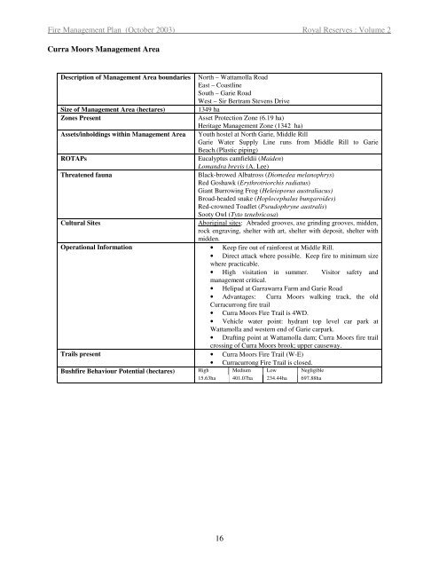
Fire <strong>Management</strong> Plan (October 2003) Royal Reserves : Volume 2<br />
Curra Moors <strong>Management</strong> Area<br />
Description of <strong>Management</strong> Area boundaries North – Wattamolla Road<br />
East – Coastline<br />
South – Garie Road<br />
West – Sir Bertram Stevens Drive<br />
Size of <strong>Management</strong> Area (hectares) 1349 ha<br />
Zones Present Asset Protection Zone (6.19 ha)<br />
Heritage <strong>Management</strong> Zone (1342 ha)<br />
Assets/inholdings within <strong>Management</strong> Area Youth hostel at North Garie, Middle Rill<br />
Garie Water Supply Line runs from Middle Rill to Garie<br />
Beach.(Plastic piping)<br />
ROTAPs Eucalyptus camfieldii (Maiden)<br />
Lomandra brevis (A. Lee)<br />
Threatened fauna Black-browed Albatross (Diomedea melanophrys)<br />
Red Goshawk (Erythrotriorchis radiatus)<br />
Giant Burrowing Frog (Heleioporus australiacus)<br />
Broad-headed snake (Hoplocephalus bungaroides)<br />
Red-crowned Toadlet (Pseudophryne australis)<br />
Sooty Owl (Tyto tenebricosa)<br />
Cultural Sites Aboriginal sites: Abraded grooves, axe grinding grooves, midden,<br />
rock engraving, shelter with art, shelter with deposit, shelter with<br />
midden.<br />
Operational Information • Keep fire out of rainforest at Middle Rill.<br />
• Direct attack where possible. Keep fire to minimum size<br />
where practicable.<br />
• High visitation in summer. Visitor safety and<br />
management critical.<br />
• Helipad at Garrawarra Farm and Garie Road<br />
• Advantages: Curra Moors walking track, the old<br />
Curracurrong fire trail<br />
• Curra Moors Fire Trail is 4WD.<br />
• Vehicle water point: hydrant top level car park at<br />
Wattamolla and western end of Garie carpark.<br />
• Drafting point at Wattamolla dam; Curra Moors fire trail<br />
crossing of Curra Moors brook; upper causeway.<br />
Trails present • Curra Moors Fire Trail (W-E)<br />
• Curracurrong Fire Trail is closed.<br />
Bushfire Behaviour Potential (hectares) High Medium Low Negligible<br />
15.63ha 401.07ha 234.44ha 697.88ha<br />
16


