


You also want an ePaper? Increase the reach of your titles
YUMPU automatically turns print PDFs into web optimized ePapers that Google loves.
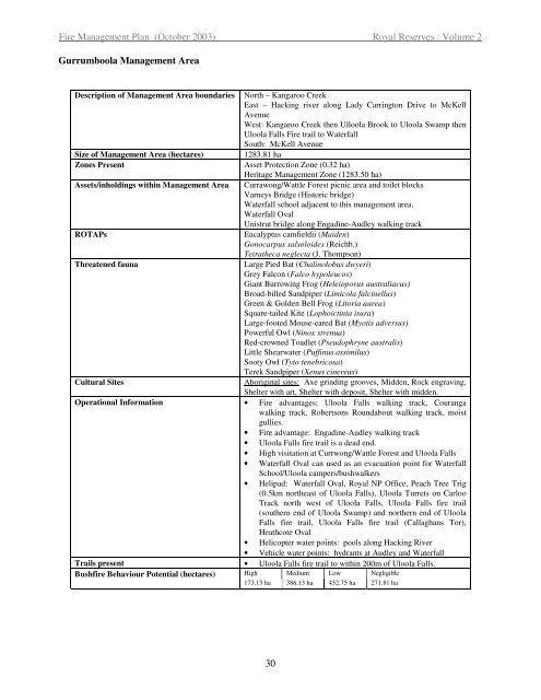
Fire <strong>Management</strong> Plan (October 2003) Royal Reserves : Volume 2<br />
Gurrumboola <strong>Management</strong> Area<br />
Description of <strong>Management</strong> Area boundaries North – Kangaroo Creek<br />
East – Hacking river along Lady Carrington Drive to McKell<br />
Avenue<br />
West: Kangaroo Creek then Ulloola Brook to Uloola Swamp then<br />
Uloola Falls Fire trail to Waterfall<br />
South: McKell Avenue<br />
Size of <strong>Management</strong> Area (hectares) 1283.81 ha<br />
Zones Present Asset Protection Zone (0.32 ha)<br />
Heritage <strong>Management</strong> Zone (1283.50 ha)<br />
Assets/inholdings within <strong>Management</strong> Area Currawong/Wattle Forest picnic area and toilet blocks<br />
Varneys Bridge (Historic bridge)<br />
Waterfall school adjacent to this management area.<br />
Waterfall Oval<br />
Unistrut bridge along Engadine-Audley walking track<br />
ROTAPs Eucalyptus camfieldii (Maiden)<br />
Gonocarpus salsoloides (Reichb.)<br />
Tetratheca neglecta (J. Thompson)<br />
Threatened fauna Large Pied Bat (Chalinolobus dwyeri)<br />
Grey Falcon (Falco hypoleucos)<br />
Giant Burrowing Frog (Heleioporus australiacus)<br />
Broad-billed Sandpiper (Limicola falcinellus)<br />
Green & Golden Bell Frog (Litoria aurea)<br />
Square-tailed Kite (Lophoictinia isura)<br />
Large-footed Mouse-eared Bat (Myotis adversus)<br />
Powerful Owl (Ninox strenua)<br />
Red-crowned Toadlet (Pseudophryne australis)<br />
Little Shearwater (Puffinus assimilus)<br />
Sooty Owl (Tyto tenebricosa)<br />
Terek Sandpiper (Xenus cinereus)<br />
Cultural Sites Aboriginal sites: Axe grinding grooves, Midden, Rock engraving,<br />
Shelter with art, Shelter with deposit, Shelter with midden.<br />
Operational Information • Fire advantages: Uloola Falls walking track, Couranga<br />
walking track, Robertsons Roundabout walking track, moist<br />
gullies.<br />
• Fire advantage: Engadine-Audley walking track<br />
• Uloola Falls fire trail is a dead end.<br />
• High visitation at Currwong/Wattle Forest and Uloola Falls<br />
• Waterfall Oval can used as an evacuation point for Waterfall<br />
School/Uloola campers/bushwalkers<br />
• Helipad: Waterfall Oval, Royal NP Office, Peach Tree Trig<br />
(0.5km northeast of Uloola Falls), Uloola Turrets on Carloo<br />
Track north west of Uloola Falls, Uloola Falls fire trail<br />
(southern end of Uloola Swamp) and northern end of Uloola<br />
Falls fire trail, Uloola Falls fire trail (Callaghans Tor),<br />
Heathcote Oval<br />
• Helicopter water points: pools along Hacking River<br />
• Vehicle water points: hydrants at Audley and Waterfall<br />
Trails present • Uloola Falls fire trail to within 200m of Uloola Falls.<br />
Bushfire Behaviour Potential (hectares) High Medium Low Negligible<br />
173.13 ha 386.13 ha 452.75 ha 271.81 ha<br />
30


