


Create successful ePaper yourself
Turn your PDF publications into a flip-book with our unique Google optimized e-Paper software.
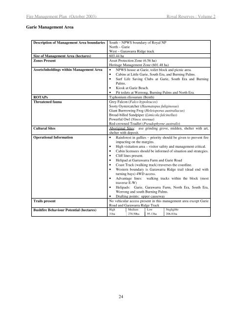
Fire <strong>Management</strong> Plan (October 2003) Royal Reserves : Volume 2<br />
Garie <strong>Management</strong> Area<br />
Description of <strong>Management</strong> Area boundaries South – NPWS boundary of Royal NP<br />
North – Garie<br />
West – Garawarra Ridge track<br />
Size of <strong>Management</strong> Area (hectares) 603.44 ha<br />
Zones Present Asset Protection Zone (6.56 ha)<br />
Heritage <strong>Management</strong> Zone (601.48 ha)<br />
Assets/inholdings within <strong>Management</strong> Area • NPWS house at Garie, toilet block and picnic area.<br />
• Cabins at Little Garie, South Era, and Burning Palms.<br />
• Surf Life Saving Clubs at Garie, South Era and Burning<br />
Palms.<br />
• Kiosk at Garie Beach.<br />
• Pit toilets at Werrong, Burning Palms and North Era.<br />
ROTAPs Typhonium eliosurum (Benth)<br />
Threatened fauna Grey Falcon (Falco hypoleucos)<br />
Sooty Oystercatcher (Haematopus fuliginosus)<br />
Giant Burrrowing Frog (Heleioporus australiacus)<br />
Broad-billed Sandpiper (Limicola falcinellus)<br />
Powerful Owl (Ninox strenua)<br />
Red-crowned Toadlet (Pseudophyrne australis)<br />
Cultural Sites Aboriginal Sites: axe grinding grove, midden, shelter with art,<br />
shelter with deposit.<br />
Operational Information • Rainforest in gullies – priority should be given to prevent fire<br />
impacting on the margins.<br />
• High visitation area – visitor safety and management critical.<br />
• Cabin licensees should be informed of situation and strategies.<br />
• Cliff lines present.<br />
• Helipad at Garrawarra Farm and Garie Road<br />
• Coast Track (walking track) traverses the coastline.<br />
• Western boundary is Garawarra Ridge trail (dead end with<br />
turning bays) 4WD access.<br />
• Advantage lines: walking tracks within the block (most<br />
traverse E-W)<br />
• Helipads: Garie, Garawarra Farm, North Era, South Era,<br />
Werrong and south Burning Palms.<br />
• Drafting points: upper causeway<br />
Trails present No vehicular access present in this management area except Garie<br />
Road and Garawarra Ridge Track<br />
Bushfire Behaviour Potential (hectares) High Medium Low Negligible<br />
31ha 270.50ha 95.13ha 206.81ha<br />
24


