new book: 'the place-names of bute'
new book: 'the place-names of bute'
new book: 'the place-names of bute'

Create successful ePaper yourself
Turn your PDF publications into a flip-book with our unique Google optimized e-Paper software.
processes by which <strong>names</strong> have changed and in<br />
particular how Scots <strong>names</strong> have become not so<br />
much Anglicised as ‘primped’. Not so far from<br />
Linlithgow you can see a sign for Paddockhall<br />
cattery. As you drive past you can see the haugh<br />
and I guess if you were walking you might catch<br />
a glimpse <strong>of</strong> a puddock. But how should we<br />
respond to these historic changes, indicative as<br />
they are, after all, <strong>of</strong> a process by which language<br />
was deliberately changed, where the impact was<br />
not only on the name itself but the vocabulary,<br />
the breadth and depth <strong>of</strong> the lexical items<br />
available to speakers?<br />
In a series <strong>of</strong> articles and essays the Scots<br />
Language Centre has asked academics and<br />
commentators to consider some <strong>of</strong> these issues.<br />
You can read them and, if you like, join in the<br />
debate by visiting the Centre’s web site at<br />
www.scotslanguage.com. You’ll find the <strong>place</strong><br />
name feature on our home page. Folk with an<br />
interest in Scots in the linguistic landscape might<br />
also want to visit our collection <strong>of</strong> images on<br />
flickr. Gathered over five years the collection is a<br />
unique record <strong>of</strong> Scots in public space, some<br />
<strong>of</strong>ficial but mostly ‘community generated’.<br />
I’m hopeful that this fascinating subject<br />
continues to be a matter for discussion by SPNS.<br />
Is action needed, how should we respond to<br />
contemporary and historical <strong>place</strong> name<br />
questions? It would be interesting to have<br />
members’ views.<br />
Michael Hance, Director, Scots Language<br />
Centre<br />
A BERWICKSHIRE PUZZLE<br />
Though English <strong>of</strong> widely separated periods and,<br />
in between those, Scots, have had by far the<br />
greatest influence on the naming <strong>of</strong> <strong>place</strong>s in the<br />
most easterly Border county, there are also<br />
contributions from Gaelic and Northern<br />
Brittonic. Even Norse has a tiny look-in. So it<br />
should not be imagined that everything is simple<br />
in the study <strong>of</strong> Berwickshire <strong>place</strong>-<strong>names</strong>. Just<br />
over the Border from the Liberties <strong>of</strong> Berwick,<br />
on a lane parallel to the main road through<br />
Foulden, is an attractive small group <strong>of</strong><br />
buildings.<br />
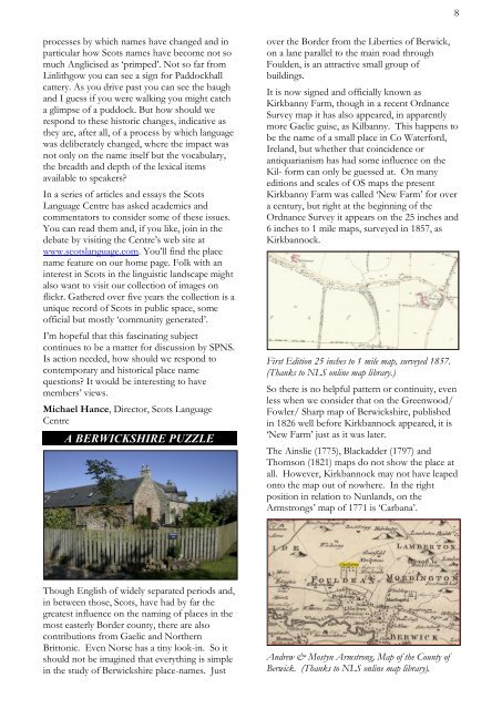
It is now signed and <strong>of</strong>ficially known as<br />
Kirkbanny Farm, though in a recent Ordnance<br />
Survey map it has also appeared, in apparently<br />
more Gaelic guise, as Kilbanny. This happens to<br />
be the name <strong>of</strong> a small <strong>place</strong> in Co Waterford,<br />
Ireland, but whether that coincidence or<br />
antiquarianism has had some influence on the<br />
Kil- form can only be guessed at. On many<br />
editions and scales <strong>of</strong> OS maps the present<br />
Kirkbanny Farm was called ‘New Farm’ for over<br />
a century, but right at the beginning <strong>of</strong> the<br />
Ordnance Survey it appears on the 25 inches and<br />
6 inches to 1 mile maps, surveyed in 1857, as<br />
Kirkbannock.<br />
First Edition 25 inches to 1 mile map, surveyed 1857.<br />
(Thanks to NLS online map library.)<br />
So there is no helpful pattern or continuity, even<br />
less when we consider that on the Greenwood/<br />
Fowler/ Sharp map <strong>of</strong> Berwickshire, published<br />
in 1826 well before Kirkbannock appeared, it is<br />
‘New Farm’ just as it was later.<br />
The Ainslie (1775), Blackadder (1797) and<br />
Thomson (1821) maps do not show the <strong>place</strong> at<br />
all. However, Kirkbannock may not have leaped<br />
onto the map out <strong>of</strong> nowhere. In the right<br />
position in relation to Nunlands, on the<br />
Armstrongs’ map <strong>of</strong> 1771 is ‘Carbana’.<br />
Andrew & Mostyn Armstrong, Map <strong>of</strong> the County <strong>of</strong><br />
Berwick. (Thanks to NLS online map library).<br />
8