Download - iitk.ac.in - Indian Institute of Technology Kanpur
Download - iitk.ac.in - Indian Institute of Technology Kanpur
Download - iitk.ac.in - Indian Institute of Technology Kanpur

You also want an ePaper? Increase the reach of your titles
YUMPU automatically turns print PDFs into web optimized ePapers that Google loves.
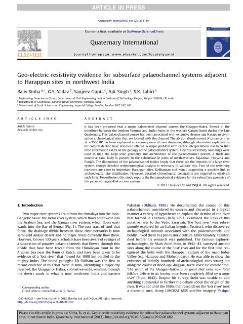
Geo-electric resistivity evidence for subsurf<strong>ac</strong>e palaeochannel systems adj<strong>ac</strong>ent<br />
to Harappan sites <strong>in</strong> northwest India<br />
Rajiv S<strong>in</strong>ha a, *, G.S. Yadav b , Sanjeev Gupta c , Ajit S<strong>in</strong>gh a , S.K. Lahiri a<br />
a<br />
Eng<strong>in</strong>eer<strong>in</strong>g Geosciences Group, Department <strong>of</strong> Civil Eng<strong>in</strong>eer<strong>in</strong>g, <strong>Indian</strong> <strong>Institute</strong> <strong>of</strong> <strong>Technology</strong> <strong>Kanpur</strong>, <strong>Kanpur</strong> 208016, UP, India<br />
b<br />
Department <strong>of</strong> Geophysics, Banaras H<strong>in</strong>du University, Varanasi, India<br />
c<br />
Department <strong>of</strong> Earth Science and Eng<strong>in</strong>eer<strong>in</strong>g, Imperial College London, London SW7 2AZ, UK<br />
article <strong>in</strong>fo<br />
Article history:<br />
Available onl<strong>in</strong>e xxx<br />
1. Introduction<br />
abstr<strong>ac</strong>t<br />
Two major river systems dra<strong>in</strong> from the Himalaya <strong>in</strong>to the Indo-<br />
Gangetic bas<strong>in</strong>: the Indus river system, which flows southwest <strong>in</strong>to<br />
the Arabian Sea, and the Ganges river system, which flows eastwards<br />
<strong>in</strong>to the Bay <strong>of</strong> Bengal (Fig. 1). The vast tr<strong>ac</strong>t <strong>of</strong> land that<br />
forms the dra<strong>in</strong>age divide between these river networks is now<br />
semi-arid and/or desert and no major rivers currently flow there.<br />
However, for over 130 years, scholars have been aware <strong>of</strong> vestiges <strong>of</strong><br />
a succession <strong>of</strong> putative palaeo-channels that flowed through this<br />
divide that have been tr<strong>ac</strong>ed from the Himalayan front to the<br />
Arabian Sea near the Rann <strong>of</strong> Kutch, and have been taken to be<br />
evidence <strong>of</strong> a ‘lost river’ that flowed for 1000 km parallel to the<br />
mighty Indus. The noted geologist RD Oldham was the first to<br />
record evidence <strong>of</strong> this ‘lost river’ <strong>in</strong> 1886, identify<strong>in</strong>g a major dry<br />
riverbed, the Ghaggar or Hakra, kilometres-wide, w<strong>in</strong>d<strong>in</strong>g through<br />
the desert sands <strong>in</strong> what is now northwest India and eastern<br />
* Correspond<strong>in</strong>g author.<br />
E-mail address: rs<strong>in</strong>ha@<strong>iitk</strong>.<strong>ac</strong>.<strong>in</strong> (R. S<strong>in</strong>ha).<br />
1040-6182/$ e see front matter Ó 2012 Elsevier Ltd and INQUA. All rights reserved.<br />
http://dx.doi.org/10.1016/j.qua<strong>in</strong>t.2012.08.002<br />
Quaternary International xxx (2012) 1e10<br />
Contents lists available at SciVerse ScienceDirect<br />
Quaternary International<br />
journal homepage: www.elsevier.com/locate/qua<strong>in</strong>t<br />
It has been proposed that a major palaeo-river channel course, the Ghaggar-Hakra, flowed <strong>in</strong> the<br />
<strong>in</strong>terfluve between the modern Yamuna and Sutlej rivers <strong>in</strong> the western Ganges bas<strong>in</strong> dur<strong>in</strong>g the Late<br />
Quaternary. This palaeochannel course has been associated with extensive Bronze-age Harappan civilisation<br />
archaeological sites that are located with the channel. The abrupt abandonment <strong>of</strong> urban centres<br />
at w3500 BP has been expla<strong>in</strong>ed as a consequence <strong>of</strong> river diversion, although alternative explanations<br />
for cultural decl<strong>in</strong>e have also been <strong>of</strong>fered. A major problem with earlier <strong>in</strong>terpretations has been that<br />
little <strong>in</strong>formation exists on the geology <strong>of</strong> the palaeochannel system. Electrical resistivity sound<strong>in</strong>gs were<br />
used to map the large-scale geometry and architecture <strong>of</strong> the palaeochannel system. A thick and<br />
extensive sand body is present <strong>in</strong> the subsurf<strong>ac</strong>e <strong>in</strong> parts <strong>of</strong> north-western Rajasthan, Haryana and<br />
Punjab. The dimensions <strong>of</strong> the palaeochannel bodies imply that these are the deposits <strong>of</strong> a large river<br />
system, though detailed sedimentological analysis is necessary to validate this. Two <strong>of</strong> the resistivity<br />
transects are close to important Harappan sites, Kalibangan and Kunal, suggest<strong>in</strong>g a possible l<strong>in</strong>k to<br />
archaeological site distribution. However, detailed chronological constra<strong>in</strong>ts are required to establish<br />
such l<strong>in</strong>ks. Nevertheless, this study reports the first geophysical evidence for the subsurf<strong>ac</strong>e geometry <strong>of</strong><br />
the palaeo-Ghaggar-Hakra river system.<br />
Ó 2012 Elsevier Ltd and INQUA. All rights reserved.<br />
Pakistan (Oldham, 1886). He documented the course <strong>of</strong> this<br />
palaeochannel, considered its sources and discussed <strong>in</strong> a logical<br />
manner a variety <strong>of</strong> hypotheses to expla<strong>in</strong> the demise <strong>of</strong> the river<br />
that formed it. Oldham (1874, 1893) exam<strong>in</strong>ed the l<strong>in</strong>ks <strong>of</strong> this<br />
putative river to the Vedic Sarasvati. The ‘lost river’ was subsequently<br />
explored by an Italian l<strong>in</strong>guist, Tessitori, who discovered<br />
archaeological mounds associated with the palaeochannels, and<br />
boldly l<strong>in</strong>ked them to a pre-historic culture. Unfortunately, Tessitori<br />
died before his research was published. The famous explorerarchaeologist,<br />
Sir Mark Aurel Ste<strong>in</strong>, <strong>in</strong> 1942e43, surveyed ancient<br />
sites along the course <strong>of</strong> the ‘lost’ river and for the first time recognised<br />
the l<strong>in</strong>ks with the Harappan culture <strong>of</strong> the ma<strong>in</strong> Indus<br />
Valley (e.g. Harappa and Mohenjodaro). He was able to show the<br />
existence <strong>of</strong> literally hundreds <strong>of</strong> archaeological sites strung out<br />
along the course <strong>of</strong> dried-up Ghaggar-Hakra River. He commented:<br />
‘The width <strong>of</strong> the Ghaggar-Hakra is so great that even now local<br />
folklore believe <strong>in</strong> its hav<strong>in</strong>g once been completely filled by a large<br />
river’ (Ste<strong>in</strong>, 1942). Despite his survey, Ste<strong>in</strong> was unable to add<br />
anyth<strong>in</strong>g substantial to further the debate about the orig<strong>in</strong> <strong>of</strong> the<br />
river. It was not until the 1980s that research on the ‘lost river’ took<br />
a dramatic turn. Us<strong>in</strong>g LANDSAT MSS satellite imagery, Yashpal<br />
Please cite this article <strong>in</strong> press as: S<strong>in</strong>ha, R., et al., Geo-electric resistivity evidence for subsurf<strong>ac</strong>e palaeochannel systems adj<strong>ac</strong>ent to Harappan<br />
sites <strong>in</strong> northwest India, Quaternary International (2012), http://dx.doi.org/10.1016/j.qua<strong>in</strong>t.2012.08.002
2<br />
Fig. 1. Location <strong>of</strong> the study area; the box shows the area <strong>of</strong> <strong>in</strong>vestigation which lies close to several important Harappan sites, Kalibangan, Kunal, Rakhigarhi, and Banawali, <strong>in</strong><br />
northwestern Rajasthan. Three transects chosen for the resistivity surveys, GS, MNK and SRH are also shown.<br />
et al. (1980) identified the course <strong>of</strong> the huge dry riverbed, up to<br />
8 km <strong>in</strong> width and runn<strong>in</strong>g over a distance <strong>of</strong> 400 km, which was<br />
co<strong>in</strong>cident with the previously identified Ghaggar-Hakra channel.<br />
This was the most conv<strong>in</strong>c<strong>in</strong>g evidence that a major river had<br />
perhaps once flowed through this now dry tr<strong>ac</strong>t <strong>of</strong> land. Yashpal<br />
et al. (1980) suggested, on the basis <strong>of</strong> their image analysis, that<br />
it was perhaps possible to connect the tr<strong>ac</strong>e <strong>of</strong> the Ghaggar northwestward<br />
to the Sutlej (now connected to the Beas) and northeastward<br />
to the Yamuna. Ghose et al. (1979) extended the tr<strong>ac</strong>e <strong>of</strong><br />
the putative palaeochannel through LANDSAT image analysis. Thus,<br />
it appeared that major gl<strong>ac</strong>ier-fed Himalayan Rivers might have fed<br />
the large palaeo-river systems, before a series <strong>of</strong> dra<strong>in</strong>age diversion<br />
events caused its desiccation (Valdiya, 2002).<br />
The great significance <strong>of</strong> these postulated palaeo-river systems<br />
is that archaeological evidence suggests that areas adj<strong>ac</strong>ent to the<br />
palaeochannel belt were <strong>in</strong>tensively settled dur<strong>in</strong>g the peak <strong>of</strong> the<br />
Harappan Civilisation (Ste<strong>in</strong>, 1942; <strong>Indian</strong> Archaeology, 1963e64,<br />
1966e67, 1980e81, 1987e88, 1997e98, 1998e99; Wilhelmy,<br />
1969; Dikshit, 1977, 1979; Joshi et al., 1984; Gupta, 1996;<br />
Chakrabarti and Sa<strong>in</strong>i, 2009). The Bronze Age Harappan Civilisation<br />
(4800e3500 BP) was one <strong>of</strong> the world’s first great complex societies<br />
and atta<strong>in</strong>ed its peak after 4400 BP with the development <strong>of</strong><br />
a network <strong>of</strong> sophisticated urban centres spread over an extensive<br />
tr<strong>ac</strong>t <strong>of</strong> NW India and Pakistan (Wright, 2010). Whilst the major<br />
sites <strong>of</strong> Harappa and Mohenjo-Daro are located along the Indus<br />
river system, the largest collection <strong>of</strong> Harappan archaeological sites<br />
is associated with the postulated surf<strong>ac</strong>e tr<strong>ac</strong>e <strong>of</strong> the Ghaggar-<br />
Hakra palaeochannel described above (Joshi et al., 1984; Mughal,<br />
1997). It is generally believed that the river that formed this<br />
palaeochannel belt supported some <strong>of</strong> the major sites <strong>of</strong> this<br />
predom<strong>in</strong>antly river<strong>in</strong>e civilisation. The abrupt abandonment <strong>of</strong><br />
the Harappan civilization here at w3500 BP has <strong>of</strong>ten been l<strong>in</strong>ked<br />
to river diversion/dry<strong>in</strong>g (Ste<strong>in</strong>,1942; S<strong>in</strong>gh,1971; S<strong>in</strong>gh et al.,1974;<br />
Mughal, 1997; Gupta, 2001; Lal, 2002; Valdiya, 2002; Lal et al.,<br />
R. S<strong>in</strong>ha et al. / Quaternary International xxx (2012) 1e10<br />
2003; Staubwasser et al., 2003; Tripathi et al., 2004; Sharma et<br />
al., 2005e06), but no sub-surf<strong>ac</strong>e existence <strong>of</strong> such a river and its<br />
abandonment has been available. These ideas have rema<strong>in</strong>ed<br />
speculative and subject to major discussion (Agrawal, 1964;<br />
Wilhelmy, 1969; Misra, 1984; Courty, 1995; Agrawal and Pande,<br />
1977; Pande, 1977; Kenoyer, 1998; Sahai, 1991; Madella and<br />
Fuller, 2006) due to the l<strong>ac</strong>k <strong>of</strong> detailed subsurf<strong>ac</strong>e data to<br />
confirm the subsurf<strong>ac</strong>e cont<strong>in</strong>uity <strong>of</strong> the large palaeo-channel<br />
system <strong>in</strong>ferred from satellite imagery.<br />
A first step <strong>in</strong> the analysis and <strong>in</strong>terpretation <strong>of</strong> the Ghaggar-<br />
Hakra palaeo-river system as <strong>in</strong>ferred from satellite imagery is to<br />
obta<strong>in</strong> verification that a major palaeo-river sedimentary body does<br />
<strong>in</strong>deed exist <strong>in</strong> the subsurf<strong>ac</strong>e correspond<strong>in</strong>g to the tr<strong>ac</strong>e <strong>of</strong> the<br />
channel <strong>in</strong> satellite imagery. Electrical resistivity is an important<br />
tool for mapp<strong>in</strong>g and reconstruct<strong>in</strong>g the sub-surf<strong>ac</strong>e geometry <strong>of</strong><br />
buried sand bodies, <strong>in</strong> particular, buried fluvial channels that are<br />
potential aquifers. The potential <strong>of</strong> resistivity methods for del<strong>in</strong>eat<strong>in</strong>g<br />
aquifer heterogeneity as a function <strong>of</strong> stratigraphic units has<br />
recently been demonstrated <strong>in</strong> the Mississippi bas<strong>in</strong>, USA (Bowl<strong>in</strong>g<br />
et al., 2005). In this example, stratigraphic units with dist<strong>in</strong>ct<br />
geoelectrical properties were <strong>in</strong>terpreted as deposits <strong>of</strong><br />
meander<strong>in</strong>g rivers, braided rivers, f<strong>in</strong>e-gra<strong>in</strong>ed sand and a clay-rich<br />
<strong>in</strong>terval, and a detailed alluvial architecture was presented. The<br />
application <strong>of</strong> resistivity methods <strong>in</strong> geoarchaeology has also been<br />
attempted. Buried channels <strong>of</strong> the Nile River <strong>in</strong> the Samannud area<br />
<strong>of</strong> the Nile Delta have been mapped us<strong>in</strong>g resistivity surveys (El<br />
Gamili et al., 1994; El Gamili et al., 2001) to test the relationship<br />
<strong>of</strong> some <strong>of</strong> the important archaeological sites related to ancient<br />
Egyptian history to Nile branches. Although the historical documents<br />
suggested that the old settlements <strong>in</strong> this area had <strong>ac</strong>cess to<br />
some <strong>of</strong> the branches <strong>of</strong> the Nile River, there were serious<br />
disagreements on this hypothesis. The resistivity surveys <strong>ac</strong>ross the<br />
documented branches carried out by El Gamili and Ibrahim (2001)<br />
identified three geoelectric layers consist<strong>in</strong>g <strong>of</strong> clays and silts,<br />
Please cite this article <strong>in</strong> press as: S<strong>in</strong>ha, R., et al., Geo-electric resistivity evidence for subsurf<strong>ac</strong>e palaeochannel systems adj<strong>ac</strong>ent to Harappan<br />
sites <strong>in</strong> northwest India, Quaternary International (2012), http://dx.doi.org/10.1016/j.qua<strong>in</strong>t.2012.08.002
saturated clay and a buried sand layer based on resistivity variations<br />
and representative borehole data. The buried sand layer was<br />
<strong>in</strong>terpreted as the ‘defunct’ branches <strong>of</strong> the Nile river, <strong>in</strong> l<strong>in</strong>e with<br />
the historical and archaeological documentation that these are<br />
Bucolic and Sebennytic branches <strong>of</strong> the Neonile which were<br />
established at the end <strong>of</strong> Pleistocene (El Gamili and Ibrahim, 2001).<br />
The electrical resistivity method was applied to reconstruct the<br />
subsurf<strong>ac</strong>e stratigraphic geometry along three transects <strong>in</strong> northwest<br />
India. The southernmost transect (GS) is close to the major<br />
Harappan archaeological site <strong>of</strong> Kalibangan (Fig. 1). The second<br />
transect (MNK) is w20 km north <strong>of</strong> Kunal archaeological site and<br />
the northernmost transect (SRH) is near Sirh<strong>in</strong>d <strong>in</strong> Punjab. The<br />
resistivity survey for the GS and MNK transects was conducted with<br />
the overall aim <strong>of</strong> determ<strong>in</strong><strong>in</strong>g if the surf<strong>ac</strong>e tr<strong>ac</strong>e <strong>of</strong> the postulated<br />
Ghaggar-Hakra fluvial system as discerned from satellite imagery<br />
corresponds to a subsurf<strong>ac</strong>e palae<strong>of</strong>luvial sedimentary body. The<br />
SRH transect was designed to test the proposition by Yashpal et al.<br />
(1980) that a palaeochannel branch, possibly the palaeo-Sutlej,<br />
existed <strong>in</strong> northern Punjab and connected downstream to the<br />
Ghaggar-Hakra palaeochannel. The specific objectives were to: (a)<br />
map the subsurf<strong>ac</strong>e sand body geometry, and (b) establish the edge<br />
<strong>of</strong> the palaeovalley. This paper presents the resistivity results and<br />
buried valley geometry <strong>in</strong>terpretation, and discusses their geoarchaeological<br />
significance.<br />
2. Study area description e the geoarchaeological context<br />
Two transects, GS and MNK, <strong>in</strong> the study area lie <strong>in</strong> the western<br />
Haryana pla<strong>in</strong>s close to the important Harappan archaeological<br />
sites <strong>of</strong> Kalibangan and Kunal respectively (Lal et al., 2003). This<br />
area lies at the north-eastern edge <strong>of</strong> the Thar Desert with an<br />
annual precipitation <strong>of</strong> 300e450 mm/y fall<strong>in</strong>g dur<strong>in</strong>g the monsoon<br />
months only, and therefore, a semi-arid climatic regime prevails <strong>in</strong><br />
this region. At present, no major rivers flow through this area<br />
except for a m<strong>in</strong>or dra<strong>in</strong>age l<strong>in</strong>e <strong>of</strong> the seasonal Ghaggar River that<br />
orig<strong>in</strong>ates <strong>in</strong> the Siwalik foothills <strong>of</strong> the Himalaya. However, the<br />
most enigmatic aspect <strong>of</strong> the Ghaggar River has been a very large<br />
palaeovalley (>3 km wide) observed on the satellite image that is<br />
not commensurate with the dimension <strong>of</strong> the modern Ghaggar<br />
river (less than 250 m wide). The modern Ghaggar River presently<br />
flows towards the southern end <strong>of</strong> the wide valley. Apart from this,<br />
several palaeochannel tr<strong>ac</strong>es are visible <strong>in</strong> the desert area further to<br />
the west, which suggests that a denser dra<strong>in</strong>age network previously<br />
existed <strong>in</strong> this region.<br />
The existence <strong>of</strong> a large river <strong>in</strong> ancient times with<strong>in</strong> this wide<br />
valley has rema<strong>in</strong>ed speculative due to the l<strong>ac</strong>k <strong>of</strong> any reliable subsurf<strong>ac</strong>e<br />
data to confirm the sub-surf<strong>ac</strong>e cont<strong>in</strong>uity <strong>of</strong> the large<br />
valley observed on the surf<strong>ac</strong>e. The only exception is a recent study<br />
by Sa<strong>in</strong>i et al. (2009) who utilized shallow well sections (8 m) and<br />
groundwater well logs (>40 m deep) from an area south <strong>of</strong> the<br />
Ghaggar River and identified fluvial sand bodies <strong>in</strong>ter-layered with<br />
aeolian sand, and brown silt and clay <strong>of</strong> floodpla<strong>in</strong> deposits. Based<br />
on the spatial correlation <strong>of</strong> the litho-sections along two transects,<br />
the authors marked two major buried channels, south <strong>of</strong> modern<br />
Ghaggar river, for a length <strong>of</strong> w250 km hav<strong>in</strong>g fluvial sand bodies<br />
up to 30 m thick occurr<strong>in</strong>g 4e10 m below ground surf<strong>ac</strong>e, and<br />
associated floodpla<strong>in</strong> deposits up to 50 m thick. Sa<strong>in</strong>i et al. (2009)<br />
and Sa<strong>in</strong>i and Mujtaba (2010) also dated the top <strong>of</strong> the sand body<br />
to be 26 2to21 1 ka BP. The authors suggested that these buried<br />
channels were <strong>ac</strong>tive around MIS 3 and went through a disorganization<br />
phase dur<strong>in</strong>g the LGM. The aeolian sand overly<strong>in</strong>g the buried<br />
channel was dated between w20 and w15 ka BP. They also mapped<br />
a few patches <strong>of</strong> a younger paleochannel that dated around<br />
5.9 0.3 and 2.9 0.2 ka BP and considered them to be a part <strong>of</strong> the<br />
‘lost’ Saraswati (Yashpal et al., 1980; Sahai, 1991).<br />
R. S<strong>in</strong>ha et al. / Quaternary International xxx (2012) 1e10 3<br />
This study has aimed at confirm<strong>in</strong>g the presence <strong>of</strong> the buried<br />
channel through resistivity surveys and drill cores and to establish<br />
its upstream connectivity. Two transects for resistivity sound<strong>in</strong>gs<br />
mapped the sub-surf<strong>ac</strong>e lithology <strong>of</strong> the region close to Kalibangan<br />
(29 28 0 13.66 00 N, 76 07 0 49.06 00 E) and Kunal (29 37 0 41.18 00 N,<br />
75 39 0 44.16 00 E) (Fig. 1) <strong>ac</strong>ross the large valley partially occupied by<br />
the Ghaggar river channel at present. The third transect, SRH, was<br />
located <strong>ac</strong>ross the tr<strong>ac</strong>e <strong>of</strong> a palaeochannel near Sirh<strong>in</strong>d<br />
(30 37 0 41.98 00 N, 76 23 0 10.98 00 E) <strong>in</strong> Punjab close to the Himalayan<br />
front; this was orig<strong>in</strong>ally identified by Yashpal et al. (1980) as<br />
a possible former course <strong>of</strong> the Sutlej river. Although this area lies <strong>in</strong><br />
the semi-humid, northern Indo-Gangetic pla<strong>in</strong>s with an average<br />
annual ra<strong>in</strong>fall <strong>of</strong> 690 mm/year, there is no major surf<strong>ac</strong>e dra<strong>in</strong>age<br />
<strong>in</strong> this region. The modern Sutluj flows w150 km west and the<br />
Yamuna flows w150 km east <strong>of</strong> this transect. It has been suggested<br />
that the Sutluj flowed through this region before mov<strong>in</strong>g west<br />
(Yashpal et al., 1980) but there is no data to test if a palaeochannel is<br />
present <strong>in</strong> the subsurf<strong>ac</strong>e <strong>in</strong> this region, which may have connected<br />
downstream with the Ghaggar palaeochannel.<br />
3. Data <strong>ac</strong>quisition and process<strong>in</strong>g<br />
3.1. Resistivity surveys and data <strong>in</strong>terpretation<br />
A Terrameter SAS 1000 (manuf<strong>ac</strong>turer; ABEM, Sweden) as well<br />
as an Aquameter CRM 500 (manuf<strong>ac</strong>turer; ANVIC systems) were<br />
used to conduct electrical resistivity survey for the transects, as<br />
described above. Vertical electrical sound<strong>in</strong>gs were taken at 14<br />
locations along the GS transect and at 10 locations e<strong>ac</strong>h along the<br />
MNK and SRH transects (Figs. 2, 4 and 6 ) to provide constra<strong>in</strong>ts<br />
about the spatial as well as vertical extent <strong>of</strong> the buried fluvial<br />
complex. The resistivity <strong>of</strong> the buried sand body is dist<strong>in</strong>guishable<br />
on two <strong>ac</strong>counts: (a) the overly<strong>in</strong>g mud generally has a lower<br />
resistivity unless <strong>ac</strong>companied by concretions, and (b) the underly<strong>in</strong>g<br />
sand/mud has a very low resistivity due to high sal<strong>in</strong>ity.<br />
In this study, high-resolution electrical resistivity sound<strong>in</strong>g data<br />
were obta<strong>in</strong>ed us<strong>in</strong>g a Schlumberger array apply<strong>in</strong>g small <strong>in</strong>crements<br />
<strong>in</strong> the current electrode separations. Small <strong>in</strong>crements <strong>of</strong><br />
about 1.25 times were made <strong>in</strong> the successive current electrode<br />
separation (AB/2) to <strong>in</strong>crease number <strong>of</strong> observations <strong>in</strong> a log cycle<br />
<strong>in</strong> order to map th<strong>in</strong> layers. Maximum separations (AB) rang<strong>in</strong>g<br />
from 600 m to 1000 m were used depend<strong>in</strong>g upon the availability<br />
<strong>of</strong> sp<strong>ac</strong>e along the pr<strong>of</strong>ile l<strong>in</strong>e.<br />
The resistivity sound<strong>in</strong>g data were <strong>in</strong>terpreted first <strong>in</strong> terms <strong>of</strong><br />
physical parameters, namely resistivity and thickness <strong>of</strong> the<br />
formations, and then these parameters were correlated with the<br />
available lithological data to <strong>in</strong>terpret the subsurf<strong>ac</strong>e stratigraphy.<br />
Various techniques are available for <strong>in</strong>terpret<strong>in</strong>g the resistivity<br />
sound<strong>in</strong>g data. Kim et al. (2001) used statistical methods to <strong>in</strong>terpret<br />
electrical resistivity data. Yadav et al. (2010) have discussed, <strong>in</strong><br />
detail, the methodology and techniques used for the <strong>in</strong>terpretation<br />
<strong>of</strong> geoelectrical sound<strong>in</strong>g data for the alluvial pla<strong>in</strong>s <strong>in</strong> the Ganga<br />
bas<strong>in</strong>. Most <strong>of</strong> the techniques for the <strong>in</strong>terpretation <strong>of</strong> resistivity<br />
data are based on the assumption that the geoelectrical layers<br />
extend horizontally to <strong>in</strong>f<strong>in</strong>ity and are isotropic, homogeneous<br />
entities with dist<strong>in</strong>ct electrical resistivity contrast and thicknesses.<br />
Though all these conditions are seldom satisfied, these techniques<br />
are useful <strong>in</strong> <strong>in</strong>ferr<strong>in</strong>g broad scale subsurf<strong>ac</strong>e hydrogeological<br />
conditions.<br />
The <strong>in</strong>terpretation <strong>of</strong> resistivity sound<strong>in</strong>g data was carried out <strong>in</strong><br />
two stages. The first stage <strong>in</strong>volved the <strong>in</strong>terpretation purely on<br />
theoretical considerations <strong>in</strong> order to develop a basic geoelectrical<br />
model. In the second stage, the <strong>in</strong>terpreted results were correlated<br />
with the available lithological <strong>in</strong>formation and validated <strong>ac</strong>cord<strong>in</strong>gly<br />
to determ<strong>in</strong>e resistivity ranges for different lithological units.<br />
Please cite this article <strong>in</strong> press as: S<strong>in</strong>ha, R., et al., Geo-electric resistivity evidence for subsurf<strong>ac</strong>e palaeochannel systems adj<strong>ac</strong>ent to Harappan<br />
sites <strong>in</strong> northwest India, Quaternary International (2012), http://dx.doi.org/10.1016/j.qua<strong>in</strong>t.2012.08.002
4<br />
Stratigraphic boundaries are not always associated with lithological<br />
variation and a good correlation may sometimes be difficult due to<br />
a variety <strong>of</strong> reasons viz. th<strong>in</strong> layers embedded <strong>in</strong> a thick layer <strong>of</strong><br />
different material, variations <strong>in</strong> groundwater sal<strong>in</strong>ity. On the other<br />
hand, a s<strong>in</strong>gle lithological unit may <strong>in</strong>clude a number <strong>of</strong> geoelectrical<br />
<strong>in</strong>terf<strong>ac</strong>es without any significant variation <strong>in</strong> its<br />
char<strong>ac</strong>ter.<br />
The quantitative <strong>in</strong>terpretation <strong>in</strong>volved determ<strong>in</strong>ation <strong>of</strong> the<br />
thickness <strong>of</strong> the different formations hav<strong>in</strong>g different resistivities<br />
from the field sound<strong>in</strong>g curves. Field curves were compared with<br />
the theoretically generated or available standard master curves for<br />
known layer parameters <strong>of</strong> two, three and four layers (Orellana and<br />
Mooney, 1966; Rijkswaterstaat, 1969). Initial layer parameters were<br />
obta<strong>in</strong>ed us<strong>in</strong>g partial curve match<strong>in</strong>g technique with the help <strong>of</strong><br />
master curves and auxiliary po<strong>in</strong>t charts (Ebert, 1943). F<strong>in</strong>al layer<br />
parameters were obta<strong>in</strong>ed through <strong>in</strong>verse modell<strong>in</strong>g for a known<br />
RMS error between the field curve and theoretically computed<br />
apparent resistivity curve.<br />
3.2. Calibration <strong>of</strong> resistivity data with drill core<br />
Fig. 2 shows the basis <strong>of</strong> <strong>in</strong>terpretation <strong>of</strong> lithological layers<br />
based on the field resistivity curve. Field resistivity curve for one <strong>of</strong><br />
the sites (GS-11) along the GS transect (Fig. 2a) is shown <strong>in</strong> Fig. 2b.<br />
The <strong>in</strong>terpreted 6-layer resistivity model (Fig. 2c) with dist<strong>in</strong>ct<br />
variations <strong>in</strong> resistivity values. This model was calibrated aga<strong>in</strong>st<br />
R. S<strong>in</strong>ha et al. / Quaternary International xxx (2012) 1e10<br />
Fig. 2. (a) A Landsat image show<strong>in</strong>g the transect for the resistivity survey <strong>ac</strong>ross the modern Ghaggar channel. GS1..GS14 are the locations <strong>of</strong> resistivity sound<strong>in</strong>gs. (b) Apparent<br />
resistivity curve for sound<strong>in</strong>g done at GS-11. (c) Interpreted resistivity model for this site shows 5 layers with a very high resistivity layer at the base. (d) Calibration <strong>of</strong> the resistivity<br />
data with the litholog <strong>of</strong> a drill core at this site. A thick sand body with fresh groundwater is clearly mapped <strong>in</strong> the resistivity data. The high resistivity layer at the base matches with<br />
the calcrete (kankar) layer which generally separates the fresh water aquifer from the sal<strong>in</strong>e water below.<br />
a sediment core raised from this site which is w40 m deep and<br />
conta<strong>in</strong>s most <strong>of</strong> the sedimentary lithologies typical <strong>of</strong> an amalgamated<br />
fluvial channel complex (Fig. 2d). Similar calibration <strong>of</strong><br />
resistivity data was developed for MNK and SRH transects us<strong>in</strong>g<br />
drill core logs (see Figs. 4 and 6).<br />
Based on the resistivity sound<strong>in</strong>g, 4e6 layer models were<br />
developed for e<strong>ac</strong>h site. Us<strong>in</strong>g the available lithologs from all<br />
transects, all resistivity models from all sites were compared and<br />
the range <strong>of</strong> resistivity values for different lithological units were<br />
determ<strong>in</strong>ed (Table 1). Based on this data, different layers <strong>ac</strong>ross<br />
different sites were correlated, and f<strong>in</strong>ally, simplified alluvial<br />
stratigraphic models <strong>ac</strong>ross the different transects were generated<br />
(Figs. 3, 5 and 7).<br />
4. Results and <strong>in</strong>terpretation<br />
The shallow subsurf<strong>ac</strong>e stratigraphy for e<strong>ac</strong>h <strong>of</strong> the three transects<br />
GS, MNK, and SRH is shown <strong>in</strong> Figs. 3, 5 and 7 respectively. The<br />
surf<strong>ac</strong>e pr<strong>of</strong>ile for e<strong>ac</strong>h transect was constructed from a SRTM<br />
digital terra<strong>in</strong> model (90 m resolution) <strong>in</strong> the ESRI ArcGIS 10.0<br />
environment. The surf<strong>ac</strong>e pr<strong>of</strong>iles were smoothed for 5 po<strong>in</strong>t<br />
runn<strong>in</strong>g average and <strong>in</strong>terpreted resistivity values were plotted<br />
below the location <strong>of</strong> the VES station, for e<strong>ac</strong>h transect, on their<br />
respective pr<strong>of</strong>iles. Different stratigraphic layers were marked <strong>in</strong><br />
e<strong>ac</strong>h transect follow<strong>in</strong>g the different range <strong>of</strong> resistivity values,<br />
identified after data calibration (Table 1).<br />
Please cite this article <strong>in</strong> press as: S<strong>in</strong>ha, R., et al., Geo-electric resistivity evidence for subsurf<strong>ac</strong>e palaeochannel systems adj<strong>ac</strong>ent to Harappan<br />
sites <strong>in</strong> northwest India, Quaternary International (2012), http://dx.doi.org/10.1016/j.qua<strong>in</strong>t.2012.08.002
4.1. GS-transect<br />
The roughly NWeSE trend<strong>in</strong>g GS transect runn<strong>in</strong>g close to the<br />
Kalibangan Harappan site (Fig. 2) has a slope <strong>of</strong> w0.1 m/km towards<br />
northwest and no clear surf<strong>ac</strong>e topography is discernable. Five<br />
different lithological layers (L1eL5) were dist<strong>in</strong>guished <strong>in</strong> the<br />
resistivity based stratigraphic reconstruction along a transect<br />
runn<strong>in</strong>g at 90 to the postulated surf<strong>ac</strong>e tr<strong>ac</strong>e <strong>of</strong> the palaeo-<br />
Ghaggar channel (Fig. 3). The uppermost layer (L1) <strong>in</strong> all sound<strong>in</strong>gs<br />
has variable resistivity values with thickness vary<strong>in</strong>g between<br />
1 and 5 m. This is <strong>in</strong>terpreted as a topsoil layer, which is thickest<br />
around GS-10. This is close to the position <strong>of</strong> the modern Ghaggar<br />
river channel and may represent near-channel deposition by the<br />
modern river. Underly<strong>in</strong>g L1, L2 shows resistivity values between<br />
12 and 39 U-m and is fairly cont<strong>in</strong>uous <strong>ac</strong>ross the pr<strong>of</strong>ile. This is<br />
<strong>in</strong>terpreted as a silty-sand layer with carbonate concretions (kankars<br />
or calcrete) based on correlations with core GS11 and local<br />
<strong>in</strong>formation. This layer is much thicker (>15 m at GS-13) towards<br />
the northern end <strong>of</strong> the pr<strong>of</strong>ile with channel-form geometry. A<br />
similar geometry <strong>of</strong> this layer is also observed towards the southern<br />
end with a thickness <strong>of</strong> >6 m between GS-9 and GS-10 and this<br />
p<strong>in</strong>ches out to less than 2 m towards the southern end <strong>of</strong> the<br />
pr<strong>of</strong>ile. This layer is a channel fill deposit. This layer shows significant<br />
lateral variability <strong>in</strong> terms <strong>of</strong> resistivity values. For example,<br />
a pocket <strong>of</strong> slightly higher resistivity values (w90 U-m) capp<strong>in</strong>g this<br />
layer at GS-8 is <strong>in</strong>terpreted as a m<strong>in</strong>or sand lens embedded with<strong>in</strong><br />
the muddy matrix. A few patches <strong>of</strong> low resistivity values (3e11 Um)<br />
are also noted with<strong>in</strong> this layer, which are <strong>in</strong>terpreted as lenses<br />
<strong>of</strong> clayey sediments.<br />
Between w5 and w20 m depth, there is a layer L3 <strong>of</strong> high<br />
resistivity (213e835 U-m) which has a channel-form cross<br />
sectional geometry. This layer is <strong>in</strong>terpreted as dry sand with<br />
kankars (carbonate nodules). This sand body is clearly segmented<br />
<strong>in</strong>to two parts by a muddy layer around GS-13; it is thickest towards<br />
R. S<strong>in</strong>ha et al. / Quaternary International xxx (2012) 1e10 5<br />
Fig. 3. (a) Resistivity sound<strong>in</strong>g data for 10 sites <strong>ac</strong>ross the palaeo-Ghaggar valley. The numbers <strong>in</strong>dicate the values <strong>of</strong> the apparent resistivity for different layers. The dashed l<strong>in</strong>e<br />
<strong>in</strong>dicates the <strong>in</strong>terpreted sand body with fresh water. (b) Resistivity-based stratigraphic model for transect <strong>ac</strong>ross the Palaeo-Ghaggar valley along the Gs transect. The buried<br />
channel body (sand with fresh groundwater) is dist<strong>in</strong>ctly mapped <strong>in</strong> the resistivity data. The lower bound <strong>of</strong> this sand body is marked by a sharp change <strong>in</strong> resistivity values, either<br />
too low (due to high sal<strong>in</strong>ity <strong>of</strong> groundwater) or too high (presence <strong>of</strong> calcrete layer). The sand body is overla<strong>in</strong> by dry sand layer with pockets <strong>of</strong> mud.<br />
north (>15 m around GS-5) and p<strong>in</strong>ches out towards south with<br />
a thickness <strong>of</strong>
6<br />
4.2. MNK-transect<br />
The MNK transect is w20 km long and runs close to the Kunal<br />
Harappan site and <strong>ac</strong>ross the buried fluvial system, centred near<br />
Moonak (also known as Akalgarh) village (29 49 0 16.36 00 N,<br />
75 53 0 33.37 00 E). Presently, the modern Ghaggar River flows as<br />
a narrow and conf<strong>in</strong>ed channel <strong>in</strong> this region. The roughly NWeSE<br />
oriented transect has a slope <strong>of</strong> about 0.34 m/km towards northwest.<br />
Ten resistivity sound<strong>in</strong>g po<strong>in</strong>ts (MNK-1 to MNK-10) almost<br />
evenly distributed along the length <strong>of</strong> transect (Fig. 4) and two drill<br />
cores at MNK-5 and MNK-6 were used to reconstruct the subsurf<strong>ac</strong>e<br />
alluvial architecture along this transect (Fig. 5).<br />
The topsoil layer shows variable thickness between w1and2.8m,<br />
and consists <strong>of</strong> red silty clays, sometimes pedogenised with occasional<br />
presence <strong>of</strong> very small calcrete nodules. The topsoil layer,<br />
marked as L1, has resistivity values <strong>in</strong> the range <strong>of</strong> 18e90 U-m at<br />
different sound<strong>in</strong>g po<strong>in</strong>ts. This layer is unusually thick (w9.5 m) at<br />
VES location MNK-9 that is located close to the present course <strong>of</strong><br />
modern Ghaggar River. The underly<strong>in</strong>g L2 layer, w3e10 m thick, is<br />
<strong>in</strong>terpreted as a silty sand body with resistivity values between 12<br />
and 50 U-m. A similar lithology is encountered aga<strong>in</strong> at deeper<br />
depths and at the marg<strong>in</strong> <strong>of</strong> transect. The L3 layer, hav<strong>in</strong>g a variable<br />
thickness <strong>of</strong> w1e10 m with resistivity values between 461 and<br />
752 U-m, is fairly cont<strong>in</strong>uous throughout the transect. The underly<strong>in</strong>g<br />
L4 layer is present ma<strong>in</strong>ly <strong>in</strong> the central part <strong>of</strong> transect, with<br />
a variable thickness <strong>of</strong> 5e20 m and resistivity values vary<strong>in</strong>g between<br />
R. S<strong>in</strong>ha et al. / Quaternary International xxx (2012) 1e10<br />
Fig. 4. (a) A Landsat image show<strong>in</strong>g the MNK transect <strong>ac</strong>ross the palaeo-Ghaggar valley; MNK1..MNK10 are the locations <strong>of</strong> resistivity sound<strong>in</strong>gs. The modern Ghaggar channel<br />
flows with<strong>in</strong> this valley and sw<strong>in</strong>gs from the northern to southern edge <strong>of</strong> the valley <strong>in</strong> this w<strong>in</strong>dow. (b) Apparent resistivity curve for sound<strong>in</strong>g done at MNK-6. (c) Interpreted<br />
resistivity model for this site shows 6 layers with a very low resistivity layer at the base. (d) Calibration <strong>of</strong> the resistivity data with the litholog <strong>of</strong> a drill core at this site. A thick sand<br />
body with fresh groundwater is clearly mapped <strong>in</strong> the resistivity data. Very low resistivity layer at the base is <strong>in</strong>terpreted as sand layer with sal<strong>in</strong>e water.<br />
108 and 473 U-m. Both L3 and L4 layers represent sand bodies with<br />
the only difference that L3 is dry sand while L4 is saturated with<br />
fresh water. A dramatic drop <strong>in</strong> resistivity values (
R. S<strong>in</strong>ha et al. / Quaternary International xxx (2012) 1e10 7<br />
Fig. 5. (a) Resistivity sound<strong>in</strong>g data for 9 sites along the MNK transect. The numbers <strong>in</strong>dicate the values <strong>of</strong> the apparent resistivity for different layers. The dashed l<strong>in</strong>e <strong>in</strong>dicates the<br />
<strong>in</strong>terpreted sand body with fresh water. (b) Resistivity-based stratigraphic model for the MNK transect. The buried channel body (sand with fresh groundwater) is quite narrow<br />
along this transect and the lower bound <strong>of</strong> this sand body is marked by a sharp decrease <strong>in</strong> resistivity values due to high sal<strong>in</strong>ity <strong>of</strong> groundwater. The sand body is bounded laterally<br />
on both sides by silty sand and overla<strong>in</strong> by dry sand layer with kankars.<br />
Fig. 6. (a) A Landsat image show<strong>in</strong>g the SRH transect <strong>ac</strong>ross the palaeo-Sutluj valley; SRH1..SRH11 are the locations <strong>of</strong> resistivity sound<strong>in</strong>gs. (b) Apparent resistivity curve for<br />
sound<strong>in</strong>g done at SRH-5. (c) Interpreted resistivity model for this site shows 6 layers with a low resistivity layer at the base. (d) Calibration <strong>of</strong> the resistivity data with the litholog <strong>of</strong><br />
a drill core at this site. A thick sand body with fresh groundwater is clearly mapped <strong>in</strong> the resistivity data. Low resistivity layer at the base is <strong>in</strong>terpreted as muddy layer (not<br />
penetrated <strong>in</strong> the drill core).<br />
Please cite this article <strong>in</strong> press as: S<strong>in</strong>ha, R., et al., Geo-electric resistivity evidence for subsurf<strong>ac</strong>e palaeochannel systems adj<strong>ac</strong>ent to Harappan<br />
sites <strong>in</strong> northwest India, Quaternary International (2012), http://dx.doi.org/10.1016/j.qua<strong>in</strong>t.2012.08.002
8<br />
Table 1<br />
Range <strong>of</strong> resistivities for different lithological units.<br />
Lithological units Resistivity (U-m)<br />
Top soil (L1) 4e90<br />
Silty sand (L2) 12e87<br />
Dry sand (L3) 259e835<br />
Dry sand with carbonate concretions (kankars) (L3a) 1729e7132<br />
Sand with fresh water (L4) 41e177<br />
Sand with sal<strong>in</strong>e water (L5) 10,000<br />
M<strong>in</strong>or mud fills (L7) 1e9<br />
SRH-5 and SRH-6 that shows low resistivity values (w1.3e1.9 U-m).<br />
The L2 layer repeats below the L4 layer for a large part <strong>of</strong> transect. A<br />
dist<strong>in</strong>ctive feature <strong>of</strong> this transect is the presence <strong>of</strong> a very high<br />
resistivity layer (L6) at the base which marks a lithological<br />
discont<strong>in</strong>uity between L5 and L6. None <strong>of</strong> the drill cores<br />
penetrated this layer, and it is tentatively <strong>in</strong>terpreted as sand<br />
with gravels. This <strong>in</strong>terpretation is based on the proximity <strong>of</strong> this<br />
transect to the mounta<strong>in</strong> front and the limited field observations<br />
that gravels occur at shallow levels (12 km wide<br />
and 30 m thick) that is an order <strong>of</strong> magnitude larger than the<br />
modern Ghaggar river channel (
the presence <strong>of</strong> aeolian mounds on either side <strong>of</strong> the palaeochannel<br />
complex around Kalibangan.<br />
The SRH transect was primarily designed to tr<strong>ac</strong>k the subsurf<strong>ac</strong>e<br />
existence <strong>of</strong> a palaeochannel complex <strong>in</strong> northern Punjab<br />
orig<strong>in</strong>ally identified by Yashpal et al. (1980) as a possible tributary<br />
to the Ghaggar-Hakra palaeochannel. Resistivity data confirms<br />
a large sand body, 40e50 m thick, although there is no surf<strong>ac</strong>e<br />
expression <strong>of</strong> this large valley. This sand body is covered with<br />
a hard and comp<strong>ac</strong>t layer reflected by very high resistivity values.<br />
The sand body has a dist<strong>in</strong>ct channel-form geometry that is thickest<br />
<strong>in</strong> the centre <strong>of</strong> the transect and tapers on both sides. Unlike the GS<br />
and MNK transects, no layer with sal<strong>in</strong>e water was encountered<br />
along this transect <strong>in</strong> the upper 70 m <strong>of</strong> the strata represented by<br />
the resistivity data. A layer with very high resistivity value at the<br />
base is <strong>in</strong>terpreted as a gravelly bed. This is attributed to the<br />
proximal position <strong>of</strong> this transect based on limited field<br />
observations.<br />
Stratigraphic data from the GS and MNK transects compare<br />
well with that <strong>of</strong> the AB transect published by Sa<strong>in</strong>i et al. (2009)<br />
based on groundwater borehole data. The sand body thickness <strong>of</strong><br />
the buried channel complex <strong>in</strong> all <strong>of</strong> these transects ranges<br />
between 25 and 30 m and is underla<strong>in</strong> by aeolian sand and<br />
covered with floodpla<strong>in</strong> muds and aeolian silts. However, the<br />
buried channel separated by wide <strong>in</strong>terfluves mapped along the<br />
AB transect is w25 km south <strong>of</strong> the valley marg<strong>in</strong> <strong>of</strong> the ma<strong>in</strong><br />
channel complex. In the absence <strong>of</strong> <strong>in</strong>tensive chronological data,<br />
it is difficult to comment if these buried channels co-existed or<br />
are time-separated. However, there are several examples <strong>in</strong> the<br />
Gangetic bas<strong>in</strong> from where large-scale avulsions <strong>of</strong> large rivers<br />
and valley migration have been reported over time scales <strong>of</strong><br />
10 3 e10 4 years (Gibl<strong>in</strong>g et al., 2005; Tandon et al., 2006; S<strong>in</strong>ha<br />
et al., 2007; S<strong>in</strong>ha, 2009). It has been suggested that the valley<br />
prom<strong>in</strong>ence may change with time and sp<strong>ac</strong>e as a function <strong>of</strong><br />
climate and hydrological regime (Tandon et al., 2006) or<br />
R. S<strong>in</strong>ha et al. / Quaternary International xxx (2012) 1e10 9<br />
Fig. 8. Sub-surf<strong>ac</strong>e stratigraphy <strong>of</strong> the Ghaggar and paleo-Sutluj valley based on the data presented <strong>in</strong> this paper and published by Sa<strong>in</strong>i et al. (2009).<br />
tectonics (Gupta, 1997). It is likely that the discovered buried<br />
channels so far are a part <strong>of</strong> a much large dra<strong>in</strong>age network<br />
which has varied <strong>in</strong> time and sp<strong>ac</strong>e. A more detailed and <strong>in</strong>tensive<br />
<strong>in</strong>vestigation <strong>of</strong> sub-surf<strong>ac</strong>e stratigraphy is required to<br />
confirm these ideas.<br />
These resistivity results represent the first stratigraphic<br />
evidence that a palaeochannel exists <strong>in</strong> the sub-surf<strong>ac</strong>e alluvium<br />
both <strong>in</strong> the Ghaggar valley. The f<strong>ac</strong>t that the major urban sites <strong>of</strong><br />
Kalibangan and Kunal lie adj<strong>ac</strong>ent to the newly discovered subsurf<strong>ac</strong>e<br />
fluvial channel body along the GS and MNK transects<br />
suggests that there may be a spatial relationship between the<br />
Ghaggar-Hakra palaeochannel and Harappan site distribution.<br />
Detailed sedimentological analysis and dat<strong>in</strong>g <strong>of</strong> cores will <strong>in</strong> future<br />
provide the palaeoenvironmental and chronological constra<strong>in</strong>ts to<br />
test these important environmentearchaeology relationships.<br />
Without this <strong>in</strong>formation, no further speculation is possible concern<strong>in</strong>g<br />
hypotheses for why Kalibangan, Kunal and other Harappan<br />
sites are located along this buried channel tr<strong>ac</strong>e.<br />
6. Conclusions<br />
This study has utilised resistivity sound<strong>in</strong>g techniques to map<br />
the sub-surf<strong>ac</strong>e existence <strong>of</strong> a large palaeo-river channel complex<br />
<strong>in</strong> an area <strong>of</strong> significance for Harappan archaeology <strong>in</strong> northwest<br />
India. There is a first order relationship between the postulated<br />
surf<strong>ac</strong>e tr<strong>ac</strong>e <strong>of</strong> a palaeochannel belt as observed <strong>in</strong> satellite<br />
imagery and the subsurf<strong>ac</strong>e sand body. The sand body mapped by<br />
resistivity data has a clear channel-form cross-sectional geometry,<br />
which likely represents an amalgamated channel complex. The<br />
sand body appears to overlie aeolian dune sediments and is capped<br />
by th<strong>in</strong> topsoil formed <strong>in</strong> the modern semi-arid climate. The<br />
dimensions <strong>of</strong> the palaeochannel complex suggest a large, longlived<br />
fluvial system existed <strong>in</strong> this region, however, the tim<strong>in</strong>g<br />
and provenance <strong>of</strong> this system rema<strong>in</strong>s to be resolved.<br />
Please cite this article <strong>in</strong> press as: S<strong>in</strong>ha, R., et al., Geo-electric resistivity evidence for subsurf<strong>ac</strong>e palaeochannel systems adj<strong>ac</strong>ent to Harappan<br />
sites <strong>in</strong> northwest India, Quaternary International (2012), http://dx.doi.org/10.1016/j.qua<strong>in</strong>t.2012.08.002
10<br />
Acknowledgements<br />
The authors <strong>ac</strong>knowledge the f<strong>in</strong>ancial support provided by<br />
Royal Society and UKIERI (From the collapse <strong>of</strong> Harappan urbanism<br />
to the rise <strong>of</strong> the great Early Historic cities: <strong>in</strong>vestigat<strong>in</strong>g the<br />
cultural and geographical transformation <strong>of</strong> northwest India<br />
between 2000 and 300 B.C.) for this research particularly <strong>in</strong> terms<br />
<strong>of</strong> support<strong>in</strong>g field visits, and sediment cor<strong>in</strong>g. One <strong>of</strong> the authors<br />
(SG) was <strong>in</strong> receipt <strong>of</strong> a Royal Society-Leverhulme Trust Senior<br />
Research Fellowship when this work was carried out. We also thank<br />
the Department <strong>of</strong> Science and <strong>Technology</strong> (DST), Government <strong>of</strong><br />
India for the support <strong>in</strong> terms <strong>of</strong> <strong>in</strong>frastructural f<strong>ac</strong>ility at BHU<br />
(resistivity/equipment), and IIT <strong>Kanpur</strong> (Core analysis laboratory).<br />
We are thankful to two anonymous reviewers for their comments<br />
and suggestions which helped us to improve the paper.<br />
Appendix A. Supplementary data<br />
Supplementary data related to this article can be found at http://<br />
dx.doi.org/10.1016/j.qua<strong>in</strong>t.2012.08.002.<br />
References<br />
Agrawal, D.P., 1964. Harappa culture: new evidence for a shorter chronology.<br />
Science 143, 950e951.<br />
Agrawal, D.P., Pande, B.M., 1977. Ecology and Archaeology <strong>in</strong> Western India. Concept<br />
Publish<strong>in</strong>g Company, Delhi.<br />
Bowl<strong>in</strong>g, J.C., Rodriguez, A.B., Harry, D.L., Zheng, C.M., 2005. Del<strong>in</strong>eat<strong>in</strong>g alluvial<br />
aquifer heterogeneity us<strong>in</strong>g resistivity and GPR data. Ground Water 43,<br />
890e903.<br />
Chakrabarti, D.K., Sa<strong>in</strong>i, S., 2009. The Problem <strong>of</strong> the Saravati River and Notes on the<br />
Archaeological Geography <strong>of</strong> Haryana and <strong>Indian</strong> Punjab. Aryan Books, Delhi.<br />
Courty, M.-A., 1995. Late Quaternary environmental changes and natural constra<strong>in</strong>ts<br />
to ancient land use (Northwest India). In: Johnson, E. (Ed.), Ancient People and<br />
Landscapes. Texas, Museum <strong>of</strong> Texas Technical University, Lubbock,<br />
pp. 106e126.<br />
Dikshit, K.N., 1977. Distibution and relationship <strong>of</strong> protohistoric sites along old river<br />
channels <strong>of</strong> the Ghaggar system. In: Agrawal, D.P., Pande, B.M. (Eds.), Ecology<br />
and Archaeology <strong>in</strong> Western India. Concept Publish<strong>in</strong>g Company, Delhi,<br />
pp. 61e66.<br />
Dikshit, K.N., 1979. Old channels <strong>of</strong> Ghaggar <strong>in</strong> Rajasthan e revisited. Man and<br />
Environment 3, 105e106.<br />
Ebert, A., 1943. Grundlagen zur Auswerkung geoelectrischer Tiefenmessungen.<br />
Gerlands Beitreige zur Geophysik BZ 10, 1e17.<br />
El Gamili, M.M., Shaaban, F.F., Elmorsi, O.A., 1994. Electrical-resistivity mapp<strong>in</strong>g <strong>of</strong><br />
the buried stream channel <strong>of</strong> the Canopic branch <strong>in</strong> the western Nile delta,<br />
Egypt. Journal <strong>of</strong> African Earth Sciences 19, 135e148.<br />
El Gamili, M.M., Ibrahim, E.H., Hassaneen, A.R.G., Abdalla, M.A., Ismael, A.M., 2001.<br />
Defunct Nile branches <strong>in</strong>ferred from a geoelectric resistivity survey on<br />
Samannud area, Nile Delta, Egypt. Journal <strong>of</strong> Archaeological Science 28,<br />
1339e1348.<br />
Ghose, B., Kar, A., Husa<strong>in</strong>, Z., 1979. Lost courses <strong>of</strong> the Saraswati river <strong>in</strong> the great<br />
<strong>Indian</strong> desert e new evidence from landsat imagery. Geographical Journal<br />
145, 446.<br />
Gibl<strong>in</strong>g, M.R., Tandon, S.K., S<strong>in</strong>ha, R., Ja<strong>in</strong>, M., 2005. Discont<strong>in</strong>uity bounded alluvial<br />
sequences <strong>of</strong> the southern Gangetic pla<strong>in</strong>s, India: aggradation and degradation<br />
<strong>in</strong> response to monsoonal strength. Journal <strong>of</strong> Sedimentary Research 75,<br />
369e385.<br />
Gupta, S.P., 1996. The Indus-Saraswati Civilisation: Orig<strong>in</strong>s, Problems and Issues.<br />
Pratibha Prakashan.<br />
Gupta, S., 1997. Himalayan dra<strong>in</strong>age patterns and the orig<strong>in</strong> <strong>of</strong> fluvial megafans <strong>in</strong><br />
the Ganges foreland bas<strong>in</strong>. Geology 25, 11e14.<br />
Gupta, S.P., 2001. River Sarawati <strong>in</strong> history, archaeology and geology. Puratattva 13-<br />
14, 51e54.<br />
Gupta, A.K., Sharma, J.R., Sreenivasan, G., 2011. Us<strong>in</strong>g satellite imagery to reveal the<br />
course <strong>of</strong> an ext<strong>in</strong>ct river below the Thar desert <strong>in</strong> the Indo-Pak region. International<br />
Journal <strong>of</strong> Remote Sens<strong>in</strong>g 32, 5197e5216.<br />
<strong>Indian</strong> Archaeology: a Review 1963e64, 1966e67, 1980e81, 1987e88, 1997e98,<br />
1998e99.<br />
Joshi, J.P., Bala, M., Ram, J., 1984. The Indus Civilisation: a reconsideration on the<br />
basis <strong>of</strong> distribution maps. In: Lal, B.B., Gupta, S.P. (Eds.), Frontiers <strong>of</strong> the Indus<br />
Civilization. Books and Books, New Delhi, pp. 511e530.<br />
R. S<strong>in</strong>ha et al. / Quaternary International xxx (2012) 1e10<br />
Kenoyer, J.M., 1998. Ancient Cities <strong>of</strong> the Indus Valley Civilization. Oxford University<br />
Press, Kar<strong>ac</strong>hi.<br />
Kim, J., Han, S., Ryang, W., 2001. On the use <strong>of</strong> statistical methods to <strong>in</strong>terpret<br />
electrical resistivity data from the Eumsung bas<strong>in</strong> (Cret<strong>ac</strong>eous), Korea. Journal<br />
<strong>of</strong> Applied Geophysics 48, 199e217.<br />
Lal, B.B., 2002. The Sarasvati Flows on: the Cont<strong>in</strong>uity <strong>of</strong> <strong>Indian</strong> Culture. Aryan<br />
Books, Delhi.<br />
Lal, B.B., Joshi, J.P., Thapar, B.K., Bala, M., 2003. Excavations at Kalibangan: the Early<br />
Harappans (1960e1969). Archaeological Survey <strong>of</strong> India, New Delhi.<br />
Madella, M., Fuller, D.Q., 2006. Paleoecology and the Harappan civilisation <strong>of</strong> south<br />
Asia: a reconsideration. Quaternary Science Reviews 25, 1283e1301.<br />
Misra, V.N., 1984. Climate, a f<strong>ac</strong>tor <strong>in</strong> the rise and fall <strong>of</strong> the Indus Civilization. In:<br />
Lal, B.B., Gupta, S.P. (Eds.), Frontiers <strong>of</strong> the Indus Civilization. Books and Books,<br />
New Delhi, pp. 461e489.<br />
Mughal, M.R., 1997. Ancient Cholistan: Archaeology and Architecture. Ferozsons,<br />
Lahore.<br />
Oldham, C.F., 1874. Notes on the lost river <strong>of</strong> the <strong>Indian</strong> desert. Calcutta Review 49,<br />
1e29.<br />
Oldham, R.D., 1886. On probably changes <strong>in</strong> the geography <strong>of</strong> the Punjab and its<br />
rivers: an historico-geographical study. Journal <strong>of</strong> Asiatic Society <strong>of</strong> Bengal 55,<br />
322e343.<br />
Oldham, C.F., 1893. The Sarasvati and the lost river <strong>of</strong> the <strong>Indian</strong> desert. Journal,<br />
Royal Asiatic Society 34, 49e76. As Republished <strong>in</strong> Memoirs, Geological Society<br />
<strong>of</strong> India 42, 89e93 (1999).<br />
Orellana, E., Mooney, H.M., 1966. Master Tables for Vertical Electrical Sound<strong>in</strong>gs<br />
Over Layered Structures. Interciencia, Madrid.<br />
Pande, B.M., 1977. Archaeological rema<strong>in</strong>s <strong>of</strong> the ancient Saraswati. In: Agrawal, D.P.,<br />
Pande, B.M. (Eds.), Ecology and Archaeology <strong>in</strong> Western India. Concept<br />
Publish<strong>in</strong>g Company, Delhi, pp. 125e129.<br />
Rijkswaterstaat, 1969. Standard Graphs for Resistivity Prospect<strong>in</strong>g. European<br />
Association <strong>of</strong> Exploration Geophysicists, The Hague.<br />
Sahai, B., 1991. Unravel<strong>in</strong>g <strong>of</strong> the lost’ vedic Saraswati. Memoir, Geological Society <strong>of</strong><br />
India 42, 121e141.<br />
Sa<strong>in</strong>i, H.S., Mujtaba, S.A.I., 2010. Lum<strong>in</strong>escenec dat<strong>in</strong>g <strong>of</strong> the sediments from<br />
a buried channel loop <strong>in</strong> Fatehabad area, Haryana: <strong>in</strong>sight <strong>in</strong>to vedic Saraswati<br />
River and its environment. Geochronometria 37, 29e35.<br />
Sa<strong>in</strong>i, H.S., Tandon, S.K., Mujtaba, S.A.I., Pant, N.C., Khorana, R.K., 2009. Reconstruction<br />
<strong>of</strong> buried channel-floodpla<strong>in</strong> systems <strong>of</strong> the northwestern Karyana<br />
pla<strong>in</strong>s and their relation to the ‘vedic’ Saraswati. Current Science 97,<br />
1634e1643.<br />
Sharma, J.R., Gupta, A.K., Bhadra, B.K., 2005-06. Course <strong>of</strong> Vedic river Saraswati as<br />
deciphered from latest satellite data. Puratattva 36, 187e195.<br />
S<strong>in</strong>gh, G., 1971. The Indus Valley culture seen <strong>in</strong> the context <strong>of</strong> postgl<strong>ac</strong>ial climatic<br />
and ecological studies <strong>in</strong> north-west India. Archaeology and Physical Anthropology<br />
<strong>of</strong> Oceania 6, 177e189.<br />
S<strong>in</strong>gh, G., Joshi, R.D., Chopra, S.K., S<strong>in</strong>gh, A.B., 1974. Late Quaternary history <strong>of</strong><br />
vegetation and climate <strong>of</strong> the Rajasthan desert, India. Philosophical Trans<strong>ac</strong>tions<br />
<strong>of</strong> the Royal Society <strong>of</strong> London. Series B, Biological Sciences 267,<br />
467e501.<br />
S<strong>in</strong>ha, R., 2009. The great avulsion <strong>of</strong> Kosi on 18 August 2008. Current Science 97,<br />
429e433.<br />
S<strong>in</strong>ha, R., Bhatt<strong>ac</strong>harjee, P., Sangode, S.J., Gibl<strong>in</strong>g, M.R., Tandon, S.K., Ja<strong>in</strong>, M.,<br />
Godfrey, D., 2007. Valley and <strong>in</strong>terfluve sediments <strong>in</strong> the southern Ganga pla<strong>in</strong>s,<br />
India: explor<strong>in</strong>g f<strong>ac</strong>ies and magnetic signatures. Sedimentary Geology 201,<br />
386e411.<br />
Staubwasser, M., Sirocko, F., Grootes, P.M., Segl, M., 2003. Climate change at the<br />
4.2 ka BP term<strong>in</strong>ation <strong>of</strong> the Indus valley civilization and Holocene south Asian<br />
monsoon variability. Geophysical Research Letters 30, 1425e1429.<br />
Ste<strong>in</strong>, A., 1942. A survey <strong>of</strong> ancient sites along the ‘lost’ Saraswati river. Geographical<br />
Journal 99, 173e182.<br />
Tandon, S.K., Gibl<strong>in</strong>g M.R., S<strong>in</strong>ha R., S<strong>in</strong>gh V., Ghazanfari P., Dasgupta A., Ja<strong>in</strong>, M.,<br />
Ja<strong>in</strong>, V., 2006. Alluvial valleys <strong>of</strong> the Gangetic Pla<strong>in</strong>s, India: causes and tim<strong>in</strong>g <strong>of</strong><br />
<strong>in</strong>cision. In: Incised Valleys <strong>in</strong> Time and Sp<strong>ac</strong>e, SEPM Special Publication no. 85,<br />
15e35.<br />
Tripathi, J.K., Bock, B., Rajamani, V., Eisenhauer, J., 2004. Is river Ghaggar, Saraswati?<br />
Geochemical constra<strong>in</strong>ts. Current Science 87, 1141e1145.<br />
Valdiya, K.S., 2002. Saraswat: the River That Disappeared. Universities Press,<br />
Hyderabad.<br />
Wilhelmy, H., 1969. Das urstomtal zur Ostrand der Indisebene und das Sarasvatiproblem.<br />
Zeitschrift fuer Geomorphologie. N.F., Suppl. Band 8: 76e93.<br />
Wright, R., 2010. The Ancient Indus: Urbanism, Economy and Society. Cambridge<br />
University Press, Cambridge, p. 416.<br />
Yadav, G.S., Dasgupta, A.S., S<strong>in</strong>ha, R, Lal, T., Srivastava, K.M., S<strong>in</strong>gh, S.K., 2010.<br />
Shallow sub-surf<strong>ac</strong>e stratigraphy <strong>of</strong> <strong>in</strong>terfluves <strong>in</strong>ferred from vertical electric<br />
sound<strong>in</strong>gs <strong>in</strong> western Ganga pla<strong>in</strong>s, India. Quaternary International 227,<br />
104e115.<br />
Yashpal, Sahai, B., Sood, R.K., Agrawal, D.P., 1980. Remote sens<strong>in</strong>g <strong>of</strong> the ‘lost’ Saraswati’<br />
river. Proceed<strong>in</strong>gs, <strong>Indian</strong> Academy <strong>of</strong> Sciences (Earth and Planetary<br />
Sciences) 89, 317e331.<br />
Please cite this article <strong>in</strong> press as: S<strong>in</strong>ha, R., et al., Geo-electric resistivity evidence for subsurf<strong>ac</strong>e palaeochannel systems adj<strong>ac</strong>ent to Harappan<br />
sites <strong>in</strong> northwest India, Quaternary International (2012), http://dx.doi.org/10.1016/j.qua<strong>in</strong>t.2012.08.002