A Guide to the Geology of Catalina State - AZGS Document Repository
A Guide to the Geology of Catalina State - AZGS Document Repository
A Guide to the Geology of Catalina State - AZGS Document Repository

Create successful ePaper yourself
Turn your PDF publications into a flip-book with our unique Google optimized e-Paper software.
20<br />
<strong>Catalina</strong> <strong>State</strong> Park<br />
-6-<br />
Feature Feature<br />
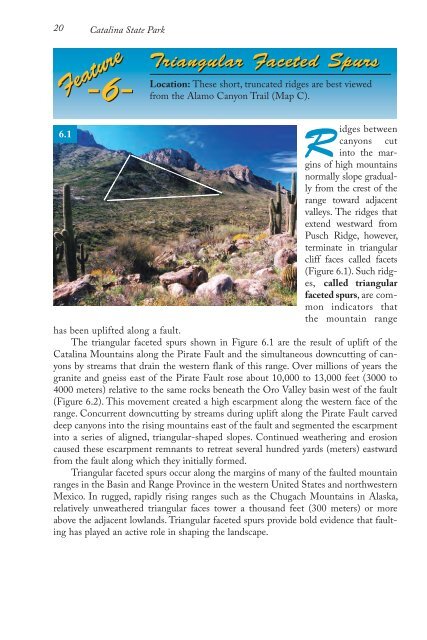
Triangular Faceted Spurs<br />
Location: These short, truncated ridges are best viewed<br />
from <strong>the</strong> Alamo Canyon Trail (Map C).<br />
Ridges between<br />
6.1<br />
canyons cut<br />
in<strong>to</strong> <strong>the</strong> margins<br />
<strong>of</strong> high mountains<br />
normally slope gradually<br />
from <strong>the</strong> crest <strong>of</strong> <strong>the</strong><br />
range <strong>to</strong>ward adjacent<br />
valleys. The ridges that<br />
extend westward from<br />
Pusch Ridge, however,<br />
terminate in triangular<br />
cliff faces called facets<br />
(Figure 6.1). Such ridges,<br />
called triangular<br />
faceted spurs, are common<br />
indica<strong>to</strong>rs that<br />
<strong>the</strong> mountain range<br />
has been uplifted along a fault.<br />
The triangular faceted spurs shown in Figure 6.1 are <strong>the</strong> result <strong>of</strong> uplift <strong>of</strong> <strong>the</strong><br />
<strong>Catalina</strong> Mountains along <strong>the</strong> Pirate Fault and <strong>the</strong> simultaneous downcutting <strong>of</strong> canyons<br />
by streams that drain <strong>the</strong> western flank <strong>of</strong> this range. Over millions <strong>of</strong> years <strong>the</strong><br />
granite and gneiss east <strong>of</strong> <strong>the</strong> Pirate Fault rose about 10,000 <strong>to</strong> 13,000 feet (3000 <strong>to</strong><br />
4000 meters) relative <strong>to</strong> <strong>the</strong> same rocks beneath <strong>the</strong> Oro Valley basin west <strong>of</strong> <strong>the</strong> fault<br />
(Figure 6.2). This movement created a high escarpment along <strong>the</strong> western face <strong>of</strong> <strong>the</strong><br />
range. Concurrent downcutting by streams during uplift along <strong>the</strong> Pirate Fault carved<br />
deep canyons in<strong>to</strong> <strong>the</strong> rising mountains east <strong>of</strong> <strong>the</strong> fault and segmented <strong>the</strong> escarpment<br />
in<strong>to</strong> a series <strong>of</strong> aligned, triangular-shaped slopes. Continued wea<strong>the</strong>ring and erosion<br />
caused <strong>the</strong>se escarpment remnants <strong>to</strong> retreat several hundred yards (meters) eastward<br />
from <strong>the</strong> fault along which <strong>the</strong>y initially formed.<br />
Triangular faceted spurs occur along <strong>the</strong> margins <strong>of</strong> many <strong>of</strong> <strong>the</strong> faulted mountain<br />
ranges in <strong>the</strong> Basin and Range Province in <strong>the</strong> western United <strong>State</strong>s and northwestern<br />
Mexico. In rugged, rapidly rising ranges such as <strong>the</strong> Chugach Mountains in Alaska,<br />
relatively unwea<strong>the</strong>red triangular faces <strong>to</strong>wer a thousand feet (300 meters) or more<br />
above <strong>the</strong> adjacent lowlands. Triangular faceted spurs provide bold evidence that faulting<br />
has played an active role in shaping <strong>the</strong> landscape.