

A Guide to the Geology of Catalina State - AZGS Document Repository
A Guide to the Geology of Catalina State - AZGS Document Repository
A Guide to the Geology of Catalina State - AZGS Document Repository

You also want an ePaper? Increase the reach of your titles
YUMPU automatically turns print PDFs into web optimized ePapers that Google loves.
22<br />
<strong>Catalina</strong> <strong>State</strong> Park<br />
-7-<br />
Feature Feature<br />
7.1<br />
F<br />
Fold<br />
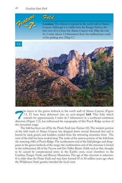
Location: This feature is exposed in <strong>the</strong> north wall <strong>of</strong> Alamo<br />
Canyon. Although it is visible from <strong>the</strong> Ranger Station, <strong>the</strong><br />
best view <strong>of</strong> it is from <strong>the</strong> Alamo Canyon trail. Hike <strong>the</strong> trail<br />
for 2 miles (about 3.2 kilometers) from <strong>the</strong> trailhead just south<br />
<strong>of</strong> <strong>the</strong> parking area. (Map C).<br />
The layers in <strong>the</strong> gneiss bedrock in <strong>the</strong> north wall <strong>of</strong> Alamo Canyon (Figure<br />
7.1, F) have been deformed in<strong>to</strong> an arch-shaped fold. This fold, which<br />
extends for approximately 4 miles (6-7 kilometers) in a nor<strong>the</strong>ast-southwest<br />
direction (Figure 7.2), has influenced <strong>the</strong> <strong>to</strong>pography <strong>of</strong> this Pusch Ridge section <strong>of</strong><br />
<strong>the</strong> mountain range.<br />
The fold has been cut <strong>of</strong>f by <strong>the</strong> Pirate Fault (see Feature 10). The western portion<br />
<strong>of</strong> <strong>the</strong> fold south <strong>of</strong> Alamo Canyon has dropped down several thousand feet and is<br />
buried by sand, gravel, and boulders eroded from <strong>the</strong> retreating mountain front. The<br />
crest <strong>of</strong> <strong>the</strong> fold has been eroded away. The rocks <strong>of</strong> <strong>the</strong> eastern portion <strong>of</strong> <strong>the</strong> fold form<br />
<strong>the</strong> <strong>to</strong>wering cliffs <strong>of</strong> Pusch Ridge. The nor<strong>the</strong>astern end <strong>of</strong> <strong>the</strong> fold plunges and disappears<br />
in <strong>the</strong> gneiss bedrock <strong>of</strong> <strong>the</strong> range; <strong>the</strong> southwestern end <strong>of</strong> <strong>the</strong> structure is buried<br />
in <strong>the</strong> sedimentary fill <strong>of</strong> <strong>the</strong> Tucson and Oro Valley Basins. Folds such as this, thought<br />
<strong>to</strong> be caused by compressional stress in <strong>the</strong> Earth’s crust, occur elsewhere in <strong>the</strong><br />
<strong>Catalina</strong>, Tanque Verde, and Rincon Mountains. The age <strong>of</strong> this structure is unknown.<br />
It is older than <strong>the</strong> Pirate Fault and may have formed 45 <strong>to</strong> 50 million years ago when<br />
<strong>the</strong> Wilderness Suite granite intruded <strong>the</strong> local crust.


