

tsunami inundation maps of whittier and western passage canal ...
tsunami inundation maps of whittier and western passage canal ...
tsunami inundation maps of whittier and western passage canal ...

Create successful ePaper yourself
Turn your PDF publications into a flip-book with our unique Google optimized e-Paper software.
34 Report <strong>of</strong> Investigations 2011-7<br />
148°40'30"W<br />
148°42'0"W<br />
60°47'30"N<br />
Scenario 1, Rupture <strong>of</strong> the 1964 earthquake, based on the JDM<br />
Scenario 2, Rupture <strong>of</strong> the 1964 earthquake, based on the SDM<br />
Scenario 5, Rupture <strong>of</strong> the Cascadia zone<br />
Scenario 13, combined slide<br />
Observed 1964 <strong>inundation</strong><br />
60°47'30"N<br />
Present-day MHHW shoreline<br />
0 125 250 500 meters<br />
0 0.125 0.25 0.5 miles<br />
60°47'0"N<br />
60°47'0"N<br />
60°46'30"N<br />
60°46'30"N<br />
148°40'30"W<br />
148°42'0"W<br />
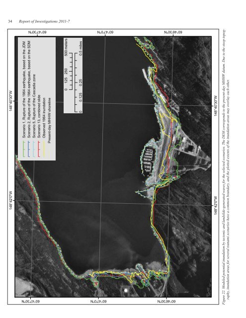
Figure 22. Modeled potential <strong>inundation</strong> by tectonic <strong>and</strong> l<strong>and</strong>slide-generated waves for the selected scenarios. The DEM corresponds to the present-day MHHW datum. Due to the steep topography,<br />
<strong>inundation</strong> areas for several <strong>tsunami</strong> scenarios have a common boundary, <strong>and</strong> the plotted extents <strong>of</strong> the <strong>inundation</strong> areas may overlay each other.


