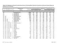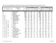
Table C-11: Distribution of Population aged 7 years ... - Bbs.gov.bd
Table C-11: Distribution of Population aged 7 years ... - Bbs.gov.bd
Table C-11: Distribution of Population aged 7 years ... - Bbs.gov.bd

Create successful ePaper yourself
Turn your PDF publications into a flip-book with our unique Google optimized e-Paper software.
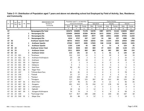
<strong>Table</strong> C-<strong>11</strong>: <strong>Distribution</strong> <strong>of</strong> <strong>Population</strong> <strong>aged</strong> 7 <strong>years</strong> and above not attending school but Employed by Field <strong>of</strong> Activity, Sex, Residence<br />
and Community<br />
ZL UZ<br />
UN /<br />
WA<br />
MZ /<br />
MH<br />
1<br />
Vill RMO<br />
Administrative Unit<br />
Residence<br />
Community<br />
<strong>Population</strong> <strong>aged</strong> 7+, not attending<br />
school and employed<br />
Field <strong>of</strong> Activity<br />
Agriculture Industry Service<br />
Both Male Female Male Female Male Female Male Female<br />
2 3 4 5 6 7 8 9 10 <strong>11</strong><br />
67 Narayanganj Zila Total 325273 254095 7<strong>11</strong>78 54278 1987 83773 4<strong>11</strong>64 <strong>11</strong>6044 28027<br />
67 1 Narayanganj Zila 229404 184020 45384 48134 1615 59262 27257 76624 16512<br />
67 2 Narayanganj Zila 91635 66348 25287 4977 348 23931 13680 37440 <strong>11</strong>259<br />
67 3 Narayanganj Zila 4234 3727 507 <strong>11</strong>67 24 580 227 1980 256<br />
67 02 Araihazar Upazila Total 48755 44425 4330 18242 544 <strong>11</strong>233 1826 14950 1960<br />
67 02 1 Araihazar Upazila 47562 43277 4285 17693 538 <strong>11</strong>158 1822 14426 1925<br />
67 02 3 Araihazar Upazila <strong>11</strong>93 <strong>11</strong>48 45 549 6 75 4 524 35<br />
67 02 23 Araihazar Union Total 3524 3020 504 869 47 1023 284 <strong>11</strong>28 173<br />
67 02 23 1 Araihazar Union 33<strong>11</strong> 2829 482 863 46 982 282 984 154<br />
67 02 23 3 Araihazar Union 213 191 22 6 1 41 2 144 19<br />
67 02 23 021 3 *Araihazar 132 <strong>11</strong>0 22 5 1 39 2 66 19<br />
67 02 23 021 01 3 Araihazar Krishnapura 20 18 2 0 0 2 1 16 1<br />
67 02 23 021 02 3 Araihazar 67 53 14 2 1 17 0 34 13<br />
67 02 23 021 03 3 Dighirpar 2 2 0 0 0 0 0 2 0<br />
67 02 23 021 04 3 Debipura 6 5 1 1 0 3 1 1 0<br />
67 02 23 021 05 3 Goal Para 30 25 5 0 0 13 0 12 5<br />
67 02 23 021 06 3 Nagar Para 7 7 0 2 0 4 0 1 0<br />
67 02 23 247 3 *Chhota Barai Para 81 81 0 1 0 2 0 78 0<br />
67 02 23 376 1 *Faitadi 23 17 6 7 0 5 3 5 3<br />
67 02 23 403 1 *Gazipur 120 100 20 9 2 47 16 44 2<br />
67 02 23 467 1 *Jhaugara 717 602 <strong>11</strong>5 267 25 212 60 123 30<br />
67 02 23 467 01 1 Binar Char 127 96 31 29 4 21 1 46 26<br />
67 02 23 467 02 1 Jhaugara 491 412 79 216 17 178 59 18 3<br />
67 02 23 467 03 1 Lakhupura 7 4 3 3 3 1 0 0 0<br />
67 02 23 467 04 1 Dighaldi 18 16 2 12 1 3 0 1 1<br />
67 02 23 467 05 1 Jhaugara Krishnapura 74 74 0 7 0 9 0 58 0<br />
67 02 23 559 1 *Kamrangir Char 917 817 100 240 5 230 65 347 30<br />
67 02 23 559 01 1 Majar Char 95 86 9 57 1 <strong>11</strong> 7 18 1<br />
RMO: 1 = Rural, 2 = Urban and 3 = Other Urban<br />
Page 1 <strong>of</strong> 66
<strong>Table</strong> C-<strong>11</strong>: <strong>Distribution</strong> <strong>of</strong> <strong>Population</strong> <strong>aged</strong> 7 <strong>years</strong> and above not attending school but Employed by Field <strong>of</strong> Activity, Sex, Residence<br />
and Community<br />
ZL UZ<br />
UN /<br />
WA<br />
MZ /<br />
MH<br />
1<br />
Vill RMO<br />
Administrative Unit<br />
Residence<br />
Community<br />
<strong>Population</strong> <strong>aged</strong> 7+, not attending<br />
school and employed<br />
Field <strong>of</strong> Activity<br />
Agriculture Industry Service<br />
Both Male Female Male Female Male Female Male Female<br />
2 3 4 5 6 7 8 9 10 <strong>11</strong><br />
67 02 23 559 02 1 Kamrangir Char 195 176 19 56 4 49 <strong>11</strong> 71 4<br />
67 02 23 559 03 1 Hatkhola 81 80 1 24 0 <strong>11</strong> 0 45 1<br />
67 02 23 559 04 1 Daspara 218 201 17 46 0 58 3 97 14<br />
67 02 23 559 05 1 Chamirkandi 184 148 36 39 0 52 34 57 2<br />
67 02 23 559 06 1 Mougakanda 144 126 18 18 0 49 10 59 8<br />
67 02 23 586 1 *Krishnapura 332 281 51 14 2 225 42 42 7<br />
67 02 23 683 1 *Mirka (Baganagar) 2<strong>11</strong> 190 21 106 6 61 12 23 3<br />
67 02 23 693 1 *Mukundi 241 198 43 37 1 65 25 96 17<br />
67 02 23 693 01 1 Mukundi 142 123 19 18 0 40 <strong>11</strong> 65 8<br />
67 02 23 693 02 1 Panna Baraipara 99 75 24 19 1 25 14 31 9<br />
67 02 23 715 1 *Nager Char <strong>11</strong>9 109 10 1 0 0 0 108 10<br />
67 02 23 747 1 *Noapara 513 414 99 163 5 107 54 144 40<br />
67 02 23 747 01 1 Noapara 452 356 96 152 5 104 53 100 38<br />
67 02 23 747 02 1 A<strong>bd</strong>ullapur 61 58 3 <strong>11</strong> 0 3 1 44 2<br />
67 02 23 871 1 *Shibpur <strong>11</strong>8 101 17 19 0 30 5 52 12<br />
67 02 26 Bishnandi Union Total 6041 5700 341 2521 75 2206 164 973 102<br />
67 02 26 172 1 *Bishnandi <strong>11</strong>10 1029 81 294 <strong>11</strong> 506 41 229 29<br />
67 02 26 172 01 1 P.Bishnandi 501 466 35 <strong>11</strong>3 5 302 20 51 10<br />
67 02 26 172 02 1 Purbapara 355 324 31 97 4 153 10 74 17<br />
67 02 26 172 03 1 Kala Para <strong>11</strong>4 <strong>11</strong>1 3 19 0 1 1 91 2<br />
67 02 26 172 04 1 Chaler Char 140 128 12 65 2 50 10 13 0<br />
67 02 26 209 1 *Chaitankandi 10<strong>11</strong> 952 59 553 26 171 13 228 20<br />
67 02 26 301 1 *Dari Bishnandi 574 552 22 156 2 255 10 141 10<br />
67 02 26 301 01 1 Dari Bishnandi 339 324 15 79 2 <strong>11</strong>6 3 129 10<br />
67 02 26 301 02 1 Naya Para 235 228 7 77 0 139 7 12 0<br />
67 02 26 333 1 *Dayakanda 1037 1015 22 752 16 237 5 26 1<br />
67 02 26 333 01 1 Dayakanda 791 770 21 574 16 170 4 26 1<br />
67 02 26 333 02 1 Naya Para 82 81 1 23 0 58 1 0 0<br />
RMO: 1 = Rural, 2 = Urban and 3 = Other Urban<br />
Page 2 <strong>of</strong> 66
<strong>Table</strong> C-<strong>11</strong>: <strong>Distribution</strong> <strong>of</strong> <strong>Population</strong> <strong>aged</strong> 7 <strong>years</strong> and above not attending school but Employed by Field <strong>of</strong> Activity, Sex, Residence<br />
and Community<br />
ZL UZ<br />
UN /<br />
WA<br />
MZ /<br />
MH<br />
1<br />
Vill RMO<br />
Administrative Unit<br />
Residence<br />
Community<br />
<strong>Population</strong> <strong>aged</strong> 7+, not attending<br />
school and employed<br />
Field <strong>of</strong> Activity<br />
Agriculture Industry Service<br />
Both Male Female Male Female Male Female Male Female<br />
2 3 4 5 6 7 8 9 10 <strong>11</strong><br />
67 02 26 333 03 1 Kanda Para 83 83 0 74 0 9 0 0 0<br />
67 02 26 333 04 1 Chandanpura 81 81 0 81 0 0 0 0 0<br />
67 02 26 408 1 *Gazipura 632 580 52 78 1 427 43 75 8<br />
67 02 26 408 01 1 Gazipura 413 375 38 56 1 283 32 36 5<br />
67 02 26 408 02 1 Baluakandi 219 205 14 22 0 144 <strong>11</strong> 39 3<br />
67 02 26 564 1 *Karaitala 794 715 79 179 12 368 43 168 24<br />
67 02 26 564 01 1 Karaitala 386 352 34 80 3 125 15 147 16<br />
67 02 26 564 02 1 Sharifpur 217 200 17 61 5 120 8 19 4<br />
67 02 26 564 03 1 Panchkania 141 <strong>11</strong>3 28 26 4 86 20 1 4<br />
67 02 26 564 04 1 Roypura 50 50 0 12 0 37 0 1 0<br />
67 02 26 666 1 *Manikpur 478 462 16 208 2 192 6 62 8<br />
67 02 26 849 1 *Sambhupura 181 176 5 145 5 25 0 6 0<br />
67 02 26 941 1 *Tetia 96 96 0 91 0 0 0 5 0<br />
67 02 26 984 1 *Ulukanda 128 123 5 65 0 25 3 33 2<br />
67 02 29 Brahmandi Union Total 5422 4764 658 <strong>11</strong>66 34 889 354 2709 270<br />
67 02 29 086 1 *Balia Para 534 460 74 82 4 56 25 322 45<br />
67 02 29 086 01 1 Balia Para 428 369 59 39 0 48 17 282 42<br />
67 02 29 086 02 1 Kadamdi 29 28 1 8 0 1 0 19 1<br />
67 02 29 086 03 1 Bhartibalia Para 77 63 14 35 4 7 8 21 2<br />
67 02 29 <strong>11</strong>2 1 *Bara Manohardi 329 284 45 54 0 100 40 130 5<br />
67 02 29 139 1 *Bhati Gobindi 52 43 9 19 0 1 4 23 5<br />
67 02 29 166 1 *Binair Char 491 437 54 102 0 80 40 255 14<br />
67 02 29 188 1 *Brahmandi 438 394 44 96 9 45 13 253 22<br />
67 02 29 263 1 *Chhota Manohardi 10 6 4 1 0 2 2 3 2<br />
67 02 29 360 1 *Dighaldi 81 65 16 13 0 15 13 37 3<br />
67 02 29 371 1 *Edbardi 390 367 23 92 0 31 6 244 17<br />
67 02 29 371 01 1 Edbardi 224 214 10 71 0 20 4 123 6<br />
67 02 29 371 02 1 Utrapur 166 153 13 21 0 <strong>11</strong> 2 121 <strong>11</strong><br />
RMO: 1 = Rural, 2 = Urban and 3 = Other Urban<br />
Page 3 <strong>of</strong> 66
<strong>Table</strong> C-<strong>11</strong>: <strong>Distribution</strong> <strong>of</strong> <strong>Population</strong> <strong>aged</strong> 7 <strong>years</strong> and above not attending school but Employed by Field <strong>of</strong> Activity, Sex, Residence<br />
and Community<br />
ZL UZ<br />
UN /<br />
WA<br />
MZ /<br />
MH<br />
1<br />
Vill RMO<br />
Administrative Unit<br />
Residence<br />
Community<br />
<strong>Population</strong> <strong>aged</strong> 7+, not attending<br />
school and employed<br />
Field <strong>of</strong> Activity<br />
Agriculture Industry Service<br />
Both Male Female Male Female Male Female Male Female<br />
2 3 4 5 6 7 8 9 10 <strong>11</strong><br />
67 02 29 381 1 *Fausa 470 420 50 122 5 <strong>11</strong>0 27 188 18<br />
67 02 29 462 1 *Jatrabari (Bailarkandi) 135 122 13 40 0 39 <strong>11</strong> 43 2<br />
67 02 29 591 1 *Kumarbagh 72 66 6 19 0 17 3 30 3<br />
67 02 29 623 1 *Laskardi 681 622 59 149 5 74 28 399 26<br />
67 02 29 634 1 *Lengardi 133 <strong>11</strong>2 21 23 2 4 1 85 18<br />
67 02 29 677 1 *Maruadi 579 475 104 98 5 108 56 269 43<br />
67 02 29 704 1 *Muraldi 4 4 0 2 0 1 0 1 0<br />
67 02 29 726 1 *Narindi 233 201 32 52 1 73 16 76 15<br />
67 02 29 742 1 *Noadda 52 44 8 <strong>11</strong> 0 13 6 20 2<br />
67 02 29 752 1 *Pajaradia 55 54 1 20 0 15 0 19 1<br />
67 02 29 785 1 *Prabhakardi 187 173 14 40 0 16 12 <strong>11</strong>7 2<br />
67 02 29 833 1 *Rishir Char 51 51 0 35 0 2 0 14 0<br />
67 02 29 874 1 *Silmondi Para 120 108 12 41 2 <strong>11</strong> 4 56 6<br />
67 02 29 925 1 *Sulpandi 31 27 4 15 1 8 3 4 0<br />
67 02 29 978 1 *Ujan Gobindi 294 229 65 40 0 68 44 121 21<br />
67 02 31 Duptara Union Total 3536 3<strong>11</strong>6 420 1012 55 506 44 1598 321<br />
67 02 31 069 1 *Bajbi 262 238 24 71 0 14 1 153 23<br />
67 02 31 069 01 1 Bajbi <strong>11</strong>7 <strong>11</strong>3 4 39 0 13 0 61 4<br />
67 02 31 069 02 1 Purbapara 56 41 15 4 0 0 0 37 15<br />
67 02 31 069 03 1 Tati Para 89 84 5 28 0 1 1 55 4<br />
67 02 31 096 1 *Banti 6<strong>11</strong> 497 <strong>11</strong>4 182 34 263 7 52 73<br />
67 02 31 365 1 *Duptara 1361 1224 137 308 9 72 12 844 <strong>11</strong>6<br />
67 02 31 365 01 1 Hatkhola Para 79 66 13 35 2 9 3 22 8<br />
67 02 31 365 02 1 Kalibari Bazar 12 12 0 1 0 0 0 <strong>11</strong> 0<br />
67 02 31 365 03 1 Patita Para 18 15 3 1 0 0 0 14 3<br />
67 02 31 365 04 1 Kumar Para 132 109 23 13 0 5 0 91 23<br />
67 02 31 365 05 1 Khan Para 69 68 1 50 0 2 0 16 1<br />
67 02 31 365 06 1 Ragha<strong>bd</strong>i 97 85 12 5 0 13 6 67 6<br />
RMO: 1 = Rural, 2 = Urban and 3 = Other Urban<br />
Page 4 <strong>of</strong> 66
<strong>Table</strong> C-<strong>11</strong>: <strong>Distribution</strong> <strong>of</strong> <strong>Population</strong> <strong>aged</strong> 7 <strong>years</strong> and above not attending school but Employed by Field <strong>of</strong> Activity, Sex, Residence<br />
and Community<br />
ZL UZ<br />
UN /<br />
WA<br />
MZ /<br />
MH<br />
1<br />
Vill RMO<br />
Administrative Unit<br />
Residence<br />
Community<br />
<strong>Population</strong> <strong>aged</strong> 7+, not attending<br />
school and employed<br />
Field <strong>of</strong> Activity<br />
Agriculture Industry Service<br />
Both Male Female Male Female Male Female Male Female<br />
2 3 4 5 6 7 8 9 10 <strong>11</strong><br />
67 02 31 365 07 1 Singrati 144 139 5 <strong>11</strong>5 3 0 0 24 2<br />
67 02 31 365 08 1 Nutan Banti 80 80 0 32 0 19 0 29 0<br />
67 02 31 365 09 1 Malpara 131 122 9 4 0 0 0 <strong>11</strong>8 9<br />
67 02 31 365 10 1 Chowdhury Para 97 85 12 15 0 0 0 70 12<br />
67 02 31 365 <strong>11</strong> 1 Girda Para 172 146 26 14 1 16 3 <strong>11</strong>6 22<br />
67 02 31 365 12 1 Nagar Para 50 50 0 0 0 1 0 49 0<br />
67 02 31 365 13 1 Rishi Para 139 <strong>11</strong>7 22 1 0 0 0 <strong>11</strong>6 22<br />
67 02 31 365 14 1 Kathalia Para 59 57 2 4 0 0 0 53 2<br />
67 02 31 365 15 1 Paschimpara 82 73 9 18 3 7 0 48 6<br />
67 02 31 758 1 *Palla 83 73 10 27 2 37 2 9 6<br />
67 02 31 763 1 *Panchgaon 783 699 84 366 8 86 20 247 56<br />
67 02 31 763 01 1 Manehar 36 33 3 15 0 0 1 18 2<br />
67 02 31 763 02 1 Char Para 205 172 33 93 4 20 9 59 20<br />
67 02 31 763 03 1 Karmakar Para 26 26 0 3 0 0 0 23 0<br />
67 02 31 763 04 1 Dewan Para 3 2 1 0 0 0 0 2 1<br />
67 02 31 763 05 1 Nayapara 96 82 14 46 1 7 0 29 13<br />
67 02 31 763 06 1 Mollah Para 141 124 17 48 1 21 0 55 16<br />
67 02 31 763 07 1 Panchbaria 276 260 16 161 2 38 10 61 4<br />
67 02 31 860 1 *Satyabhandi 379 337 42 53 2 34 2 250 38<br />
67 02 31 860 01 1 Dari Satyabhandi 256 225 31 27 2 20 2 178 27<br />
67 02 31 860 02 1 Nayapara 3 2 1 0 0 0 0 2 1<br />
67 02 31 860 03 1 Bhuyan Para 88 81 7 15 0 12 0 54 7<br />
67 02 31 860 04 1 Mollah Para 32 29 3 <strong>11</strong> 0 2 0 16 3<br />
67 02 31 951 1 *Tingaon 57 48 9 5 0 0 0 43 9<br />
67 02 31 951 01 1 Tingaon 50 44 6 5 0 0 0 39 6<br />
67 02 31 951 02 1 Duptara Bazar 7 4 3 0 0 0 0 4 3<br />
67 02 39 Fatehpur Union Total 3136 2853 283 910 31 961 138 982 <strong>11</strong>4<br />
67 02 39 005 1 *Agar Para <strong>11</strong>1 100 <strong>11</strong> 14 0 0 0 86 <strong>11</strong><br />
RMO: 1 = Rural, 2 = Urban and 3 = Other Urban<br />
Page 5 <strong>of</strong> 66
<strong>Table</strong> C-<strong>11</strong>: <strong>Distribution</strong> <strong>of</strong> <strong>Population</strong> <strong>aged</strong> 7 <strong>years</strong> and above not attending school but Employed by Field <strong>of</strong> Activity, Sex, Residence<br />
and Community<br />
ZL UZ<br />
UN /<br />
WA<br />
MZ /<br />
MH<br />
1<br />
Vill RMO<br />
Administrative Unit<br />
Residence<br />
Community<br />
<strong>Population</strong> <strong>aged</strong> 7+, not attending<br />
school and employed<br />
Field <strong>of</strong> Activity<br />
Agriculture Industry Service<br />
Both Male Female Male Female Male Female Male Female<br />
2 3 4 5 6 7 8 9 10 <strong>11</strong><br />
67 02 39 043 1 *Bagadi 357 332 25 53 1 63 9 216 15<br />
67 02 39 043 01 1 Bagadi 296 281 15 41 1 54 1 186 13<br />
67 02 39 043 02 1 Dakshinpara 61 51 10 12 0 9 8 30 2<br />
67 02 39 048 1 *Bagadi Noapara 77 73 4 17 0 39 0 17 4<br />
67 02 39 048 01 1 Bagadi Noapara 71 67 4 16 0 39 0 12 4<br />
67 02 39 048 02 1 Jalakandi 6 6 0 1 0 0 0 5 0<br />
67 02 39 053 1 *Baganagar 0 0 0 0 0 0 0 0 0<br />
67 02 39 059 1 *Bailat 121 <strong>11</strong>1 10 66 2 27 3 18 5<br />
67 02 39 075 1 *Balarampur 8 8 0 4 0 4 0 0 0<br />
67 02 39 107 1 *Barakanda 127 <strong>11</strong>5 12 38 0 41 7 36 5<br />
67 02 39 107 01 1 Kanda Para <strong>11</strong>5 106 9 35 0 40 6 31 3<br />
67 02 39 107 02 1 Dakshinpara 12 9 3 3 0 1 1 5 2<br />
67 02 39 193 1 *Brahman Para 85 79 6 33 1 25 2 21 3<br />
67 02 39 231 1 *Chautharkhanda 449 400 49 222 <strong>11</strong> 68 16 <strong>11</strong>0 22<br />
67 02 39 231 01 1 Chautharkhanda 27 25 2 15 1 9 1 1 0<br />
67 02 39 231 02 1 Nayakhanda 121 <strong>11</strong>2 9 81 4 14 2 17 3<br />
67 02 39 231 03 1 Akhar Para 241 204 37 79 6 34 13 91 18<br />
67 02 39 231 04 1 Nagarjoar 60 59 1 47 0 <strong>11</strong> 0 1 1<br />
67 02 39 252 1 *Chhota Daburpura 9 9 0 3 0 3 0 3 0<br />
67 02 39 258 1 *Chhota Khamar Char(D.Para 169 156 13 39 0 76 7 41 6<br />
67 02 39 268 1 *Chhota Sadardia 157 147 10 32 0 2 0 <strong>11</strong>3 10<br />
67 02 39 279 1 *Daburpura 140 124 16 26 2 73 <strong>11</strong> 25 3<br />
67 02 39 290 1 *Dakshinpara 159 155 4 45 2 100 2 10 0<br />
67 02 39 3<strong>11</strong> 1 *Dari Para 122 <strong>11</strong>0 12 48 0 44 <strong>11</strong> 18 1<br />
67 02 39 387 1 *Fatehpur 152 131 21 50 2 61 13 20 6<br />
67 02 39 478 1 *Joar Hamchadi 154 129 25 29 1 40 22 60 2<br />
67 02 39 613 1 *Lalurkandi 101 94 7 41 1 47 4 6 2<br />
67 02 39 618 1 *Lasardi 102 88 14 3 0 18 2 67 12<br />
RMO: 1 = Rural, 2 = Urban and 3 = Other Urban<br />
Page 6 <strong>of</strong> 66
<strong>Table</strong> C-<strong>11</strong>: <strong>Distribution</strong> <strong>of</strong> <strong>Population</strong> <strong>aged</strong> 7 <strong>years</strong> and above not attending school but Employed by Field <strong>of</strong> Activity, Sex, Residence<br />
and Community<br />
ZL UZ<br />
UN /<br />
WA<br />
MZ /<br />
MH<br />
1<br />
Vill RMO<br />
Administrative Unit<br />
Residence<br />
Community<br />
<strong>Population</strong> <strong>aged</strong> 7+, not attending<br />
school and employed<br />
Field <strong>of</strong> Activity<br />
Agriculture Industry Service<br />
Both Male Female Male Female Male Female Male Female<br />
2 3 4 5 6 7 8 9 10 <strong>11</strong><br />
67 02 39 618 01 1 Goal Para 71 60 <strong>11</strong> 0 0 4 0 56 <strong>11</strong><br />
67 02 39 618 02 1 Dakshinpara 31 28 3 3 0 14 2 <strong>11</strong> 1<br />
67 02 39 629 1 *Lata<strong>bd</strong>i 126 <strong>11</strong>2 14 22 3 62 9 28 2<br />
67 02 39 720 1 *Naikahan <strong>11</strong>5 103 12 56 4 41 6 6 2<br />
67 02 39 882 1 *Singapur 72 69 3 10 0 47 3 12 0<br />
67 02 39 930 1 *Sultansadi 184 172 12 56 1 65 9 51 2<br />
67 02 39 962 1 *Turkini 39 36 3 3 0 15 2 18 1<br />
67 02 47 Haizadi Union Total 3427 3155 272 1920 45 485 153 750 74<br />
67 02 47 032 1 *Atadi 48 44 4 27 1 0 0 17 3<br />
67 02 47 091 1 *Ballabhdi 191 185 6 <strong>11</strong>2 1 33 3 40 2<br />
67 02 47 091 01 1 Ballabhdi 79 75 4 51 1 17 1 7 2<br />
67 02 47 091 02 1 Ballabhdi Khanda 85 84 1 39 0 13 1 32 0<br />
67 02 47 091 03 1 Barujkhanda 27 26 1 22 0 3 1 1 0<br />
67 02 47 150 1 *Bhiti Kamaldi 109 94 15 50 0 <strong>11</strong> 9 33 6<br />
67 02 47 150 01 1 Bhiti Kamaldi 41 40 1 32 0 1 0 7 1<br />
67 02 47 150 02 1 Para Manohardi 68 54 14 18 0 10 9 26 5<br />
67 02 47 274 1 *Chhota Salmadi 48 44 4 36 0 2 0 6 4<br />
67 02 47 274 01 1 Chhota Salmadi 21 19 2 17 0 1 0 1 2<br />
67 02 47 274 02 1 Salmadi 27 25 2 19 0 1 0 5 2<br />
67 02 47 295 1 *Daldi 61 60 1 20 0 0 0 40 1<br />
67 02 47 306 1 *Dariabad 67 55 12 35 0 16 <strong>11</strong> 4 1<br />
67 02 47 349 1 *Dhandi 25 23 2 20 0 3 2 0 0<br />
67 02 47 354 1 *Dhandi Udaydi (Baroani) 30 26 4 16 1 1 2 9 1<br />
67 02 47 392 1 *Gadadhardi <strong>11</strong>2 <strong>11</strong>0 2 78 0 9 1 23 1<br />
67 02 47 392 01 1 Gadadhardi 17 16 1 13 0 2 0 1 1<br />
67 02 47 392 02 1 Chandibardi 42 41 1 34 0 5 1 2 0<br />
67 02 47 392 03 1 Saizadi 53 53 0 31 0 2 0 20 0<br />
67 02 47 424 1 *Haji Sahadi 289 279 10 217 2 40 6 22 2<br />
RMO: 1 = Rural, 2 = Urban and 3 = Other Urban<br />
Page 7 <strong>of</strong> 66
<strong>Table</strong> C-<strong>11</strong>: <strong>Distribution</strong> <strong>of</strong> <strong>Population</strong> <strong>aged</strong> 7 <strong>years</strong> and above not attending school but Employed by Field <strong>of</strong> Activity, Sex, Residence<br />
and Community<br />
ZL UZ<br />
UN /<br />
WA<br />
MZ /<br />
MH<br />
1<br />
Vill RMO<br />
Administrative Unit<br />
Residence<br />
Community<br />
<strong>Population</strong> <strong>aged</strong> 7+, not attending<br />
school and employed<br />
Field <strong>of</strong> Activity<br />
Agriculture Industry Service<br />
Both Male Female Male Female Male Female Male Female<br />
2 3 4 5 6 7 8 9 10 <strong>11</strong><br />
67 02 47 424 01 1 Hazadi 31 31 0 18 0 3 0 10 0<br />
67 02 47 424 02 1 Nayapara 160 152 8 145 2 6 5 1 1<br />
67 02 47 424 03 1 Singhadirkanda 59 57 2 27 0 25 1 5 1<br />
67 02 47 424 04 1 Apardi 39 39 0 27 0 6 0 6 0<br />
67 02 47 435 1 *Ilamdi (Khondakarkandi) 99 90 9 37 1 18 8 35 0<br />
67 02 47 441 1 *Isirchak 1 1 0 1 0 0 0 0 0<br />
67 02 47 510 1 *Kahindi 386 348 38 234 9 65 27 49 2<br />
67 02 47 510 01 1 Kahindi 237 212 25 103 3 64 21 45 1<br />
67 02 47 510 02 1 Khandakar Kalagachhia 105 96 9 95 3 1 5 0 1<br />
67 02 47 510 03 1 Ramnagar 44 40 4 36 3 0 1 4 0<br />
67 02 47 527 1 *Kalagachhia 302 290 12 217 4 50 7 23 1<br />
67 02 47 527 01 1 Kalagachhia 250 241 9 190 4 36 4 15 1<br />
67 02 47 527 02 1 Nagarjoar 52 49 3 27 0 14 3 8 0<br />
67 02 47 553 1 *Kamaldi 457 405 52 200 5 38 26 167 21<br />
67 02 47 553 01 1 Daria Singapur 62 55 7 52 2 3 5 0 0<br />
67 02 47 553 02 1 Narandi 375 336 39 141 3 34 20 161 16<br />
67 02 47 553 03 1 Sultansadi 7 6 1 1 0 0 1 5 0<br />
67 02 47 553 04 1 Ilamdi 13 8 5 6 0 1 0 1 5<br />
67 02 47 645 1 *Madha<strong>bd</strong>i 330 307 23 199 <strong>11</strong> 44 7 64 5<br />
67 02 47 645 01 1 Madha<strong>bd</strong>i 143 135 8 61 1 24 5 50 2<br />
67 02 47 645 02 1 Ilamdi Kandapara 168 154 14 123 10 20 1 <strong>11</strong> 3<br />
67 02 47 645 03 1 Daldirkanda 19 18 1 15 0 0 1 3 0<br />
67 02 47 806 1 *Roynadi 147 144 3 85 1 23 2 36 0<br />
67 02 47 806 01 1 Roynadi 22 22 0 15 0 1 0 6 0<br />
67 02 47 806 02 1 Tuterbhag 84 83 1 41 0 17 1 25 0<br />
67 02 47 806 03 1 Paschim Sarapdi 38 36 2 26 1 5 1 5 0<br />
67 02 47 806 04 1 Purba Sarapdi 3 3 0 3 0 0 0 0 0<br />
67 02 47 865 1 *Sendi 244 232 12 120 1 34 4 78 7<br />
RMO: 1 = Rural, 2 = Urban and 3 = Other Urban<br />
Page 8 <strong>of</strong> 66
<strong>Table</strong> C-<strong>11</strong>: <strong>Distribution</strong> <strong>of</strong> <strong>Population</strong> <strong>aged</strong> 7 <strong>years</strong> and above not attending school but Employed by Field <strong>of</strong> Activity, Sex, Residence<br />
and Community<br />
ZL UZ<br />
UN /<br />
WA<br />
MZ /<br />
MH<br />
1<br />
Vill RMO<br />
Administrative Unit<br />
Residence<br />
Community<br />
<strong>Population</strong> <strong>aged</strong> 7+, not attending<br />
school and employed<br />
Field <strong>of</strong> Activity<br />
Agriculture Industry Service<br />
Both Male Female Male Female Male Female Male Female<br />
2 3 4 5 6 7 8 9 10 <strong>11</strong><br />
67 02 47 865 01 1 Sendi 181 172 9 96 0 18 3 58 6<br />
67 02 47 865 02 1 Sendi Hajibari 63 60 3 24 1 16 1 20 1<br />
67 02 47 887 1 *Singhadi 157 148 9 97 3 23 3 28 3<br />
67 02 47 887 01 1 Singhadi 127 <strong>11</strong>9 8 90 3 23 3 6 2<br />
67 02 47 887 02 1 Asarampur 30 29 1 7 0 0 0 22 1<br />
67 02 47 946 1 *Tilchandi 148 121 27 62 3 15 <strong>11</strong> 44 13<br />
67 02 47 973 1 *Udaydi 176 149 27 57 2 60 24 32 1<br />
67 02 55 Kala Paharia Union Total 3973 3791 182 3502 <strong>11</strong>7 96 7 193 58<br />
67 02 55 155 1 *Bibirkandi 88 88 0 72 0 2 0 14 0<br />
67 02 55 331 1 *Hat Chaker Kindi 154 148 6 148 6 0 0 0 0<br />
67 02 55 473 1 *Jhukandi 723 7<strong>11</strong> 12 639 5 17 5 55 2<br />
67 02 55 473 01 1 Jhukandi 303 301 2 292 2 0 0 9 0<br />
67 02 55 473 02 1 Madhyachar 186 178 8 153 1 16 5 9 2<br />
67 02 55 473 03 1 Purbakandi 234 232 2 194 2 1 0 37 0<br />
67 02 55 500 1 *Kadmir Char 391 385 6 373 4 3 1 9 1<br />
67 02 55 500 01 1 Kadmir Char 293 287 6 275 4 3 1 9 1<br />
67 02 55 500 02 1 Badalpur 98 98 0 98 0 0 0 0 0<br />
67 02 55 532 1 *Kalapaharia 644 606 38 550 36 35 0 21 2<br />
67 02 55 532 01 1 Kalapaharia 421 403 18 381 17 5 0 17 1<br />
67 02 55 532 02 1 Noagaon 223 203 20 169 19 30 0 4 1<br />
67 02 55 736 1 *Nij Kala Paharia 1973 1853 120 1720 66 39 1 94 53<br />
67 02 55 736 01 1 Ezarkandi 347 319 28 281 <strong>11</strong> 3 0 35 17<br />
67 02 55 736 02 1 Gobindapur <strong>11</strong>3 108 5 101 1 0 0 7 4<br />
67 02 55 736 03 1 Radhanagar 322 301 21 259 10 24 1 18 10<br />
67 02 55 736 04 1 Hazirtek 273 249 24 242 24 3 0 4 0<br />
67 02 55 736 05 1 Ulukandi 164 162 2 160 2 1 0 1 0<br />
67 02 55 736 06 1 Khaliar Char 601 565 36 542 17 1 0 22 19<br />
67 02 55 736 07 1 Chan Kasimpur 78 76 2 74 1 2 0 0 1<br />
RMO: 1 = Rural, 2 = Urban and 3 = Other Urban<br />
Page 9 <strong>of</strong> 66
<strong>Table</strong> C-<strong>11</strong>: <strong>Distribution</strong> <strong>of</strong> <strong>Population</strong> <strong>aged</strong> 7 <strong>years</strong> and above not attending school but Employed by Field <strong>of</strong> Activity, Sex, Residence<br />
and Community<br />
ZL UZ<br />
UN /<br />
WA<br />
MZ /<br />
MH<br />
1<br />
Vill RMO<br />
Administrative Unit<br />
Residence<br />
Community<br />
<strong>Population</strong> <strong>aged</strong> 7+, not attending<br />
school and employed<br />
Field <strong>of</strong> Activity<br />
Agriculture Industry Service<br />
Both Male Female Male Female Male Female Male Female<br />
2 3 4 5 6 7 8 9 10 <strong>11</strong><br />
67 02 55 736 08 1 Ali Pura 75 73 2 61 0 5 0 7 2<br />
67 02 63 Khagakanda Union Total 3023 2891 132 2089 41 453 53 349 38<br />
67 02 63 220 1 *Char Kamalapur 370 353 17 340 13 4 0 9 4<br />
67 02 63 220 01 1 Kamalapur 101 97 4 91 3 4 0 2 1<br />
67 02 63 220 02 1 Dengurkandi 269 256 13 249 10 0 0 7 3<br />
67 02 63 521 1 *Kakailmora 294 267 27 158 2 32 17 77 8<br />
67 02 63 602 1 *Lakshmipur 58 52 6 33 2 15 3 4 1<br />
67 02 63 731 1 *Nayanabad 2192 2<strong>11</strong>6 76 1532 24 347 32 237 20<br />
67 02 63 731 01 1 Sambhupura 49 47 2 40 0 3 2 4 0<br />
67 02 63 731 02 1 Mohanpura 189 177 12 94 0 64 9 19 3<br />
67 02 63 731 03 1 Nijar Para 42 40 2 29 0 1 1 10 1<br />
67 02 63 731 04 1 Dumar Char 44 43 1 30 0 0 0 13 1<br />
67 02 63 731 05 1 Naya Para 23 23 0 19 0 2 0 2 0<br />
67 02 63 731 06 1 Panchani <strong>11</strong>8 <strong>11</strong>4 4 65 1 3 1 46 2<br />
67 02 63 731 07 1 Kadamtali 97 96 1 61 0 27 1 8 0<br />
67 02 63 731 08 1 Tatuakanda (Ka) 70 68 2 64 2 0 0 4 0<br />
67 02 63 731 09 1 Lalurkandi 95 92 3 83 3 9 0 0 0<br />
67 02 63 731 10 1 Manikpur 47 40 7 27 6 10 0 3 1<br />
67 02 63 731 <strong>11</strong> 1 Aganagar 63 61 2 45 0 14 1 2 1<br />
67 02 63 731 12 1 Champaknagar <strong>11</strong>2 105 7 92 0 13 7 0 0<br />
67 02 63 731 13 1 Baher Char 93 92 1 57 0 24 0 <strong>11</strong> 1<br />
67 02 63 731 14 1 Tataytala 96 92 4 37 0 36 2 19 2<br />
67 02 63 731 15 1 Nayanabad 152 148 4 141 4 6 0 1 0<br />
67 02 63 731 16 1 Lalnagar 146 146 0 90 0 30 0 26 0<br />
67 02 63 731 17 1 Najarpura 31 31 0 17 0 12 0 2 0<br />
67 02 63 731 18 1 Islampur 37 35 2 26 1 2 1 7 0<br />
67 02 63 731 19 1 Hoglakanda 69 65 4 60 1 4 0 1 3<br />
67 02 63 731 20 1 Khagkanda 226 218 8 135 2 46 3 37 3<br />
RMO: 1 = Rural, 2 = Urban and 3 = Other Urban<br />
Page 10 <strong>of</strong> 66
<strong>Table</strong> C-<strong>11</strong>: <strong>Distribution</strong> <strong>of</strong> <strong>Population</strong> <strong>aged</strong> 7 <strong>years</strong> and above not attending school but Employed by Field <strong>of</strong> Activity, Sex, Residence<br />
and Community<br />
ZL UZ<br />
UN /<br />
WA<br />
MZ /<br />
MH<br />
1<br />
Vill RMO<br />
Administrative Unit<br />
Residence<br />
Community<br />
<strong>Population</strong> <strong>aged</strong> 7+, not attending<br />
school and employed<br />
Field <strong>of</strong> Activity<br />
Agriculture Industry Service<br />
Both Male Female Male Female Male Female Male Female<br />
2 3 4 5 6 7 8 9 10 <strong>11</strong><br />
67 02 63 731 21 1 Khagkanda Naya Para 156 150 6 128 2 16 3 6 1<br />
67 02 63 731 22 1 Tatuakanda (Kha) 103 100 3 66 1 25 1 9 1<br />
67 02 63 731 23 1 Jalarpar Kanda Para 99 99 0 92 0 0 0 7 0<br />
67 02 63 731 24 1 Pachani Chaker Bari 35 34 1 34 1 0 0 0 0<br />
67 02 63 898 1 *Shobharampur 109 103 6 26 0 55 1 22 5<br />
67 02 71 Mahmudpur Union Total 4340 3951 389 853 27 2337 278 761 84<br />
67 02 71 010 1 *Aguandi 193 186 7 96 0 24 6 66 1<br />
67 02 71 236 1 *Chhitkerkandi 89 72 17 7 0 65 17 0 0<br />
67 02 71 397 1 *Gaherdi 463 422 41 159 5 221 30 42 6<br />
67 02 71 484 1 *Jogardia 444 413 31 104 4 260 19 49 8<br />
67 02 71 489 1 *Jogardia Khas 18 14 4 2 0 12 4 0 0<br />
67 02 71 537 1 *Kalyandi 963 861 102 139 8 513 56 209 38<br />
67 02 71 537 01 1 Uttarpara 152 135 17 24 0 71 <strong>11</strong> 40 6<br />
67 02 71 537 02 1 Molla Para 109 99 10 7 0 87 10 5 0<br />
67 02 71 537 03 1 Balia Para 402 343 59 35 6 175 29 133 24<br />
67 02 71 537 04 1 Gang Para 57 52 5 16 2 35 3 1 0<br />
67 02 71 537 05 1 Bhiti Para 76 70 6 30 0 12 0 28 6<br />
67 02 71 537 06 1 Khoas Para 167 162 5 27 0 133 3 2 2<br />
67 02 71 575 1 *Khaserkandi 124 107 17 14 4 13 8 80 5<br />
67 02 71 580 1 *Khirdasdi 97 91 6 5 0 76 6 10 0<br />
67 02 71 650 1 *Mahmudpur 165 151 14 41 0 <strong>11</strong>0 <strong>11</strong> 0 3<br />
67 02 71 672 1 *Mardasdi 337 326 <strong>11</strong> 87 3 208 7 31 1<br />
67 02 71 699 1 *Muluksahadi 128 <strong>11</strong>8 10 20 0 58 9 40 1<br />
67 02 71 790 1 *Raghunathpur 128 107 21 35 1 64 19 8 1<br />
67 02 71 844 1 *Salamdi 764 688 76 73 1 434 62 181 13<br />
67 02 71 908 1 *Sreenibasdi 427 395 32 71 1 279 24 45 7<br />
67 02 79 Sadasardi Union Total 4779 4228 551 670 40 1331 214 2227 297<br />
67 02 79 123 1 *Bara Sadasardi 70 50 20 33 1 14 3 3 16<br />
RMO: 1 = Rural, 2 = Urban and 3 = Other Urban<br />
Page <strong>11</strong> <strong>of</strong> 66
<strong>Table</strong> C-<strong>11</strong>: <strong>Distribution</strong> <strong>of</strong> <strong>Population</strong> <strong>aged</strong> 7 <strong>years</strong> and above not attending school but Employed by Field <strong>of</strong> Activity, Sex, Residence<br />
and Community<br />
ZL UZ<br />
UN /<br />
WA<br />
MZ /<br />
MH<br />
1<br />
Vill RMO<br />
Administrative Unit<br />
Residence<br />
Community<br />
<strong>Population</strong> <strong>aged</strong> 7+, not attending<br />
school and employed<br />
Field <strong>of</strong> Activity<br />
Agriculture Industry Service<br />
Both Male Female Male Female Male Female Male Female<br />
2 3 4 5 6 7 8 9 10 <strong>11</strong><br />
67 02 79 317 1 *Dairadir Char 133 <strong>11</strong>9 14 25 0 54 4 40 10<br />
67 02 79 414 1 *Gopaldi 632 563 69 51 3 49 6 463 60<br />
67 02 79 414 01 1 Gopaldi 200 177 23 31 2 43 5 103 16<br />
67 02 79 414 02 1 Ulukandi 432 386 46 20 1 6 1 360 44<br />
67 02 79 446 1 *Jalakandi 435 404 31 131 2 165 24 108 5<br />
67 02 79 596 1 *Lakshmibardi 274 251 23 36 0 <strong>11</strong>4 19 101 4<br />
67 02 79 596 01 1 Kanda Para 46 42 4 6 0 <strong>11</strong> 1 25 3<br />
67 02 79 596 02 1 Muradpur 74 65 9 9 0 48 9 8 0<br />
67 02 79 596 03 1 Lakshmibardi 154 144 10 21 0 55 9 68 1<br />
67 02 79 688 1 *Mollar Char 536 460 76 163 28 142 28 155 20<br />
67 02 79 709 1 *Nagardaukadi 361 316 45 22 2 <strong>11</strong>8 12 176 31<br />
67 02 79 779 1 *Pathanerkandi 23 22 1 6 0 12 1 4 0<br />
67 02 79 795 1 *Ramchandradi 1061 902 159 62 2 413 97 427 60<br />
67 02 79 817 1 *Ratnagardi 286 266 20 27 2 36 6 203 12<br />
67 02 79 817 01 1 Ratnagardi <strong>11</strong>7 105 12 0 1 1 4 104 7<br />
67 02 79 817 02 1 Sonakanda 169 161 8 27 1 35 2 99 5<br />
67 02 79 839 1 *Shadashadi 285 248 37 14 0 29 3 205 34<br />
67 02 79 839 01 1 Shadashadi 212 184 28 13 0 27 3 144 25<br />
67 02 79 839 02 1 Kamalapur 73 64 9 1 0 2 0 61 9<br />
67 02 79 957 1 *Toksadi 47 44 3 2 0 28 1 14 2<br />
67 02 79 994 1 *Uttar Kalagachhia 636 583 53 98 0 157 10 328 43<br />
67 02 79 994 01 1 Uttar Kalagachhia 108 99 9 30 0 36 5 33 4<br />
67 02 79 994 02 1 Kalagachhia 218 207 <strong>11</strong> 33 0 106 3 68 8<br />
67 02 79 994 03 1 Kalamiarkandi 21 21 0 <strong>11</strong> 0 8 0 2 0<br />
67 02 79 994 04 1 Hoglakandi 153 132 21 14 0 0 0 <strong>11</strong>8 21<br />
67 02 79 994 05 1 Rishi Para <strong>11</strong>6 105 <strong>11</strong> 3 0 0 1 102 10<br />
67 02 79 994 06 1 Naya Para 20 19 1 7 0 7 1 5 0<br />
67 02 87 Satgram Union Total 4855 4490 365 1504 14 238 26 2748 325<br />
RMO: 1 = Rural, 2 = Urban and 3 = Other Urban<br />
Page 12 <strong>of</strong> 66
<strong>Table</strong> C-<strong>11</strong>: <strong>Distribution</strong> <strong>of</strong> <strong>Population</strong> <strong>aged</strong> 7 <strong>years</strong> and above not attending school but Employed by Field <strong>of</strong> Activity, Sex, Residence<br />
and Community<br />
ZL UZ<br />
UN /<br />
WA<br />
MZ /<br />
MH<br />
1<br />
Vill RMO<br />
Administrative Unit<br />
Residence<br />
Community<br />
<strong>Population</strong> <strong>aged</strong> 7+, not attending<br />
school and employed<br />
Field <strong>of</strong> Activity<br />
Agriculture Industry Service<br />
Both Male Female Male Female Male Female Male Female<br />
2 3 4 5 6 7 8 9 10 <strong>11</strong><br />
67 02 87 1 Satgram Union 3875 3533 342 961 9 204 24 2368 309<br />
67 02 87 3 Satgram Union 980 957 23 543 5 34 2 380 16<br />
67 02 87 <strong>11</strong>8 1 *Bara Naogaon 1710 1578 132 412 3 104 <strong>11</strong> 1062 <strong>11</strong>8<br />
67 02 87 <strong>11</strong>8 01 1 Matain 158 148 10 28 2 0 1 120 7<br />
67 02 87 <strong>11</strong>8 02 1 Noagaon 434 390 44 97 0 5 0 288 44<br />
67 02 87 <strong>11</strong>8 03 1 Tekpara 608 575 33 203 0 86 7 286 26<br />
67 02 87 <strong>11</strong>8 04 1 Purinda 498 454 44 82 1 13 3 359 40<br />
67 02 87 <strong>11</strong>8 05 1 Noynagar 12 <strong>11</strong> 1 2 0 0 0 9 1<br />
67 02 87 204 1 *Chairgaon 568 499 69 341 2 0 0 158 67<br />
67 02 87 285 1 *Dakshin Swarupar 35 33 2 4 0 0 0 29 2<br />
67 02 87 338 1 *Deabai 284 263 21 24 0 80 <strong>11</strong> 159 10<br />
67 02 87 338 01 1 Deabai 241 220 21 17 0 80 <strong>11</strong> 123 10<br />
67 02 87 338 02 1 Kapaliar Tek 43 43 0 7 0 0 0 36 0<br />
67 02 87 769 3 *Panchrukhi 980 957 23 543 5 34 2 380 16<br />
67 02 87 769 01 3 Sanpara 134 129 5 103 0 0 1 26 4<br />
67 02 87 769 02 3 Maiz Para 266 259 7 198 5 1 0 60 2<br />
67 02 87 769 03 3 Ghosh Para 21 21 0 6 0 0 0 15 0<br />
67 02 87 769 04 3 Naya Para 16 16 0 16 0 0 0 0 0<br />
67 02 87 769 05 3 Khan Para 21 19 2 7 0 3 1 9 1<br />
67 02 87 769 06 3 Bhuyan Para 24 21 3 6 0 4 0 <strong>11</strong> 3<br />
67 02 87 769 07 3 Purbapara 45 45 0 10 0 0 0 35 0<br />
67 02 87 769 08 3 Dighirpar 34 34 0 8 0 1 0 25 0<br />
67 02 87 769 09 3 Gazaria Khal Para 69 67 2 45 0 13 0 9 2<br />
67 02 87 769 10 3 Paschimpara 347 343 4 141 0 12 0 190 4<br />
67 02 87 769 <strong>11</strong> 3 Singrati 3 3 0 3 0 0 0 0 0<br />
67 02 87 812 1 *Rasulpur 620 559 61 59 2 4 1 496 58<br />
67 02 87 812 01 1 Rasulpur 300 270 30 33 1 2 1 235 28<br />
67 02 87 812 02 1 Bahadurpur 226 203 23 23 1 0 0 180 22<br />
RMO: 1 = Rural, 2 = Urban and 3 = Other Urban<br />
Page 13 <strong>of</strong> 66
<strong>Table</strong> C-<strong>11</strong>: <strong>Distribution</strong> <strong>of</strong> <strong>Population</strong> <strong>aged</strong> 7 <strong>years</strong> and above not attending school but Employed by Field <strong>of</strong> Activity, Sex, Residence<br />
and Community<br />
ZL UZ<br />
UN /<br />
WA<br />
MZ /<br />
MH<br />
1<br />
Vill RMO<br />
Administrative Unit<br />
Residence<br />
Community<br />
<strong>Population</strong> <strong>aged</strong> 7+, not attending<br />
school and employed<br />
Field <strong>of</strong> Activity<br />
Agriculture Industry Service<br />
Both Male Female Male Female Male Female Male Female<br />
2 3 4 5 6 7 8 9 10 <strong>11</strong><br />
67 02 87 812 03 1 Bilpar 94 86 8 3 0 2 0 81 8<br />
67 02 87 855 1 *Satgram 655 598 57 121 2 16 1 461 54<br />
67 02 87 855 01 1 Sakhergaon 72 64 8 8 0 0 0 56 8<br />
67 02 87 855 02 1 Satgram 37 35 2 9 0 4 0 22 2<br />
67 02 87 855 03 1 Pakutura 23 22 1 13 1 0 0 9 0<br />
67 02 87 855 04 1 Nowadda 51 48 3 9 0 0 0 39 3<br />
67 02 87 855 05 1 Ziar Tek 75 68 7 <strong>11</strong> 0 0 0 57 7<br />
67 02 87 855 06 1 Burburiar Tek 56 47 9 2 0 2 0 43 9<br />
67 02 87 855 07 1 Dopar Tek 170 157 13 17 1 0 0 140 12<br />
67 02 87 855 08 1 Asuhat 171 157 14 52 0 10 1 95 13<br />
67 02 87 989 1 *Uriam 3 3 0 0 0 0 0 3 0<br />
67 02 94 Uchitpur Union Total 2699 2466 233 1226 18 708 <strong>11</strong>1 532 104<br />
67 02 94 016 1 *Alisadi <strong>11</strong>9 <strong>11</strong>4 5 40 0 64 3 10 2<br />
67 02 94 026 1 *Atadi 290 279 <strong>11</strong> 95 0 121 10 63 1<br />
67 02 94 026 01 1 Purba Atadi 138 127 <strong>11</strong> 57 0 54 10 16 1<br />
67 02 94 026 02 1 Paschim Atadi <strong>11</strong>9 <strong>11</strong>9 0 32 0 40 0 47 0<br />
67 02 94 026 03 1 Sitaramkandi 33 33 0 6 0 27 0 0 0<br />
67 02 94 102 1 *Bara Barai Para 290 278 12 167 1 25 1 86 10<br />
67 02 94 129 1 *Bhaira<strong>bd</strong>i 275 270 5 <strong>11</strong>7 0 86 3 67 2<br />
67 02 94 161 1 *Bijoynagar (Beparibari) 159 152 7 94 3 49 2 9 2<br />
67 02 94 161 01 1 Bijoynagar (Beparibari) 80 76 4 30 1 38 1 8 2<br />
67 02 94 161 02 1 Dadigoan 79 76 3 64 2 <strong>11</strong> 1 1 0<br />
67 02 94 198 1 *Burumdi 49 47 2 8 0 29 2 10 0<br />
67 02 94 242 1 *Chhota Balapur 21 20 1 6 0 6 0 8 1<br />
67 02 94 322 1 *Daserdia 278 256 22 189 0 21 12 46 10<br />
67 02 94 419 1 *Guru<strong>bd</strong>i 167 144 23 58 2 66 17 20 4<br />
67 02 94 451 1 *Jangalia 537 450 87 192 2 137 17 121 68<br />
67 02 94 451 01 1 Jangalia 443 366 77 132 2 135 12 99 63<br />
RMO: 1 = Rural, 2 = Urban and 3 = Other Urban<br />
Page 14 <strong>of</strong> 66
<strong>Table</strong> C-<strong>11</strong>: <strong>Distribution</strong> <strong>of</strong> <strong>Population</strong> <strong>aged</strong> 7 <strong>years</strong> and above not attending school but Employed by Field <strong>of</strong> Activity, Sex, Residence<br />
and Community<br />
ZL UZ<br />
UN /<br />
WA<br />
MZ /<br />
MH<br />
1<br />
Vill RMO<br />
Administrative Unit<br />
Residence<br />
Community<br />
<strong>Population</strong> <strong>aged</strong> 7+, not attending<br />
school and employed<br />
Field <strong>of</strong> Activity<br />
Agriculture Industry Service<br />
Both Male Female Male Female Male Female Male Female<br />
2 3 4 5 6 7 8 9 10 <strong>11</strong><br />
67 02 94 451 02 1 Changakandi Para 94 84 10 60 0 2 5 22 5<br />
67 02 94 494 1 *Kadirdia 164 153 <strong>11</strong> <strong>11</strong>7 7 24 3 12 1<br />
67 02 94 801 1 *Rampur 45 43 2 8 0 26 2 9 0<br />
67 02 94 828 1 *Roypur 140 106 34 73 2 30 31 3 1<br />
67 02 94 919 1 *Sreepatir Chak 32 32 0 23 0 7 0 2 0<br />
67 02 94 935 1 *Tegharia Para 58 49 9 20 1 12 8 17 0<br />
67 02 94 968 1 *Uchitpur 75 73 2 19 0 5 0 49 2<br />
67 04 Sonargaon Upazila Total 43368 38237 5131 13659 404 6052 <strong>11</strong>24 18526 3603<br />
67 04 1 Sonargaon Upazila 40337 35515 4822 13030 379 5671 1031 16814 3412<br />
67 04 2 Sonargaon Upazila 3031 2722 309 629 25 381 93 1712 191<br />
67 04 Sonargaon Paurashava<br />
67 04 01 Ward No-01 Total 464 425 39 260 8 71 13 94 18<br />
67 04 01 022 2 *Arjundi 55 44 <strong>11</strong> 26 3 16 3 2 5<br />
67 04 01 <strong>11</strong>0 2 *Bari Gandab 2 2 0 0 0 0 0 2 0<br />
67 04 01 176 2 *Bhiti Adampur 15 12 3 5 1 7 1 0 1<br />
67 04 01 315 2 *Chhota Magh Bazar(Khana Bari) 13 10 3 6 0 4 2 0 1<br />
67 04 01 377 2 *Darpat 195 181 14 <strong>11</strong>9 3 28 5 34 6<br />
67 04 01 388 2 *Darpat Thotalia 106 102 4 61 1 6 1 35 2<br />
67 04 01 412 2 *Fatehkandi 71 67 4 39 0 7 1 21 3<br />
67 04 01 817 2 *Pattal Para 7 7 0 4 0 3 0 0 0<br />
67 04 02 Ward No-02 Total 265 229 36 91 6 9 10 129 20<br />
67 04 02 042 2 *Bagh Nazirpur 13 9 4 7 3 0 0 2 1<br />
67 04 02 367 2 *Damerbhita 3 3 0 0 0 0 0 3 0<br />
67 04 02 426 2 *Gauribardi 40 31 9 7 0 4 5 20 4<br />
67 04 02 446 2 *Goaldi 181 162 19 67 0 4 5 91 14<br />
67 04 02 463 2 *Harishpur 28 24 4 10 3 1 0 13 1<br />
67 04 03 Ward No-03 Total 340 294 46 65 2 60 30 169 14<br />
67 04 03 129 2 *Bashurbagh 12 9 3 5 0 2 1 2 2<br />
RMO: 1 = Rural, 2 = Urban and 3 = Other Urban<br />
Page 15 <strong>of</strong> 66
<strong>Table</strong> C-<strong>11</strong>: <strong>Distribution</strong> <strong>of</strong> <strong>Population</strong> <strong>aged</strong> 7 <strong>years</strong> and above not attending school but Employed by Field <strong>of</strong> Activity, Sex, Residence<br />
and Community<br />
ZL UZ<br />
UN /<br />
WA<br />
MZ /<br />
MH<br />
1<br />
Vill RMO<br />
Administrative Unit<br />
Residence<br />
Community<br />
<strong>Population</strong> <strong>aged</strong> 7+, not attending<br />
school and employed<br />
Field <strong>of</strong> Activity<br />
Agriculture Industry Service<br />
Both Male Female Male Female Male Female Male Female<br />
2 3 4 5 6 7 8 9 10 <strong>11</strong><br />
67 04 03 289 2 *Chhapar Banda 59 52 7 2 0 15 6 35 1<br />
67 04 03 325 2 *Chhota Silmandi 24 19 5 8 0 1 4 10 1<br />
67 04 03 673 2 *Malliker Para 16 10 6 1 0 2 3 7 3<br />
67 04 03 793 2 *Padmalabhdi 13 10 3 1 0 6 3 3 0<br />
67 04 03 955 2 *Tajpur 21 18 3 2 0 6 1 10 2<br />
67 04 03 975 2 *Tipurdi 195 176 19 46 2 28 12 102 5<br />
67 04 04 Ward No-04 Total 126 122 4 70 0 <strong>11</strong> 1 41 3<br />
67 04 04 062 2 *Balia Dighirpar 42 42 0 23 0 6 0 13 0<br />
67 04 04 452 2 *Gochat 6 6 0 6 0 0 0 0 0<br />
67 04 04 487 2 *Islampatti 15 15 0 12 0 1 0 2 0<br />
67 04 04 790 2 *Noamati 22 21 1 19 0 2 1 0 0<br />
67 04 04 855 2 *Raizdia 41 38 3 10 0 2 0 26 3<br />
67 04 05 Ward No-05 Total 336 297 39 48 3 67 12 182 24<br />
67 04 05 017 2 *Aminpur 73 64 9 12 0 44 6 8 3<br />
67 04 05 136 2 *Bazar Aminpur 5 3 2 1 0 2 2 0 0<br />
67 04 05 408 2 *Dulalpur 21 20 1 1 0 3 0 16 1<br />
67 04 05 603 2 *Laha Para 55 53 2 4 0 5 2 44 0<br />
67 04 05 767 2 *Naya Bazar 19 14 5 1 0 0 1 13 4<br />
67 04 05 787 2 *Noail 65 57 8 10 0 2 0 45 8<br />
67 04 05 807 2 *Panam Nagar 40 31 9 0 0 1 1 30 8<br />
67 04 05 994 2 *Uttar Solla Para 58 55 3 19 3 10 0 26 0<br />
67 04 06 Ward No-06 Total 176 164 12 29 3 69 7 66 2<br />
67 04 06 039 2 *Bagh Mahisha 72 66 6 8 0 57 6 1 0<br />
67 04 06 054 2 *Balarampur 0 0 0 0 0 0 0 0 0<br />
67 04 06 <strong>11</strong>9 2 *Bari Sreeram 18 16 2 2 1 1 0 13 1<br />
67 04 06 405 2 *Diapara 18 16 2 4 2 1 0 <strong>11</strong> 0<br />
67 04 06 557 2 *Khagatia 5 5 0 0 0 0 0 5 0<br />
67 04 06 574 2 *Krishanagar 7 7 0 0 0 0 0 7 0<br />
RMO: 1 = Rural, 2 = Urban and 3 = Other Urban<br />
Page 16 <strong>of</strong> 66
<strong>Table</strong> C-<strong>11</strong>: <strong>Distribution</strong> <strong>of</strong> <strong>Population</strong> <strong>aged</strong> 7 <strong>years</strong> and above not attending school but Employed by Field <strong>of</strong> Activity, Sex, Residence<br />
and Community<br />
ZL UZ<br />
UN /<br />
WA<br />
MZ /<br />
MH<br />
1<br />
Vill RMO<br />
Administrative Unit<br />
Residence<br />
Community<br />
<strong>Population</strong> <strong>aged</strong> 7+, not attending<br />
school and employed<br />
Field <strong>of</strong> Activity<br />
Agriculture Industry Service<br />
Both Male Female Male Female Male Female Male Female<br />
2 3 4 5 6 7 8 9 10 <strong>11</strong><br />
67 04 06 582 2 *Krishnapur 50 48 2 10 0 10 1 28 1<br />
67 04 06 702 2 *Motbari 6 6 0 5 0 0 0 1 0<br />
67 04 07 Ward No-07 Total 661 582 79 16 2 71 15 495 62<br />
67 04 07 332 2 *Chilarbagh 141 <strong>11</strong>7 24 3 0 5 1 109 23<br />
67 04 07 358 2 *Dalairbagh 316 291 25 4 1 3 0 284 24<br />
67 04 07 486 2 *Ichhapra 89 73 16 7 1 6 4 60 <strong>11</strong><br />
67 04 07 568 2 *Khasnagar <strong>11</strong>5 101 14 2 0 57 10 42 4<br />
67 04 08 Ward No-08 Total 248 210 38 14 1 16 5 180 32<br />
67 04 08 019 2 *Ananta Muchha 10 9 1 0 0 0 0 9 1<br />
67 04 08 122 2 *Bari Shyamkumar 4 4 0 3 0 0 0 1 0<br />
67 04 08 142 2 *Bhabanathpur 56 46 10 0 0 0 1 46 9<br />
67 04 08 218 2 *Chak Sonargaon 10 8 2 1 0 0 0 7 2<br />
67 04 08 339 2 *Chowdona 6 6 0 0 0 3 0 3 0<br />
67 04 08 355 2 *Dakshin Solla Para 21 19 2 5 0 3 2 <strong>11</strong> 0<br />
67 04 08 399 2 *Datta Para(Khode Chodona) 32 26 6 2 1 5 0 19 5<br />
67 04 08 471 2 *Hatkopa 26 24 2 0 0 0 1 24 1<br />
67 04 08 506 2 *Joyrampur 80 65 15 3 0 5 1 57 14<br />
67 04 08 869 2 *Ranbhowal Gobindapur 3 3 0 0 0 0 0 3 0<br />
67 04 09 Ward No-09 Total 415 399 16 36 0 7 0 356 16<br />
67 04 09 071 2 *Baninathpur 82 79 3 1 0 1 0 77 3<br />
67 04 09 125 2 *Bari Raghubhanga 29 26 3 18 0 0 0 8 3<br />
67 04 09 167 2 *Bhattapur 50 49 1 <strong>11</strong> 0 6 0 32 1<br />
67 04 09 886 2 *Sahapur (Part) 241 232 9 5 0 0 0 227 9<br />
67 04 09 935 2 *Sonargaon 13 13 0 1 0 0 0 12 0<br />
67 04 24 Baidyer Bazar Union Total 2841 2698 143 1206 33 206 18 1286 92<br />
67 04 24 093 1 *Baratilak 65 64 1 17 0 0 0 47 1<br />
67 04 24 093 01 1 Ramgong 8 8 0 8 0 0 0 0 0<br />
67 04 24 093 02 1 Maligaon 57 56 1 9 0 0 0 47 1<br />
RMO: 1 = Rural, 2 = Urban and 3 = Other Urban<br />
Page 17 <strong>of</strong> 66
<strong>Table</strong> C-<strong>11</strong>: <strong>Distribution</strong> <strong>of</strong> <strong>Population</strong> <strong>aged</strong> 7 <strong>years</strong> and above not attending school but Employed by Field <strong>of</strong> Activity, Sex, Residence<br />
and Community<br />
ZL UZ<br />
UN /<br />
WA<br />
MZ /<br />
MH<br />
1<br />
Vill RMO<br />
Administrative Unit<br />
Residence<br />
Community<br />
<strong>Population</strong> <strong>aged</strong> 7+, not attending<br />
school and employed<br />
Field <strong>of</strong> Activity<br />
Agriculture Industry Service<br />
Both Male Female Male Female Male Female Male Female<br />
2 3 4 5 6 7 8 9 10 <strong>11</strong><br />
67 04 24 133 1 *Basundardi 106 106 0 106 0 0 0 0 0<br />
67 04 24 221 1 *Chander Kirti 39 33 6 33 6 0 0 0 0<br />
67 04 24 349 1 *Dakshin Khansardi 135 132 3 41 2 0 0 91 1<br />
67 04 24 349 01 1 Ulukandi 80 77 3 9 2 0 0 68 1<br />
67 04 24 349 02 1 Daudargaon 55 55 0 32 0 0 0 23 0<br />
67 04 24 395 1 *Dighi Chandpur 18 18 0 <strong>11</strong> 0 2 0 5 0<br />
67 04 24 417 1 *Gabtali 19 19 0 17 0 0 0 2 0<br />
67 04 24 463 1 *Hamchadi 632 615 17 403 4 23 4 189 9<br />
67 04 24 463 01 1 Tati Para 78 77 1 75 1 1 0 1 0<br />
67 04 24 463 02 1 Paschimpara 98 97 1 86 0 5 1 6 0<br />
67 04 24 463 03 1 Naya Mati 86 81 5 20 0 1 0 60 5<br />
67 04 24 463 04 1 Bamna Dighirpar 40 40 0 17 0 0 0 23 0<br />
67 04 24 463 05 1 Dhanpur 44 44 0 30 0 0 0 14 0<br />
67 04 24 463 06 1 Durgapur 30 28 2 20 0 7 1 1 1<br />
67 04 24 463 07 1 Guabari 10 10 0 8 0 0 0 2 0<br />
67 04 24 463 08 1 Dakarband 44 42 2 26 1 0 0 16 1<br />
67 04 24 463 09 1 Pachani 5 5 0 3 0 0 0 2 0<br />
67 04 24 463 10 1 Kashipur 25 25 0 18 0 0 0 7 0<br />
67 04 24 463 <strong>11</strong> 1 Marabari 42 41 1 33 0 5 1 3 0<br />
67 04 24 463 12 1 Rambadrarbagh 54 53 1 29 0 0 0 24 1<br />
67 04 24 463 13 1 Bhabanipur 26 26 0 22 0 0 0 4 0<br />
67 04 24 463 14 1 H.Khaser Kanda 30 29 1 13 1 2 0 14 0<br />
67 04 24 463 15 1 Kanchan Nagar 20 17 3 3 1 2 1 12 1<br />
67 04 24 466 1 *Haria 433 415 18 247 7 93 2 75 9<br />
67 04 24 466 01 1 Haria Chowdhury Para <strong>11</strong>0 105 5 83 4 21 0 1 1<br />
67 04 24 466 02 1 Haria Chakrabarti Para <strong>11</strong> <strong>11</strong> 0 8 0 2 0 1 0<br />
67 04 24 466 03 1 Haria Gobindi 58 55 3 36 0 2 0 17 3<br />
67 04 24 466 04 1 Haria Baidya Para 254 244 10 120 3 68 2 56 5<br />
RMO: 1 = Rural, 2 = Urban and 3 = Other Urban<br />
Page 18 <strong>of</strong> 66
<strong>Table</strong> C-<strong>11</strong>: <strong>Distribution</strong> <strong>of</strong> <strong>Population</strong> <strong>aged</strong> 7 <strong>years</strong> and above not attending school but Employed by Field <strong>of</strong> Activity, Sex, Residence<br />
and Community<br />
ZL UZ<br />
UN /<br />
WA<br />
MZ /<br />
MH<br />
1<br />
Vill RMO<br />
Administrative Unit<br />
Residence<br />
Community<br />
<strong>Population</strong> <strong>aged</strong> 7+, not attending<br />
school and employed<br />
Field <strong>of</strong> Activity<br />
Agriculture Industry Service<br />
Both Male Female Male Female Male Female Male Female<br />
2 3 4 5 6 7 8 9 10 <strong>11</strong><br />
67 04 24 562 1 *Khamargaon 146 129 17 29 3 2 1 98 13<br />
67 04 24 562 01 1 Khamargaon <strong>11</strong>5 99 16 20 3 2 1 77 12<br />
67 04 24 562 02 1 Sanpara 4 4 0 4 0 0 0 0 0<br />
67 04 24 562 03 1 Amirabad 27 26 1 5 0 0 0 21 1<br />
67 04 24 633 1 *Mobarakpur 26 25 1 1 0 5 1 19 0<br />
67 04 24 676 1 *Mamrakpur 4 4 0 1 0 1 0 2 0<br />
67 04 24 730 1 *Nagarjoar 67 66 1 <strong>11</strong> 0 52 1 3 0<br />
67 04 24 730 01 1 Nagarjoar 16 15 1 1 0 14 1 0 0<br />
67 04 24 730 02 1 Roypur 51 51 0 10 0 38 0 3 0<br />
67 04 24 736 1 *Nagarpur 13 13 0 4 0 9 0 0 0<br />
67 04 24 744 1 *Nakatibhanga 40 40 0 24 0 0 0 16 0<br />
67 04 24 810 1 *Panam Gabtali 76 71 5 60 2 8 3 3 0<br />
67 04 24 827 1 *Paschim Damodardi 364 339 25 71 5 4 2 264 18<br />
67 04 24 827 01 1 Dakshin Damodardi 181 176 5 6 1 1 0 169 4<br />
67 04 24 827 02 1 Uttar Damodardi 82 68 14 14 4 2 2 52 8<br />
67 04 24 827 03 1 Paschim Damodardi 20 19 1 12 0 0 0 7 1<br />
67 04 24 827 04 1 Hariganj 40 37 3 13 0 0 0 24 3<br />
67 04 24 827 05 1 Panchabati 41 39 2 26 0 1 0 12 2<br />
67 04 24 841 1 *Purba Chandpur 5 5 0 1 0 0 0 4 0<br />
67 04 24 901 1 *Satbhia Para 463 421 42 19 1 6 2 396 39<br />
67 04 24 932 1 *Sonamoi 64 60 4 38 2 1 2 21 0<br />
67 04 24 963 1 *Tengar Char 53 51 2 51 0 0 0 0 2<br />
67 04 24 992 1 *Uttar Khansardi 73 72 1 21 1 0 0 51 0<br />
67 04 27 Baradi Union Total 3376 3251 125 1849 54 315 13 1087 58<br />
67 04 27 0<strong>11</strong> 1 *Algir Char 2<strong>11</strong> 201 10 67 0 63 8 71 2<br />
67 04 27 031 1 *Atbari Alamdi 33 33 0 21 0 7 0 5 0<br />
67 04 27 073 1 *Bara Alamdi 191 186 5 106 0 38 1 42 4<br />
67 04 27 073 01 1 Bara Alamdi 152 148 4 87 0 34 1 27 3<br />
RMO: 1 = Rural, 2 = Urban and 3 = Other Urban<br />
Page 19 <strong>of</strong> 66
<strong>Table</strong> C-<strong>11</strong>: <strong>Distribution</strong> <strong>of</strong> <strong>Population</strong> <strong>aged</strong> 7 <strong>years</strong> and above not attending school but Employed by Field <strong>of</strong> Activity, Sex, Residence<br />
and Community<br />
ZL UZ<br />
UN /<br />
WA<br />
MZ /<br />
MH<br />
1<br />
Vill RMO<br />
Administrative Unit<br />
Residence<br />
Community<br />
<strong>Population</strong> <strong>aged</strong> 7+, not attending<br />
school and employed<br />
Field <strong>of</strong> Activity<br />
Agriculture Industry Service<br />
Both Male Female Male Female Male Female Male Female<br />
2 3 4 5 6 7 8 9 10 <strong>11</strong><br />
67 04 27 073 02 1 Chander Bhola 39 38 1 19 0 4 0 15 1<br />
67 04 27 099 1 *Baradi 679 655 24 272 3 46 1 337 20<br />
67 04 27 099 01 1 Baradi Bazar <strong>11</strong> 7 4 0 0 0 0 7 4<br />
67 04 27 099 02 1 Chowdhury Para 14 14 0 8 0 0 0 6 0<br />
67 04 27 099 03 1 Senpara 193 188 5 100 0 1 0 87 5<br />
67 04 27 099 04 1 Mistry Para 34 34 0 5 0 10 0 19 0<br />
67 04 27 099 05 1 Daspara 13 12 1 4 0 0 0 8 1<br />
67 04 27 099 06 1 Nagpara 25 23 2 1 0 0 0 22 2<br />
67 04 27 099 07 1 Dalardi 52 51 1 29 0 2 0 20 1<br />
67 04 27 099 08 1 Puran Nagar 82 81 1 20 0 19 1 42 0<br />
67 04 27 099 09 1 Orollahpur 14 14 0 1 0 0 0 13 0<br />
67 04 27 099 10 1 Ballabherkandi 41 41 0 29 0 0 0 12 0<br />
67 04 27 099 <strong>11</strong> 1 Raghunath Royer Dighirpar 23 21 2 18 1 0 0 3 1<br />
67 04 27 099 12 1 Bhenga Majirpukur <strong>11</strong> 10 1 5 0 1 0 4 1<br />
67 04 27 099 13 1 Mothar Pukurpar 20 19 1 1 0 2 0 16 1<br />
67 04 27 099 14 1 Chader Para 128 122 6 42 2 7 0 73 4<br />
67 04 27 099 15 1 Markundi Pur 18 18 0 9 0 4 0 5 0<br />
67 04 27 159 1 *Bhater Para 21 21 0 <strong>11</strong> 0 3 0 7 0<br />
67 04 27 250 1 *Char Hazi 32 30 2 30 2 0 0 0 0<br />
67 04 27 284 1 *Chengakandi 343 325 18 254 10 19 1 52 7<br />
67 04 27 292 1 *Chhatakia 10 9 1 5 0 0 0 4 1<br />
67 04 27 298 1 *Chhota Alamdi 19 19 0 13 0 6 0 0 0<br />
67 04 27 420 1 *Gangina 39 39 0 26 0 1 0 12 0<br />
67 04 27 420 01 1 Bastoon Bagh 22 22 0 <strong>11</strong> 0 1 0 10 0<br />
67 04 27 420 02 1 Khaserkandi 17 17 0 15 0 0 0 2 0<br />
67 04 27 449 1 *Goal Para 69 64 5 33 2 23 0 8 3<br />
67 04 27 449 01 1 Goal Para 65 61 4 33 1 22 0 6 3<br />
67 04 27 449 02 1 Joynagar 4 3 1 0 1 1 0 2 0<br />
RMO: 1 = Rural, 2 = Urban and 3 = Other Urban<br />
Page 20 <strong>of</strong> 66
<strong>Table</strong> C-<strong>11</strong>: <strong>Distribution</strong> <strong>of</strong> <strong>Population</strong> <strong>aged</strong> 7 <strong>years</strong> and above not attending school but Employed by Field <strong>of</strong> Activity, Sex, Residence<br />
and Community<br />
ZL UZ<br />
UN /<br />
WA<br />
MZ /<br />
MH<br />
1<br />
Vill RMO<br />
Administrative Unit<br />
Residence<br />
Community<br />
<strong>Population</strong> <strong>aged</strong> 7+, not attending<br />
school and employed<br />
Field <strong>of</strong> Activity<br />
Agriculture Industry Service<br />
Both Male Female Male Female Male Female Male Female<br />
2 3 4 5 6 7 8 9 10 <strong>11</strong><br />
67 04 27 636 1 *Machhlandapur 469 450 19 297 <strong>11</strong> 15 1 138 7<br />
67 04 27 636 01 1 Machhlandapur 129 124 5 81 4 8 0 35 1<br />
67 04 27 636 02 1 Khashbagh 84 74 10 66 6 2 1 6 3<br />
67 04 27 636 03 1 Machhlandapur Paschim Para 108 105 3 82 1 0 0 23 2<br />
67 04 27 636 04 1 Mandar Para 148 147 1 68 0 5 0 74 1<br />
67 04 27 690 1 *Manohardi 192 190 2 89 1 57 0 44 1<br />
67 04 27 690 01 1 Panchbagh 100 99 1 33 1 30 0 36 0<br />
67 04 27 690 02 1 Kolabagh 22 22 0 16 0 5 0 1 0<br />
67 04 27 690 03 1 Bagher Para 70 69 1 40 0 22 0 7 1<br />
67 04 27 696 1 *Markandadi 34 33 1 16 0 1 0 16 1<br />
67 04 27 696 01 1 Markandadi 31 30 1 14 0 0 0 16 1<br />
67 04 27 696 02 1 Jhau Gara 3 3 0 2 0 1 0 0 0<br />
67 04 27 747 1 *Nakuriahati <strong>11</strong>0 109 1 85 1 17 0 7 0<br />
67 04 27 790 1 *Nunertek 527 496 31 360 21 1 0 135 10<br />
67 04 27 790 01 1 Nunertek 333 3<strong>11</strong> 22 193 14 0 0 <strong>11</strong>8 8<br />
67 04 27 790 02 1 Tekpara 52 51 1 50 0 0 0 1 1<br />
67 04 27 790 04 1 Ragunar Char 41 39 2 39 2 0 0 0 0<br />
67 04 27 790 05 1 Shantiban 49 46 3 30 2 0 0 16 1<br />
67 04 27 790 06 1 Sabuj Bagh 52 49 3 48 3 1 0 0 0<br />
67 04 27 795 1 *Paik Para 104 103 1 69 1 5 0 29 0<br />
67 04 27 858 1 *Rajja<strong>bd</strong>i 3 3 0 2 0 0 0 1 0<br />
67 04 27 878 1 *Ribardi 124 123 1 18 0 0 0 105 1<br />
67 04 27 904 1 *Sekher Char 100 96 4 56 2 <strong>11</strong> 1 29 1<br />
67 04 27 946 1 *Fuldi 66 66 0 19 0 2 0 45 0<br />
67 04 34 Jampur Union Total 5647 4949 698 1759 51 589 188 2601 459<br />
67 04 34 002 1 *Akhalia 178 167 <strong>11</strong> 78 3 0 0 89 8<br />
67 04 34 005 1 *Alampur 49 40 9 14 2 0 0 26 7<br />
67 04 34 085 1 *Bara Krishnadi 44 37 7 4 1 2 0 31 6<br />
RMO: 1 = Rural, 2 = Urban and 3 = Other Urban<br />
Page 21 <strong>of</strong> 66
<strong>Table</strong> C-<strong>11</strong>: <strong>Distribution</strong> <strong>of</strong> <strong>Population</strong> <strong>aged</strong> 7 <strong>years</strong> and above not attending school but Employed by Field <strong>of</strong> Activity, Sex, Residence<br />
and Community<br />
ZL UZ<br />
UN /<br />
WA<br />
MZ /<br />
MH<br />
1<br />
Vill RMO<br />
Administrative Unit<br />
Residence<br />
Community<br />
<strong>Population</strong> <strong>aged</strong> 7+, not attending<br />
school and employed<br />
Field <strong>of</strong> Activity<br />
Agriculture Industry Service<br />
Both Male Female Male Female Male Female Male Female<br />
2 3 4 5 6 7 8 9 10 <strong>11</strong><br />
67 04 34 108 1 *Bara Majher Char 78 65 13 16 0 4 0 45 13<br />
67 04 34 127 1 *Basigaon 267 252 15 146 0 89 9 17 6<br />
67 04 34 127 01 1 Basigaon 148 142 6 105 0 26 1 <strong>11</strong> 5<br />
67 04 34 127 02 1 Mali Para <strong>11</strong>9 <strong>11</strong>0 9 41 0 63 8 6 1<br />
67 04 34 130 1 *Banshtal 323 291 32 31 0 7 2 253 30<br />
67 04 34 130 01 1 Basabo 74 70 4 9 0 6 2 55 2<br />
67 04 34 130 02 1 Banshtal 249 221 28 22 0 1 0 198 28<br />
67 04 34 198 1 *Brahmanbaga 541 433 108 160 4 37 21 236 83<br />
67 04 34 198 01 1 Brahmanbaga 326 245 81 98 4 34 20 <strong>11</strong>3 57<br />
67 04 34 198 02 1 Bagabaria 215 188 27 62 0 3 1 123 26<br />
67 04 34 201 1 *Burumdi <strong>11</strong>4 100 14 60 3 10 1 30 10<br />
67 04 34 201 01 1 Burumdi 92 83 9 48 2 9 1 26 6<br />
67 04 34 201 02 1 Jhalkandi 22 17 5 12 1 1 0 4 4<br />
67 04 34 272 1 *Char Talimabad 146 138 8 88 1 0 0 50 7<br />
67 04 34 474 1 *Hatura Para 18 18 0 4 0 9 0 5 0<br />
67 04 34 500 1 *Jampur 231 206 25 94 8 5 1 107 16<br />
67 04 34 500 01 1 Jampur 177 157 20 56 7 5 1 96 12<br />
67 04 34 500 02 1 Kadamtali 54 49 5 38 1 0 0 <strong>11</strong> 4<br />
67 04 34 528 1 *Kahena 159 145 14 27 2 0 0 <strong>11</strong>8 12<br />
67 04 34 528 01 1 Khaena 58 52 6 16 2 0 0 36 4<br />
67 04 34 528 02 1 Balabu 101 93 8 <strong>11</strong> 0 0 0 82 8<br />
67 04 34 540 1 *Kalta Para 486 396 90 52 0 36 21 308 69<br />
67 04 34 551 1 *Kazi Para 381 341 40 65 4 2 0 274 36<br />
67 04 34 579 1 *Kobaga 88 66 22 8 0 19 7 39 15<br />
67 04 34 631 1 *Lengatpur 182 169 13 20 0 10 5 139 8<br />
67 04 34 662 1 *Marichtek 9 8 1 3 1 5 0 0 0<br />
67 04 34 670 1 *Makimpur 83 76 7 47 2 12 1 17 4<br />
67 04 34 682 1 *Mamudpur 21 18 3 15 1 1 1 2 1<br />
RMO: 1 = Rural, 2 = Urban and 3 = Other Urban<br />
Page 22 <strong>of</strong> 66
<strong>Table</strong> C-<strong>11</strong>: <strong>Distribution</strong> <strong>of</strong> <strong>Population</strong> <strong>aged</strong> 7 <strong>years</strong> and above not attending school but Employed by Field <strong>of</strong> Activity, Sex, Residence<br />
and Community<br />
ZL UZ<br />
UN /<br />
WA<br />
MZ /<br />
MH<br />
1<br />
Vill RMO<br />
Administrative Unit<br />
Residence<br />
Community<br />
<strong>Population</strong> <strong>aged</strong> 7+, not attending<br />
school and employed<br />
Field <strong>of</strong> Activity<br />
Agriculture Industry Service<br />
Both Male Female Male Female Male Female Male Female<br />
2 3 4 5 6 7 8 9 10 <strong>11</strong><br />
67 04 34 685 1 *Mandirpur 135 120 15 38 0 0 0 82 15<br />
67 04 34 719 1 *Muchhar Char 420 391 29 204 6 20 9 167 14<br />
67 04 34 804 1 *Pakunda 285 254 31 177 4 12 13 65 14<br />
67 04 34 832 1 *Pechain 357 274 83 94 1 <strong>11</strong>2 47 68 35<br />
67 04 34 835 1 *Peraba 75 66 9 23 0 7 3 36 6<br />
67 04 34 847 1 *Purba Darikandi 43 41 2 7 0 3 0 31 2<br />
67 04 34 875 1 *Rautgaon 168 157 <strong>11</strong> 63 0 0 0 94 <strong>11</strong><br />
67 04 34 906 1 *Sekherhat 201 179 22 75 1 8 2 96 19<br />
67 04 34 921 1 *Sinlaba 223 184 39 55 4 109 34 20 1<br />
67 04 34 921 01 1 Sinlaba 106 87 19 39 2 32 16 16 1<br />
67 04 34 921 02 1 Gabtali <strong>11</strong>7 97 20 16 2 77 18 4 0<br />
67 04 34 926 1 *Siraba 90 71 19 27 2 13 <strong>11</strong> 31 6<br />
67 04 34 969 1 *Tilaba 120 <strong>11</strong>5 5 18 0 4 0 93 5<br />
67 04 34 969 01 1 Tilaba 19 16 3 0 0 2 0 14 3<br />
67 04 34 969 02 1 Nanaba 65 64 1 15 0 0 0 49 1<br />
67 04 34 969 03 1 Faittaba 36 35 1 3 0 2 0 30 1<br />
67 04 34 980 1 *Utma 132 131 1 46 1 53 0 32 0<br />
67 04 34 980 01 1 Utma 99 98 1 33 1 46 0 19 0<br />
67 04 34 980 02 1 Ambagh 33 33 0 13 0 7 0 13 0<br />
67 04 43 Kachpur Union Total 6348 4390 1958 328 14 146 50 3916 1894<br />
67 04 43 048 1 *Baghuri 171 163 8 42 2 4 0 <strong>11</strong>7 6<br />
67 04 43 139 1 *Behakair 19<strong>11</strong> 1324 587 65 0 36 22 1223 565<br />
67 04 43 139 01 1 Purba Behakair 1018 8<strong>11</strong> 207 47 0 24 9 740 198<br />
67 04 43 139 02 1 Paschim Behakair 208 144 64 7 0 0 1 137 63<br />
67 04 43 139 03 1 Sonapur 685 369 316 <strong>11</strong> 0 12 12 346 304<br />
67 04 43 287 1 *Chengail 556 499 57 106 3 67 4 326 50<br />
67 04 43 287 01 1 Bara Chengail 420 375 45 74 3 63 4 238 38<br />
67 04 43 287 02 1 Khalpar Chengail 89 85 4 17 0 4 0 64 4<br />
RMO: 1 = Rural, 2 = Urban and 3 = Other Urban<br />
Page 23 <strong>of</strong> 66
<strong>Table</strong> C-<strong>11</strong>: <strong>Distribution</strong> <strong>of</strong> <strong>Population</strong> <strong>aged</strong> 7 <strong>years</strong> and above not attending school but Employed by Field <strong>of</strong> Activity, Sex, Residence<br />
and Community<br />
ZL UZ<br />
UN /<br />
WA<br />
MZ /<br />
MH<br />
1<br />
Vill RMO<br />
Administrative Unit<br />
Residence<br />
Community<br />
<strong>Population</strong> <strong>aged</strong> 7+, not attending<br />
school and employed<br />
Field <strong>of</strong> Activity<br />
Agriculture Industry Service<br />
Both Male Female Male Female Male Female Male Female<br />
2 3 4 5 6 7 8 9 10 <strong>11</strong><br />
67 04 43 287 03 1 Kashipur 47 39 8 15 0 0 0 24 8<br />
67 04 43 523 1 *Kanchpur 2253 1317 936 21 2 9 <strong>11</strong> 1287 923<br />
67 04 43 523 01 1 Kanchpur <strong>11</strong>63 677 486 9 0 5 0 663 486<br />
67 04 43 523 02 1 Senpara 1071 629 442 12 2 4 <strong>11</strong> 613 429<br />
67 04 43 523 03 1 Pathatta 19 <strong>11</strong> 8 0 0 0 0 <strong>11</strong> 8<br />
67 04 43 571 1 *Khas Para 333 212 121 2 0 13 12 197 109<br />
67 04 43 591 1 *Kusaba 167 155 12 78 6 14 1 63 5<br />
67 04 43 591 01 1 Kusaba 54 50 4 7 0 0 0 43 4<br />
67 04 43 591 02 1 Sukher Tek <strong>11</strong>3 105 8 71 6 14 1 20 1<br />
67 04 43 599 1 *Lakhya Kutubpur 323 253 70 10 1 0 0 243 69<br />
67 04 43 619 1 *Lalati 294 239 55 3 0 0 0 236 55<br />
67 04 43 733 1 *Nagar Kanchpur 340 228 <strong>11</strong>2 1 0 3 0 224 <strong>11</strong>2<br />
67 04 51 Mugra Para Union Total 2751 2433 318 667 66 588 83 <strong>11</strong>78 169<br />
67 04 51 008 1 *Alapdi 86 84 2 14 0 8 1 62 1<br />
67 04 51 028 1 *Ashrafdi 86 78 8 14 1 31 3 33 4<br />
67 04 51 028 01 1 Ashrafdi 79 72 7 10 1 31 3 31 3<br />
67 04 51 028 02 1 Durlabherkandi 7 6 1 4 0 0 0 2 1<br />
67 04 51 034 1 *Babrakpur 0 0 0 0 0 0 0 0 0<br />
67 04 51 065 1 *Bandara 15 14 1 3 0 3 0 8 1<br />
67 04 51 088 1 *Bara Nagar 35 31 4 3 0 1 1 27 3<br />
67 04 51 090 1 *Bara Sadipur 30 28 2 6 0 10 2 12 0<br />
67 04 51 <strong>11</strong>3 1 *Bari Majlish 228 193 35 0 0 44 <strong>11</strong> 149 24<br />
67 04 51 <strong>11</strong>3 01 1 Bari Majlish <strong>11</strong>6 106 10 0 0 27 3 79 7<br />
67 04 51 <strong>11</strong>3 02 1 Bari Chinish <strong>11</strong>2 87 25 0 0 17 8 70 17<br />
67 04 51 144 1 *Bhagalpur 2 2 0 0 0 0 0 2 0<br />
67 04 51 147 1 *Bhaira<strong>bd</strong>i 133 126 7 63 0 45 6 18 1<br />
67 04 51 147 01 1 Bhaira<strong>bd</strong>i 72 66 6 12 0 37 5 17 1<br />
67 04 51 147 02 1 Daldar 61 60 1 51 0 8 1 1 0<br />
RMO: 1 = Rural, 2 = Urban and 3 = Other Urban<br />
Page 24 <strong>of</strong> 66
<strong>Table</strong> C-<strong>11</strong>: <strong>Distribution</strong> <strong>of</strong> <strong>Population</strong> <strong>aged</strong> 7 <strong>years</strong> and above not attending school but Employed by Field <strong>of</strong> Activity, Sex, Residence<br />
and Community<br />
ZL UZ<br />
UN /<br />
WA<br />
MZ /<br />
MH<br />
1<br />
Vill RMO<br />
Administrative Unit<br />
Residence<br />
Community<br />
<strong>Population</strong> <strong>aged</strong> 7+, not attending<br />
school and employed<br />
Field <strong>of</strong> Activity<br />
Agriculture Industry Service<br />
Both Male Female Male Female Male Female Male Female<br />
2 3 4 5 6 7 8 9 10 <strong>11</strong><br />
67 04 51 164 1 *Bhati Para 23 23 0 15 0 4 0 4 0<br />
67 04 51 190 1 *Binni Para 29 27 2 9 0 7 1 <strong>11</strong> 1<br />
67 04 51 193 1 *Birahimerkandi 15 14 1 6 1 0 0 8 0<br />
67 04 51 264 1 *Char Menikhali 98 93 5 2 0 13 1 78 4<br />
67 04 51 270 1 *Char Subika 52 51 1 27 0 12 0 12 1<br />
67 04 51 270 01 1 Char Subika 24 23 1 15 0 7 0 1 1<br />
67 04 51 270 02 1 Chhota Kazirgoan 27 27 0 <strong>11</strong> 0 5 0 <strong>11</strong> 0<br />
67 04 51 270 03 1 Kanainagar 1 1 0 1 0 0 0 0 0<br />
67 04 51 301 1 *Chhota Arjundi 9 7 2 0 0 1 0 6 2<br />
67 04 51 312 1 *Chhota Krishnadi 13 13 0 8 0 2 0 3 0<br />
67 04 51 321 1 *Chhota Sadipur 99 87 12 15 1 14 1 58 10<br />
67 04 51 361 1 *Damdama 69 53 16 3 2 0 0 50 14<br />
67 04 51 369 1 *Darugola 63 61 2 26 1 24 1 <strong>11</strong> 0<br />
67 04 51 397 1 *Digi Sonargaon 121 96 25 1 0 1 0 94 25<br />
67 04 51 443 1 *Goalnagar (Ishab Ganj) 28 28 0 0 0 4 0 24 0<br />
67 04 51 454 1 *Gohata 144 <strong>11</strong>9 25 47 9 66 12 6 4<br />
67 04 51 460 1 *Habibpur 130 <strong>11</strong>4 16 4 0 26 3 84 13<br />
67 04 51 520 1 *Kabilganj 91 82 9 24 1 17 3 41 5<br />
67 04 51 525 1 *Kafurdi 188 179 9 92 5 85 3 2 1<br />
67 04 51 531 1 *Kazirgaon 38 33 5 21 2 1 3 <strong>11</strong> 0<br />
67 04 51 534 1 *Kakiar Tek 0 0 0 0 0 0 0 0 0<br />
67 04 51 537 1 *Kaliganj 137 126 <strong>11</strong> 65 2 39 6 22 3<br />
67 04 51 537 01 1 Kaliganj 14 13 1 1 0 10 0 2 1<br />
67 04 51 537 02 1 Majher Char 43 42 1 33 1 0 0 9 0<br />
67 04 51 537 03 1 Ilusdi(Eliasdi) 80 71 9 31 1 29 6 <strong>11</strong> 2<br />
67 04 51 542 1 *Kamargaon 36 35 1 3 0 1 0 31 1<br />
67 04 51 560 1 *Khalia Para 71 64 7 12 3 14 3 38 1<br />
67 04 51 560 01 1 Khalia Para 40 33 7 6 3 <strong>11</strong> 3 16 1<br />
RMO: 1 = Rural, 2 = Urban and 3 = Other Urban<br />
Page 25 <strong>of</strong> 66
<strong>Table</strong> C-<strong>11</strong>: <strong>Distribution</strong> <strong>of</strong> <strong>Population</strong> <strong>aged</strong> 7 <strong>years</strong> and above not attending school but Employed by Field <strong>of</strong> Activity, Sex, Residence<br />
and Community<br />
ZL UZ<br />
UN /<br />
WA<br />
MZ /<br />
MH<br />
1<br />
Vill RMO<br />
Administrative Unit<br />
Residence<br />
Community<br />
<strong>Population</strong> <strong>aged</strong> 7+, not attending<br />
school and employed<br />
Field <strong>of</strong> Activity<br />
Agriculture Industry Service<br />
Both Male Female Male Female Male Female Male Female<br />
2 3 4 5 6 7 8 9 10 <strong>11</strong><br />
67 04 51 560 02 1 Baghbari 31 31 0 6 0 3 0 22 0<br />
67 04 51 6<strong>11</strong> 1 *Lal Alapdi 73 73 0 6 0 1 0 66 0<br />
67 04 51 639 1 *Madhabpur 14 13 1 5 0 3 0 5 1<br />
67 04 51 639 01 1 Madhabpur 10 9 1 4 0 1 0 4 1<br />
67 04 51 639 02 1 Pich Madhabpur 4 4 0 1 0 2 0 1 0<br />
67 04 51 716 1 *Mithapur (Fulbaria) 36 25 <strong>11</strong> 12 4 0 0 13 7<br />
67 04 51 724 1 *Muktishpur 12 9 3 5 3 0 0 4 0<br />
67 04 51 739 1 *Nagar Sadipur 28 24 4 3 2 0 0 21 2<br />
67 04 51 759 1 *Narinda 13 <strong>11</strong> 2 8 2 0 0 3 0<br />
67 04 51 781 1 *Nebuchhara 30 29 1 21 0 0 0 8 1<br />
67 04 51 852 1 *Rahamatpur 33 27 6 9 2 17 3 1 1<br />
67 04 51 872 1 *Ratandi 5 4 1 0 0 1 0 3 1<br />
67 04 51 881 1 *Sachinapur 15 13 2 0 0 12 2 1 0<br />
67 04 51 912 1 *Shola Para 212 154 58 42 24 31 7 81 27<br />
67 04 51 912 01 1 Shola Para 121 80 41 32 23 24 7 24 <strong>11</strong><br />
67 04 51 912 02 1 Bisheskhana 22 16 6 4 1 5 0 7 5<br />
67 04 51 912 03 1 Dahar Para 37 27 10 6 0 2 0 19 10<br />
67 04 51 912 04 1 Mogra Para Bazar 32 31 1 0 0 0 0 31 1<br />
67 04 51 929 1 *Sonakhali 77 61 16 17 1 10 6 34 9<br />
67 04 51 943 1 *Sukardi 37 37 0 18 0 14 0 5 0<br />
67 04 51 977 1 *Ulukandi 72 70 2 28 0 17 1 25 1<br />
67 04 51 983 1 *Uttamdi 25 22 3 10 0 9 3 3 0<br />
67 04 60 Noagaon Union Total 2489 2328 161 1208 25 280 46 840 90<br />
67 04 60 068 1 *Baneshwar 120 <strong>11</strong>4 6 61 1 10 1 43 4<br />
67 04 60 068 01 1 Baneshwardi 52 52 0 25 0 6 0 21 0<br />
67 04 60 068 02 1 Pekir Char 68 62 6 36 1 4 1 22 4<br />
67 04 60 196 1 *Bishnadi 280 262 18 121 7 48 1 93 10<br />
67 04 60 247 1 *Char Gobindapur 135 125 10 70 1 1 1 54 8<br />
RMO: 1 = Rural, 2 = Urban and 3 = Other Urban<br />
Page 26 <strong>of</strong> 66
<strong>Table</strong> C-<strong>11</strong>: <strong>Distribution</strong> <strong>of</strong> <strong>Population</strong> <strong>aged</strong> 7 <strong>years</strong> and above not attending school but Employed by Field <strong>of</strong> Activity, Sex, Residence<br />
and Community<br />
ZL UZ<br />
UN /<br />
WA<br />
MZ /<br />
MH<br />
1<br />
Vill RMO<br />
Administrative Unit<br />
Residence<br />
Community<br />
<strong>Population</strong> <strong>aged</strong> 7+, not attending<br />
school and employed<br />
Field <strong>of</strong> Activity<br />
Agriculture Industry Service<br />
Both Male Female Male Female Male Female Male Female<br />
2 3 4 5 6 7 8 9 10 <strong>11</strong><br />
67 04 60 247 01 1 Gobindapur 57 51 6 38 1 1 0 12 5<br />
67 04 60 247 02 1 Char Para 78 74 4 32 0 0 1 42 3<br />
67 04 60 255 1 *Char Kamaldi 139 137 2 45 0 0 0 92 2<br />
67 04 60 423 1 *Gauribardi 141 135 6 103 2 6 1 26 3<br />
67 04 60 596 1 *Ladhur Char 958 893 65 500 7 204 33 189 25<br />
67 04 60 596 01 1 Ladhur Char 318 287 31 183 3 24 15 80 13<br />
67 04 60 596 02 1 Nich Chak 96 93 3 38 0 18 0 37 3<br />
67 04 60 596 03 1 Chowra Para 242 221 21 135 2 75 10 <strong>11</strong> 9<br />
67 04 60 596 04 1 Bijoynagar 78 77 1 45 1 32 0 0 0<br />
67 04 60 596 05 1 Shekandi 125 121 4 54 1 12 3 55 0<br />
67 04 60 596 06 1 Bhowmik Para 99 94 5 45 0 43 5 6 0<br />
67 04 60 602 1 *Lakshmibardi 186 173 13 99 5 5 6 69 2<br />
67 04 60 602 01 1 Lakshmibardi 87 83 4 32 1 0 1 51 2<br />
67 04 60 602 02 1 Dari Para 52 43 9 28 4 3 5 12 0<br />
67 04 60 602 03 1 Kanda Para 47 47 0 39 0 2 0 6 0<br />
67 04 60 753 1 *Naogaon 162 151 <strong>11</strong> 88 1 3 3 60 7<br />
67 04 60 753 01 1 Naogaon 85 75 10 52 1 3 3 20 6<br />
67 04 60 753 02 1 Char Naogaon 38 38 0 19 0 0 0 19 0<br />
67 04 60 753 03 1 Dhandi 18 17 1 0 0 0 0 17 1<br />
67 04 60 753 04 1 Munshirpur 21 21 0 17 0 0 0 4 0<br />
67 04 60 821 1 *Parameshwardi 368 338 30 121 1 3 0 214 29<br />
67 04 60 821 01 1 Parameshwardi <strong>11</strong>0 100 10 43 0 0 0 57 10<br />
67 04 60 821 02 1 Sankandi 179 168 <strong>11</strong> 57 1 3 0 108 10<br />
67 04 60 821 03 1 Bhiti Parameshwardi 79 70 9 21 0 0 0 49 9<br />
67 04 69 Pirijpur Union Total 4500 4082 418 <strong>11</strong>90 28 1528 237 1364 153<br />
67 04 69 025 1 *Asharia Char 152 145 7 51 1 24 3 70 3<br />
67 04 69 162 1 *Bhatibanda 73 70 3 37 0 5 0 28 3<br />
67 04 69 230 1 *Char Bhabanathpur 241 235 6 56 0 37 2 142 4<br />
RMO: 1 = Rural, 2 = Urban and 3 = Other Urban<br />
Page 27 <strong>of</strong> 66
<strong>Table</strong> C-<strong>11</strong>: <strong>Distribution</strong> <strong>of</strong> <strong>Population</strong> <strong>aged</strong> 7 <strong>years</strong> and above not attending school but Employed by Field <strong>of</strong> Activity, Sex, Residence<br />
and Community<br />
ZL UZ<br />
UN /<br />
WA<br />
MZ /<br />
MH<br />
1<br />
Vill RMO<br />
Administrative Unit<br />
Residence<br />
Community<br />
<strong>Population</strong> <strong>aged</strong> 7+, not attending<br />
school and employed<br />
Field <strong>of</strong> Activity<br />
Agriculture Industry Service<br />
Both Male Female Male Female Male Female Male Female<br />
2 3 4 5 6 7 8 9 10 <strong>11</strong><br />
67 04 69 235 1 *Char Chengakandi 191 182 9 74 2 24 0 84 7<br />
67 04 69 235 01 1 Chengakandi 151 149 2 72 2 24 0 53 0<br />
67 04 69 235 02 1 Manaikandi 40 33 7 2 0 0 0 31 7<br />
67 04 69 244 1 *Char Goaldi 30 28 2 16 2 2 0 10 0<br />
67 04 69 267 1 *Char Ramjan Sonaullah 1994 1680 314 101 3 <strong>11</strong>26 217 453 94<br />
67 04 69 267 01 1 Jauchar 833 706 127 46 1 424 73 236 53<br />
67 04 69 267 02 1 Protaper Char 344 262 82 10 2 216 76 36 4<br />
67 04 69 267 03 1 Ganganagar 266 214 52 38 0 138 41 38 <strong>11</strong><br />
67 04 69 267 04 1 Islampur 268 253 15 4 0 242 13 7 2<br />
67 04 69 267 05 1 Kadirgaon 201 177 24 1 0 57 5 <strong>11</strong>9 19<br />
67 04 69 267 06 1 Adharsha Gram 82 68 14 2 0 49 9 17 5<br />
67 04 69 295 1 *Chhayhisya 136 129 7 77 0 13 1 39 6<br />
67 04 69 295 01 1 Chayhishya 71 69 2 30 0 13 0 26 2<br />
67 04 69 295 02 1 Purba Kandergaon 65 60 5 47 0 0 1 13 4<br />
67 04 69 392 1 *Diara Menikhali 131 123 8 70 2 5 0 48 6<br />
67 04 69 400 1 *Dudhghata 246 240 6 128 2 16 1 96 3<br />
67 04 69 400 01 1 Chander Chak 8 8 0 8 0 0 0 0 0<br />
67 04 69 400 02 1 Dudhghata 163 157 6 88 2 7 1 62 3<br />
67 04 69 400 03 1 Kurbanpur 75 75 0 32 0 9 0 34 0<br />
67 04 69 497 1 *Jainpur 194 190 4 109 3 71 0 10 1<br />
67 04 69 497 01 1 Jainpur 140 138 2 69 1 60 0 9 1<br />
67 04 69 497 02 1 Paschim Kandergaon 54 52 2 40 2 <strong>11</strong> 0 1 0<br />
67 04 69 687 1 *Mangalergaon 279 261 18 124 3 66 2 71 13<br />
67 04 69 707 1 *Mir Baharkandi 9 9 0 7 0 2 0 0 0<br />
67 04 69 741 1 *Nagergaon 67 66 1 39 0 20 0 7 1<br />
67 04 69 741 01 1 Nagergaon 35 34 1 21 0 <strong>11</strong> 0 2 1<br />
67 04 69 741 02 1 Mirdakandi 32 32 0 18 0 9 0 5 0<br />
67 04 69 761 1 *Narottampur 59 57 2 29 1 20 1 8 0<br />
RMO: 1 = Rural, 2 = Urban and 3 = Other Urban<br />
Page 28 <strong>of</strong> 66
<strong>Table</strong> C-<strong>11</strong>: <strong>Distribution</strong> <strong>of</strong> <strong>Population</strong> <strong>aged</strong> 7 <strong>years</strong> and above not attending school but Employed by Field <strong>of</strong> Activity, Sex, Residence<br />
and Community<br />
ZL UZ<br />
UN /<br />
WA<br />
MZ /<br />
MH<br />
1<br />
Vill RMO<br />
Administrative Unit<br />
Residence<br />
Community<br />
<strong>Population</strong> <strong>aged</strong> 7+, not attending<br />
school and employed<br />
Field <strong>of</strong> Activity<br />
Agriculture Industry Service<br />
Both Male Female Male Female Male Female Male Female<br />
2 3 4 5 6 7 8 9 10 <strong>11</strong><br />
67 04 69 761 01 1 Ratanpur 36 35 1 18 1 9 0 8 0<br />
67 04 69 761 02 1 Maricherkandi 23 22 1 <strong>11</strong> 0 <strong>11</strong> 1 0 0<br />
67 04 69 813 1 *Panchani 127 125 2 89 1 16 0 20 1<br />
67 04 69 815 1 *Panch Kanirkandi 49 46 3 19 0 27 3 0 0<br />
67 04 69 838 1 *Pirijpur 461 441 20 127 4 50 7 264 9<br />
67 04 69 838 01 1 Pirijpur 406 387 19 <strong>11</strong>4 4 28 7 245 8<br />
67 04 69 838 02 1 Nayagaon 55 54 1 13 0 22 0 19 1<br />
67 04 69 958 1 *Tatuakandi 61 55 6 37 4 4 0 14 2<br />
67 04 77 Sadipur Union Total 6105 5439 666 <strong>11</strong>98 44 1350 289 2891 333<br />
67 04 77 096 1 *Baraba 357 306 51 68 0 95 19 143 32<br />
67 04 77 096 01 1 Baraba 174 158 16 54 0 43 10 61 6<br />
67 04 77 096 02 1 Baistaki 183 148 35 14 0 52 9 82 26<br />
67 04 77 102 1 *Baragaon 90 82 8 27 0 40 6 15 2<br />
67 04 77 105 1 *Baraibari 254 220 34 27 3 1 6 192 25<br />
67 04 77 105 01 1 Baraibari 78 61 17 3 2 1 6 57 9<br />
67 04 77 105 02 1 Bailor 176 159 17 24 1 0 0 135 16<br />
67 04 77 153 1 *Bharat 463 429 34 163 9 54 10 212 15<br />
67 04 77 153 01 1 Bharat 54 47 7 6 1 0 0 41 6<br />
67 04 77 153 02 1 Konabari 131 129 2 42 1 1 0 86 1<br />
67 04 77 153 03 1 Gozaria Para 235 220 15 <strong>11</strong>0 7 46 4 64 4<br />
67 04 77 153 04 1 Shoruamgaon 43 33 10 5 0 7 6 21 4<br />
67 04 77 156 1 *Bhargaon 1548 1329 219 122 9 221 81 986 129<br />
67 04 77 156 01 1 Khidirpur 88 76 12 1 0 23 4 52 8<br />
67 04 77 156 02 1 Naya Para 166 144 22 3 0 0 0 141 22<br />
67 04 77 156 03 1 Dargahbari 240 219 21 9 0 0 0 210 21<br />
67 04 77 156 04 1 Goalbari 4 2 2 1 1 0 0 1 1<br />
67 04 77 156 05 1 Bhargaon 528 423 105 31 3 167 71 225 31<br />
67 04 77 156 06 1 Kazi Para 84 78 6 1 1 1 1 76 4<br />
RMO: 1 = Rural, 2 = Urban and 3 = Other Urban<br />
Page 29 <strong>of</strong> 66
<strong>Table</strong> C-<strong>11</strong>: <strong>Distribution</strong> <strong>of</strong> <strong>Population</strong> <strong>aged</strong> 7 <strong>years</strong> and above not attending school but Employed by Field <strong>of</strong> Activity, Sex, Residence<br />
and Community<br />
ZL UZ<br />
UN /<br />
WA<br />
MZ /<br />
MH<br />
1<br />
Vill RMO<br />
Administrative Unit<br />
Residence<br />
Community<br />
<strong>Population</strong> <strong>aged</strong> 7+, not attending<br />
school and employed<br />
Field <strong>of</strong> Activity<br />
Agriculture Industry Service<br />
Both Male Female Male Female Male Female Male Female<br />
2 3 4 5 6 7 8 9 10 <strong>11</strong><br />
67 04 77 156 07 1 Nandipur 30 25 5 2 0 0 0 23 5<br />
67 04 77 156 08 1 Noagaon 45 36 9 1 2 0 0 35 7<br />
67 04 77 156 09 1 Choura Para 130 122 8 49 1 26 4 47 3<br />
67 04 77 156 10 1 Baishtaki 100 87 13 15 1 4 1 68 <strong>11</strong><br />
67 04 77 156 <strong>11</strong> 1 Gangapur 133 <strong>11</strong>7 16 9 0 0 0 108 16<br />
67 04 77 375 1 *Das Naogaon 25 25 0 8 0 0 0 17 0<br />
67 04 77 750 1 *Nanakhi 736 695 41 152 5 74 15 469 21<br />
67 04 77 776 1 *Nayapur 828 713 <strong>11</strong>5 121 4 417 100 175 <strong>11</strong><br />
67 04 77 776 01 1 Deobhog 193 163 30 70 1 89 29 4 0<br />
67 04 77 776 02 1 Andhar Manik 298 247 51 31 2 206 48 10 1<br />
67 04 77 776 03 1 Nayapur 153 129 24 <strong>11</strong> 0 34 17 84 7<br />
67 04 77 776 04 1 Kanthali Para 184 174 10 9 1 88 6 77 3<br />
67 04 77 779 1 *Panchamighat 581 559 22 285 2 167 14 107 6<br />
67 04 77 779 01 1 Panchamighat 27 26 1 13 0 6 0 7 1<br />
67 04 77 779 02 1 Nagar Tangabo 81 77 4 <strong>11</strong> 0 60 4 6 0<br />
67 04 77 779 03 1 Belpara 123 <strong>11</strong>6 7 69 1 33 5 14 1<br />
67 04 77 779 04 1 Gulnagar 88 88 0 83 0 3 0 2 0<br />
67 04 77 779 05 1 Kazardi 85 81 4 14 0 6 0 61 4<br />
67 04 77 779 06 1 Baniabari 48 48 0 34 0 7 0 7 0<br />
67 04 77 779 07 1 Noakandi 73 68 5 57 1 9 4 2 0<br />
67 04 77 779 08 1 Bishnupur 56 55 1 4 0 43 1 8 0<br />
67 04 77 884 1 *Sadipur <strong>11</strong>14 987 127 185 10 249 28 553 89<br />
67 04 77 884 01 1 Amgaon 71 58 13 <strong>11</strong> 2 15 3 32 8<br />
67 04 77 884 02 1 Chotrabasa 86 80 6 21 0 7 0 52 6<br />
67 04 77 884 03 1 Mulkhar Tek 233 202 31 29 2 24 5 149 24<br />
67 04 77 884 04 1 Laskarbari 75 67 8 13 0 6 0 48 8<br />
67 04 77 884 05 1 Boragaon 551 489 62 68 3 161 18 260 41<br />
67 04 77 884 06 1 Dakshinpara 58 55 3 31 1 20 1 4 1<br />
RMO: 1 = Rural, 2 = Urban and 3 = Other Urban<br />
Page 30 <strong>of</strong> 66
<strong>Table</strong> C-<strong>11</strong>: <strong>Distribution</strong> <strong>of</strong> <strong>Population</strong> <strong>aged</strong> 7 <strong>years</strong> and above not attending school but Employed by Field <strong>of</strong> Activity, Sex, Residence<br />
and Community<br />
ZL UZ<br />
UN /<br />
WA<br />
MZ /<br />
MH<br />
1<br />
Vill RMO<br />
Administrative Unit<br />
Residence<br />
Community<br />
<strong>Population</strong> <strong>aged</strong> 7+, not attending<br />
school and employed<br />
Field <strong>of</strong> Activity<br />
Agriculture Industry Service<br />
Both Male Female Male Female Male Female Male Female<br />
2 3 4 5 6 7 8 9 10 <strong>11</strong><br />
67 04 77 884 07 1 Pingila 40 36 4 12 2 16 1 8 1<br />
67 04 77 889 1 *Sairpa 45 41 4 20 0 9 3 12 1<br />
67 04 77 923 1 *Sinraba 64 53 <strong>11</strong> 20 2 23 7 10 2<br />
67 04 77 923 01 1 Sinraba 57 49 8 20 0 22 7 7 1<br />
67 04 77 923 02 1 Diabari 7 4 3 0 2 1 0 3 1<br />
67 04 86 Shambhupura Union Total 2259 2173 86 1647 26 191 30 335 30<br />
67 04 86 181 1 *Bhitikandi 71 71 0 53 0 5 0 13 0<br />
67 04 86 238 1 *Char Elahinagar 98 96 2 80 1 12 1 4 0<br />
67 04 86 241 1 *Char Fatehpur 42 39 3 34 2 0 0 5 1<br />
67 04 86 253 1 *Char Hogla 320 312 8 254 8 26 0 32 0<br />
67 04 86 253 01 1 Char Hogla 183 178 5 126 5 20 0 32 0<br />
67 04 86 253 02 1 Madhya Char 137 134 3 128 3 6 0 0 0<br />
67 04 86 258 1 *Char Kishoriganj 333 329 4 312 2 10 1 7 1<br />
67 04 86 278 1 *Chowdhurygaon 58 57 1 45 0 4 1 8 0<br />
67 04 86 281 1 *Chelar Char 105 105 0 70 0 1 0 34 0<br />
67 04 86 372 1 *Dashdona 35 35 0 33 0 0 0 2 0<br />
67 04 86 403 1 *Durga Prasadkandi 145 125 20 45 0 17 12 63 8<br />
67 04 86 406 1 *Ekrampur 71 67 4 51 0 6 2 10 2<br />
67 04 86 409 1 *Fardi 38 37 1 27 1 9 0 1 0<br />
67 04 86 432 1 *Gazariapar 32 32 0 30 0 2 0 0 0<br />
67 04 86 480 1 *Hossainpur 61 51 10 50 5 1 1 0 4<br />
67 04 86 514 1 *Jhau Char 12 <strong>11</strong> 1 8 1 2 0 1 0<br />
67 04 86 622 1 *Lamchari Tan 104 100 4 64 0 25 4 <strong>11</strong> 0<br />
67 04 86 622 01 1 Elahinagar Mollar Para 35 35 0 26 0 6 0 3 0<br />
67 04 86 622 02 1 Elahinagar Paschim Para 69 65 4 38 0 19 4 8 0<br />
67 04 86 722 1 *Mugar Char 140 135 5 101 2 6 1 28 2<br />
67 04 86 722 01 1 Mugar Char 47 43 4 15 1 5 1 23 2<br />
67 04 86 722 02 1 Tekpara 37 37 0 34 0 1 0 2 0<br />
RMO: 1 = Rural, 2 = Urban and 3 = Other Urban<br />
Page 31 <strong>of</strong> 66
<strong>Table</strong> C-<strong>11</strong>: <strong>Distribution</strong> <strong>of</strong> <strong>Population</strong> <strong>aged</strong> 7 <strong>years</strong> and above not attending school but Employed by Field <strong>of</strong> Activity, Sex, Residence<br />
and Community<br />
ZL UZ<br />
UN /<br />
WA<br />
MZ /<br />
MH<br />
1<br />
Vill RMO<br />
Administrative Unit<br />
Residence<br />
Community<br />
<strong>Population</strong> <strong>aged</strong> 7+, not attending<br />
school and employed<br />
Field <strong>of</strong> Activity<br />
Agriculture Industry Service<br />
Both Male Female Male Female Male Female Male Female<br />
2 3 4 5 6 7 8 9 10 <strong>11</strong><br />
67 04 86 722 03 1 Manairkandi 56 55 1 52 1 0 0 3 0<br />
67 04 86 727 1 *Nabinagar 170 165 5 81 0 22 0 62 5<br />
67 04 86 770 1 *Naya Char Gobindapur 107 105 2 86 0 0 1 19 1<br />
67 04 86 770 01 1 Gobindpur 25 25 0 6 0 0 0 19 0<br />
67 04 86 770 02 1 Baniachang 82 80 2 80 0 0 1 0 1<br />
67 04 86 867 1 *Ramgobindagaon 58 56 2 53 1 3 0 0 1<br />
67 04 86 892 1 *Shambhupura 173 163 10 95 2 36 5 32 3<br />
67 04 86 892 01 1 Shambhupura 86 82 4 54 1 28 3 0 0<br />
67 04 86 892 02 1 Darigaon 87 81 6 41 1 8 2 32 3<br />
67 04 86 952 1 *Tahirpur Kazirgaon 86 82 4 75 1 4 1 3 2<br />
67 04 94 Sanmandi Union Total 4021 3772 249 1978 38 478 77 1316 134<br />
67 04 94 014 1 *Amdi 24 23 1 12 0 0 0 <strong>11</strong> 1<br />
67 04 94 036 1 *Bagbari 30 27 3 10 0 2 3 15 0<br />
67 04 94 051 1 *Baidyerkandi 27 24 3 19 0 4 1 1 2<br />
67 04 94 082 1 *Bara Khaterbhulua 63 60 3 42 1 6 0 12 2<br />
67 04 94 082 01 1 Khetergaon 52 50 2 37 1 6 0 7 1<br />
67 04 94 082 02 1 Noakandi 8 7 1 2 0 0 0 5 1<br />
67 04 94 082 03 1 Lama Para 3 3 0 3 0 0 0 0 0<br />
67 04 94 150 1 *Bhabanipur 50 46 4 13 1 16 1 17 2<br />
67 04 94 233 1 *Char Bhulua 158 152 6 73 0 10 1 69 5<br />
67 04 94 309 1 *Chhota Khaterbhulua 82 81 1 51 0 17 0 13 1<br />
67 04 94 309 01 1 Kheter Bhulua 27 26 1 13 0 0 0 13 1<br />
67 04 94 309 02 1 Dakshinpara 55 55 0 38 0 17 0 0 0<br />
67 04 94 345 1 *Fatehpur Darikandi 31 25 6 19 1 5 5 1 0<br />
67 04 94 346 1 *Dakshin Darikandi 121 99 22 24 0 20 5 55 17<br />
67 04 94 346 01 1 Dakshin Darikandi 60 52 8 <strong>11</strong> 0 7 3 34 5<br />
67 04 94 346 02 1 Gangkul 61 47 14 13 0 13 2 21 12<br />
67 04 94 378 1 *Daulardi 58 56 2 39 0 2 0 15 2<br />
RMO: 1 = Rural, 2 = Urban and 3 = Other Urban<br />
Page 32 <strong>of</strong> 66
<strong>Table</strong> C-<strong>11</strong>: <strong>Distribution</strong> <strong>of</strong> <strong>Population</strong> <strong>aged</strong> 7 <strong>years</strong> and above not attending school but Employed by Field <strong>of</strong> Activity, Sex, Residence<br />
and Community<br />
ZL UZ<br />
UN /<br />
WA<br />
MZ /<br />
MH<br />
1<br />
Vill RMO<br />
Administrative Unit<br />
Residence<br />
Community<br />
<strong>Population</strong> <strong>aged</strong> 7+, not attending<br />
school and employed<br />
Field <strong>of</strong> Activity<br />
Agriculture Industry Service<br />
Both Male Female Male Female Male Female Male Female<br />
2 3 4 5 6 7 8 9 10 <strong>11</strong><br />
67 04 94 380 1 *Daulatpur Thotalia 54 48 6 4 0 0 1 44 5<br />
67 04 94 380 01 1 Daulatpur 47 41 6 0 0 0 1 41 5<br />
67 04 94 380 02 1 Darikandi 7 7 0 4 0 0 0 3 0<br />
67 04 94 415 1 *Fatehpur 205 192 13 66 0 55 12 71 1<br />
67 04 94 469 1 *Harihardi 43 42 1 28 0 6 1 8 0<br />
67 04 94 477 1 *Hazratpur 7 7 0 5 0 1 0 1 0<br />
67 04 94 503 1 *Jatrabari 55 44 <strong>11</strong> 2 0 0 1 42 10<br />
67 04 94 517 1 *Joardi 94 87 7 18 0 0 0 69 7<br />
67 04 94 548 1 *Kanda Para 87 85 2 31 0 20 1 34 1<br />
67 04 94 548 01 1 Kanda Para 71 69 2 24 0 14 1 31 1<br />
67 04 94 548 02 1 Sazalerkandi 16 16 0 7 0 6 0 3 0<br />
67 04 94 588 1 *Kumar Char 50 49 1 29 0 1 0 19 1<br />
67 04 94 614 1 *Lalchar 18 13 5 9 1 2 3 2 1<br />
67 04 94 614 01 1 Majhir Char 16 <strong>11</strong> 5 7 1 2 3 2 1<br />
67 04 94 614 02 1 Baniatala 2 2 0 2 0 0 0 0 0<br />
67 04 94 628 1 *Ledamdi 27 25 2 22 1 2 1 1 0<br />
67 04 94 648 1 *Magh Bazar 82 78 4 25 1 16 1 37 2<br />
67 04 94 679 1 *Mamuddi 99 92 7 1 0 0 0 91 7<br />
67 04 94 693 1 *Mara<strong>bd</strong>i 59 54 5 35 3 19 2 0 0<br />
67 04 94 699 1 *Mastarabad 64 64 0 17 0 7 0 40 0<br />
67 04 94 710 1 *Mirer Char 216 196 20 37 1 18 10 141 9<br />
67 04 94 710 01 1 Darikandi 87 76 <strong>11</strong> 10 0 9 7 57 4<br />
67 04 94 710 02 1 Jhaddergaon 46 45 1 1 0 0 0 44 1<br />
67 04 94 710 03 1 Sochergaon 13 <strong>11</strong> 2 2 0 0 0 9 2<br />
67 04 94 710 04 1 Bhitikandi 47 44 3 21 0 9 3 14 0<br />
67 04 94 710 05 1 Baluakandi 23 20 3 3 1 0 0 17 2<br />
67 04 94 778 1 *Nazirpur (Bagh Nazirpur) 77 66 <strong>11</strong> 34 5 10 4 22 2<br />
67 04 94 784 1 *Nitardi 39 33 6 18 5 7 1 8 0<br />
RMO: 1 = Rural, 2 = Urban and 3 = Other Urban<br />
Page 33 <strong>of</strong> 66
<strong>Table</strong> C-<strong>11</strong>: <strong>Distribution</strong> <strong>of</strong> <strong>Population</strong> <strong>aged</strong> 7 <strong>years</strong> and above not attending school but Employed by Field <strong>of</strong> Activity, Sex, Residence<br />
and Community<br />
ZL UZ<br />
UN /<br />
WA<br />
MZ /<br />
MH<br />
1<br />
Vill RMO<br />
Administrative Unit<br />
Residence<br />
Community<br />
<strong>Population</strong> <strong>aged</strong> 7+, not attending<br />
school and employed<br />
Field <strong>of</strong> Activity<br />
Agriculture Industry Service<br />
Both Male Female Male Female Male Female Male Female<br />
2 3 4 5 6 7 8 9 10 <strong>11</strong><br />
67 04 94 824 1 *Paschim Alamdi 10 10 0 9 0 0 0 1 0<br />
67 04 94 864 1 *Ramdi (Noanagar) 62 56 6 29 3 5 1 22 2<br />
67 04 94 895 1 *Sanmandi <strong>11</strong>61 1098 63 843 <strong>11</strong> 96 10 159 42<br />
67 04 94 895 01 1 Purba Sanmandi 363 360 3 309 2 24 0 27 1<br />
67 04 94 895 02 1 Paschim Sanmandi 176 174 2 <strong>11</strong>1 0 16 1 47 1<br />
67 04 94 895 03 1 Sonkanda 72 68 4 53 1 3 2 12 1<br />
67 04 94 895 04 1 Maheshwardi 61 55 6 48 6 7 0 0 0<br />
67 04 94 895 05 1 Kapaia Kandi 104 99 5 94 0 4 4 1 1<br />
67 04 94 895 06 1 Goperbagh 150 147 3 137 1 5 1 5 1<br />
67 04 94 895 07 1 Masurakandi 176 145 31 55 1 28 0 62 30<br />
67 04 94 895 08 1 Baraikandi 23 15 8 10 0 4 1 1 7<br />
67 04 94 895 09 1 Katakhali 36 35 1 26 0 5 1 4 0<br />
67 04 94 940 1 *Sreepatir Char 846 821 25 399 3 129 10 293 12<br />
67 04 94 940 01 1 Jangal 95 93 2 28 0 19 0 46 2<br />
67 04 94 940 02 1 Baburkandi 54 54 0 45 0 9 0 0 0<br />
67 04 94 940 03 1 Sonarkandi 10 8 2 2 0 0 1 6 1<br />
67 04 94 940 04 1 Naya Para 60 56 4 17 0 9 4 30 0<br />
67 04 94 940 05 1 Boterkandi 85 83 2 45 0 24 0 14 2<br />
67 04 94 940 06 1 Chengakandi 78 76 2 50 0 2 0 24 2<br />
67 04 94 940 07 1 Nowabkandi 45 40 5 17 3 10 2 13 0<br />
67 04 94 940 08 1 Panchani 142 139 3 103 0 7 3 29 0<br />
67 04 94 940 09 1 Girdain 48 47 1 1 0 2 0 44 1<br />
67 04 94 940 10 1 Charlal 45 42 3 10 0 10 0 22 3<br />
67 04 94 940 <strong>11</strong> 1 Imanerkandi 128 127 1 65 0 13 0 49 1<br />
67 04 94 940 12 1 Bhatir Char 56 56 0 16 0 24 0 16 0<br />
67 04 94 960 1 *Temdi 22 19 3 15 1 2 2 2 0<br />
67 06 Bandar Upazila Total 29739 23794 5945 3624 317 7557 3099 12613 2529<br />
67 06 1 Bandar Upazila 13742 <strong>11</strong>888 1854 3052 171 3658 946 5178 737<br />
RMO: 1 = Rural, 2 = Urban and 3 = Other Urban<br />
Page 34 <strong>of</strong> 66
<strong>Table</strong> C-<strong>11</strong>: <strong>Distribution</strong> <strong>of</strong> <strong>Population</strong> <strong>aged</strong> 7 <strong>years</strong> and above not attending school but Employed by Field <strong>of</strong> Activity, Sex, Residence<br />
and Community<br />
ZL UZ<br />
UN /<br />
WA<br />
MZ /<br />
MH<br />
1<br />
Vill RMO<br />
Administrative Unit<br />
Residence<br />
Community<br />
<strong>Population</strong> <strong>aged</strong> 7+, not attending<br />
school and employed<br />
Field <strong>of</strong> Activity<br />
Agriculture Industry Service<br />
Both Male Female Male Female Male Female Male Female<br />
2 3 4 5 6 7 8 9 10 <strong>11</strong><br />
67 06 2 Bandar Upazila 15997 <strong>11</strong>906 4091 572 146 3899 2153 7435 1792<br />
67 06 Kadam Rasul Paurashava<br />
67 06 01 Ward No-01 Total <strong>11</strong>54 922 232 161 76 337 83 424 73<br />
67 06 01 350 2 *Farazikanda (Part) 42 39 3 6 1 33 2 0 0<br />
67 06 01 433 2 *Islampur Road 199 154 45 19 15 6 1 129 29<br />
67 06 01 537 2 *Lakhyar Char 565 441 124 91 45 205 58 145 21<br />
67 06 01 555 2 *M.M. Goshal Road 189 172 17 36 6 53 3 83 8<br />
67 06 01 772 2 *P.M. Road 159 <strong>11</strong>6 43 9 9 40 19 67 15<br />
67 06 02 Ward No-02 Total 1568 1261 307 59 8 501 182 701 <strong>11</strong>7<br />
67 06 02 277 2 *Dari Sonakanda 306 242 64 35 3 88 26 <strong>11</strong>9 35<br />
67 06 02 350 2 *Farazikanda (Part) 161 147 14 6 0 17 4 124 10<br />
67 06 02 407 2 *Hajipur (Part) <strong>11</strong>8 97 21 2 2 33 9 62 10<br />
67 06 02 473 2 *K.N. Sen Road(Mamudnagr) 502 395 107 15 3 235 69 145 35<br />
67 06 02 474 2 *Knsen Road Dockjeard 38 30 8 0 0 16 4 14 4<br />
67 06 02 877 2 *Sonabibi Road (Bepari Para) 185 154 31 1 0 26 23 127 8<br />
67 06 02 881 2 *Sonabibi Road (Sonakanda) 258 196 62 0 0 86 47 <strong>11</strong>0 15<br />
67 06 03 Ward No-03 Total 2259 1683 576 27 10 553 332 <strong>11</strong>03 234<br />
67 06 03 297 2 *Datta Para 124 97 27 8 6 59 17 30 4<br />
67 06 03 783 2 *S.S. Shaha Road (Part) 369 272 97 3 0 83 65 186 32<br />
67 06 03 823 2 *Salanagad Road(Bangladeshpara) 685 483 202 0 2 226 166 257 34<br />
67 06 03 825 2 *Saleh Nagar Road(Paschim Para) 232 152 80 5 0 30 12 <strong>11</strong>7 68<br />
67 06 03 863 2 *Shahi Mosjid Bari 247 195 52 1 0 39 31 155 21<br />
67 06 03 878 2 *Sonabibi Road (Chow.Para) 75 56 19 0 0 38 18 18 1<br />
67 06 03 879 2 *Sonabibi Road (Enayet Nagar) 472 388 84 10 2 76 23 302 59<br />
67 06 03 880 2 *Sonabibi Road (Noadda) 55 40 15 0 0 2 0 38 15<br />
67 06 04 Ward No-04 Total 29<strong>11</strong> 2212 699 23 3 322 236 1867 460<br />
67 06 04 101 2 *Bandar Thakurbari 69 48 21 0 0 10 <strong>11</strong> 38 10<br />
67 06 04 405 2 *H.M. Sen Road 509 384 125 0 0 72 53 312 72<br />
RMO: 1 = Rural, 2 = Urban and 3 = Other Urban<br />
Page 35 <strong>of</strong> 66
<strong>Table</strong> C-<strong>11</strong>: <strong>Distribution</strong> <strong>of</strong> <strong>Population</strong> <strong>aged</strong> 7 <strong>years</strong> and above not attending school but Employed by Field <strong>of</strong> Activity, Sex, Residence<br />
and Community<br />
ZL UZ<br />
UN /<br />
WA<br />
MZ /<br />
MH<br />
1<br />
Vill RMO<br />
Administrative Unit<br />
Residence<br />
Community<br />
<strong>Population</strong> <strong>aged</strong> 7+, not attending<br />
school and employed<br />
Field <strong>of</strong> Activity<br />
Agriculture Industry Service<br />
Both Male Female Male Female Male Female Male Female<br />
2 3 4 5 6 7 8 9 10 <strong>11</strong><br />
67 06 04 517 2 *Koatpara 176 123 53 3 0 29 46 91 7<br />
67 06 04 783 2 *S.S. Saha Road (Part) 617 470 147 2 0 94 51 374 96<br />
67 06 04 823 2 *Bandar Colony 468 344 124 1 0 57 36 286 88<br />
67 06 04 873 2 *Shalpa 269 195 74 0 0 0 0 195 74<br />
67 06 04 992 2 *Willson Road 803 648 155 17 3 60 39 571 <strong>11</strong>3<br />
67 06 05 Ward No-05 Total 4005 2859 <strong>11</strong>46 100 36 1029 547 1730 563<br />
67 06 05 333 2 *Ekrampur Road 1728 1227 501 24 3 363 201 840 297<br />
67 06 05 387 2 *Golam Asad Road Dakshin 307 219 88 0 0 162 77 57 <strong>11</strong><br />
67 06 05 477 2 *Kadam Rasul Road 135 <strong>11</strong>1 24 13 1 39 14 59 9<br />
67 06 05 993 2 *Willson Road (Uttar) 471 370 101 9 2 <strong>11</strong>4 49 247 50<br />
67 06 05 995 2 *Willson Road D.(Ekrampur) 1364 932 432 54 30 351 206 527 196<br />
67 06 06 Ward No-06 Total 1471 <strong>11</strong>17 354 43 4 263 201 8<strong>11</strong> 149<br />
67 06 06 035 2 *Amirabad 102 82 20 8 0 21 13 53 7<br />
67 06 06 055 2 *Baktarkandi 89 64 25 0 0 21 24 43 1<br />
67 06 06 097 2 *Bandar Noadda 161 136 25 1 1 9 2 126 22<br />
67 06 06 219 2 *Chowrapara 156 104 52 3 0 29 39 72 13<br />
67 06 06 319 2 *Deoli 167 129 38 6 0 57 30 66 8<br />
67 06 06 388 2 *Golam Asad Road Uttar 225 154 71 3 0 40 40 <strong>11</strong>1 31<br />
67 06 06 507 2 *Kaytakhali 99 79 20 0 0 3 3 76 17<br />
67 06 06 699 2 *Nabiganj (Part) 18 14 4 0 0 5 0 9 4<br />
67 06 06 701 2 *Nabiganj Road 164 122 42 15 3 14 14 93 25<br />
67 06 06 875 2 *Shamsuddin Elias Shah Road <strong>11</strong>9 93 26 3 0 26 20 64 6<br />
67 06 06 917 2 *T. Hossain Road 100 81 19 2 0 21 8 58 <strong>11</strong><br />
67 06 06 991 2 *Uttar Noadda 71 59 12 2 0 17 8 40 4<br />
67 06 07 Ward No-07 Total 939 635 304 78 2 355 243 202 59<br />
67 06 07 245 2 *Dakshin Lakhankhola 354 231 123 30 2 <strong>11</strong>3 98 88 23<br />
67 06 07 321 2 *Deoli Chowrapara 175 102 73 2 0 63 66 37 7<br />
67 06 07 987 2 *Uttar Lakhankhola 410 302 108 46 0 179 79 77 29<br />
RMO: 1 = Rural, 2 = Urban and 3 = Other Urban<br />
Page 36 <strong>of</strong> 66
<strong>Table</strong> C-<strong>11</strong>: <strong>Distribution</strong> <strong>of</strong> <strong>Population</strong> <strong>aged</strong> 7 <strong>years</strong> and above not attending school but Employed by Field <strong>of</strong> Activity, Sex, Residence<br />
and Community<br />
ZL UZ<br />
UN /<br />
WA<br />
MZ /<br />
MH<br />
1<br />
Vill RMO<br />
Administrative Unit<br />
Residence<br />
Community<br />
<strong>Population</strong> <strong>aged</strong> 7+, not attending<br />
school and employed<br />
Field <strong>of</strong> Activity<br />
Agriculture Industry Service<br />
Both Male Female Male Female Male Female Male Female<br />
2 3 4 5 6 7 8 9 10 <strong>11</strong><br />
67 06 08 Ward No-08 Total 557 374 183 30 2 161 120 183 61<br />
67 06 08 522 2 *Kutir Bandha 37 23 14 2 0 <strong>11</strong> 14 10 0<br />
67 06 08 539 2 *Lakshankhola Road(Part) <strong>11</strong>9 82 37 4 1 41 22 37 14<br />
67 06 08 781 2 *Ramnagar 168 101 67 1 0 47 51 53 16<br />
67 06 08 883 2 *Sonachara 124 93 31 <strong>11</strong> 0 34 29 48 2<br />
67 06 08 884 2 *Sonachara Bagh 109 75 34 12 1 28 4 35 29<br />
67 06 09 Ward No-09 Total <strong>11</strong>33 843 290 51 5 378 209 414 76<br />
67 06 09 <strong>11</strong>2 2 *Bang Shashan 87 75 12 8 0 64 12 3 0<br />
67 06 09 195 2 *Chapatali 144 109 35 4 1 35 21 70 13<br />
67 06 09 410 2 *Hari Pur 136 <strong>11</strong>1 25 3 0 40 17 68 8<br />
67 06 09 527 2 *Lalkhar Bagh <strong>11</strong>3 71 42 0 0 29 36 42 6<br />
67 06 09 543 2 *Kuripara (Part) 309 205 104 13 2 131 89 61 13<br />
67 06 09 607 2 *Muradpur 106 86 20 7 1 16 12 63 7<br />
67 06 09 666 2 *Mridhabari 14 12 2 2 0 10 2 0 0<br />
67 06 09 777 2 *Paschim Fulhar 216 167 49 14 1 49 20 104 28<br />
67 06 09 841 2 *Saransarbag 8 7 1 0 0 4 0 3 1<br />
67 06 15 Bandar Union Total 3078 2723 355 580 46 1001 194 <strong>11</strong>42 <strong>11</strong>5<br />
67 06 15 082 1 *Bandar 1252 1087 165 149 5 465 130 473 30<br />
67 06 15 082 01 1 Puran Bandar 68 58 10 6 0 24 3 28 7<br />
67 06 15 082 02 1 Jhalokati 12 <strong>11</strong> 1 3 0 6 1 2 0<br />
67 06 15 082 03 1 Chowdhurybari{Colony} 336 301 35 55 4 102 28 144 3<br />
67 06 15 082 04 1 Kalabagh 638 526 <strong>11</strong>2 27 0 245 94 254 18<br />
67 06 15 082 05 1 Kanda Para 61 57 4 24 1 27 2 6 1<br />
67 06 15 082 06 1 Kazibari {Chowdhury Bari} 137 134 3 34 0 61 2 39 1<br />
67 06 15 092 1 *Bandar Barabari 13 12 1 2 1 4 0 6 0<br />
67 06 15 123 1 *Bara Baraikhali 69 65 4 35 2 21 1 9 1<br />
67 06 15 153 1 *Bejergaon 106 100 6 47 4 32 2 21 0<br />
67 06 15 174 1 *Bibijhora 58 53 5 31 2 10 2 12 1<br />
RMO: 1 = Rural, 2 = Urban and 3 = Other Urban<br />
Page 37 <strong>of</strong> 66
<strong>Table</strong> C-<strong>11</strong>: <strong>Distribution</strong> <strong>of</strong> <strong>Population</strong> <strong>aged</strong> 7 <strong>years</strong> and above not attending school but Employed by Field <strong>of</strong> Activity, Sex, Residence<br />
and Community<br />
ZL UZ<br />
UN /<br />
WA<br />
MZ /<br />
MH<br />
1<br />
Vill RMO<br />
Administrative Unit<br />
Residence<br />
Community<br />
<strong>Population</strong> <strong>aged</strong> 7+, not attending<br />
school and employed<br />
Field <strong>of</strong> Activity<br />
Agriculture Industry Service<br />
Both Male Female Male Female Male Female Male Female<br />
2 3 4 5 6 7 8 9 10 <strong>11</strong><br />
67 06 15 205 1 *Chhoto Bari Khali 42 41 1 7 0 1 0 33 1<br />
67 06 15 215 1 *Chinardi 9 9 0 6 0 3 0 0 0<br />
67 06 15 328 1 *Gang Para 43 43 0 17 0 8 0 18 0<br />
67 06 15 369 1 *Gobindapur (Part) 8 4 4 2 0 1 2 1 2<br />
67 06 15 430 1 *Indradi 4 4 0 3 0 0 0 1 0<br />
67 06 15 471 1 *Joar Jatrabari 152 133 19 0 2 0 0 133 17<br />
67 06 15 553 1 *Kusiara 687 593 94 107 20 269 33 217 41<br />
67 06 15 553 01 1 Kusiara 471 401 70 72 14 180 26 149 30<br />
67 06 15 553 02 1 Padugar 69 52 17 15 4 28 4 9 9<br />
67 06 15 553 03 1 Olak 147 140 7 20 2 61 3 59 2<br />
67 06 15 568 1 *Kul-Charitra 12 <strong>11</strong> 1 4 1 1 0 6 0<br />
67 06 15 574 1 *Lambadardi 89 78 <strong>11</strong> 36 1 24 3 18 7<br />
67 06 15 595 1 *Mayapur 29 25 4 14 4 3 0 8 0<br />
67 06 15 646 1 *Mirkundi 92 90 2 34 0 46 2 10 0<br />
67 06 15 651 1 *Mirkundir Char (Baluchar) 84 79 5 13 0 22 0 44 5<br />
67 06 15 651 01 1 Mirkundir Char (Baluchar) 72 67 5 6 0 19 0 42 5<br />
67 06 15 651 02 1 Ragha<strong>bd</strong>i 12 12 0 7 0 3 0 2 0<br />
67 06 15 697 1 *Nabiganj (Part) 97 79 18 9 2 21 14 49 2<br />
67 06 15 810 1 *Sadashi<strong>bd</strong>i 12 <strong>11</strong> 1 3 1 1 0 7 0<br />
67 06 15 890 1 *Shibkundi 6 6 0 3 0 3 0 0 0<br />
67 06 15 933 1 *Tamodardi 76 74 2 33 0 31 1 10 1<br />
67 06 15 953 1 *Tingaon 138 126 12 25 1 35 4 66 7<br />
67 06 15 953 01 1 Tingaon <strong>11</strong>2 101 <strong>11</strong> 25 1 10 3 66 7<br />
67 06 15 953 02 1 Bhadrason 26 25 1 0 0 25 1 0 0<br />
67 06 31 Dhamgar Union Total 2916 2367 549 428 18 704 246 1235 285<br />
67 06 31 030 1 *Amair 74 67 7 29 0 24 3 14 4<br />
67 06 31 030 01 1 Amair 53 46 7 22 0 16 3 8 4<br />
67 06 31 030 02 1 Karaiabari 21 21 0 7 0 8 0 6 0<br />
RMO: 1 = Rural, 2 = Urban and 3 = Other Urban<br />
Page 38 <strong>of</strong> 66
<strong>Table</strong> C-<strong>11</strong>: <strong>Distribution</strong> <strong>of</strong> <strong>Population</strong> <strong>aged</strong> 7 <strong>years</strong> and above not attending school but Employed by Field <strong>of</strong> Activity, Sex, Residence<br />
and Community<br />
ZL UZ<br />
UN /<br />
WA<br />
MZ /<br />
MH<br />
1<br />
Vill RMO<br />
Administrative Unit<br />
Residence<br />
Community<br />
<strong>Population</strong> <strong>aged</strong> 7+, not attending<br />
school and employed<br />
Field <strong>of</strong> Activity<br />
Agriculture Industry Service<br />
Both Male Female Male Female Male Female Male Female<br />
2 3 4 5 6 7 8 9 10 <strong>11</strong><br />
67 06 31 194 1 *Chapatali (Part) 178 151 27 22 0 79 16 50 <strong>11</strong><br />
67 06 31 194 01 1 Chandarbari 3 2 1 0 0 2 1 0 0<br />
67 06 31 194 02 1 Battala 24 24 0 2 0 22 0 0 0<br />
67 06 31 194 03 1 Gokul Daserbagh 151 125 26 20 0 55 15 50 <strong>11</strong><br />
67 06 31 276 1 *Dhamgar (Part) 873 616 257 144 12 139 79 333 166<br />
67 06 31 276 01 1 Monarbari <strong>11</strong>6 85 31 37 4 7 6 41 21<br />
67 06 31 276 02 1 Ranijhee 29 26 3 12 0 0 0 14 3<br />
67 06 31 276 03 1 Malamat 60 46 14 9 0 20 <strong>11</strong> 17 3<br />
67 06 31 276 04 1 Senerbari 127 89 38 21 0 28 14 40 24<br />
67 06 31 276 05 1 Nayamati 152 <strong>11</strong>5 37 40 4 35 25 40 8<br />
67 06 31 276 06 1 Choirarbari 32 32 0 13 0 5 0 14 0<br />
67 06 31 276 07 1 Dhamgar 323 198 125 1 3 43 23 154 99<br />
67 06 31 276 08 1 Josheerpar 34 25 9 <strong>11</strong> 1 1 0 13 8<br />
67 06 31 441 1 *Jangal 570 480 90 56 2 87 28 337 60<br />
67 06 31 441 01 1 Kamtal 120 107 13 28 1 41 7 38 5<br />
67 06 31 441 02 1 Royerbagh 10 9 1 1 0 1 0 7 1<br />
67 06 31 441 03 1 Malibhita 180 129 51 17 1 27 4 85 46<br />
67 06 31 441 04 1 Dasdona 96 96 0 7 0 2 0 87 0<br />
67 06 31 441 05 1 Shyampur 45 39 6 1 0 10 4 28 2<br />
67 06 31 441 06 1 Mohjampur 39 38 1 1 0 2 0 35 1<br />
67 06 31 441 07 1 Jugi Para 19 18 1 0 0 0 0 18 1<br />
67 06 31 441 08 1 Chirai Para 61 44 17 1 0 4 13 39 4<br />
67 06 31 512 1 *Keodhala (Jangal) (Part) 404 337 67 70 2 153 43 <strong>11</strong>4 22<br />
67 06 31 523 1 *Kuchiamora 617 553 64 73 0 135 46 345 18<br />
67 06 31 523 01 1 Halua Para 45 42 3 19 0 7 2 16 1<br />
67 06 31 523 02 1 Khalpar 39 39 0 0 0 1 0 38 0<br />
67 06 31 523 03 1 Kazi Para 98 87 <strong>11</strong> 30 0 26 6 31 5<br />
67 06 31 523 04 1 Sreerampur <strong>11</strong>1 79 32 7 0 50 30 22 2<br />
RMO: 1 = Rural, 2 = Urban and 3 = Other Urban<br />
Page 39 <strong>of</strong> 66
<strong>Table</strong> C-<strong>11</strong>: <strong>Distribution</strong> <strong>of</strong> <strong>Population</strong> <strong>aged</strong> 7 <strong>years</strong> and above not attending school but Employed by Field <strong>of</strong> Activity, Sex, Residence<br />
and Community<br />
ZL UZ<br />
UN /<br />
WA<br />
MZ /<br />
MH<br />
1<br />
Vill RMO<br />
Administrative Unit<br />
Residence<br />
Community<br />
<strong>Population</strong> <strong>aged</strong> 7+, not attending<br />
school and employed<br />
Field <strong>of</strong> Activity<br />
Agriculture Industry Service<br />
Both Male Female Male Female Male Female Male Female<br />
2 3 4 5 6 7 8 9 10 <strong>11</strong><br />
67 06 31 523 05 1 Kuchiamora 156 149 7 8 0 29 6 <strong>11</strong>2 1<br />
67 06 31 523 06 1 Mollar Para 7 7 0 1 0 4 0 2 0<br />
67 06 31 523 07 1 Adda <strong>11</strong>5 105 10 0 0 0 1 105 9<br />
67 06 31 523 08 1 Kamrabow 46 45 1 8 0 18 1 19 0<br />
67 06 31 543 1 *Kuri Para (Part) 173 137 36 23 2 77 30 37 4<br />
67 06 31 543 01 1 Khocerchora 63 44 19 15 2 <strong>11</strong> 17 18 0<br />
67 06 31 543 02 1 Anandanagar <strong>11</strong>0 93 17 8 0 66 13 19 4<br />
67 06 31 830 1 *Sarail 27 26 1 <strong>11</strong> 0 10 1 5 0<br />
67 06 47 Kalagachhia Union Union Total 2835 2619 216 836 57 443 45 1340 <strong>11</strong>4<br />
67 06 47 010 1 *Adampur 70 64 6 8 0 13 0 43 6<br />
67 06 47 020 1 *Alisardi 142 136 6 63 1 14 1 59 4<br />
67 06 47 020 01 1 Alisardi 12 <strong>11</strong> 1 1 0 10 1 0 0<br />
67 06 47 020 02 1 Chanabura 8 5 3 0 0 0 0 5 3<br />
67 06 47 020 03 1 Char Dhaleshwari 122 120 2 62 1 4 0 54 1<br />
67 06 47 061 1 *Balia (Part) 20 20 0 4 0 1 0 15 0<br />
67 06 47 143 1 *Burundi 135 127 8 52 1 32 5 43 2<br />
67 06 47 143 01 1 Burundi 105 98 7 35 1 23 5 40 1<br />
67 06 47 143 02 1 Kuriabhita 30 29 1 17 0 9 0 3 1<br />
67 06 47 225 1 *Dakshin Chandpur 18 18 0 15 0 0 0 3 0<br />
67 06 47 287 1 *Dighaldi 146 142 4 47 2 19 2 76 0<br />
67 06 47 338 1 *Gharmora 270 258 12 51 0 20 2 187 10<br />
67 06 47 379 1 *Gokul Gobindabari 7 7 0 1 0 0 0 6 0<br />
67 06 47 389 1 *Hazipur (Part) 180 165 15 48 0 78 10 39 5<br />
67 06 47 400 1 *Hardi (Rustampur) 12 12 0 2 0 4 0 6 0<br />
67 06 47 420 1 *Hazradi 58 57 1 20 0 21 0 16 1<br />
67 06 47 461 1 *Jiudhara 148 148 0 43 0 23 0 82 0<br />
67 06 47 482 1 *Kalagachhia <strong>11</strong> 8 3 1 0 0 0 7 3<br />
67 06 47 492 1 *Kalyandi 109 97 12 6 0 10 0 81 12<br />
RMO: 1 = Rural, 2 = Urban and 3 = Other Urban<br />
Page 40 <strong>of</strong> 66
<strong>Table</strong> C-<strong>11</strong>: <strong>Distribution</strong> <strong>of</strong> <strong>Population</strong> <strong>aged</strong> 7 <strong>years</strong> and above not attending school but Employed by Field <strong>of</strong> Activity, Sex, Residence<br />
and Community<br />
ZL UZ<br />
UN /<br />
WA<br />
MZ /<br />
MH<br />
1<br />
Vill RMO<br />
Administrative Unit<br />
Residence<br />
Community<br />
<strong>Population</strong> <strong>aged</strong> 7+, not attending<br />
school and employed<br />
Field <strong>of</strong> Activity<br />
Agriculture Industry Service<br />
Both Male Female Male Female Male Female Male Female<br />
2 3 4 5 6 7 8 9 10 <strong>11</strong><br />
67 06 47 584 1 *Madanganj (Part) 160 <strong>11</strong>1 49 67 39 14 4 30 6<br />
67 06 47 584 01 1 Char Gharmora 134 92 42 60 37 6 1 26 4<br />
67 06 47 584 02 1 Punainagar 26 19 7 7 2 8 3 4 2<br />
67 06 47 605 1 *Madhabpasha 422 387 35 138 6 39 12 210 17<br />
67 06 47 605 01 1 Nayanagar (1) 5 5 0 1 0 1 0 3 0<br />
67 06 47 605 02 1 Farazikandi (Part-1) 132 <strong>11</strong>1 21 32 3 18 <strong>11</strong> 61 7<br />
67 06 47 605 03 1 Madhabpasha (1) 97 95 2 52 2 7 0 36 0<br />
67 06 47 605 04 1 Madhabpasha (2) 54 47 7 30 1 1 0 16 6<br />
67 06 47 605 05 1 Alinagar <strong>11</strong>6 <strong>11</strong>1 5 12 0 9 1 90 4<br />
67 06 47 605 06 1 Kandi Para 18 18 0 <strong>11</strong> 0 3 0 4 0<br />
67 06 47 656 1 *Mohanpur 106 95 <strong>11</strong> 36 1 <strong>11</strong> 0 48 10<br />
67 06 47 677 1 *Mukfuldi 27 26 1 5 1 14 0 7 0<br />
67 06 47 677 01 1 Mukfuldi 15 14 1 2 1 8 0 4 0<br />
67 06 47 677 02 1 Chankhola 12 12 0 3 0 6 0 3 0<br />
67 06 47 707 1 *Naigaon 15 15 0 5 0 1 0 9 0<br />
67 06 47 718 1 *Namchar (Part) 29 24 5 0 0 0 0 24 5<br />
67 06 47 748 1 *Nayanagar <strong>11</strong> <strong>11</strong> 0 9 0 1 0 1 0<br />
67 06 47 759 1 *Nisang 145 132 13 20 2 2 0 <strong>11</strong>0 <strong>11</strong><br />
67 06 47 759 01 1 Nisang 98 87 <strong>11</strong> 19 2 2 0 66 9<br />
67 06 47 759 02 1 Daulatpur 9 8 1 0 0 0 0 8 1<br />
67 06 47 759 03 1 Chowdhurygaon 38 37 1 1 0 0 0 36 1<br />
67 06 47 769 1 *Nurpaddi 100 100 0 44 0 22 0 34 0<br />
67 06 47 800 1 *Sa<strong>bd</strong>i 75 73 2 33 1 30 1 10 0<br />
67 06 47 800 01 1 Sa<strong>bd</strong>i 49 47 2 26 1 19 1 2 0<br />
67 06 47 800 02 1 Kalabagh 6 6 0 3 0 3 0 0 0<br />
67 06 47 800 03 1 Aiztala 6 6 0 1 0 2 0 3 0<br />
67 06 47 800 04 1 Kalinagar 14 14 0 3 0 6 0 5 0<br />
67 06 47 820 1 *Sagardi 16 16 0 5 0 0 0 <strong>11</strong> 0<br />
RMO: 1 = Rural, 2 = Urban and 3 = Other Urban<br />
Page 41 <strong>of</strong> 66
<strong>Table</strong> C-<strong>11</strong>: <strong>Distribution</strong> <strong>of</strong> <strong>Population</strong> <strong>aged</strong> 7 <strong>years</strong> and above not attending school but Employed by Field <strong>of</strong> Activity, Sex, Residence<br />
and Community<br />
ZL UZ<br />
UN /<br />
WA<br />
MZ /<br />
MH<br />
1<br />
Vill RMO<br />
Administrative Unit<br />
Residence<br />
Community<br />
<strong>Population</strong> <strong>aged</strong> 7+, not attending<br />
school and employed<br />
Field <strong>of</strong> Activity<br />
Agriculture Industry Service<br />
Both Male Female Male Female Male Female Male Female<br />
2 3 4 5 6 7 8 9 10 <strong>11</strong><br />
67 06 47 861 1 *Selsardi 207 196 <strong>11</strong> 97 2 68 7 31 2<br />
67 06 47 902 1 *Subhakardi 126 <strong>11</strong>0 16 4 1 4 1 102 14<br />
67 06 47 912 1 *Suchia Ban 16 <strong>11</strong> 5 3 0 0 0 8 5<br />
67 06 47 943 1 *Tartaria 32 32 0 4 0 0 0 28 0<br />
67 06 47 994 1 *Uttar Sa<strong>bd</strong>i 22 21 1 5 0 2 0 14 1<br />
67 06 63 Madanpur Union Total 2<strong>11</strong>8 1661 457 225 8 687 313 749 136<br />
67 06 63 307 1 *Fular (Part) 3 3 0 0 0 0 0 3 0<br />
67 06 63 512 1 *Keodhala (Part) 937 786 151 135 3 378 105 273 43<br />
67 06 63 512 01 1 Keodhala (Part) 346 284 62 18 2 125 32 141 28<br />
67 06 63 512 02 1 Nehal Sardarerbagh <strong>11</strong>4 99 15 30 0 34 10 35 5<br />
67 06 63 512 03 1 Kainuli Bhita 161 140 21 21 0 89 20 30 1<br />
67 06 63 512 04 1 Pukuniabari 31 29 2 4 0 16 2 9 0<br />
67 06 63 512 05 1 Dobaria 16 9 7 0 0 0 0 9 7<br />
67 06 63 512 06 1 Laushar 98 93 5 45 0 36 4 12 1<br />
67 06 63 512 07 1 Baghdubaria 135 99 36 8 0 58 35 33 1<br />
67 06 63 512 08 1 Jattrabhita 4 4 0 1 0 3 0 0 0<br />
67 06 63 512 09 1 Bidyapati 32 29 3 8 1 17 2 4 0<br />
67 06 63 594 1 *Madanpur 517 392 125 69 0 200 102 123 23<br />
67 06 63 615 1 *Manohar Khanerbagh (Part) 323 237 86 14 5 56 50 167 31<br />
67 06 63 964 1 *Uttar Chandpur 338 243 95 7 0 53 56 183 39<br />
67 06 79 Musapur Union Total 2795 2518 277 983 42 823 148 712 87<br />
67 06 79 071 1 *Baligaon 72 67 5 37 1 22 4 8 0<br />
67 06 79 071 01 1 Baligaon 48 45 3 25 0 15 3 5 0<br />
67 06 79 071 02 1 Ramurarbagh 24 22 2 12 1 7 1 3 0<br />
67 06 79 133 1 *Bar Para 791 722 69 321 17 185 25 216 27<br />
67 06 79 133 01 1 Bar Para 166 159 7 60 3 68 4 31 0<br />
67 06 79 133 02 1 Bangalbari 8 8 0 5 0 2 0 1 0<br />
67 06 79 133 03 1 Tajpur 234 192 42 63 12 52 18 77 12<br />
RMO: 1 = Rural, 2 = Urban and 3 = Other Urban<br />
Page 42 <strong>of</strong> 66
<strong>Table</strong> C-<strong>11</strong>: <strong>Distribution</strong> <strong>of</strong> <strong>Population</strong> <strong>aged</strong> 7 <strong>years</strong> and above not attending school but Employed by Field <strong>of</strong> Activity, Sex, Residence<br />
and Community<br />
ZL UZ<br />
UN /<br />
WA<br />
MZ /<br />
MH<br />
1<br />
Vill RMO<br />
Administrative Unit<br />
Residence<br />
Community<br />
<strong>Population</strong> <strong>aged</strong> 7+, not attending<br />
school and employed<br />
Field <strong>of</strong> Activity<br />
Agriculture Industry Service<br />
Both Male Female Male Female Male Female Male Female<br />
2 3 4 5 6 7 8 9 10 <strong>11</strong><br />
67 06 79 133 04 1 Haribari 138 131 7 62 1 20 0 49 6<br />
67 06 79 133 05 1 Shashnerbagh 165 161 4 109 1 36 1 16 2<br />
67 06 79 133 06 1 Bajurbagh 80 71 9 22 0 7 2 42 7<br />
67 06 79 164 1 *Bhajandi (Tribeni) 31 30 1 12 0 <strong>11</strong> 0 7 1<br />
67 06 79 235 1 *Dakshin Kulcharitra 191 185 6 <strong>11</strong>3 0 58 2 14 4<br />
67 06 79 235 01 1 Dakshin Kulcharitra 53 52 1 25 0 26 1 1 0<br />
67 06 79 235 02 1 Minarbari <strong>11</strong>6 <strong>11</strong>3 3 80 0 20 0 13 3<br />
67 06 79 235 03 1 Kalarbagh 22 20 2 8 0 12 1 0 1<br />
67 06 79 256 1 *Dasergaon (Part) 50 40 10 12 0 7 4 21 6<br />
67 06 79 359 1 *Gobindakul 218 196 22 74 1 13 0 109 21<br />
67 06 79 359 01 1 Ukilarbagh 23 23 0 4 0 1 0 18 0<br />
67 06 79 359 02 1 Gobindakul 105 87 18 16 0 5 0 66 18<br />
67 06 79 359 03 1 Phonkul 90 86 4 54 1 7 0 25 3<br />
67 06 79 435 1 *Jaharpur 102 93 9 17 3 13 4 63 2<br />
67 06 79 502 1 *Kamtal 162 152 10 106 4 21 6 25 0<br />
67 06 79 502 01 1 Daulatpur 44 44 0 38 0 5 0 1 0<br />
67 06 79 502 02 1 Bhatgaon 13 <strong>11</strong> 2 5 1 4 1 2 0<br />
67 06 79 502 03 1 Kamtal 105 97 8 63 3 12 5 22 0<br />
67 06 79 520 1 *Lakshmankhola(Part) 34 31 3 16 1 2 2 13 0<br />
67 06 79 520 01 1 Patakaa 9 9 0 6 0 1 0 2 0<br />
67 06 79 520 02 1 Bairaginirpar 25 22 3 10 1 1 2 <strong>11</strong> 0<br />
67 06 79 689 1 *Musapur 233 218 15 90 10 100 5 28 0<br />
67 06 79 689 01 1 Uttar Musapur 187 174 13 80 10 82 3 12 0<br />
67 06 79 689 02 1 Dakshin Musapur 46 44 2 10 0 18 2 16 0<br />
67 06 79 738 1 *Langalbanda 627 515 <strong>11</strong>2 64 4 295 82 156 26<br />
67 06 79 738 01 1 Langalbanda Nagar 100 91 9 24 3 13 2 54 4<br />
67 06 79 738 02 1 Langalbanda Bazar 43 39 4 0 0 39 4 0 0<br />
67 06 79 738 03 1 Malibagh 14 <strong>11</strong> 3 4 0 2 1 5 2<br />
RMO: 1 = Rural, 2 = Urban and 3 = Other Urban<br />
Page 43 <strong>of</strong> 66
<strong>Table</strong> C-<strong>11</strong>: <strong>Distribution</strong> <strong>of</strong> <strong>Population</strong> <strong>aged</strong> 7 <strong>years</strong> and above not attending school but Employed by Field <strong>of</strong> Activity, Sex, Residence<br />
and Community<br />
ZL UZ<br />
UN /<br />
WA<br />
MZ /<br />
MH<br />
1<br />
Vill RMO<br />
Administrative Unit<br />
Residence<br />
Community<br />
<strong>Population</strong> <strong>aged</strong> 7+, not attending<br />
school and employed<br />
Field <strong>of</strong> Activity<br />
Agriculture Industry Service<br />
Both Male Female Male Female Male Female Male Female<br />
2 3 4 5 6 7 8 9 10 <strong>11</strong><br />
67 06 79 738 04 1 Tabalpara 70 49 21 9 0 40 21 0 0<br />
67 06 79 738 05 1 Jogi Para 54 41 13 3 0 5 2 33 <strong>11</strong><br />
67 06 79 738 06 1 Chirai Para 208 178 30 10 1 <strong>11</strong>5 22 53 7<br />
67 06 79 738 07 1 Baksarail 138 106 32 14 0 81 30 <strong>11</strong> 2<br />
67 06 79 851 1 *Satenga 6 5 1 4 0 0 1 1 0<br />
67 06 79 892 1 *Sreerampur Char 229 216 13 98 1 71 12 47 0<br />
67 06 79 892 01 1 Char Islampur 135 126 9 57 0 51 9 18 0<br />
67 06 79 892 02 1 Char Gangarampur 94 90 4 41 1 20 3 29 0<br />
67 06 79 974 1 *Uttar Kulcharitra 49 48 1 19 0 25 1 4 0<br />
67 58 Narayanganj Sadar Upazila Total 142235 99225 43010 5439 349 43580 27172 50206 15489<br />
67 58 1 Narayanganj Sadar Upazila 95790 66138 29652 4337 256 32030 20806 29771 8590<br />
67 58 2 Narayanganj Sadar Upazila 46445 33087 13358 <strong>11</strong>02 93 <strong>11</strong>550 6366 20435 6899<br />
67 58 Narayanganj Paurashava<br />
67 58 01 Ward No-01 Total 1739 1037 702 9 0 537 5<strong>11</strong> 491 191<br />
67 58 01 014 2 *Arambagh (Jute Market)(Godnail 396 223 173 0 0 75 109 148 64<br />
67 58 01 019 2 *Azim Market 74 49 25 0 0 15 19 34 6<br />
67 58 01 066 2 *Baghpara(Ibrahim/Dhakasharimil 343 209 134 4 0 123 97 82 37<br />
67 58 01 159 2 *Chittaranjan Mill 106 66 40 2 0 27 26 37 14<br />
67 58 01 269 2 *Co-Operative 34 25 9 0 0 <strong>11</strong> 6 14 3<br />
67 58 01 589 2 *Mirpara (Siddirganj) 179 <strong>11</strong>1 68 1 0 79 56 31 12<br />
67 58 01 664 2 *Pathantoli(Part) 315 175 140 1 0 91 <strong>11</strong>3 83 27<br />
67 58 01 871 2 *Rasulbagh 226 143 83 1 0 101 73 41 10<br />
67 58 01 875 2 *2 No. Dhakeshwari Cotton Mill 66 36 30 0 0 15 12 21 18<br />
67 58 02 Ward No-02 Total 1942 1312 630 19 0 315 228 978 402<br />
67 58 02 080 2 *B.I.W.T.A & B.I.W.T.C. 27 14 13 1 0 2 1 <strong>11</strong> 12<br />
67 58 02 348 2 *A.C.I. 4 3 1 0 0 0 0 3 1<br />
67 58 02 354 2 *Ishakhan Road 121 91 30 7 0 35 15 49 15<br />
67 58 02 371 2 *Ishakhan Colony (Kella) 33 20 13 0 0 10 3 10 10<br />
RMO: 1 = Rural, 2 = Urban and 3 = Other Urban<br />
Page 44 <strong>of</strong> 66
<strong>Table</strong> C-<strong>11</strong>: <strong>Distribution</strong> <strong>of</strong> <strong>Population</strong> <strong>aged</strong> 7 <strong>years</strong> and above not attending school but Employed by Field <strong>of</strong> Activity, Sex, Residence<br />
and Community<br />
ZL UZ<br />
UN /<br />
WA<br />
MZ /<br />
MH<br />
1<br />
Vill RMO<br />
Administrative Unit<br />
Residence<br />
Community<br />
<strong>Population</strong> <strong>aged</strong> 7+, not attending<br />
school and employed<br />
Field <strong>of</strong> Activity<br />
Agriculture Industry Service<br />
Both Male Female Male Female Male Female Male Female<br />
2 3 4 5 6 7 8 9 10 <strong>11</strong><br />
67 58 02 409 2 *Khandakar Para (Pathantoli) 126 101 25 1 0 15 22 85 3<br />
67 58 02 489 2 *Khanpur (Part)Brance Road 126 95 31 1 0 52 12 42 19<br />
67 58 02 544 2 *Hazi Gonj(Part) 12 8 4 0 0 0 1 8 3<br />
67 58 02 649 2 *Nagar Khanpur(Mokorobaroad) 143 99 44 0 0 18 23 81 21<br />
67 58 02 651 2 *New Hazigonj 91 59 32 0 0 13 8 46 24<br />
67 58 02 875 2 *Water Works Road(Part) 249 151 98 3 0 53 54 95 44<br />
67 58 02 967 2 *Talla (Part) 1010 671 339 6 0 <strong>11</strong>7 89 548 250<br />
67 58 03 Ward No-03 Total 3813 2339 1474 25 6 1057 682 1257 786<br />
67 58 03 337 2 *Isdair (Part-A) 2643 1608 1035 17 4 743 538 848 493<br />
67 58 03 489 2 *Khanpur (Part) 327 241 86 1 2 45 21 195 63<br />
67 58 03 548 2 *New Khanpur(Bankcolony) 147 90 57 1 0 31 27 58 30<br />
67 58 03 585 2 *Mojid Khanpur Mahalla 26 12 14 1 0 3 2 8 12<br />
67 58 03 598 2 *Mission Para 307 182 125 3 0 102 28 77 97<br />
67 58 03 776 2 *Sardarpara Mahalla 63 44 19 0 0 36 10 8 9<br />
67 58 03 809 2 *Uttar Chashara 300 162 138 2 0 97 56 63 82<br />
67 58 04 Ward No-04 Total 2925 1794 <strong>11</strong>31 57 17 724 415 1013 699<br />
67 58 04 044 2 *Allama Iqbal Rd(Tularam Coll) <strong>11</strong>5 60 55 0 0 27 3 33 52<br />
67 58 04 050 2 *Amla Para 48 16 32 2 0 8 0 6 32<br />
67 58 04 185 2 *College Road 384 268 <strong>11</strong>6 0 0 <strong>11</strong>5 55 153 61<br />
67 58 04 219 2 *D.N.Road <strong>11</strong>6 71 45 3 0 32 15 36 30<br />
67 58 04 310 2 *Jute Office Area 146 69 77 0 0 16 17 53 60<br />
67 58 04 455 2 *Kalir Bazar 94 51 43 3 1 23 9 25 33<br />
67 58 04 470 2 *Amlapara (Machua Para) 310 214 96 1 0 64 42 149 54<br />
67 58 04 555 2 *Masdair (Part-A) 1576 986 590 48 16 436 274 502 300<br />
67 58 04 580 2 *Nawab Salimulla Road 136 59 77 0 0 3 0 56 77<br />
67 58 05 Ward No-05 Total 1995 1589 406 94 15 763 192 732 199<br />
67 58 05 065 2 *West Deobhogh 848 672 176 91 15 299 89 282 72<br />
67 58 05 219 2 *D.N.Road 661 556 105 3 0 310 54 243 51<br />
RMO: 1 = Rural, 2 = Urban and 3 = Other Urban<br />
Page 45 <strong>of</strong> 66
<strong>Table</strong> C-<strong>11</strong>: <strong>Distribution</strong> <strong>of</strong> <strong>Population</strong> <strong>aged</strong> 7 <strong>years</strong> and above not attending school but Employed by Field <strong>of</strong> Activity, Sex, Residence<br />
and Community<br />
ZL UZ<br />
UN /<br />
WA<br />
MZ /<br />
MH<br />
1<br />
Vill RMO<br />
Administrative Unit<br />
Residence<br />
Community<br />
<strong>Population</strong> <strong>aged</strong> 7+, not attending<br />
school and employed<br />
Field <strong>of</strong> Activity<br />
Agriculture Industry Service<br />
Both Male Female Male Female Male Female Male Female<br />
2 3 4 5 6 7 8 9 10 <strong>11</strong><br />
67 58 05 303 2 *Jeos Tank 19 19 0 0 0 5 0 14 0<br />
67 58 05 9<strong>11</strong> 2 *Sher-E-Bangla Road 318 217 101 0 0 89 42 128 59<br />
67 58 05 992 2 *Ukil Para 149 125 24 0 0 60 7 65 17<br />
67 58 06 Ward No-06 Total 2631 1771 860 13 6 1287 585 471 269<br />
67 58 06 067 2 *Syad Ali Chamber (B.B.Road) 13 10 3 0 0 0 0 10 3<br />
67 58 06 154 2 *Bangshal 60 50 10 0 0 19 2 31 8<br />
67 58 06 196 2 *Court Road (Jailkhana) 75 73 2 0 0 1 0 72 2<br />
67 58 06 230 2 *Dig Barur Bazar 81 60 21 0 0 34 14 26 7<br />
67 58 06 335 2 *Mina Bazar 29 19 10 0 0 8 0 <strong>11</strong> 10<br />
67 58 06 340 2 *Jimkhana Railway Colony 1052 701 351 1 0 673 338 27 13<br />
67 58 06 341 2 *Mir Jumla Road 27 20 7 0 0 18 4 2 3<br />
67 58 06 348 2 *Nayamati 178 105 73 7 5 73 44 25 24<br />
67 58 06 402 2 *Kumudini Welfare Trust 198 131 67 0 0 <strong>11</strong>1 47 20 20<br />
67 58 06 465 2 *Raily Bagan <strong>11</strong>0 58 52 0 0 19 8 39 44<br />
67 58 06 470 2 *Raily Brothers Staff Qtr. 682 464 218 5 1 290 126 169 91<br />
67 58 06 500 2 *Khoar Patty 16 <strong>11</strong> 5 0 0 1 1 10 4<br />
67 58 06 625 2 *Mandal Para 60 43 17 0 0 24 1 19 16<br />
67 58 06 882 2 *Sayesta Khan Road 13 10 3 0 0 7 0 3 3<br />
67 58 06 990 2 *Tan Bazar 37 16 21 0 0 9 0 7 21<br />
67 58 07 Ward No-07 Total 2819 2121 698 16 0 730 259 1375 439<br />
67 58 07 045 2 *Baburail 773 583 190 4 0 165 76 414 <strong>11</strong>4<br />
67 58 07 065 2 *Deobhogh (Part) 145 <strong>11</strong>6 29 4 0 59 14 53 15<br />
67 58 07 185 2 *Bara Deobog 426 365 61 5 0 <strong>11</strong>3 15 247 46<br />
67 58 07 407 2 *Mobaraksaha Road 246 197 49 0 0 101 23 96 26<br />
67 58 07 452 2 *Paschim Deobog 438 365 73 3 0 134 35 228 38<br />
67 58 07 680 2 *Ralway Collony (M.Markat) 791 495 296 0 0 158 96 337 200<br />
67 58 08 Ward No-08 Total 2539 1992 547 19 0 530 159 1443 388<br />
67 58 08 047 2 *Aham Hatta 280 208 72 1 0 69 18 138 54<br />
RMO: 1 = Rural, 2 = Urban and 3 = Other Urban<br />
Page 46 <strong>of</strong> 66
<strong>Table</strong> C-<strong>11</strong>: <strong>Distribution</strong> <strong>of</strong> <strong>Population</strong> <strong>aged</strong> 7 <strong>years</strong> and above not attending school but Employed by Field <strong>of</strong> Activity, Sex, Residence<br />
and Community<br />
ZL UZ<br />
UN /<br />
WA<br />
MZ /<br />
MH<br />
1<br />
Vill RMO<br />
Administrative Unit<br />
Residence<br />
Community<br />
<strong>Population</strong> <strong>aged</strong> 7+, not attending<br />
school and employed<br />
Field <strong>of</strong> Activity<br />
Agriculture Industry Service<br />
Both Male Female Male Female Male Female Male Female<br />
2 3 4 5 6 7 8 9 10 <strong>11</strong><br />
67 58 08 085 2 *Bhuiyan Para 355 264 91 0 0 21 7 243 84<br />
67 58 08 090 2 *Bau Bazar 310 247 63 0 0 10 3 237 60<br />
67 58 08 842 2 *Nama Para 191 149 42 5 0 23 18 121 24<br />
67 58 08 843 2 *Naya Para 85 62 23 0 0 27 7 35 16<br />
67 58 08 860 2 *Shah Suja Road 1318 1062 256 13 0 380 106 669 150<br />
67 58 09 Ward No-09 Total 4195 3216 979 39 5 <strong>11</strong>88 360 1989 614<br />
67 58 09 <strong>11</strong>8 2 *B.K.Road 302 238 64 3 0 168 47 67 17<br />
67 58 09 219 2 *Gaop Char 606 4<strong>11</strong> 195 1 0 169 58 241 137<br />
67 58 09 435 2 *Jamidar Bari Kacharigali 335 270 65 1 1 32 6 237 58<br />
67 58 09 691 2 *Nalua Road 930 688 242 <strong>11</strong> 1 <strong>11</strong>3 29 564 212<br />
67 58 09 852 2 *Shahidnagar Dira 1317 1071 246 16 3 465 135 590 108<br />
67 58 09 868 2 *Sultangaisudin R.Tamokpatik.T. 673 507 166 6 0 228 85 273 81<br />
67 58 09 902 2 *Tolaram Road 32 31 1 1 0 13 0 17 1<br />
67 58 Siddirganj Paurashava<br />
67 58 <strong>11</strong> Ward No-01 (Siddirganj) Total 2275 1663 612 <strong>11</strong>5 4 344 329 1204 279<br />
67 58 <strong>11</strong> <strong>11</strong>0 2 *Atti Part 285 227 58 1 0 28 5 198 53<br />
67 58 <strong>11</strong> 299 2 *Mijmizi Baten Para 950 661 289 39 1 161 142 461 146<br />
67 58 <strong>11</strong> 388 2 *Painadi Purba 1040 775 265 75 3 155 182 545 80<br />
67 58 12 Ward No-02 Total 1703 1372 331 75 6 387 160 910 165<br />
67 58 12 307 2 *Mijmizi Dakshin Para 763 627 136 37 1 197 83 393 52<br />
67 58 12 3<strong>11</strong> 2 *Mijmizi Paschim Para 718 576 142 20 1 139 63 417 78<br />
67 58 12 377 2 *Painadi Paschim 222 169 53 18 4 51 14 100 35<br />
67 58 13 Ward No-03 Total 2179 1573 606 51 3 493 312 1029 291<br />
67 58 13 155 2 *Baghmara 123 93 30 2 0 32 18 59 12<br />
67 58 13 342 2 *Naya Ati 5<strong>11</strong> 352 159 6 2 89 94 257 63<br />
67 58 13 365 2 *Nimai Kasari 134 103 31 6 1 5 7 92 23<br />
67 58 13 590 2 *Sanarpar 632 478 154 28 0 188 63 262 91<br />
67 58 13 884 2 *Simrail Part 779 547 232 9 0 179 130 359 102<br />
RMO: 1 = Rural, 2 = Urban and 3 = Other Urban<br />
Page 47 <strong>of</strong> 66
<strong>Table</strong> C-<strong>11</strong>: <strong>Distribution</strong> <strong>of</strong> <strong>Population</strong> <strong>aged</strong> 7 <strong>years</strong> and above not attending school but Employed by Field <strong>of</strong> Activity, Sex, Residence<br />
and Community<br />
ZL UZ<br />
UN /<br />
WA<br />
MZ /<br />
MH<br />
1<br />
Vill RMO<br />
Administrative Unit<br />
Residence<br />
Community<br />
<strong>Population</strong> <strong>aged</strong> 7+, not attending<br />
school and employed<br />
Field <strong>of</strong> Activity<br />
Agriculture Industry Service<br />
Both Male Female Male Female Male Female Male Female<br />
2 3 4 5 6 7 8 9 10 <strong>11</strong><br />
67 58 14 Ward No-04 Total 2660 1868 792 96 7 700 393 1072 392<br />
67 58 14 127 2 *Ati 992 679 313 <strong>11</strong> 0 134 88 534 225<br />
67 58 14 141 2 *Azibpur Uttar 475 347 128 37 3 137 93 173 32<br />
67 58 14 221 2 *Uttar Ajibpur <strong>11</strong>8 100 18 0 0 38 2 62 16<br />
67 58 14 884 2 *Simrail 1075 742 333 48 4 391 210 303 <strong>11</strong>9<br />
67 58 15 Ward No-05 Total 1673 <strong>11</strong>98 475 21 4 283 213 894 258<br />
67 58 15 139 2 *Azibpur Dakshin 525 387 138 2 0 <strong>11</strong>7 65 268 73<br />
67 58 15 399 2 *Power Station 19 12 7 0 0 3 1 9 6<br />
67 58 15 773 2 *Siddirganj Kalabagh Paschim 616 454 162 <strong>11</strong> 2 107 66 336 94<br />
67 58 15 777 2 *Siddirganj Kalabagh Purba 513 345 168 8 2 56 81 281 85<br />
67 58 16 Ward No-06 Total 3193 2491 702 14 2 572 446 1905 254<br />
67 58 16 204 2 *Godnail Bagh Para 123 104 19 3 0 5 6 96 13<br />
67 58 16 207 2 *Godnail Mandal Para 249 206 43 2 0 3 <strong>11</strong> 201 32<br />
67 58 16 773 2 *Sumil Para (Siddirganj Part) 2821 2181 640 9 2 564 429 1608 209<br />
67 58 17 Ward No-07 Total 1523 <strong>11</strong>37 386 58 0 413 302 666 84<br />
67 58 17 292 2 *Kadamtali Dakshin 719 504 215 23 0 151 176 330 39<br />
67 58 17 298 2 *Kadamtali Uttar 496 385 <strong>11</strong>1 32 0 131 88 222 23<br />
67 58 17 357 2 *Naya Para 308 248 60 3 0 131 38 <strong>11</strong>4 22<br />
67 58 18 Ward No-08 Total 4209 2745 1464 59 7 916 689 1770 768<br />
67 58 18 <strong>11</strong>2 2 *Ailpara 450 286 164 1 0 7 0 278 164<br />
67 58 18 123 2 *Aram Bagh 2 2 0 0 0 0 0 2 0<br />
67 58 18 166 2 *Barai Para 201 150 51 3 0 51 37 96 14<br />
67 58 18 177 2 *Bhuiya Para 397 259 138 5 3 163 <strong>11</strong>8 91 17<br />
67 58 18 186 2 *Dhankunda 961 643 318 27 2 162 162 454 154<br />
67 58 18 199 2 *Godnail (Enayetnagar) 1367 854 513 16 1 277 224 561 288<br />
67 58 18 442 2 *Tatkhana 428 273 155 0 1 138 89 135 65<br />
67 58 18 644 2 *Sayednagar 403 278 125 7 0 <strong>11</strong>8 59 153 66<br />
67 58 19 Ward No-09 Total 2432 1869 563 322 <strong>11</strong> 3<strong>11</strong> 131 1236 421<br />
RMO: 1 = Rural, 2 = Urban and 3 = Other Urban<br />
Page 48 <strong>of</strong> 66
<strong>Table</strong> C-<strong>11</strong>: <strong>Distribution</strong> <strong>of</strong> <strong>Population</strong> <strong>aged</strong> 7 <strong>years</strong> and above not attending school but Employed by Field <strong>of</strong> Activity, Sex, Residence<br />
and Community<br />
ZL UZ<br />
UN /<br />
WA<br />
MZ /<br />
MH<br />
1<br />
Vill RMO<br />
Administrative Unit<br />
Residence<br />
Community<br />
<strong>Population</strong> <strong>aged</strong> 7+, not attending<br />
school and employed<br />
Field <strong>of</strong> Activity<br />
Agriculture Industry Service<br />
Both Male Female Male Female Male Female Male Female<br />
2 3 4 5 6 7 8 9 10 <strong>11</strong><br />
67 58 19 255 2 *Jalkuri (Maj Para) 830 668 162 230 9 83 63 355 90<br />
67 58 19 266 2 *Jalkuri (Paschim Para) 1054 786 268 52 1 210 56 524 2<strong>11</strong><br />
67 58 19 277 2 *Jalkuri (Uttar Para) 548 415 133 40 1 18 12 357 120<br />
67 58 20 Alir Tek Union Total 2548 2040 508 756 6 1202 493 82 9<br />
67 58 20 029 1 *Alir Tek 219 213 6 175 4 25 0 13 2<br />
67 58 20 348 1 *Gopchar 2244 1744 500 502 2 <strong>11</strong>76 493 66 5<br />
67 58 20 348 01 1 Puran Gopchar 1474 1081 393 162 1 864 390 55 2<br />
67 58 20 348 02 1 Dikrir Char 354 254 100 13 0 237 98 4 2<br />
67 58 20 348 03 1 Mukterkandi 15 13 2 0 0 13 2 0 0<br />
67 58 20 348 04 1 Kurerpar 265 260 5 212 1 43 3 5 1<br />
67 58 20 348 05 1 Kroker Char 136 136 0 <strong>11</strong>5 0 19 0 2 0<br />
67 58 20 370 1 *Ganja Kumria 30 28 2 26 0 0 0 2 2<br />
67 58 20 980 1 *Tailkira 55 55 0 53 0 1 0 1 0<br />
67 58 25 Baktaballi Union Total 12617 9203 3414 1365 56 7056 3292 782 66<br />
67 58 25 189 1 *Char Bairagadi 333 316 17 287 14 6 3 23 0<br />
67 58 25 189 01 1 Char Bairagadi 279 268 <strong>11</strong> 246 <strong>11</strong> 1 0 21 0<br />
67 58 25 189 02 1 Mirganj 54 48 6 41 3 5 3 2 0<br />
67 58 25 213 1 *Char Baktaballi 12090 8700 3390 939 38 7045 3289 716 63<br />
67 58 25 213 01 1 Akbarnagar 2272 1570 702 13 5 1552 696 5 1<br />
67 58 25 213 02 1 Rajnagar 23 20 3 6 1 <strong>11</strong> 0 3 2<br />
67 58 25 213 03 1 Madhyanagar 241 224 17 73 3 44 3 107 <strong>11</strong><br />
67 58 25 213 04 1 Gopalnagar 1045 774 271 19 1 745 268 10 2<br />
67 58 25 213 05 1 Pratapnagar 3215 2185 1030 51 <strong>11</strong> 2122 1017 12 2<br />
67 58 25 213 06 1 Lakshminagar 584 483 101 83 3 217 79 183 19<br />
67 58 25 213 07 1 Rajapur 1235 806 429 16 0 748 429 42 0<br />
67 58 25 213 08 1 Ramnagar 215 208 7 84 0 58 3 66 4<br />
67 58 25 213 09 1 Kaninagar 135 127 8 64 2 3 0 60 6<br />
67 58 25 213 10 1 Ganganagar 132 129 3 30 1 3 0 96 2<br />
RMO: 1 = Rural, 2 = Urban and 3 = Other Urban<br />
Page 49 <strong>of</strong> 66
<strong>Table</strong> C-<strong>11</strong>: <strong>Distribution</strong> <strong>of</strong> <strong>Population</strong> <strong>aged</strong> 7 <strong>years</strong> and above not attending school but Employed by Field <strong>of</strong> Activity, Sex, Residence<br />
and Community<br />
ZL UZ<br />
UN /<br />
WA<br />
MZ /<br />
MH<br />
1<br />
Vill RMO<br />
Administrative Unit<br />
Residence<br />
Community<br />
<strong>Population</strong> <strong>aged</strong> 7+, not attending<br />
school and employed<br />
Field <strong>of</strong> Activity<br />
Agriculture Industry Service<br />
Both Male Female Male Female Male Female Male Female<br />
2 3 4 5 6 7 8 9 10 <strong>11</strong><br />
67 58 25 213 <strong>11</strong> 1 Radhanagar 274 272 2 214 0 <strong>11</strong> 0 47 2<br />
67 58 25 213 12 1 Prasannanagar 2<strong>11</strong> 209 2 164 0 4 0 41 2<br />
67 58 25 213 13 1 Muktarkandi 13 13 0 1 0 0 0 12 0<br />
67 58 25 213 14 1 Char Prasannanagar 84 84 0 72 0 6 0 6 0<br />
67 58 25 213 15 1 Char Nabinagar 2385 1577 808 40 <strong>11</strong> 1519 793 18 4<br />
67 58 25 213 16 1 Guchchhagram 26 19 7 9 0 2 1 8 6<br />
67 58 25 236 1 *Char Gangaprasad(S.Nagar) 103 98 5 91 4 0 0 7 1<br />
67 58 25 260 1 *Char Garkul 83 81 2 42 0 5 0 34 2<br />
67 58 25 284 1 *Char Indradi 8 8 0 6 0 0 0 2 0<br />
67 58 31 Enayetnagar Union Total 10900 6849 4051 316 56 3907 2941 2626 1054<br />
67 58 31 047 1 *Alinagar 42 33 9 0 0 21 6 12 3<br />
67 58 31 <strong>11</strong>8 1 *Baraibhog 638 386 252 2 0 196 228 188 24<br />
67 58 31 331 1 *Dakshin Azmatpur <strong>11</strong>8 98 20 0 0 45 12 53 8<br />
67 58 31 402 1 *Dharmaganj 3298 2220 1078 190 42 1465 938 565 98<br />
67 58 31 402 01 1 Dharmaganj 3049 2059 990 170 38 1369 866 520 86<br />
67 58 31 402 02 1 Nabinagar 205 130 75 15 4 76 60 39 <strong>11</strong><br />
67 58 31 402 03 1 Arafatnagar 44 31 13 5 0 20 12 6 1<br />
67 58 31 450 1 *Enayetnagar 51 40 <strong>11</strong> 0 0 19 3 21 8<br />
67 58 31 497 1 *Fazilpur 435 296 139 8 0 219 126 69 13<br />
67 58 31 568 1 *Harihar Para 1221 739 482 60 10 377 255 302 217<br />
67 58 31 758 1 *Masdair 3874 2301 1573 36 4 1050 935 1215 634<br />
67 58 31 758 01 1 Masdair 3445 2061 1384 29 4 956 845 1076 535<br />
67 58 31 758 02 1 Ghosherbhag 429 240 189 7 0 94 90 139 99<br />
67 58 31 852 1 *Shashangaon 244 128 <strong>11</strong>6 0 0 104 91 24 25<br />
67 58 31 923 1 *Sreedhardi (Muslimnagar) 970 599 371 20 0 407 347 172 24<br />
67 58 31 971 1 *Uttar Azmatpur 9 9 0 0 0 4 0 5 0<br />
67 58 37 Fatullah Union Total 25739 16274 9465 301 27 6877 6395 9096 3043<br />
67 58 37 071 1 *Bagh Banidas 222 148 74 1 0 86 70 61 4<br />
RMO: 1 = Rural, 2 = Urban and 3 = Other Urban<br />
Page 50 <strong>of</strong> 66
<strong>Table</strong> C-<strong>11</strong>: <strong>Distribution</strong> <strong>of</strong> <strong>Population</strong> <strong>aged</strong> 7 <strong>years</strong> and above not attending school but Employed by Field <strong>of</strong> Activity, Sex, Residence<br />
and Community<br />
ZL UZ<br />
UN /<br />
WA<br />
MZ /<br />
MH<br />
1<br />
Vill RMO<br />
Administrative Unit<br />
Residence<br />
Community<br />
<strong>Population</strong> <strong>aged</strong> 7+, not attending<br />
school and employed<br />
Field <strong>of</strong> Activity<br />
Agriculture Industry Service<br />
Both Male Female Male Female Male Female Male Female<br />
2 3 4 5 6 7 8 9 10 <strong>11</strong><br />
67 58 37 355 1 *Dapa Idrakpur (Dapa) 4817 3186 1631 51 3 996 1013 2139 615<br />
67 58 37 474 1 *Fatulla 5788 3670 2<strong>11</strong>8 51 5 1734 1579 1885 534<br />
67 58 37 474 01 1 Fatulla 2745 1750 995 36 3 840 836 874 156<br />
67 58 37 474 02 1 Kotalerbhag 1037 640 397 4 1 312 272 324 124<br />
67 58 37 474 03 1 Sastapur 2006 1280 726 <strong>11</strong> 1 582 471 687 254<br />
67 58 37 544 1 *Haziganj (Part) <strong>11</strong>02 716 386 17 3 280 247 419 136<br />
67 58 37 592 1 *Isdair (Part) 3059 1892 <strong>11</strong>67 5 2 348 368 1539 797<br />
67 58 37 616 1 *Kayempur 2466 1486 980 49 3 1087 889 350 88<br />
67 58 37 663 1 *Khanpur (Part) 3<strong>11</strong>6 1844 1272 57 3 807 858 980 4<strong>11</strong><br />
67 58 37 687 1 *Khizirpur (Kutubail) 573 357 216 2 0 194 181 161 35<br />
67 58 37 758 1 *Lalpur 1782 <strong>11</strong>28 654 4 3 341 401 783 250<br />
67 58 37 947 1 *Talla (Part) 2814 1847 967 64 5 1004 789 779 173<br />
67 58 47 Gognagar Union Total 2343 2009 334 582 16 683 158 744 160<br />
67 58 47 643 1 *Masinabanda 744 615 129 159 4 262 81 194 44<br />
67 58 47 643 01 1 Uttar Masinabanda 86 73 13 30 0 7 4 36 9<br />
67 58 47 643 02 1 Dakhsin Masinabanda 96 80 16 39 2 32 <strong>11</strong> 9 3<br />
67 58 47 643 03 1 Barirtek 181 164 17 64 2 30 4 70 <strong>11</strong><br />
67 58 47 643 04 1 Purba Masinabanda 381 298 83 26 0 193 62 79 21<br />
67 58 47 848 1 *Sayedpur 1599 1394 205 423 12 421 77 550 <strong>11</strong>6<br />
67 58 47 848 01 1 Purba Gognagar 187 147 40 54 5 49 10 44 25<br />
67 58 47 848 02 1 Paschim Gognagar 100 99 1 25 0 23 0 51 1<br />
67 58 47 848 03 1 Kadamtali 105 96 9 24 1 33 4 39 4<br />
67 58 47 848 04 1 Puran Sayedpur 231 220 <strong>11</strong> 96 0 62 6 62 5<br />
67 58 47 848 05 1 Natun Sayedpur 139 135 4 61 0 23 1 51 3<br />
67 58 47 848 06 1 Char Sayedpur 837 697 140 163 6 231 56 303 78<br />
67 58 63 Kashipur Union Total 14103 9642 4461 429 16 4872 3534 4341 9<strong>11</strong><br />
67 58 63 521 1 *Goalbanda 2076 1555 521 47 6 851 341 657 174<br />
67 58 63 521 01 1 Uttar Goalbanda 1214 866 348 33 5 463 210 370 133<br />
RMO: 1 = Rural, 2 = Urban and 3 = Other Urban<br />
Page 51 <strong>of</strong> 66
<strong>Table</strong> C-<strong>11</strong>: <strong>Distribution</strong> <strong>of</strong> <strong>Population</strong> <strong>aged</strong> 7 <strong>years</strong> and above not attending school but Employed by Field <strong>of</strong> Activity, Sex, Residence<br />
and Community<br />
ZL UZ<br />
UN /<br />
WA<br />
MZ /<br />
MH<br />
1<br />
Vill RMO<br />
Administrative Unit<br />
Residence<br />
Community<br />
<strong>Population</strong> <strong>aged</strong> 7+, not attending<br />
school and employed<br />
Field <strong>of</strong> Activity<br />
Agriculture Industry Service<br />
Both Male Female Male Female Male Female Male Female<br />
2 3 4 5 6 7 8 9 10 <strong>11</strong><br />
67 58 63 521 02 1 Dakshin Goalbanda 589 453 136 <strong>11</strong> 1 212 101 230 34<br />
67 58 63 521 03 1 Farajikandi 273 236 37 3 0 176 30 57 7<br />
67 58 63 639 1 *Kashipur 5549 3922 1627 310 8 2224 1305 1388 314<br />
67 58 63 639 01 1 Kashipur 3699 2480 1219 94 3 1662 1060 724 156<br />
67 58 63 639 02 1 Uttar Narasingpur 612 448 164 77 4 266 108 105 52<br />
67 58 63 639 03 1 Madhya Narsingpur 201 190 <strong>11</strong> 55 0 52 6 83 5<br />
67 58 63 639 04 1 Dakshin Narsingpur 74 63 <strong>11</strong> <strong>11</strong> 0 21 4 31 7<br />
67 58 63 639 05 1 Sreedhardi 339 217 122 15 0 155 <strong>11</strong>7 47 5<br />
67 58 63 639 06 1 Char Kashipur 215 199 16 40 1 19 4 140 <strong>11</strong><br />
67 58 63 639 07 1 Chowdhurygaon 409 325 84 18 0 49 6 258 78<br />
67 58 63 640 1 *Bara Deobhog (Part) 6478 4165 2313 72 2 1797 1888 2296 423<br />
67 58 63 640 01 1 Paschim Deobhog 48<strong>11</strong> 2997 1814 59 2 1321 1564 1617 248<br />
67 58 63 640 02 1 Bangla Bazar 340 248 92 1 0 36 38 2<strong>11</strong> 54<br />
67 58 63 640 03 1 Deobhog Nagar 896 650 246 12 0 274 154 364 92<br />
67 58 63 640 04 1 Bholail 431 270 161 0 0 166 132 104 29<br />
67 58 79 Kutubpur Union Total 27540 20121 7419 588 79 7433 3993 12100 3347<br />
67 58 79 023 1 *Aliganj 2590 1743 847 15 0 390 296 1338 551<br />
67 58 79 165 1 *Bhuigar 2384 1874 510 166 29 796 289 912 192<br />
67 58 79 165 01 1 Bhuigar 1535 1214 321 87 18 398 176 729 127<br />
67 58 79 165 02 1 Mamudpur 454 345 109 34 5 223 57 88 47<br />
67 58 79 165 03 1 Nitaipur 132 104 28 25 6 33 10 46 12<br />
67 58 79 165 04 1 Raghunatpur 263 2<strong>11</strong> 52 20 0 142 46 49 6<br />
67 58 79 379 1 *Deul Para(Part) 7264 57<strong>11</strong> 1553 167 12 2042 762 3502 779<br />
67 58 79 379 01 1 Deul Para (East) 3009 2273 736 66 5 1321 529 886 202<br />
67 58 79 379 02 1 Shidnar 168 149 19 12 0 69 6 68 13<br />
67 58 79 379 03 1 Brahmangaon(Muslimnagar) 747 567 180 6 0 155 79 406 101<br />
67 58 79 379 04 1 Adarshanagar 69 61 8 7 1 37 5 17 2<br />
67 58 79 379 05 1 Enayetnagar 2<strong>11</strong> 158 53 1 0 18 6 139 47<br />
RMO: 1 = Rural, 2 = Urban and 3 = Other Urban<br />
Page 52 <strong>of</strong> 66
<strong>Table</strong> C-<strong>11</strong>: <strong>Distribution</strong> <strong>of</strong> <strong>Population</strong> <strong>aged</strong> 7 <strong>years</strong> and above not attending school but Employed by Field <strong>of</strong> Activity, Sex, Residence<br />
and Community<br />
ZL UZ<br />
UN /<br />
WA<br />
MZ /<br />
MH<br />
1<br />
Vill RMO<br />
Administrative Unit<br />
Residence<br />
Community<br />
<strong>Population</strong> <strong>aged</strong> 7+, not attending<br />
school and employed<br />
Field <strong>of</strong> Activity<br />
Agriculture Industry Service<br />
Both Male Female Male Female Male Female Male Female<br />
2 3 4 5 6 7 8 9 10 <strong>11</strong><br />
67 58 79 379 06 1 Nischintapur 1260 998 262 48 2 96 20 854 240<br />
67 58 79 379 07 1 Daulatpur 482 416 66 12 1 58 22 346 43<br />
67 58 79 379 08 1 Gobindapur (Munsibag) 339 309 30 12 3 7 5 290 22<br />
67 58 79 379 09 1 Nayamati 979 780 199 3 0 281 90 496 109<br />
67 58 79 426 1 *Dhopatita 2418 1753 665 74 24 777 443 902 198<br />
67 58 79 426 01 1 Dhopatita 1295 931 364 64 24 376 182 491 158<br />
67 58 79 426 02 1 Nandalalpur <strong>11</strong>23 822 301 10 0 401 261 4<strong>11</strong> 40<br />
67 58 79 710 1 *Kutubpur 4485 2861 1624 82 4 1600 1286 <strong>11</strong>79 334<br />
67 58 79 710 01 1 Lama Para 2655 1706 949 29 1 939 789 738 159<br />
67 58 79 710 02 1 Nayamati 46 32 14 1 0 16 12 15 2<br />
67 58 79 710 03 1 Kutubpur 1017 656 361 10 1 335 250 3<strong>11</strong> <strong>11</strong>0<br />
67 58 79 710 04 1 Ramarbagh 767 467 300 42 2 310 235 <strong>11</strong>5 63<br />
67 58 79 805 1 *Pagla 4846 3745 <strong>11</strong>01 30 7 1029 286 2686 808<br />
67 58 79 805 01 1 Purbapara 4358 3329 1029 30 7 913 258 2386 764<br />
67 58 79 805 02 1 Paschimpara 488 416 72 0 0 <strong>11</strong>6 28 300 44<br />
67 58 79 829 1 *Philkuni 1262 881 381 22 2 <strong>11</strong>8 96 741 283<br />
67 58 79 876 1 *Siachar 2291 1553 738 32 1 681 535 840 202<br />
67 68 Rupganj Upazila Total 6<strong>11</strong>76 48414 12762 13314 373 15351 7943 19749 4446<br />
67 68 1 Rupganj Upazila 31973 27202 4771 10022 271 6745 2652 10435 1848<br />
67 68 2 Rupganj Upazila 26162 18633 7529 2674 84 8101 5068 7858 2377<br />
67 68 3 Rupganj Upazila 3041 2579 462 618 18 505 223 1456 221<br />
67 68 Kanchan Paurashava<br />
67 68 01 Ward No-01 (Kanchan) Total 675 638 37 262 0 212 13 164 24<br />
67 68 01 915 2 *Tarail 675 638 37 262 0 212 13 164 24<br />
67 68 02 Ward No-02 Total 690 653 37 263 4 237 18 153 15<br />
67 68 02 201 2 *Biraba 690 653 37 263 4 237 18 153 15<br />
67 68 03 Ward No-03 Total 334 281 53 103 1 55 25 123 27<br />
67 68 03 5<strong>11</strong> 2 *Kendua Khalpar 284 233 51 75 0 46 24 <strong>11</strong>2 27<br />
RMO: 1 = Rural, 2 = Urban and 3 = Other Urban<br />
Page 53 <strong>of</strong> 66
<strong>Table</strong> C-<strong>11</strong>: <strong>Distribution</strong> <strong>of</strong> <strong>Population</strong> <strong>aged</strong> 7 <strong>years</strong> and above not attending school but Employed by Field <strong>of</strong> Activity, Sex, Residence<br />
and Community<br />
ZL UZ<br />
UN /<br />
WA<br />
MZ /<br />
MH<br />
1<br />
Vill RMO<br />
Administrative Unit<br />
Residence<br />
Community<br />
<strong>Population</strong> <strong>aged</strong> 7+, not attending<br />
school and employed<br />
Field <strong>of</strong> Activity<br />
Agriculture Industry Service<br />
Both Male Female Male Female Male Female Male Female<br />
2 3 4 5 6 7 8 9 10 <strong>11</strong><br />
67 68 03 688 2 *Nabab Askari Jute Mill 50 48 2 28 1 9 1 <strong>11</strong> 0<br />
67 68 04 Ward No-04 Total 633 593 40 423 <strong>11</strong> 99 23 71 6<br />
67 68 04 223 2 *Chowdhury Para 141 127 14 74 4 42 8 <strong>11</strong> 2<br />
67 68 04 518 2 *Keraba 233 216 17 150 5 43 12 23 0<br />
67 68 04 665 2 *Rani Pura 243 235 8 184 2 14 2 37 4<br />
67 68 04 773 2 *Sialati 16 15 1 15 0 0 1 0 0<br />
67 68 05 Ward No-05 Total 629 550 79 158 6 52 12 340 61<br />
67 68 05 237 2 *Charpara 205 174 31 14 0 0 0 160 31<br />
67 68 05 488 2 *Katakhali 60 57 3 17 0 9 1 31 2<br />
67 68 05 5<strong>11</strong> 2 *Kendua 364 319 45 127 6 43 <strong>11</strong> 149 28<br />
67 68 06 Ward No-06 Total 707 558 149 33 2 142 79 383 68<br />
67 68 06 488 2 *Kanchan (Part) 557 441 <strong>11</strong>6 29 2 90 51 322 63<br />
67 68 06 553 2 *Krishnanagar 150 <strong>11</strong>7 33 4 0 52 28 61 5<br />
67 68 07 Ward No-07 Total 623 556 67 160 2 256 53 140 12<br />
67 68 07 173 2 *Bhallukaba 12 12 0 6 0 1 0 5 0<br />
67 68 07 448 2 *Nobarun Jute Mill 22 15 7 0 0 12 1 3 6<br />
67 68 07 471 2 *Nalpathari 79 75 4 25 0 20 3 30 1<br />
67 68 07 473 2 *Kaladi 397 354 43 69 0 186 39 99 4<br />
67 68 07 488 2 *Kushab 103 92 <strong>11</strong> 56 1 34 10 2 0<br />
67 68 07 526 2 *Habartak 10 8 2 4 1 3 0 1 1<br />
67 68 08 Ward No-08 Total 405 390 15 260 2 90 <strong>11</strong> 40 2<br />
67 68 08 221 2 *Burutia 80 79 1 42 0 27 1 10 0<br />
67 68 08 241 2 *Daulatpur 31 30 1 22 0 6 1 2 0<br />
67 68 08 336 2 *Matiahari 15 15 0 12 0 1 0 2 0<br />
67 68 08 342 2 *Dighalia 26 26 0 25 0 1 0 0 0<br />
67 68 08 485 2 *Kalatali <strong>11</strong>2 106 6 52 1 31 3 23 2<br />
67 68 08 713 2 *Noagaon(Chhota Noapara) 141 134 7 107 1 24 6 3 0<br />
67 68 09 Ward No-09 Total 302 246 56 97 3 70 36 79 17<br />
RMO: 1 = Rural, 2 = Urban and 3 = Other Urban<br />
Page 54 <strong>of</strong> 66
<strong>Table</strong> C-<strong>11</strong>: <strong>Distribution</strong> <strong>of</strong> <strong>Population</strong> <strong>aged</strong> 7 <strong>years</strong> and above not attending school but Employed by Field <strong>of</strong> Activity, Sex, Residence<br />
and Community<br />
ZL UZ<br />
UN /<br />
WA<br />
MZ /<br />
MH<br />
1<br />
Vill RMO<br />
Administrative Unit<br />
Residence<br />
Community<br />
<strong>Population</strong> <strong>aged</strong> 7+, not attending<br />
school and employed<br />
Field <strong>of</strong> Activity<br />
Agriculture Industry Service<br />
Both Male Female Male Female Male Female Male Female<br />
2 3 4 5 6 7 8 9 10 <strong>11</strong><br />
67 68 09 346 2 *Dakshin Barai 18 15 3 7 0 1 1 7 2<br />
67 68 09 493 2 *Hataba 126 <strong>11</strong>7 9 59 1 25 3 33 5<br />
67 68 09 669 2 *Naraba 49 42 7 23 1 7 5 12 1<br />
67 68 09 981 2 *Triskahuni 109 72 37 8 1 37 27 27 9<br />
67 68 Tarabo Paurashava<br />
67 68 <strong>11</strong> Ward No-01 (Tarabo) Total 816 706 <strong>11</strong>0 180 3 185 74 341 33<br />
67 68 <strong>11</strong> 333 2 *Debai 64 60 4 30 0 8 4 22 0<br />
67 68 <strong>11</strong> 384 2 *Gandharbapur (Part) 752 646 106 150 3 177 70 319 33<br />
67 68 12 Ward No-02 Total 592 470 122 107 4 154 61 209 57<br />
67 68 12 384 2 *Gandharbapur (Part) 29 20 9 7 1 3 6 10 2<br />
67 68 12 708 2 *Noagaon 187 171 16 62 2 54 12 55 2<br />
67 68 12 709 2 *Kahina 376 279 97 38 1 97 43 144 53<br />
67 68 13 Ward No-03 Total 1665 1225 440 170 4 381 248 674 188<br />
67 68 13 018 2 *Airaba 362 326 36 92 2 <strong>11</strong>4 26 120 8<br />
67 68 13 502 2 *Karnagop 438 270 168 33 2 201 164 36 2<br />
67 68 13 624 2 *Masaba 558 436 122 35 0 66 58 335 64<br />
67 68 13 924 2 *Tetlaba 307 193 <strong>11</strong>4 10 0 0 0 183 <strong>11</strong>4<br />
67 68 14 Ward No-04 Total 2127 1478 649 82 4 766 544 630 101<br />
67 68 14 990 2 *Uttar Rupsi 2127 1478 649 82 4 766 544 630 101<br />
67 68 15 Ward No-05 Total 2386 1616 770 96 7 926 564 594 199<br />
67 68 15 300 2 *Dakshin Rupsi 974 679 295 18 3 399 247 262 45<br />
67 68 15 539 2 *Khadun 734 471 263 47 3 214 166 210 94<br />
67 68 15 638 2 *Maukuli 678 466 212 31 1 313 151 122 60<br />
67 68 16 Ward No-06 Total 2669 1667 1002 70 5 285 188 1312 809<br />
67 68 16 037 2 *Ariaba 1320 766 554 8 2 184 124 574 428<br />
67 68 16 <strong>11</strong>7 2 *Barpa <strong>11</strong>87 783 404 30 3 96 57 657 344<br />
67 68 16 887 2 *Sutalara 162 <strong>11</strong>8 44 32 0 5 7 81 37<br />
67 68 17 Ward No-07 Total 1704 1204 500 48 8 778 368 378 124<br />
RMO: 1 = Rural, 2 = Urban and 3 = Other Urban<br />
Page 55 <strong>of</strong> 66
<strong>Table</strong> C-<strong>11</strong>: <strong>Distribution</strong> <strong>of</strong> <strong>Population</strong> <strong>aged</strong> 7 <strong>years</strong> and above not attending school but Employed by Field <strong>of</strong> Activity, Sex, Residence<br />
and Community<br />
ZL UZ<br />
UN /<br />
WA<br />
MZ /<br />
MH<br />
1<br />
Vill RMO<br />
Administrative Unit<br />
Residence<br />
Community<br />
<strong>Population</strong> <strong>aged</strong> 7+, not attending<br />
school and employed<br />
Field <strong>of</strong> Activity<br />
Agriculture Industry Service<br />
Both Male Female Male Female Male Female Male Female<br />
2 3 4 5 6 7 8 9 10 <strong>11</strong><br />
67 68 17 713 2 *Noapara 1704 1204 500 48 8 778 368 378 124<br />
67 68 18 Ward No-08 Total 2906 1877 1029 21 2 965 815 891 212<br />
67 68 18 910 2 *Taraba 2906 1877 1029 21 2 965 815 891 212<br />
67 68 19 Ward No-09 Total 6299 3925 2374 141 16 2448 1936 1336 422<br />
67 68 19 347 2 *Dighi Baraba (Part) 5141 3270 1871 132 15 1931 1450 1207 406<br />
67 68 19 441 2 *Jatramura 909 479 430 4 1 368 420 107 9<br />
67 68 19 919 2 *Tatki 249 176 73 5 0 149 66 22 7<br />
67 68 22 Bholaba Union Total 32<strong>11</strong> 3058 153 1751 19 345 33 962 101<br />
67 68 22 009 1 *Adla 159 157 2 72 0 0 0 85 2<br />
67 68 22 028 1 *Angarjora 68 66 2 41 0 17 2 8 0<br />
67 68 22 042 1 *Atlapur 31 26 5 9 1 9 0 8 4<br />
67 68 22 140 1 *Basunda 124 <strong>11</strong>6 8 28 0 55 5 33 3<br />
67 68 22 183 1 *Bholaba 683 628 55 282 5 108 13 238 37<br />
67 68 22 403 1 *Gutulia 264 255 9 172 1 4 0 79 8<br />
67 68 22 497 1 *Karatia 75 75 0 58 0 7 0 10 0<br />
67 68 22 567 1 *Kurail 188 181 7 88 1 31 3 62 3<br />
67 68 22 572 1 *Kutubpur 202 197 5 146 2 5 1 46 2<br />
67 68 22 657 1 *Mochar Taluk 720 705 15 522 4 31 1 152 10<br />
67 68 22 657 01 1 Chari Taluk 636 622 14 468 4 14 0 140 10<br />
67 68 22 657 02 1 Dari Chari Taluk 84 83 1 54 0 17 1 12 0<br />
67 68 22 718 1 *Paikasa 197 194 3 153 0 29 3 12 0<br />
67 68 22 905 1 *Taora 500 458 42 180 5 49 5 229 32<br />
67 68 22 905 01 1 Taora 318 282 36 47 3 47 2 188 31<br />
67 68 22 905 02 1 Shimulia 182 176 6 133 2 2 3 41 1<br />
67 68 25 Bulta Union Total 5301 4020 1281 704 <strong>11</strong> 1598 914 1718 356<br />
67 68 25 046 1 *Atlaspur 267 253 14 87 0 103 8 63 6<br />
67 68 25 154 1 *Berok Dighirpar 99 92 7 37 0 15 6 40 1<br />
67 68 25 164 1 *Bhaela <strong>11</strong>14 834 280 78 2 396 178 360 100<br />
RMO: 1 = Rural, 2 = Urban and 3 = Other Urban<br />
Page 56 <strong>of</strong> 66
<strong>Table</strong> C-<strong>11</strong>: <strong>Distribution</strong> <strong>of</strong> <strong>Population</strong> <strong>aged</strong> 7 <strong>years</strong> and above not attending school but Employed by Field <strong>of</strong> Activity, Sex, Residence<br />
and Community<br />
ZL UZ<br />
UN /<br />
WA<br />
MZ /<br />
MH<br />
1<br />
Vill RMO<br />
Administrative Unit<br />
Residence<br />
Community<br />
<strong>Population</strong> <strong>aged</strong> 7+, not attending<br />
school and employed<br />
Field <strong>of</strong> Activity<br />
Agriculture Industry Service<br />
Both Male Female Male Female Male Female Male Female<br />
2 3 4 5 6 7 8 9 10 <strong>11</strong><br />
67 68 25 164 01 1 Bhaela 378 293 85 32 1 132 50 129 34<br />
67 68 25 164 02 1 Murtajabad 320 209 <strong>11</strong>1 10 0 142 105 57 6<br />
67 68 25 164 03 1 Tekpara 91 86 5 1 1 70 2 15 2<br />
67 68 25 164 04 1 Sonaba 290 221 69 32 0 32 <strong>11</strong> 157 58<br />
67 68 25 164 05 1 Nahati 35 25 10 3 0 20 10 2 0<br />
67 68 25 192 1 *Bulta 1571 1032 539 109 4 506 427 417 108<br />
67 68 25 192 01 1 Bulta 122 84 38 4 0 30 27 50 <strong>11</strong><br />
67 68 25 192 02 1 Balaikha 480 294 186 12 1 144 <strong>11</strong>8 138 67<br />
67 68 25 192 03 1 Aukhab 758 478 280 40 0 279 264 159 16<br />
67 68 25 192 04 1 Majhi Para 2<strong>11</strong> 176 35 53 3 53 18 70 14<br />
67 68 25 628 1 *Masumabad 150 121 29 34 0 63 28 24 1<br />
67 68 25 652 1 *Mithaba 409 382 27 77 1 131 15 174 <strong>11</strong><br />
67 68 25 652 01 1 Mithaba 95 89 6 <strong>11</strong> 0 44 4 34 2<br />
67 68 25 652 02 1 Hatab 314 293 21 66 1 87 <strong>11</strong> 140 9<br />
67 68 25 732 1 *Panchaikhan 770 565 205 134 1 203 168 228 36<br />
67 68 25 732 01 1 Miahbari 128 103 25 26 0 23 18 54 7<br />
67 68 25 732 02 1 Gopaliabari 10 7 3 0 0 0 2 7 1<br />
67 68 25 732 03 1 Panchaikhan 523 377 146 96 1 145 122 136 23<br />
67 68 25 732 04 1 Telai Para 109 78 31 12 0 35 26 31 5<br />
67 68 25 746 1 *Paragaon 921 741 180 148 3 181 84 412 93<br />
67 68 25 746 01 1 Sonab 137 104 33 19 1 42 29 43 3<br />
67 68 25 746 02 1 Paragaon 441 345 96 40 1 50 19 255 76<br />
67 68 25 746 03 1 Murabo 158 138 20 40 0 46 <strong>11</strong> 52 9<br />
67 68 25 746 04 1 Fakirer Dargah 1 1 0 0 0 1 0 0 0<br />
67 68 25 746 05 1 Thakur Barirtek 106 88 18 31 0 24 14 33 4<br />
67 68 25 746 06 1 Labra Para 78 65 13 18 1 18 <strong>11</strong> 29 1<br />
67 68 31 Daudpur Union Total 4861 4657 204 1997 24 1418 89 1242 91<br />
67 68 31 014 1 *Agla 90 87 3 61 0 2 0 24 3<br />
RMO: 1 = Rural, 2 = Urban and 3 = Other Urban<br />
Page 57 <strong>of</strong> 66
<strong>Table</strong> C-<strong>11</strong>: <strong>Distribution</strong> <strong>of</strong> <strong>Population</strong> <strong>aged</strong> 7 <strong>years</strong> and above not attending school but Employed by Field <strong>of</strong> Activity, Sex, Residence<br />
and Community<br />
ZL UZ<br />
UN /<br />
WA<br />
MZ /<br />
MH<br />
1<br />
Vill RMO<br />
Administrative Unit<br />
Residence<br />
Community<br />
<strong>Population</strong> <strong>aged</strong> 7+, not attending<br />
school and employed<br />
Field <strong>of</strong> Activity<br />
Agriculture Industry Service<br />
Both Male Female Male Female Male Female Male Female<br />
2 3 4 5 6 7 8 9 10 <strong>11</strong><br />
67 68 31 065 1 *Bagla (Bagh Para) 67 67 0 50 0 0 0 17 0<br />
67 68 31 065 01 1 Baglapag 49 49 0 32 0 0 0 17 0<br />
67 68 31 065 02 1 Kanda Para 18 18 0 18 0 0 0 0 0<br />
67 68 31 070 1 *Baildia 67 65 2 48 0 0 0 17 2<br />
67 68 31 093 1 *Bansida 5 5 0 5 0 0 0 0 0<br />
67 68 31 098 1 *Bara Amdia 187 185 2 154 1 1 1 30 0<br />
67 68 31 098 01 1 Amdia 29 27 2 26 1 0 1 1 0<br />
67 68 31 098 02 1 Uttar Hatab <strong>11</strong>7 <strong>11</strong>7 0 87 0 1 0 29 0<br />
67 68 31 098 03 1 Kazirtek 41 41 0 41 0 0 0 0 0<br />
67 68 31 150 1 *Beldi 136 130 6 27 0 47 0 56 6<br />
67 68 31 150 01 1 Beldi 132 126 6 25 0 45 0 56 6<br />
67 68 31 150 02 1 Sonadi 4 4 0 2 0 2 0 0 0<br />
67 68 31 2<strong>11</strong> 1 *Birhataba 69 69 0 47 0 0 0 22 0<br />
67 68 31 239 1 *Char Para 47 47 0 21 0 2 0 24 0<br />
67 68 31 323 1 *Daudpur 651 614 37 152 1 383 16 79 20<br />
67 68 31 323 01 1 Daudpur 33 18 15 9 0 1 1 8 14<br />
67 68 31 323 02 1 Asuli Daudpur 312 307 5 94 0 154 2 59 3<br />
67 68 31 323 03 1 Khash Daudpur 306 289 17 49 1 228 13 12 3<br />
67 68 31 328 1 *Debagram 259 246 13 59 0 19 4 168 9<br />
67 68 31 328 01 1 Debagram 105 100 5 8 0 18 0 74 5<br />
67 68 31 328 02 1 Kazirbagh 90 85 5 28 0 0 1 57 4<br />
67 68 31 328 03 1 Biralbari 64 61 3 23 0 1 3 37 0<br />
67 68 31 356 1 *Duara 366 344 22 82 3 7 0 255 19<br />
67 68 31 408 1 *Hankur 62 62 0 45 0 0 0 17 0<br />
67 68 31 408 01 1 Hankur 60 60 0 43 0 0 0 17 0<br />
67 68 31 408 02 1 Sonatala 2 2 0 2 0 0 0 0 0<br />
67 68 31 427 1 *Hirnal 125 124 1 84 0 16 0 24 1<br />
67 68 31 427 01 1 Hirnal 29 28 1 27 0 0 0 1 1<br />
RMO: 1 = Rural, 2 = Urban and 3 = Other Urban<br />
Page 58 <strong>of</strong> 66
<strong>Table</strong> C-<strong>11</strong>: <strong>Distribution</strong> <strong>of</strong> <strong>Population</strong> <strong>aged</strong> 7 <strong>years</strong> and above not attending school but Employed by Field <strong>of</strong> Activity, Sex, Residence<br />
and Community<br />
ZL UZ<br />
UN /<br />
WA<br />
MZ /<br />
MH<br />
1<br />
Vill RMO<br />
Administrative Unit<br />
Residence<br />
Community<br />
<strong>Population</strong> <strong>aged</strong> 7+, not attending<br />
school and employed<br />
Field <strong>of</strong> Activity<br />
Agriculture Industry Service<br />
Both Male Female Male Female Male Female Male Female<br />
2 3 4 5 6 7 8 9 10 <strong>11</strong><br />
67 68 31 427 02 1 Kalni 26 26 0 14 0 0 0 12 0<br />
67 68 31 427 03 1 Khailasa 30 30 0 13 0 10 0 7 0<br />
67 68 31 427 04 1 Majhi Para Hirnal 40 40 0 30 0 6 0 4 0<br />
67 68 31 464 1 *Kaknibagh 33 33 0 23 0 0 0 10 0<br />
67 68 31 464 01 1 Kaknibagh 14 14 0 7 0 0 0 7 0<br />
67 68 31 464 02 1 Lobartek 19 19 0 16 0 0 0 3 0<br />
67 68 31 469 1 *Kalinga <strong>11</strong>2 107 5 27 0 44 2 36 3<br />
67 68 31 474 1 *Kalni 41 39 2 9 2 17 0 13 0<br />
67 68 31 478 1 *Kamalkati 178 170 8 29 0 93 6 48 2<br />
67 68 31 478 01 1 Kamalkati 32 32 0 18 0 1 0 13 0<br />
67 68 31 478 02 1 Khas Kamalkati 146 138 8 <strong>11</strong> 0 92 6 35 2<br />
67 68 31 483 1 *Kamta 427 415 12 351 6 21 3 43 3<br />
67 68 31 483 01 1 Kamta 8 8 0 7 0 1 0 0 0<br />
67 68 31 483 02 1 Gobindapur 121 <strong>11</strong>9 2 105 1 0 0 14 1<br />
67 68 31 483 03 1 Chapri 56 55 1 51 1 3 0 1 0<br />
67 68 31 483 04 1 Dhamshi 40 38 2 32 2 6 0 0 0<br />
67 68 31 483 05 1 Palkhan 74 74 0 47 0 5 0 22 0<br />
67 68 31 483 06 1 Pingkhan 29 26 3 22 1 1 0 3 2<br />
67 68 31 483 07 1 Kamta Manoharpur 30 29 1 27 1 1 0 1 0<br />
67 68 31 483 08 1 Tikhana Kamta Guchchhagram 69 66 3 60 0 4 3 2 0<br />
67 68 31 544 1 *Khaisar 988 916 72 <strong>11</strong>9 4 700 54 97 14<br />
67 68 31 563 1 *Kuliadi 130 <strong>11</strong>9 <strong>11</strong> 59 5 12 3 48 3<br />
67 68 31 563 01 1 Kuliadi 63 61 2 29 0 12 2 20 0<br />
67 68 31 563 02 1 Uttar Dighaliartek 67 58 9 30 5 0 1 28 3<br />
67 68 31 581 1 *Lakshya Manoharpur 15 15 0 6 0 0 0 9 0<br />
67 68 31 586 1 *Lakshya Shimulia 193 188 5 61 0 37 0 90 5<br />
67 68 31 596 1 *Madhabpur 2 2 0 2 0 0 0 0 0<br />
67 68 31 675 1 *Nabagram 1 1 0 1 0 0 0 0 0<br />
RMO: 1 = Rural, 2 = Urban and 3 = Other Urban<br />
Page 59 <strong>of</strong> 66
<strong>Table</strong> C-<strong>11</strong>: <strong>Distribution</strong> <strong>of</strong> <strong>Population</strong> <strong>aged</strong> 7 <strong>years</strong> and above not attending school but Employed by Field <strong>of</strong> Activity, Sex, Residence<br />
and Community<br />
ZL UZ<br />
UN /<br />
WA<br />
MZ /<br />
MH<br />
1<br />
Vill RMO<br />
Administrative Unit<br />
Residence<br />
Community<br />
<strong>Population</strong> <strong>aged</strong> 7+, not attending<br />
school and employed<br />
Field <strong>of</strong> Activity<br />
Agriculture Industry Service<br />
Both Male Female Male Female Male Female Male Female<br />
2 3 4 5 6 7 8 9 10 <strong>11</strong><br />
67 68 31 689 1 *Naogaon 18 18 0 15 0 0 0 3 0<br />
67 68 31 797 1 *Putina 101 101 0 83 0 7 0 <strong>11</strong> 0<br />
67 68 31 797 01 1 Putina 55 55 0 42 0 5 0 8 0<br />
67 68 31 797 02 1 Khas Putina 46 46 0 41 0 2 0 3 0<br />
67 68 31 802 1 *Raghurampur 152 150 2 106 1 2 0 42 1<br />
67 68 31 802 01 1 Raghurampur 38 38 0 35 0 0 0 3 0<br />
67 68 31 802 02 1 Dakshin Dighaliar Tek 27 27 0 26 0 0 0 1 0<br />
67 68 31 802 03 1 Majhi Para (Raghurampur) 74 73 1 36 0 2 0 35 1<br />
67 68 31 802 04 1 Bagrar Tek 13 12 1 9 1 0 0 3 0<br />
67 68 31 821 1 *Ruhila 82 82 0 58 0 2 0 22 0<br />
67 68 31 868 1 *Shimultala 2 2 0 1 0 0 0 1 0<br />
67 68 31 938 1 *Tek Daserdia 77 77 0 72 0 0 0 5 0<br />
67 68 31 948 1 *Tengra <strong>11</strong> <strong>11</strong> 0 2 0 0 0 9 0<br />
67 68 31 952 1 *Tinolop 43 43 0 25 0 0 0 18 0<br />
67 68 31 966 1 *Tirmara 124 123 1 <strong>11</strong>3 1 6 0 4 0<br />
67 68 39 Golakandail Union Total 6006 4636 1370 781 49 1836 945 2019 376<br />
67 68 39 004 1 *Adhuria 36 35 1 18 0 10 1 7 0<br />
67 68 39 004 01 1 Adhuria 15 14 1 6 0 3 1 5 0<br />
67 68 39 004 02 1 Porab 21 21 0 12 0 7 0 2 0<br />
67 68 39 023 1 *Amlaba 628 555 73 <strong>11</strong>8 9 102 35 335 29<br />
67 68 39 023 01 1 Amlaba 203 176 27 34 3 16 7 126 17<br />
67 68 39 023 02 1 Singlab 128 101 27 4 0 37 23 60 4<br />
67 68 39 023 03 1 Kali 83 76 7 22 3 <strong>11</strong> 0 43 4<br />
67 68 39 023 04 1 Seulkali 127 120 7 36 0 18 3 66 4<br />
67 68 39 023 05 1 Dulurdia 27 27 0 6 0 6 0 15 0<br />
67 68 39 023 06 1 Tengra Tek 46 41 5 12 3 10 2 19 0<br />
67 68 39 023 07 1 Itala 14 14 0 4 0 4 0 6 0<br />
67 68 39 262 1 *Chhota Darikandi 64 57 7 19 0 21 7 17 0<br />
RMO: 1 = Rural, 2 = Urban and 3 = Other Urban<br />
Page 60 <strong>of</strong> 66
<strong>Table</strong> C-<strong>11</strong>: <strong>Distribution</strong> <strong>of</strong> <strong>Population</strong> <strong>aged</strong> 7 <strong>years</strong> and above not attending school but Employed by Field <strong>of</strong> Activity, Sex, Residence<br />
and Community<br />
ZL UZ<br />
UN /<br />
WA<br />
MZ /<br />
MH<br />
1<br />
Vill RMO<br />
Administrative Unit<br />
Residence<br />
Community<br />
<strong>Population</strong> <strong>aged</strong> 7+, not attending<br />
school and employed<br />
Field <strong>of</strong> Activity<br />
Agriculture Industry Service<br />
Both Male Female Male Female Male Female Male Female<br />
2 3 4 5 6 7 8 9 10 <strong>11</strong><br />
67 68 39 309 1 *Darikandi 606 525 81 92 9 275 43 158 29<br />
67 68 39 309 01 1 Darikandi 60 58 2 14 0 18 2 26 0<br />
67 68 39 309 02 1 Horagaon 222 191 31 61 8 65 10 65 13<br />
67 68 39 309 03 1 Dahargaon 324 276 48 17 1 192 31 67 16<br />
67 68 39 314 1 *Darikandi Chak 8 6 2 0 0 0 0 6 2<br />
67 68 39 319 1 *Datterkandi 59 58 1 <strong>11</strong> 0 22 0 25 1<br />
67 68 39 366 1 *Gabtali Hat 38 35 3 8 1 4 0 23 2<br />
67 68 39 394 1 *Golakandail 2785 1894 891 291 20 988 710 615 161<br />
67 68 39 394 01 1 Balaikhar Tek 341 198 143 9 1 151 131 38 <strong>11</strong><br />
67 68 39 394 02 1 Golakandail 2444 1696 748 282 19 837 579 577 150<br />
67 68 39 530 1 *Kesraba 127 <strong>11</strong>8 9 44 0 12 0 62 9<br />
67 68 39 530 01 1 Kumer Tek 80 74 6 29 0 6 0 39 6<br />
67 68 39 530 02 1 Kesraba 25 25 0 12 0 5 0 8 0<br />
67 68 39 530 03 1 Matkhola 22 19 3 3 0 1 0 15 3<br />
67 68 39 600 1 *Mahana 520 412 108 78 2 69 10 265 96<br />
67 68 39 600 01 1 Mahana 465 360 105 73 2 34 7 253 96<br />
67 68 39 600 02 1 Mahana Tekpara 55 52 3 5 0 35 3 12 0<br />
67 68 39 727 1 *Ponaba 22 16 6 13 1 1 4 2 1<br />
67 68 39 840 1 *Saoghata <strong>11</strong>13 925 188 89 7 332 135 504 46<br />
67 68 55 Kayet Para Union Total 7738 6317 1421 2252 82 898 557 3167 782<br />
67 68 55 079 1 *Balu Dakshin Para 59 57 2 <strong>11</strong> 0 0 0 46 2<br />
67 68 55 107 1 *Baralu Paragaon 351 325 26 62 1 29 5 234 20<br />
67 68 55 107 01 1 Baralu 176 167 9 39 1 13 2 <strong>11</strong>5 6<br />
67 68 55 107 02 1 Pirpara 33 32 1 2 0 2 0 28 1<br />
67 68 55 107 03 1 Paragaon 78 73 5 20 0 10 2 43 3<br />
67 68 55 107 04 1 Daktarkhali 64 53 <strong>11</strong> 1 0 4 1 48 10<br />
67 68 55 131 1 *Baruna 348 330 18 206 8 1 0 123 10<br />
67 68 55 131 01 1 Baruna 301 284 17 183 8 1 0 100 9<br />
RMO: 1 = Rural, 2 = Urban and 3 = Other Urban<br />
Page 61 <strong>of</strong> 66
<strong>Table</strong> C-<strong>11</strong>: <strong>Distribution</strong> <strong>of</strong> <strong>Population</strong> <strong>aged</strong> 7 <strong>years</strong> and above not attending school but Employed by Field <strong>of</strong> Activity, Sex, Residence<br />
and Community<br />
ZL UZ<br />
UN /<br />
WA<br />
MZ /<br />
MH<br />
1<br />
Vill RMO<br />
Administrative Unit<br />
Residence<br />
Community<br />
<strong>Population</strong> <strong>aged</strong> 7+, not attending<br />
school and employed<br />
Field <strong>of</strong> Activity<br />
Agriculture Industry Service<br />
Both Male Female Male Female Male Female Male Female<br />
2 3 4 5 6 7 8 9 10 <strong>11</strong><br />
67 68 55 131 02 1 Rataldia 32 31 1 14 0 0 0 17 1<br />
67 68 55 131 03 1 Faitatali 15 15 0 9 0 0 0 6 0<br />
67 68 55 136 1 *Basulia 23 19 4 9 0 1 0 9 4<br />
67 68 55 253 1 *Chhatian 84 84 0 35 0 29 0 20 0<br />
67 68 55 370 1 *Gazaria 3 3 0 3 0 0 0 0 0<br />
67 68 55 417 1 *Hariagram 227 213 14 187 4 23 1 3 9<br />
67 68 55 417 01 1 Haria 174 162 12 148 2 <strong>11</strong> 1 3 9<br />
67 68 55 417 02 1 Haria Nadirpar 53 51 2 39 2 12 0 0 0<br />
67 68 55 445 1 *Kayemsar 384 370 14 253 3 17 4 100 7<br />
67 68 55 450 1 *Kayet Para 170 170 0 63 0 55 0 52 0<br />
67 68 55 450 01 1 Kayet Para 142 142 0 52 0 55 0 35 0<br />
67 68 55 450 02 1 Chaner Tek 28 28 0 <strong>11</strong> 0 0 0 17 0<br />
67 68 55 520 1 *Keodala 50 50 0 12 0 0 0 38 0<br />
67 68 55 525 1 *Keraniganj 527 471 56 325 21 34 10 <strong>11</strong>2 25<br />
67 68 55 525 01 1 Uttarpara 79 75 4 44 2 25 0 6 2<br />
67 68 55 525 02 1 Khamar Para 46 37 9 25 1 9 8 3 0<br />
67 68 55 525 03 1 Nagar Para 145 132 13 130 <strong>11</strong> 0 2 2 0<br />
67 68 55 525 04 1 Baghbari 55 43 12 15 2 0 0 28 10<br />
67 68 55 525 05 1 Dilpar 70 66 4 62 4 0 0 4 0<br />
67 68 55 525 06 1 Nayamati 103 90 13 32 1 0 0 58 12<br />
67 68 55 525 07 1 Piralia 29 28 1 17 0 0 0 <strong>11</strong> 1<br />
67 68 55 610 1 *Majhina 364 353 <strong>11</strong> 256 4 21 1 76 6<br />
67 68 55 610 01 1 Ichhakali 55 54 1 44 1 1 0 9 0<br />
67 68 55 610 02 1 Majhina Nadirpar 72 71 1 47 0 1 0 23 1<br />
67 68 55 610 03 1 Majhina 129 124 5 83 2 19 1 22 2<br />
67 68 55 610 04 1 Bamankul 90 86 4 65 1 0 0 21 3<br />
67 68 55 610 05 1 Mailab 18 18 0 17 0 0 0 1 0<br />
67 68 55 694 1 *Naora 587 563 24 503 12 42 10 18 2<br />
RMO: 1 = Rural, 2 = Urban and 3 = Other Urban<br />
Page 62 <strong>of</strong> 66
<strong>Table</strong> C-<strong>11</strong>: <strong>Distribution</strong> <strong>of</strong> <strong>Population</strong> <strong>aged</strong> 7 <strong>years</strong> and above not attending school but Employed by Field <strong>of</strong> Activity, Sex, Residence<br />
and Community<br />
ZL UZ<br />
UN /<br />
WA<br />
MZ /<br />
MH<br />
1<br />
Vill RMO<br />
Administrative Unit<br />
Residence<br />
Community<br />
<strong>Population</strong> <strong>aged</strong> 7+, not attending<br />
school and employed<br />
Field <strong>of</strong> Activity<br />
Agriculture Industry Service<br />
Both Male Female Male Female Male Female Male Female<br />
2 3 4 5 6 7 8 9 10 <strong>11</strong><br />
67 68 55 694 01 1 Chhoydona 92 79 13 64 7 15 6 0 0<br />
67 68 55 694 02 1 Paschimpara 227 225 2 199 2 <strong>11</strong> 0 15 0<br />
67 68 55 694 03 1 Madhyapara 81 81 0 78 0 1 0 2 0<br />
67 68 55 694 04 1 Purbapara 162 154 8 141 2 12 4 1 2<br />
67 68 55 694 05 1 Nimer Tek 25 24 1 21 1 3 0 0 0<br />
67 68 55 765 1 *Paschimgaon 133 127 6 22 0 <strong>11</strong> 3 94 3<br />
67 68 55 793 1 *Pubgaon 4192 2958 1234 <strong>11</strong>8 27 615 517 2225 690<br />
67 68 55 793 01 1 Bhawli Para 192 166 26 9 0 0 0 157 26<br />
67 68 55 793 02 1 Pubgaon 106 89 17 12 2 3 0 74 15<br />
67 68 55 793 03 1 Chand Para 222 188 34 13 0 5 6 170 28<br />
67 68 55 793 04 1 Char Chand Para 304 197 107 1 1 0 0 196 106<br />
67 68 55 793 05 1 Chandpara Punarbasnkendra 3368 2318 1050 83 24 607 5<strong>11</strong> 1628 515<br />
67 68 55 891 1 *Talaskot 190 183 7 156 1 10 2 17 4<br />
67 68 55 976 1 *Ulaba 46 41 5 31 1 10 4 0 0<br />
67 68 63 Mura Para Union Total 3172 2622 550 568 17 638 273 1416 260<br />
67 68 63 1 Mura Para Union 924 781 143 244 6 195 76 342 61<br />
67 68 63 3 Mura Para Union 2248 1841 407 324 <strong>11</strong> 443 197 1074 199<br />
67 68 63 089 1 *Baniadi 362 309 53 81 2 <strong>11</strong>4 46 <strong>11</strong>4 5<br />
67 68 63 089 01 1 Baniadi 234 213 21 67 0 96 19 50 2<br />
67 68 63 089 02 1 Balainagar 94 68 26 9 2 15 23 44 1<br />
67 68 63 089 03 1 Makimnagar 34 28 6 5 0 3 4 20 2<br />
67 68 63 234 3 *Brahmangaon 1539 1288 251 304 <strong>11</strong> 339 134 645 106<br />
67 68 63 234 01 3 Brahmangaon <strong>11</strong>4 96 18 13 0 19 5 64 13<br />
67 68 63 234 02 3 Haoli Para 138 <strong>11</strong>3 25 38 3 40 9 35 13<br />
67 68 63 234 03 3 Pabai 67 60 7 27 0 18 4 15 3<br />
67 68 63 234 04 3 Kaitarbari 10 9 1 6 0 2 1 1 0<br />
67 68 63 234 05 3 Bagliabari 23 19 4 7 1 4 3 8 0<br />
67 68 63 234 06 3 Mirgadai 58 53 5 4 1 24 4 25 0<br />
RMO: 1 = Rural, 2 = Urban and 3 = Other Urban<br />
Page 63 <strong>of</strong> 66
<strong>Table</strong> C-<strong>11</strong>: <strong>Distribution</strong> <strong>of</strong> <strong>Population</strong> <strong>aged</strong> 7 <strong>years</strong> and above not attending school but Employed by Field <strong>of</strong> Activity, Sex, Residence<br />
and Community<br />
ZL UZ<br />
UN /<br />
WA<br />
MZ /<br />
MH<br />
1<br />
Vill RMO<br />
Administrative Unit<br />
Residence<br />
Community<br />
<strong>Population</strong> <strong>aged</strong> 7+, not attending<br />
school and employed<br />
Field <strong>of</strong> Activity<br />
Agriculture Industry Service<br />
Both Male Female Male Female Male Female Male Female<br />
2 3 4 5 6 7 8 9 10 <strong>11</strong><br />
67 68 63 234 07 3 Machhimpur 4<strong>11</strong> 322 89 62 1 102 46 158 42<br />
67 68 63 234 08 3 Tangirghat 64 55 9 10 0 10 4 35 5<br />
67 68 63 234 09 3 Darikandi 380 314 66 75 3 60 41 179 22<br />
67 68 63 234 10 3 Ganganagar 274 247 27 62 2 60 17 125 8<br />
67 68 63 258 1 *Chhota Baniadi 61 48 13 12 0 <strong>11</strong> 9 25 4<br />
67 68 63 267 1 *Chhota Karnagop 86 83 3 54 1 14 0 15 2<br />
67 68 63 577 1 *Lakshya Jatrabari 100 76 24 18 0 31 18 27 6<br />
67 68 63 619 3 *Mangalkhali 324 267 57 <strong>11</strong> 0 81 39 175 18<br />
67 68 63 642 1 *Mirkuti 31 28 3 3 0 0 0 25 3<br />
67 68 63 647 1 *Mirkuti Chhao 94 81 13 20 0 14 3 47 10<br />
67 68 63 666 3 *Mura Para 304 230 74 8 0 22 24 200 50<br />
67 68 63 666 01 3 Mura Para 250 188 62 8 0 22 24 158 38<br />
67 68 63 666 02 3 Barabhita 54 42 12 0 0 0 0 42 12<br />
67 68 63 703 1 *Narasingal 55 52 3 17 2 10 0 25 1<br />
67 68 63 750 1 *Parain 105 77 28 18 1 0 0 59 27<br />
67 68 63 750 01 1 Parain 63 41 22 8 0 0 0 33 22<br />
67 68 63 750 02 1 Barai Para 42 36 6 10 1 0 0 26 5<br />
67 68 63 788 1 *Poraba 30 27 3 21 0 1 0 5 3<br />
67 68 63 844 3 *Sariatganj 35 22 13 1 0 0 0 21 13<br />
67 68 63 858 3 *Shibganj 46 34 12 0 0 1 0 33 12<br />
67 68 79 Rupganj Union Total 4725 4471 254 2587 87 517 64 1367 103<br />
67 68 79 1 Rupganj Union 3932 3733 199 2293 80 455 38 985 81<br />
67 68 79 3 Rupganj Union 793 738 55 294 7 62 26 382 22<br />
67 68 79 051 1 *Baghber 227 216 <strong>11</strong> <strong>11</strong>8 3 10 1 88 7<br />
67 68 79 145 1 *Bariasoni 414 406 8 315 2 1 0 90 6<br />
67 68 79 145 01 1 Bariasoni 369 364 5 296 2 1 0 67 3<br />
67 68 79 145 02 1 Bariar Tek 45 42 3 19 0 0 0 23 3<br />
67 68 79 187 1 *Bholanathpur 232 219 13 174 9 19 1 26 3<br />
RMO: 1 = Rural, 2 = Urban and 3 = Other Urban<br />
Page 64 <strong>of</strong> 66
<strong>Table</strong> C-<strong>11</strong>: <strong>Distribution</strong> <strong>of</strong> <strong>Population</strong> <strong>aged</strong> 7 <strong>years</strong> and above not attending school but Employed by Field <strong>of</strong> Activity, Sex, Residence<br />
and Community<br />
ZL UZ<br />
UN /<br />
WA<br />
MZ /<br />
MH<br />
1<br />
Vill RMO<br />
Administrative Unit<br />
Residence<br />
Community<br />
<strong>Population</strong> <strong>aged</strong> 7+, not attending<br />
school and employed<br />
Field <strong>of</strong> Activity<br />
Agriculture Industry Service<br />
Both Male Female Male Female Male Female Male Female<br />
2 3 4 5 6 7 8 9 10 <strong>11</strong><br />
67 68 79 197 1 *Binraba 83 83 0 62 0 7 0 14 0<br />
67 68 79 229 1 *Brahmankhali 289 268 21 93 4 138 15 37 2<br />
67 68 79 229 01 1 Brahmankhali 266 245 21 76 4 132 15 37 2<br />
67 68 79 229 02 1 Baghbari 23 23 0 17 0 6 0 0 0<br />
67 68 79 290 3 *Dakshin Nabagram 136 131 5 52 0 13 3 66 2<br />
67 68 79 398 1 *Gutiaba 688 671 17 479 9 82 3 <strong>11</strong>0 5<br />
67 68 79 398 01 1 Gutiaba 205 196 9 125 3 25 2 46 4<br />
67 68 79 398 02 1 Agar Para 147 143 4 87 3 42 1 14 0<br />
67 68 79 398 03 1 Alampur <strong>11</strong>4 <strong>11</strong>3 1 95 1 0 0 18 0<br />
67 68 79 398 04 1 Dakshinbagh 222 219 3 172 2 15 0 32 1<br />
67 68 79 413 1 *Hararbari 34 33 1 32 1 1 0 0 0<br />
67 68 79 436 1 *Jangir 378 346 32 300 17 26 4 20 <strong>11</strong><br />
67 68 79 436 01 1 Jangir 244 218 26 178 15 20 4 20 7<br />
67 68 79 436 02 1 Harinda 106 102 4 96 1 6 0 0 3<br />
67 68 79 436 03 1 Suriab 28 26 2 26 1 0 0 0 1<br />
67 68 79 506 1 *Kearia 21 21 0 14 0 4 0 3 0<br />
67 68 79 605 1 *Maijgaon 94 88 6 45 1 0 0 43 5<br />
67 68 79 605 01 1 Maijgaon 69 65 4 38 1 0 0 27 3<br />
67 68 79 605 02 1 Kadirartek 25 23 2 7 0 0 0 16 2<br />
67 68 79 661 1 *Moglan 29 28 1 13 0 15 1 0 0<br />
67 68 79 671 3 *Musurigram 323 307 16 184 4 37 10 86 2<br />
67 68 79 769 1 *Pasi 269 265 4 141 1 8 0 <strong>11</strong>6 3<br />
67 68 79 769 01 1 Pasi 157 154 3 66 0 7 0 81 3<br />
67 68 79 769 02 1 Pania Agra 38 38 0 25 0 1 0 12 0<br />
67 68 79 769 03 1 Goal Para 74 73 1 50 1 0 0 23 0<br />
67 68 79 783 1 *Pitalganj 880 813 67 409 31 124 <strong>11</strong> 280 25<br />
67 68 79 783 01 1 Pitalganj 756 694 62 340 31 88 9 266 22<br />
67 68 79 783 02 1 Madhukhali 124 <strong>11</strong>9 5 69 0 36 2 14 3<br />
RMO: 1 = Rural, 2 = Urban and 3 = Other Urban<br />
Page 65 <strong>of</strong> 66
<strong>Table</strong> C-<strong>11</strong>: <strong>Distribution</strong> <strong>of</strong> <strong>Population</strong> <strong>aged</strong> 7 <strong>years</strong> and above not attending school but Employed by Field <strong>of</strong> Activity, Sex, Residence<br />
and Community<br />
ZL UZ<br />
UN /<br />
WA<br />
MZ /<br />
MH<br />
1<br />
Vill RMO<br />
Administrative Unit<br />
Residence<br />
Community<br />
<strong>Population</strong> <strong>aged</strong> 7+, not attending<br />
school and employed<br />
Field <strong>of</strong> Activity<br />
Agriculture Industry Service<br />
Both Male Female Male Female Male Female Male Female<br />
2 3 4 5 6 7 8 9 10 <strong>11</strong><br />
67 68 79 826 3 *Rupganj 277 252 25 43 3 6 7 203 15<br />
67 68 79 830 3 *Sahapur 57 48 9 15 0 6 6 27 3<br />
67 68 79 872 1 *Solpina 59 54 5 27 1 10 1 17 3<br />
67 68 79 943 1 *Teknoadda 157 150 7 65 1 4 1 81 5<br />
67 68 79 943 01 1 Teknoadda 108 104 4 41 1 2 0 61 3<br />
67 68 79 943 02 1 Maij Para 34 32 2 14 0 2 1 16 1<br />
67 68 79 943 03 1 Bageraga 15 14 1 10 0 0 0 4 1<br />
67 68 79 944 1 *Yesuf Ganj 78 72 6 6 0 6 0 60 6<br />
RMO: 1 = Rural, 2 = Urban and 3 = Other Urban<br />
Page 66 <strong>of</strong> 66