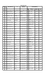
Barguna at a Glance.pdf - Bbs.gov.bd
Barguna at a Glance.pdf - Bbs.gov.bd
Barguna at a Glance.pdf - Bbs.gov.bd

Create successful ePaper yourself
Turn your PDF publications into a flip-book with our unique Google optimized e-Paper software.
Community Report<br />
<strong>Barguna</strong> Zila<br />
June 2012<br />
Popul<strong>at</strong>ion and Housing Census 2011<br />
Bangladesh Bureau of St<strong>at</strong>istics<br />
St<strong>at</strong>istics and Inform<strong>at</strong>ics Division<br />
Ministry of Planning
EDITORIAL COMMITTEE<br />
Chairman<br />
Riti Ibrahim<br />
Secretary<br />
St<strong>at</strong>istics and Inform<strong>at</strong>ics Division<br />
Ministry of Planning<br />
Vice-Chairman<br />
Golam Mostafa Kamal<br />
Director General<br />
Bangladesh Bureau of St<strong>at</strong>istics<br />
Members<br />
Md. Mizanur Rahman Deputy Director General<br />
Md. Mostafizur Rahman Director<br />
Salima Sultana Director<br />
A<strong>bd</strong>ullah Harun Pasha Director<br />
Aziza Parvin Director<br />
S<strong>at</strong>ya Ranjan Mondal Director<br />
Md. Shamsul Alam Director (C.C)<br />
Member-Secretary<br />
Ashim Kumar Dey Director (Deputy Secretary) and Project Director
BANGLADESH POPULATION AND<br />
HOUSING CENSUS 2011<br />
COMMUNITY REPORT<br />
ZILA: BARGUNA<br />
June 2012<br />
POPULATION AND HOUSING CENSUS 2011<br />
BANGLADESH BUREAU OF STATISTICS<br />
STATISTICS AND INFORMATICS DIVISION<br />
MINISTRY OF PLANNING<br />
GOVERNMENT OF THE PEOPLE’S REPUBLIC OF<br />
BANGLADESH<br />
COMPLIMENTARY
Foreword<br />
Preface<br />
Zila map and Geo-code<br />
Zila <strong>at</strong> a glance<br />
Chapter-1: Introduction<br />
Chapter-2: Concepts and Definitions<br />
Chapter-3: About the Zila/Upazila<br />
Chapter-4: COMMUNITY TABLES<br />
CONTENTS<br />
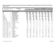
Table C01 : Area, Households, Popul<strong>at</strong>ion, Density by Residence and Community<br />
Table C02: Distribution of Households and Popul<strong>at</strong>ion by Sex, Sex R<strong>at</strong>io, Residence and<br />
Community<br />
Table C03 : Percentage Distribution of General Households by Size, Average size, Residence and<br />
Community<br />
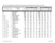
Table C04 : Percentage Distribution of Popul<strong>at</strong>ion by Age groups, Residence and Community<br />
Table C05 : Percentage Distribution of Popul<strong>at</strong>ion aged 10 years and above by Sex, Marital st<strong>at</strong>us,<br />
Residence and Community<br />
Table C06 : Distribution of Popul<strong>at</strong>ion aged 7 years and above by Literacy, Sex, Residence and<br />
Community<br />
Table C07 : Distribution of Popul<strong>at</strong>ion aged 3-14 years by Age groups, School <strong>at</strong>tendance, Sex,<br />
Residence and Community<br />
Table C08 : Distribution of Popul<strong>at</strong>ion aged 15-29 years by Age groups, School <strong>at</strong>tendance , Sex,<br />
Residence and Community<br />
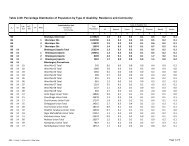
Table C09 : Percentage Distribution of Popul<strong>at</strong>ion by Type of disability, Residence and Community<br />
Table C10: Distribution of Popul<strong>at</strong>ion aged 7 years and above not <strong>at</strong>tending school by Employment<br />
st<strong>at</strong>us, Sex, Residence and Community<br />
Table C11: Distribution of Popul<strong>at</strong>ion aged 7 years and above not <strong>at</strong>tending school but employed<br />
by Field of activity, Sex, Residence and Community<br />
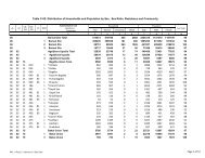
Table C12 : Distribution of Ethnic Household, Popul<strong>at</strong>ion by Sex, Residence and Community<br />
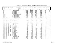
Table C13: Distribution of Popul<strong>at</strong>ion by Religion, Residence and Community<br />
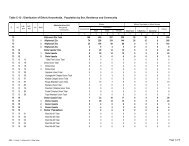
Table C14: Percentage Distribution of General Households by Type of structure, Toilet facility,<br />
Residence and Community<br />
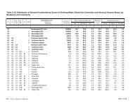
Table C15: Distribution of General Households by Source of drinking w<strong>at</strong>er, Electricity connection<br />
and Housing tenancy st<strong>at</strong>us by Residence and Community<br />
APPENDICES<br />
Appendix-I List of Personnel Engaged in Preparing this Report<br />
Appendix-II Census Questionnaire
Foreword<br />
The fifth popul<strong>at</strong>ion census was conducted over a period of five days starting <strong>at</strong> the zero hour of<br />
15 March 2011 and completed on the 19 March 2011. Popul<strong>at</strong>ion census indeed is the only<br />
recognized source in Bangladesh for quality benchmark d<strong>at</strong>abase pertaining to popul<strong>at</strong>ion size<br />
and its sp<strong>at</strong>ial distribution and for various basic demographic characteristics. Along with n<strong>at</strong>ional<br />
level aggreg<strong>at</strong>es, the census has gener<strong>at</strong>ed detailed segreg<strong>at</strong>ed d<strong>at</strong>a <strong>at</strong> community levels<br />
(mahallas/mauzas/villages) of the country being a full-count st<strong>at</strong>istical undertaking. The initi<strong>at</strong>ive of<br />
publishing zila community reports has been undertaken considering the importance of community<br />
level d<strong>at</strong>a and inform<strong>at</strong>ion apart from n<strong>at</strong>ional level in the process of determining policy-str<strong>at</strong>egy<br />
and decision-making.The <strong>Barguna</strong> zila community report is one of those 64 “Community Reports”<br />
<strong>at</strong> zila level.<br />
The census results “<strong>at</strong> a glance” table for each upazila of <strong>Barguna</strong> zila have been presented in<br />
this report. Tables containing various st<strong>at</strong>istics separ<strong>at</strong>ely by mahallas, mauzas and villages are<br />
incorpor<strong>at</strong>ed for readers' convenience. I believe th<strong>at</strong> the wide array of census findings presented in<br />
this zila community report will be useful to planners and policy makers in formul<strong>at</strong>ing,<br />
implementing and evalu<strong>at</strong>ing responsive development plans and programmes for human resource<br />
advancement and overall development. In addition, the census d<strong>at</strong>a and inform<strong>at</strong>ion of this report<br />
will be helpful for researchers both <strong>at</strong> home and abroad.<br />
Census is a massive oper<strong>at</strong>ion. Its success depends on devoted endeavor of census workers and<br />
also on particip<strong>at</strong>ion of people <strong>at</strong> all levels. We gr<strong>at</strong>efully acknowledge the active particip<strong>at</strong>ion of all<br />
<strong>gov</strong>ernment and priv<strong>at</strong>e agencies, zila administr<strong>at</strong>ions, local <strong>gov</strong>ernments <strong>at</strong> various levels<br />
including Union Parisads, Upazila Parishads, Paurashavas, Media Groups of the country. Their<br />
contribution and all-out support towards making the census a success will always be highly<br />
appreci<strong>at</strong>ed. I express my gr<strong>at</strong>itude to the United N<strong>at</strong>ions Popul<strong>at</strong>ion Fund (UNFPA), European<br />
Union (EU), US Census Bureau and USAID for their financial and technical supports for<br />
completing this huge task. I am gr<strong>at</strong>eful to the Cabinet Secretary and the Secretary, Ministry of<br />
Public Administr<strong>at</strong>ion for their active cooper<strong>at</strong>ion. I express my gr<strong>at</strong>itude to the Honorable Minister,<br />
Ministry of Planning for his proper guidance and active cooper<strong>at</strong>ion in making this census a<br />
success.<br />
ICR (Intelligent Character Recognition) machines and iCADE (Integr<strong>at</strong>ed Computer Assisted D<strong>at</strong>a<br />
Entry) system were used in capturing the census d<strong>at</strong>a. CSPro software was used in analyzing and<br />
processing of d<strong>at</strong>a. It took almost six years to publish the final report of Popul<strong>at</strong>ion and Housing<br />
Census 2001 and four years for 1991 Census following the enumer<strong>at</strong>ion. For Popul<strong>at</strong>ion and<br />
Housing Census 2011, we had reduced the gap by publishing all reports including community and<br />
zila reports within the shortest possible time. This is the first time in the census history of<br />
Bangladesh th<strong>at</strong> the census reports are being published within 15 months after the enumer<strong>at</strong>ion. I<br />
express my thanks to the Director General, BBS, Project Director, Mr. Ashim Kumar Dey and all<br />
those involved in the effort to finally bring the report out within the shortest time.<br />
Dhaka ( Riti Ibrahim )<br />
Ashar, 1419<br />
June, 2012<br />
Secretary<br />
St<strong>at</strong>istics and Inform<strong>at</strong>ics Division<br />
Ministry of Planning<br />
Government of the People’s<br />
Republic of Bangladesh
Preface<br />
Bangladesh inherited the tradition of conducting the popul<strong>at</strong>ion census on decennial basis since<br />
1872. The fifth popul<strong>at</strong>ion census of Bangladesh and fifteenth in the region, sequencing the<br />
decennial periodicity, was conducted during March 15-19, 2011. The main objective of the census<br />
was to collect inform<strong>at</strong>ion on the basic characteristics rel<strong>at</strong>ed to housing, households and<br />
popul<strong>at</strong>ion for developing a comprehensive d<strong>at</strong>abase for all development planning and human<br />
resource development programmes as well as economic management.<br />
As per decisions of the N<strong>at</strong>ional St<strong>at</strong>istical Council (NSC), Popul<strong>at</strong>ion and Housing Census had<br />
been conducted in three phases. In phase I, basic d<strong>at</strong>a about all households and individual<br />
members of the households were g<strong>at</strong>hered through using ICR form<strong>at</strong>ted questionnaire during<br />
March 15-19, 2011. In phase II, quality and coverage of the main count were verified through a<br />
Post Enumer<strong>at</strong>ion Check (PEC) survey during April 10-14, 2011. For the first time in census<br />
history of Bangladesh, the PEC was conducted by an independent organiz<strong>at</strong>ion,<br />
Bangladesh Institute of Development Studies (BIDS). In phase III, detailed socio-economic<br />
inform<strong>at</strong>ion was collected by adopting a long machine readable questionnaire in a sample survey<br />
held during October 15-25, 2011.<br />
Bangladesh Bureau of St<strong>at</strong>istics (BBS) started the census prepar<strong>at</strong>ory activity from mid 2009 with<br />
the upd<strong>at</strong>ing of maps and area Geo-codes. Several preliminary checks of the questionnaire were<br />
made locally. The census questionnaire was pre-tested in selected areas with particip<strong>at</strong>ion of<br />
some experts of the “Technical Committee”. Users’ and experts’ views were taken to finalize the<br />
questionnaire. The census field oper<strong>at</strong>ion and quality of census inputs were tested by two Zonal<br />
oper<strong>at</strong>ions. Accordingly the questionnaire was designed in machine readable form<strong>at</strong> with<br />
the technical assistance from US Census Bureau and was printed abroad with the<br />
financial assistance from European Union (EU) through the United N<strong>at</strong>ions Popul<strong>at</strong>ion<br />
Fund (UNFPA).<br />
To ensure coverage, effective management and close supervision, the entire country was divided<br />
into 2,96,718 enumer<strong>at</strong>ion areas (EAs) by using enumer<strong>at</strong>ion maps. For every group of 6/7<br />
enumer<strong>at</strong>ors there was one supervisor. The geo-coding system developed in the previous<br />
censuses was checked, upd<strong>at</strong>ed and computerized.<br />
Modified Defacto Method was adopted in counting the popul<strong>at</strong>ion. Zero hour of the night of 15<br />
March, 2011 was considered as the census moment. On the other hand, the hours between<br />
census moment and the following morning (6.00 a.m.) i.e. morning of 15 March, 2011 was reconed<br />
as the census night. To avoid omission and duplic<strong>at</strong>ion, people were counted where they were<br />
found in the census night.<br />
For oper<strong>at</strong>ional convenience all the available officers and staff members of BBS and other<br />
organiz<strong>at</strong>ion were mobilized as follows:<br />
Functional Design<strong>at</strong>ion Design<strong>at</strong>ion Number<br />
Chief Census Coordin<strong>at</strong>or Secretary, St<strong>at</strong>istics and Inform<strong>at</strong>ics Division 1<br />
N<strong>at</strong>ional Census Coordin<strong>at</strong>or Director General, BBS 1<br />
Deputy N<strong>at</strong>ional Census<br />
Coordin<strong>at</strong>or<br />
Joint Secretary/Deputy Director General 2<br />
Census Zila Coordin<strong>at</strong>or Director/Deputy Secretary/Joint Director/Deputy<br />
Director/St<strong>at</strong>istical Officer<br />
130<br />
Upazila Census Coordin<strong>at</strong>or Upazila St<strong>at</strong>istical Officer/Assistant St<strong>at</strong>istical 530<br />
Officer<br />
Zonal Officer USO/ASO/TS/SI/SA/JSA/Officials from other<br />
Departments<br />
2612
For actual enumer<strong>at</strong>ion 2,96,718 enumer<strong>at</strong>ors and 48,531 supervisors were employed from<br />
among the local educ<strong>at</strong>ed unemployed persons of them 50% were females.<br />
A verb<strong>at</strong>im training manual was prepared and used for imparting uniform training to all the census<br />
workers. Audio-Visual training was imparted for the trainees for making uniformity all over the<br />
country. Training was given <strong>at</strong> three levels:<br />
(i) Training of Master Trainers (Census Zila Coordin<strong>at</strong>ors) <strong>at</strong> Dhaka;<br />
(ii) Training of Zonal Officers <strong>at</strong> Zila levels and<br />
(iii) Training of Supervisors and Enumer<strong>at</strong>ors <strong>at</strong> the local levels.<br />
A calendar of census activities was developed and was adhered to strictly in providing training,<br />
distribution of census m<strong>at</strong>erials, doing actual enumer<strong>at</strong>ion and returning all filled in questionnaire<br />
to Dhaka head office census control room.<br />
A Centralized Processing System was developed constituting the census analysis and report<br />
writing team. Under the system, Computer editing, D<strong>at</strong>a capture by ICR/iCADE and tabul<strong>at</strong>ion<br />
through CSPro software were system<strong>at</strong>ically linked.<br />
For ensuring particip<strong>at</strong>ion of local administr<strong>at</strong>ion and local bodies in census work census<br />
committees were formed <strong>at</strong> the Zila, Upazila, Paurashava and Union/Ward levels. In addition,<br />
Enumer<strong>at</strong>ors and Supervisors were appointed from amongst the local educ<strong>at</strong>ed unemployed<br />
youths.<br />
A Standing Technical Committee comprising of well-known local census experts and users of<br />
census d<strong>at</strong>a was formed <strong>at</strong> n<strong>at</strong>ional level to provide technical support to BBS in planning,<br />
designing and executing the census. A seminar-cum-expert consult<strong>at</strong>ion was held <strong>at</strong> BBS with the<br />
census d<strong>at</strong>a users, experts, researchers and educ<strong>at</strong>ionist to get their views on finaliz<strong>at</strong>ion of<br />
census questionnaire and policy rel<strong>at</strong>ed issues.<br />
For cre<strong>at</strong>ing public awareness and motiv<strong>at</strong>ion a n<strong>at</strong>ion wide publicity campaign was carried out<br />
before the census through posters, banners, leaflets, brochures, fe<strong>at</strong>ures film, zingle, miking,<br />
radio, television, mobile message and newspaper.<br />
I express my deepest gr<strong>at</strong>itude to Secretary, St<strong>at</strong>istics and Inform<strong>at</strong>ics Division for her<br />
wholehearted support and cooper<strong>at</strong>ion to the census.<br />
I express my deep gr<strong>at</strong>itude to all Standing Technical Committee members and also to all<br />
participants of the Seminar-cum-Expert Consult<strong>at</strong>ion for their valuable contributions towards<br />
finalizing the questionnaire and the census programme.<br />
I am thankful to all members of the sub-committees on publicity, sampling and report writing for<br />
their valuable contribution. I am also thankful to our mass media, local bodies and the people of all<br />
level for their wholehearted supports to the census.<br />
Finally, I thank the Project Director Mr. Ashim Kumar Dey and other officers and staff members of<br />
Bangladesh Bureau of St<strong>at</strong>istics for their untiring efforts in making the census a success within a<br />
very short period of time and in public<strong>at</strong>ion of this report.<br />
Dhaka ( Golam Mostafa Kamal )<br />
Ashar, 1419 Director General<br />
June, 2012 Bangladesh Bureau of St<strong>at</strong>istics
Map of <strong>Barguna</strong> Zila
04 - <strong>Barguna</strong> Zila<br />
Upazila and Union/Ward with Geo-code 2011<br />
09-Amtali Upazila 28-<strong>Barguna</strong> Sadar Upazila Betagi Paurashava<br />
13-Amtali Union 17-Aylap<strong>at</strong>ak<strong>at</strong>a Union 01-Ward-01<br />
15-Arpangashia Union 19-Badarkhali Union 02-Ward-02<br />
23-Atharagasia Union 28-<strong>Barguna</strong> Union 03-Ward-03<br />
39-Barabagi Union 38-Burirchar Union 04-Ward-04<br />
43-Chhotabagi Union 47-Dhalua Union<br />
47-Chowra Union 57-Phuljhury Union 05-Ward-05<br />
63-Gulishakhali Union 66-Gaurichana Union 06-Ward-06<br />
71-Haldia Union 76-Keorabunia Union 07-Ward-07<br />
79-Karaibaria Union 85-M.Bali<strong>at</strong>ali Union 08-Ward-08<br />
87-Kukua Union 95-Naltona Union 09-Ward-09<br />
91-Nishanbaria Union<br />
94-Panchakoralia Union <strong>Barguna</strong> Paurashava 85-P<strong>at</strong>hargh<strong>at</strong>a Upazila<br />
95-Sarikhali Union 01-Ward-01 11-Char Duani Union<br />
96-Sonak<strong>at</strong>a Union 02-Ward-02 23-Kakchira Union<br />
03-Ward-03 35-Kalmegha Union<br />
Amtali Paurashava 04-Ward-04 47-K<strong>at</strong>haltali Union<br />
01-Ward-01 05-Ward-05 59-Nachnapara Union<br />
02-Ward-02 06-Ward-06 71-P<strong>at</strong>hargh<strong>at</strong>a Union<br />
03-Ward-03 07-Ward-07 83- Raihanpur Union<br />
04-Ward-04 08-Ward-08<br />
05-Ward-05 09-Ward-09 P<strong>at</strong>hargh<strong>at</strong>a Paurashava<br />
06-Ward-06 01-Ward-01<br />
07-Ward-07 47-Betagi Upazila 02-Ward-02<br />
08-Ward-08 11-Betagi Union 03-Ward-03<br />
09-Ward-09 23-Bibichini Union 04-Ward-04<br />
35-Buramazumdar Union 05-Ward-05<br />
19-Bamna Upazila 47-Hosnabad Union 06-Ward-06<br />
23-Bamna Union 59-Kazirabad Union 07-Ward-07<br />
47-Bukabunia Union 71-Mokamia Union 08-Ward-08<br />
71-Dau<strong>at</strong>ala Union 83-Sarishamuri Union 09-Ward-09<br />
95-Ramna Union
Main Census Results <strong>at</strong> N<strong>at</strong>ional, Division and Zila Levels<br />
Items<br />
Popul<strong>at</strong>ion (Enumer<strong>at</strong>ed)<br />
Bangladesh Barisal Division<br />
<strong>Barguna</strong> Zila<br />
2011 2001<br />
Both Sex 14,40,43,697 83,25,666 8,92,781 8,48,554<br />
Male 7,21,09,796 40,89,508 4,37,413 4,30,322<br />
Female 7,19,33,901 42,36,158 4,55,368 4,18,232<br />
Urban 2,74,68,789 9,48,844 76,927 62,902<br />
Other Urban 60,94,394 4,13,099 26,167 24,680<br />
Rural 11,04,80,514 69,63,723 7,89,687 7,60,972<br />
Annual growth r<strong>at</strong>e<br />
Sex R<strong>at</strong>io<br />
1.47 0.18 0.5 0.90<br />
Total 100 97 96 103<br />
Urban 110 104 104 118<br />
Other Urban 105 98 98 104<br />
Rural<br />
Households (HH)<br />
98 95 95 102<br />
Total 3,21,73,630 18,62,841 2,15,842 1,79,968<br />
Urban 61,33,012 2,10,298 18,403 13,554<br />
Other Urban 13,69,028 91,240 6,379 5,315<br />
Rural<br />
Average HH Size<br />
2,46,71,590 15,61,303 1,91,060 1,61,099<br />
Total 4.44 4.45 4.12 4.72<br />
Urban 4.36 4.39 4.11 4.66<br />
Other Urban 4.42 4.49 4.10 4.63<br />
Rural 4.46 4.45 4.12 4.73<br />
Area sq. km 147569.06 13225.20 1831.31 1831.31<br />
Area sq. mile 56976.00 5106.00 707.07 707.07<br />
Density per sq. km 976 630 488 463<br />
Density per sq. mile 2528 1630 1263 1200<br />
Urbaniz<strong>at</strong>ion (%)<br />
Literacy (%)<br />
23.30 16.36 11.55 10.32<br />
Both Sex 51.8 56.8 57.6 55.3<br />
Male 54.1 57.6 59.2 57.7<br />
Female<br />
School Attendance (5 to 24 years) (%)<br />
49.4 55.9 56.1 52.8<br />
Both Sex 52.7 57.0 59.1 45.9<br />
Male 54.6 59.1 62.7 48.8<br />
Female<br />
Popul<strong>at</strong>ion(Adjusted)<br />
50.8 55.0 55.7 42.9<br />
Both Sex 14,97,72,364 86,52,324 9,27,890 8,87,678<br />
Male 7,49,80,386 42,50,113 4,54,636 4,50,189<br />
Female<br />
Geographic Unit<br />
7,47,91,978 44,02,211 4,73,254 4,37,489<br />
Upazila/Thana 545 40 5 5<br />
Union 4,562 349 42 38<br />
Mauza 54,327 2,920 259 257<br />
Village 87,191 4,097 562 560<br />
City Corpor<strong>at</strong>ion 6 1 0 0<br />
City Ward 283 30 0 0<br />
City Mahalla 1,909 401 0 0<br />
Paurashava 310 24 4 4<br />
Paura Ward 2,914 216 36 36<br />
Paura Mahalla 8,667 401 50 51
CHAPTER – 1<br />
Introduction<br />
The popul<strong>at</strong>ion and housing census is the unique source of reliable and comprehensive<br />
d<strong>at</strong>a about the size of the popul<strong>at</strong>ion of the country, major socio-economic and socio-demographic<br />
characteristics.<br />
It is the total process of collecting, compiling, evalu<strong>at</strong>ing, analyzing and publishing or otherwise<br />
dissemin<strong>at</strong>ing demographic, economic and social d<strong>at</strong>a pertaining, <strong>at</strong> a specified time, to all<br />
persons in a country. The essential fe<strong>at</strong>ures of a popul<strong>at</strong>ion census are individual enumer<strong>at</strong>ion,<br />
universality within a defined territory, simultaneity and defined periodicity.<br />
The popul<strong>at</strong>ion and housing census provides inform<strong>at</strong>ion on the geographic and<br />
administr<strong>at</strong>ive distribution of the popul<strong>at</strong>ion and household in addition to the demographic and<br />
socioeconomic characteristics of all the people in the country. The d<strong>at</strong>a from the census are<br />
classified, tabul<strong>at</strong>ed and dissemin<strong>at</strong>ed so th<strong>at</strong> political leaders, election officials, planners, n<strong>at</strong>ional<br />
organiz<strong>at</strong>ions including NGOs and civil society, regional and intern<strong>at</strong>ional organiz<strong>at</strong>ions can use<br />
the d<strong>at</strong>a in decision-making.<br />
The purpose of community report is to dissemin<strong>at</strong>e census d<strong>at</strong>a by communities<br />
(ward/mahalla in urban area and union/mauza/village in rural area). D<strong>at</strong>a on all key variables<br />
namely area, household, popul<strong>at</strong>ion by sex and age group, ethnic popul<strong>at</strong>ion, literacy r<strong>at</strong>e, marital<br />
st<strong>at</strong>us, school <strong>at</strong>tendance , employment st<strong>at</strong>us and religion as well as physical facilities such as<br />
source of drinking w<strong>at</strong>er, sanit<strong>at</strong>ion, electricity and dwelling units have been presented in this<br />
report. The planners, researchers and policy makers as well as development partners and<br />
community administr<strong>at</strong>ors will find this report as a valuable reference for use in advising plans and<br />
programs for advancing welfare and well-being of the common people, in particular and the<br />
community in general.<br />
Census and its Periodicity<br />
Bangladesh Bureau of St<strong>at</strong>istics is in charge of conducting the Popul<strong>at</strong>ion and Housing<br />
Census. The practice of census taking in the area, now Bangladesh, started in 1872. Thereafter,<br />
another census was conducted in 1881 and from then on the decennial periodicity of census was<br />
maintained with the exception of 1971 cycle which was held up and delayed till the year 1974<br />
because of liber<strong>at</strong>ion war. The 1974 census was the first census in Bangladesh after her<br />
emergence as a new independent n<strong>at</strong>ion in 1971. Bangladesh went back to the decennial<br />
periodicity and held the second, third, and fourth censuses in the years 1981, 1991 and 2001. The<br />
2011 census is the 5 th after independence of Bangladesh.<br />
Objectives: The popul<strong>at</strong>ion census was carried out to achieve the following objectives:<br />
► To determine the popul<strong>at</strong>ion and the number of households of the country;<br />
► To obtain d<strong>at</strong>a on demographic characteristics by gender;<br />
► To obtain d<strong>at</strong>a on disability;<br />
► To collect inform<strong>at</strong>ion on housing, household structure and other selected facilities;<br />
►To gener<strong>at</strong>e d<strong>at</strong>a on gender specific occup<strong>at</strong>ion and particip<strong>at</strong>ion in economic activities;<br />
►To g<strong>at</strong>her basic inform<strong>at</strong>ion on ethnic people and<br />
► To prepare socio-economic d<strong>at</strong>abase for policy makers, planners and researchers etc.<br />
Census Phasing: The census d<strong>at</strong>a collection was completed in three phases.<br />
Phase I - Main Count: Collection of basic inform<strong>at</strong>ion for all households and individuals<br />
using an ICR form<strong>at</strong>ted Questionnaire.
Phase II- Post Enumer<strong>at</strong>ion Check (PEC): A PEC survey was carried out to measure<br />
quality and coverage of the main census count. The survey was conducted immedi<strong>at</strong>ely after<br />
receiving filled-in census questionnaires in Dhaka head office. For the first time in census history<br />
of Bangladesh, the PEC was conducted by an independent organiz<strong>at</strong>ion, Bangladesh Institute of<br />
Development Studies (BIDS).<br />
Phase III- Sample Census: A sample census (large scale sample survey) was carried<br />
out <strong>at</strong> the last phase. For this undertaking, ICR form<strong>at</strong>ted long questionnaire was adopted to<br />
supplement the d<strong>at</strong>a of the main census. Being a programme of much wider inform<strong>at</strong>ion coverage,<br />
the sample census provided detailed d<strong>at</strong>a rel<strong>at</strong>ing to popul<strong>at</strong>ion and household characteristics<br />
including fertility, mortality, morbidity, migr<strong>at</strong>ion etc.<br />
Census Oper<strong>at</strong>ion<br />
Census Planning: The census prepar<strong>at</strong>ory work programme was mounted in mid 2009. A<br />
census work-plan was prepared defining in details the activities to be performed and completed by<br />
specific d<strong>at</strong>es in each calendar year. Field instruction manual and training manual were produced<br />
for census workers of different stages. These manuals provided precise guidelines regarding: (i)<br />
duties and responsibilities to be performed <strong>at</strong> all levels, (ii) lessons to be given when imparting<br />
trainings to field supervisors and enumer<strong>at</strong>ors, (iii) mapping and geo-coding oper<strong>at</strong>ion to be done,<br />
(iv) questionnaire to be filled-up, (v) enumer<strong>at</strong>ion and supervision disciplines to be adhered to, (vi)<br />
census workers to be put in place (vii) census m<strong>at</strong>erials to be distributed and (viii) publicity plan to<br />
be implemented.<br />
Mapping<br />
The upd<strong>at</strong>ed and well furnished map is one of the basic instruments to the success of any<br />
popul<strong>at</strong>ion and housing census. The primary objectives of the mapping oper<strong>at</strong>ion is (i) to upd<strong>at</strong>e<br />
the produced GIS maps and deline<strong>at</strong>e enumer<strong>at</strong>ion areas (EA) in the country to facilit<strong>at</strong>e the<br />
smooth counting of inhabitants during enumer<strong>at</strong>ion and (ii) fundamentally to ascertain th<strong>at</strong> all<br />
areas are covered and th<strong>at</strong> everyone in the country is counted with minimal possibility of under or<br />
over counting.<br />
Household counting for EA demarc<strong>at</strong>ion and concurrent EA mapping activities were carried<br />
out in two phases beginning from May, 2009. The First phase, confined to exclusively rural areas,<br />
necessit<strong>at</strong>ed upd<strong>at</strong>ing and preparing union, mauza, and control maps. The second phase was<br />
initi<strong>at</strong>ed only for urban coverage in view of the complex task associ<strong>at</strong>ed with household and EA<br />
boundary identific<strong>at</strong>ions due to quite dense habit<strong>at</strong>ions in urban localities. All urban ward, mahalla,<br />
and control maps were upd<strong>at</strong>ed and/or newly prepared showing current boundaries. BBS used<br />
GIS Maps for field oper<strong>at</strong>ion for the first time in census history of Bangladesh. GIS Maps Project of<br />
BBS produced the maps from aerial photography. The upd<strong>at</strong>ed maps were used for zonal<br />
oper<strong>at</strong>ions. All maps were finally checked and upd<strong>at</strong>ed during zonal oper<strong>at</strong>ions. The upd<strong>at</strong>ed EA<br />
maps were used for main census, PEC and sample census.<br />
Designing and Pre-testing of Questionnaire: The contents of census questionnaire were<br />
determined based on d<strong>at</strong>a needs assessed on <strong>gov</strong>ernment current priorities and also<br />
recommend<strong>at</strong>ions of technical committee experts. Several preliminary checks of the questionnaire<br />
were made locally. Lastly, the questionnaire was pre-tested in selected areas with particip<strong>at</strong>ion of<br />
some experts of the technical committee. S<strong>at</strong>isfactory pre-test results were resolved finalising a<br />
two moduled questionnaire for adoption in the census. Accordingly the questionnaire was<br />
designed in machine readable form<strong>at</strong> with the technical assistance from US Census Bureau and<br />
was printed abroad with the financial assistance from European Union (EU) through United<br />
N<strong>at</strong>ions Popul<strong>at</strong>ion Fund (UNFPA).<br />
Questionnaire: A two moduled questionnaire was used for the main census. As many as 25<br />
questions were included in it. Of them 11 questions rel<strong>at</strong>ing to housing and household<br />
characteristics were covered in household module. The remaining 14 questions focusing on<br />
household individuals were incorpor<strong>at</strong>ed in individual module. The questionnaire items were
identific<strong>at</strong>ion, address of household, number and structure of house including tenancy, toilet<br />
facility, access to electricity, ethnicity, individual age, sex, religion, marital st<strong>at</strong>us, literacy,<br />
disability, educ<strong>at</strong>ion and working st<strong>at</strong>us. All d<strong>at</strong>a on the items were collected through visiting house<br />
to house and interviewing head of the household or responsible member in absence of head of the<br />
household.<br />
Zonal Oper<strong>at</strong>ion: Two zonal oper<strong>at</strong>ions were executed in both urban and rural areas. These<br />
oper<strong>at</strong>ions allowed setting up a system germane to: (i) involve local people in the census, (ii)<br />
interact with local bodies, and (iii) ensure efficient field work arrangements.<br />
The first zonal oper<strong>at</strong>ion was held during May-July 2010 in 3 (three) phases. In first phase<br />
it covered 39 zilas, second phase 17 zilas and third phase 8 zilas. During first zonal oper<strong>at</strong>ion the<br />
following tasks were completed:<br />
a) Upd<strong>at</strong>ing geo-code list;<br />
b) Upd<strong>at</strong>ing Mauza and Mahalla maps with demarc<strong>at</strong>ion of EA boundaries;<br />
c) Preparing Supervisor sketch maps;<br />
d) Preparing primary list of local enumer<strong>at</strong>ors and supervisors with names and<br />
addresses and<br />
e) Identifying depopul<strong>at</strong>ed Mauzas and Mahallas<br />
Besides, Zonal Officers introduced themselves to the public represent<strong>at</strong>ives of different bodies and<br />
local administr<strong>at</strong>ion and sought their support and cooper<strong>at</strong>ion in completing census activities<br />
successfully.<br />
The second zonal oper<strong>at</strong>ion was mounted just three months prior, i.e. November-<br />
December 2010, to conduct the main census in March, 2011. This schedule ensured the smooth<br />
flow of census activities including field management system.<br />
The second zonal oper<strong>at</strong>ion fe<strong>at</strong>ured completing tasks such as:<br />
(a) instituting census committees in zilas, upazilas/Thanas, wards/unions, paurashavas<br />
and city corpor<strong>at</strong>ions,<br />
(b) interacting with local bodies,<br />
(c) verifying supervisor maps and getting those finalised,<br />
(d) finalising the lists of supervisors and enumer<strong>at</strong>ors and<br />
(e) checking and endorsing loc<strong>at</strong>ions and available facilities of training centres selected to<br />
train enumer<strong>at</strong>ors and supervisors. All these activities were performed by 2,612 Zonal Officers<br />
under supervision of 130 Census Zila Coordin<strong>at</strong>ors who were engaged from BBS and other<br />
ministries.<br />
In forming EAs, the terrains and habit<strong>at</strong>ion p<strong>at</strong>terns of localities were taken into<br />
consider<strong>at</strong>ion. Mauza/Ward maps were used for exact identific<strong>at</strong>ions of EAs within mauzas and<br />
wards. During census enumer<strong>at</strong>ion final base maps and supervisor maps were used by the zonal<br />
officers, enumer<strong>at</strong>ors and supervisors for field control and overcoming coverage errors.<br />
Organiz<strong>at</strong>ion: The lowest unit of census was enumer<strong>at</strong>ion area (EA). All over the country as<br />
many as 2,96,718 EAs were deline<strong>at</strong>ed. Above them there were 48,531 supervisors’ areas (SAs)<br />
with every SA having 6-7 EAs. For each EA one enumer<strong>at</strong>or and each SA one supervisor were<br />
appointed temporarily from amongst local educ<strong>at</strong>ed youths. Females were given priority in<br />
selecting enumer<strong>at</strong>ors and supervisors. Enumer<strong>at</strong>ors and supervisors were controlled by 2,612<br />
Zonal Officers. Immedi<strong>at</strong>ely above zonal officers there were 130 Census Zila Co-coordin<strong>at</strong>ors<br />
deployed from Class-I officers of BBS and other ministries. The Project Director of Popul<strong>at</strong>ion and<br />
Housing Census Project was the co-ordin<strong>at</strong>or of field activities and maintained liaison with higher<br />
authority and different organis<strong>at</strong>ions. The Director General of Bangladesh Bureau of St<strong>at</strong>istics<br />
acted as the N<strong>at</strong>ional Coordin<strong>at</strong>or. The Secretary of St<strong>at</strong>istics and Inform<strong>at</strong>ics Division was the<br />
Chief Census Coordin<strong>at</strong>or who guided the whole system of census programme and<br />
implement<strong>at</strong>ion.<br />
The local administr<strong>at</strong>ion and public represent<strong>at</strong>ives particip<strong>at</strong>ed in the census through<br />
census committees formed for City Corpor<strong>at</strong>ions, Paurashavas, Zilas, Upazilas, Wards, and Union<br />
Parisads. The Mayors of City Corpor<strong>at</strong>ions and Paurashavas, Deputy Commissioners, Upazila<br />
Chairmen, Ward Commissioners and Chairmen of Union Parishads headed respective census<br />
committees with BBS officials being the Member-Secretaries.
Central census control room was established <strong>at</strong> Dhaka headquarters of BBS<br />
(Parishankhan Bhaban) under active supervision of the Project Director. Similarly control rooms<br />
were established in each spheres of administr<strong>at</strong>ive levels namely zila, upazila and union. These<br />
control rooms functioned round the clock during entire field enumer<strong>at</strong>ion period. A number of<br />
officials were engaged to provide logistics during census field activities, monitored constantly the<br />
census performance, informed the N<strong>at</strong>ional Coordin<strong>at</strong>or and Chief Census Co-ordin<strong>at</strong>or about<br />
performance st<strong>at</strong>us and obtained their instructions for successful completion of the census.<br />
Enumer<strong>at</strong>ion: The popul<strong>at</strong>ion across all over of the country was counted <strong>at</strong> a stretch in five days<br />
from 15-19 March 2011 using machine readable questionnaires. The counting began <strong>at</strong> zero hour<br />
of 15 March 2011. Flo<strong>at</strong>ing people were counted from zero-hour till 6.00 am (the hours called<br />
census night) <strong>at</strong> the places where they were detected passing the night. In case of households, on the<br />
other hand, all members were enumer<strong>at</strong>ed in their residences. The modified de-facto method was<br />
followed in counting, i.e. every person was counted <strong>at</strong> the place where he/she stayed in the census night<br />
except the people on board and on duty, counted <strong>at</strong> their residence.<br />
D<strong>at</strong>a Capturing/Processing: The adoption of Intelligence Character Recognition (ICR)<br />
str<strong>at</strong>egy was planned for census d<strong>at</strong>a capturing. As such, ICR machines were procured. BBS had<br />
g<strong>at</strong>hered experience in OMR and OCR techniques d<strong>at</strong>a capturing from earlier censuses of 1981,<br />
1991 and 2001. The ICR technology was introduced <strong>at</strong> this census in BBS. US Census Bureau<br />
supported BBS in using CapturePro and iCADE (Integr<strong>at</strong>ed Computer Assisted D<strong>at</strong>a Entry)<br />
system for d<strong>at</strong>a capturing. For analyzing and tabul<strong>at</strong>ing census d<strong>at</strong>a CSPro software was used.<br />
iCADE: Integr<strong>at</strong>ed Computer Assisted D<strong>at</strong>a Entry provides digital images of respondent<br />
questionnaires. D<strong>at</strong>a is processed through OMR, OCR, and KFI, quality assurance, and<br />
autom<strong>at</strong>ed detailed tracking of each step in the process.<br />
Steps:<br />
1. B<strong>at</strong>ching and B<strong>at</strong>ch Identific<strong>at</strong>ion: Completed Census Questionnaires are<br />
b<strong>at</strong>ched for processing. An identifying b<strong>at</strong>ch cover sheet is cre<strong>at</strong>ed. B<strong>at</strong>ch st<strong>at</strong>us<br />
numbers are kept in the d<strong>at</strong>abase along with other relevant metad<strong>at</strong>a.<br />
2. Scanning: Each page from the b<strong>at</strong>ched Census Questionnaires is scanned into a<br />
TIFF Image. In each step st<strong>at</strong>us info is kept in the d<strong>at</strong>abase.<br />
3. Autoregistr<strong>at</strong>ion: Autoregistr<strong>at</strong>ion rel<strong>at</strong>es images to the Master Templ<strong>at</strong>e, registers<br />
Form barcodes, and reads checkboxes. There may be preliminary “mini” OCR<br />
processing here. Autoregistr<strong>at</strong>ion then cre<strong>at</strong>es a script with d<strong>at</strong>a captured so far.<br />
4. Manual Registr<strong>at</strong>ion: Images where auto-registr<strong>at</strong>ion detected positional tolerance<br />
errors are sent to a clerk, who resolves skewing and bar code issues and repairs<br />
checkbox ambiguities. The OMR clerk examines all checkboxes.<br />
5. B<strong>at</strong>ch Completeness/Exception Review: B<strong>at</strong>ch Completeness identifies b<strong>at</strong>ches<br />
with problems, forms with missing, loose, or duplic<strong>at</strong>e pages, b<strong>at</strong>ched not scanned,<br />
scanned not b<strong>at</strong>ched. In Exception Review, the clerk researches each issue (checking<br />
paper forms if needed) and takes appropri<strong>at</strong>e action.<br />
6. OCR Review: Converts design<strong>at</strong>ed handwritten and printed text fields to electronic<br />
d<strong>at</strong>a, with gre<strong>at</strong>er than 99% accuracy for numbers. A clerk then reviews OCR results,<br />
verifying all 1s, 2s, etc. Any rejected field must be reprocessed using KFI.<br />
7. Key From Image (KFI): The OMR portion of the program will capture check box d<strong>at</strong>a<br />
prior to KFI. KFI technology guides a keying clerk to the write-in fields on the form<br />
where the system detects presence. Furthermore, a keyer will not be taken to any fields<br />
already read by the OCR engine. Keyers may also re-register skewed pages or correct<br />
checkbox answers.<br />
8. Quality Assurance (QA): Two samples are drawn, one from the OCR read<br />
“universe” and one from the KFI keyed-in “universe”. They are sent to an independent<br />
keyer to be rekeyed. OCR and KFI may have different sampling r<strong>at</strong>es and different
accept/reject quality r<strong>at</strong>es. These results are then verified against the earlier captured<br />
d<strong>at</strong>a, and discrepancies are presented and corrected by analysts.<br />
9. Sample Verific<strong>at</strong>ion, Classific<strong>at</strong>ion and Adjudic<strong>at</strong>ion: A sample of the fields is<br />
keyed in by an independent verifier. A classifier reviews images and d<strong>at</strong>a from<br />
OCR/KFI and compares with verifier’s d<strong>at</strong>a. An adjudic<strong>at</strong>or determines final truth and<br />
decides if the b<strong>at</strong>ch is acceptable, and determines the cause of discrepancies, which<br />
may be charged against the original keyer.<br />
10. Remainder Verifier, Classifier and Adjudic<strong>at</strong>or: If b<strong>at</strong>ch quality for either<br />
universe is unacceptable, all remaining fields are rekeyed by a verifier, and results are<br />
compared and corrected by a classifier, and adjudic<strong>at</strong>ed by a final adjudic<strong>at</strong>or.<br />
All records were subject to an efficient computer edit and imput<strong>at</strong>ion programme. The errors and<br />
inconsistencies, if detected, were imputed by applying both 'hot-deck' and 'cold-deck' methods.<br />
For all zilas, separ<strong>at</strong>e files were maintained. The census tabul<strong>at</strong>ion plan was finalised through<br />
technical committee recommend<strong>at</strong>ions admitted of options for comparing most of the individual<br />
cells with 2001 census results. The tabul<strong>at</strong>ion programme was developed in CSPro and thoroughly<br />
tested before adopting for census tabul<strong>at</strong>ion. All tables gener<strong>at</strong>ed were transferred to MS<br />
Excel/MS Word form<strong>at</strong> for ensuring correct headings and footnotes.<br />
Public<strong>at</strong>ion: The census reports to be published will provide popul<strong>at</strong>ion inform<strong>at</strong>ion <strong>at</strong> the<br />
n<strong>at</strong>ional, zila and community levels. Besides the Community Reports, N<strong>at</strong>ional, Analytical, Zila<br />
Reports, Socio- economic & Demographic Report, Administr<strong>at</strong>ive Report and some Them<strong>at</strong>ic Area<br />
Reports will be published during the coming months.<br />
Post Enumer<strong>at</strong>ion Check (PEC): To assess coverage of the census an effectively designed<br />
Post Enumer<strong>at</strong>ion Check (PEC) survey was conducted just a month after completing the census.<br />
Bangladesh Institute of Development Studies (BIDS) conducted the PEC survey. The PEC survey<br />
d<strong>at</strong>a were collected during 10-14 April 2011. The net under coverage r<strong>at</strong>es estim<strong>at</strong>ed separ<strong>at</strong>ely<br />
for n<strong>at</strong>ional level aggreg<strong>at</strong>e and also for rural, urban, other urban (Upazila Headquarters) and City<br />
Corpor<strong>at</strong>ion areas are given below:<br />
Locality Net error r<strong>at</strong>e (%)<br />
N<strong>at</strong>ional<br />
Rural<br />
Urban<br />
Other Urban (UHQ)<br />
City Corpor<strong>at</strong>ion<br />
3.97<br />
3.80<br />
5.26<br />
4.07<br />
3.86<br />
The full PEC survey report can be obtained from Bangladesh Institute of Development Studies<br />
(BIDS) and the following online addresses of Bangladesh Bureau of St<strong>at</strong>istics and BIDS<br />
respectively:<br />
www.bbs.<strong>gov</strong>.<strong>bd</strong> and www.bids.org.<strong>bd</strong>
Chapter -2<br />
Concepts and Definitions:<br />
The concepts and definitions adopted for the census and those presented in this report are as<br />
follows:<br />
2.1 Census Moment<br />
It is the precise time hour fixed for starting up census enumer<strong>at</strong>ion n<strong>at</strong>ionwide. In the census the<br />
zero hour of 15 March 2011 was the census moment.<br />
2.2 Census Night<br />
The time span from census moment to 6:00 am of 15 March 2011 was the census night.<br />
2.3 Census Period<br />
It denotes the days devoted to complete the census enumer<strong>at</strong>ion activities. In this census 15-19<br />
March 2011 made up the census period.<br />
2.4 Reference period<br />
It is reference time cut off to which particular sets of census d<strong>at</strong>e items rel<strong>at</strong>e. In this census two<br />
reference periods were used. These are:<br />
i) Field of Economic Activity: One week preceding census moment (8 to 14 March<br />
2011)<br />
ii) For other variables: Census night.<br />
2.5 Modified De-facto Method<br />
It means the system of enumer<strong>at</strong>ing people <strong>at</strong> places of their stay in the census night. Adhering to<br />
this method the counting of flo<strong>at</strong>ing popul<strong>at</strong>ion across the country was completed during census<br />
night by interviewing them just <strong>at</strong> places of their night stay except the people on duty or on board.<br />
The remaining vast number of people found in usual residences were counted (including people<br />
on duty or on board) during 5 (five) days census period by fixing places of their stay during census<br />
night.<br />
2.6 Flo<strong>at</strong>ing Popul<strong>at</strong>ion<br />
People detected passing the census night <strong>at</strong> railway st<strong>at</strong>ions, launch gh<strong>at</strong>s, bus terminals, bo<strong>at</strong>s,<br />
temples, pagodas, mosques, hotels (boarders), footp<strong>at</strong>hs, under building-stairs,<br />
overpass/underpass and some other unusual places. Also the people who were fishing <strong>at</strong> deep<br />
sea and hiving in the forest especially in the Sundarbans were tre<strong>at</strong>ed as flo<strong>at</strong>ing popul<strong>at</strong>ion.<br />
2.7 Household<br />
Persons, either rel<strong>at</strong>ed or unrel<strong>at</strong>ed, living together and taking food from the same kitchen<br />
constitute a household. A single person living and e<strong>at</strong>ing alone forms one-person household.<br />
Households are classified into three groups as defined below:<br />
i) General (dwelling) Household: Includes all households having usual dwelling<br />
places. In 2001 census it was used as dwelling household.<br />
ii) Institutional Household: Hospitals, clinics, jails, barracks, orphanages,<br />
hostels/halls of educ<strong>at</strong>ional institutions etc. were tre<strong>at</strong>ed as Institutional<br />
Households.<br />
iii) Other Household: Includes those households other than general and institutional<br />
found in census night such as messes, shops, offices etc.<br />
2.8 Ownership and Tenancy of Dwelling Unit<br />
Tenancy st<strong>at</strong>us of dwelling units distinguishes the following three classes:<br />
i) Owner: Dwelling unit found occupied and used by household owning it.<br />
ii) Rented: Dwelling unit found occupied and used under arrangement of contractually<br />
rented.<br />
iii) Rent free: Dwelling unit found occupied and used without rent.
2.9 Literacy<br />
It denotes ability to write a letter in any language. Literacy st<strong>at</strong>us assessment is made for<br />
popul<strong>at</strong>ion 7 years and over, 15 years and over, and also for popul<strong>at</strong>ion of all ages.<br />
2.10 Community<br />
It refers to the following five lower geographic, administr<strong>at</strong>ive or revenue units:<br />
i) Union: Smallest administr<strong>at</strong>ive rural geographic unit comprising of mauzas and<br />
villages and having union parishad institution.<br />
ii) Mauza: Smallest revenue geographic unit having Jurisdiction List (JL) number.<br />
iii) Village: Lowest rural geographic unit either equivalent to a mauza or part of a<br />
mauza.<br />
iv) Ward: Smallest administr<strong>at</strong>ive urban geographic unit comprising of mahallas and<br />
having ward council institution.<br />
v) Mahalla: Lowest urban geographic unit having identifiable boundaries.<br />
2.11 Urban Area<br />
It corresponds with area developed around a central place having such amenities as metalled<br />
roads, improved communic<strong>at</strong>ion, electricity, gas, w<strong>at</strong>er supply, sewerage, sanit<strong>at</strong>ion and also<br />
having compar<strong>at</strong>ively higher density of popul<strong>at</strong>ion with majority popul<strong>at</strong>ion in non-agriculture<br />
occup<strong>at</strong>ions.<br />
i) City Corpor<strong>at</strong>ion: It includes city corpor<strong>at</strong>ion area declared by the Ministry of Local<br />
Government.<br />
ii) Paurashava/Municipality Area (PSA): It includes paurashavas incorpor<strong>at</strong>ed and<br />
administered by local <strong>gov</strong>ernment under Paurashava Ordinance, 1977.<br />
iii) Other Urban Area (OUA): It includes those upazila headquarters which are not<br />
paurashavas. The only exception is the 17 unions adjacent to Dhaka City<br />
Corpor<strong>at</strong>ion under Dhaka Metropolitan Area. These unions are tre<strong>at</strong>ed as other<br />
urban areas on the basis of their urban characteristics.
Chapter -3<br />
About <strong>Barguna</strong> Zila<br />
Background, Geographic Area and Loc<strong>at</strong>ion: The coastal zila of <strong>Barguna</strong> was previously a<br />
sub-division of P<strong>at</strong>uakahali zila which was upgraded into a zila on the 28 th February, 1984. It is<br />
bounded on the north by Barisal and P<strong>at</strong>uakhali zilas, on the east by P<strong>at</strong>uakhali zila, on the south<br />
by the Bay of Bengal and on the west by Pirojpur and Khulna zilas. It lies between 21º 48′ and 22º<br />
29′ north l<strong>at</strong>itutes and between 89º 52′ and 90º22′ east longitudes. The total area of the zila is<br />
1,831.31 sq. km. (707.07 sq. miles) of which 399.74 sq. km. is reverine and 97.18 sq. km. is under<br />
forest.<br />
Temper<strong>at</strong>ure and Rainfall: Annual average temper<strong>at</strong>ure -maximum 33.3°C, minimum 12.1°C<br />
and rainfall 2506 mm.<br />
Noted Rivers: Payra, BISHKHALI and Baleshwar.<br />
Administr<strong>at</strong>ion: <strong>Barguna</strong> Thana was established <strong>at</strong> the end of the eighteenth century. It was<br />
elev<strong>at</strong>ed to a sub-division in 1969 and the sub-division was turned into a zila in 1984. The zila<br />
consists of 5 upazilas, 42 unions, 257 mauzas, 560 villages, 4 paurashavas, 36 wards and 51<br />
mahallas. The upazilas are BARGUNA SADAR, AMTALI, PATHARGHATA, BETAGI and BAMNA.<br />
Archaeological Heritage and Relics: Bibichini Mosque <strong>at</strong> Betagi and the Buddhist temple and<br />
Buddhist Academy <strong>at</strong> Taltali.<br />
Main Crops: Paddy and pulse.<br />
Main Fruits: Mango, jackfruit, banana, papaya.<br />
Traditional transport: Country bo<strong>at</strong>.<br />
Census Administr<strong>at</strong>ion: For census oper<strong>at</strong>ions <strong>Barguna</strong> zila was divided into 1 census zila, 1997<br />
EAS, 342 Supervisor Areas and 18 Zones. Each zone consisted of about 100 enumer<strong>at</strong>ion areas.<br />
The large mauzas/villages were divided into two or more enumer<strong>at</strong>ion areas and small<br />
mauzas/villages were merged to form an enumer<strong>at</strong>ion area consisting of about 120 households,<br />
keeping in view the terrain and habit<strong>at</strong>ion p<strong>at</strong>tern of the locality.
AMTALI UPAZILA<br />
CENSUS RESULTS AT A GLANCE<br />
Zila Upazila<br />
Items<br />
Popul<strong>at</strong>ion (Enumer<strong>at</strong>ed)<br />
2011 2001 2011 2001<br />
Both Sex 8,92,781 8,48,554 2,70,802 2,59,757<br />
Male 4,37,413 4,30,322 1,32,168 1,32,017<br />
Female 4,55,368 4,18,232 1,38,634 1,27,740<br />
Urban 76,927 62,902 17,311 13,305<br />
Other Urban 26,167 24,680 4,497 4,874<br />
Rural 7,89,687 7,60,972 2,48,994 2,41,578<br />
Annual growth r<strong>at</strong>e<br />
Sex R<strong>at</strong>io<br />
0.5 0.90 0.41 0.61<br />
Total 96 102.9 95 103<br />
Urban 104 117.7 101 113<br />
Other Urban 98 104.3 96 107<br />
Rural<br />
Households (HH)<br />
95 101.7 95 103<br />
Total 2,15,842 1,79,968 63,212 54,404<br />
Urban 18,403 13,554 4,067 2,712<br />
Other Urban 6,379 5,315 1,017 1,058<br />
Rural<br />
Average HH Size<br />
1,91,060 1,61,099 58,128 50,634<br />
Total 4.12 4.72 4.28 4.79<br />
Urban 4.11 4.66 4.25 4.91<br />
Other Urban 4.10 4.63 4.42 4.61<br />
Rural 4.12 4.73 4.27 4.78<br />
Area sq. km 1831.31 1831.31 720.75 720.76<br />
Area sq. mile 707.07 707.07 278.28 278.39<br />
Density per sq. km 488 463 376 360<br />
Density per sq. mile 1263 1200 973 933<br />
Urbaniz<strong>at</strong>ion (%)<br />
Literacy (%)<br />
11.55 10.32 8.05 7<br />
Both Sex 57.6 55.3 52.8 45.9<br />
Male 59.2 57.7 54.9 49.1<br />
Female<br />
School Attendance (5 to 24 years) (%)<br />
56.1 52.8 50.8 42.7<br />
Both Sex 59.1 45.9 57.0 39.3<br />
Male 62.7 48.8 60.7 42.4<br />
Female<br />
Popul<strong>at</strong>ion (Adjusted)<br />
55.7 42.9 53.5 36.2<br />
Both Sex 9,27,890 8,87,678 2,81,354 2,71,680<br />
Male 4,54,636 4,50,189 1,37,322 1,38,080<br />
Female<br />
Geographic Unit<br />
4,73,254 4,37,489 1,44,032 1,33,600<br />
Upazila/Thana 5 5<br />
Union 42 38 14 10<br />
Mauza 259 257 68 66<br />
Village 562 560 183 181<br />
Paurashava 4 4 1 1<br />
Paura Ward 36 36 9 9<br />
Paura Mahalla 50 51 14 15<br />
Background: Amtali became a police st<strong>at</strong>ion in 1904. It was upgraded to an upazila in November, 1982.<br />
There is hearsay th<strong>at</strong> the area was named ‘Amtali’ after the name of a prominent Rakhain Magh settler<br />
‘Amu’. Nothing is definitely known about the human settlement <strong>at</strong> this upazila. It appears from the zila gazetteer th<strong>at</strong><br />
the original inhabitants of this area might belong to the Austric origin. It was predominantly a part of the Sundarbans.<br />
The Rakhain tribe of Magh community migr<strong>at</strong>ed to this area for permanent settlement in 1789 because of<br />
annex<strong>at</strong>ion of their Arakan homeland by Burma in 1787.<br />
Area and Loc<strong>at</strong>ion: The upazila occupies an area of 720.75 sq.km of which 51.64 sq.km is under forest. It<br />
is loc<strong>at</strong>ed between 21º51' and 22º18' north l<strong>at</strong>itudes and between 90º00' and 90º23' east longitudes. The<br />
upazila is bounded on the north by P<strong>at</strong>uakhali Sadar upazila, on the east by Galachipa and Kalapara<br />
upazilas of P<strong>at</strong>uakhali zila, on the south by the Bay of Bengal and on the west by <strong>Barguna</strong> sadar upazila and<br />
Mirzaganj upazila of P<strong>at</strong>uakhali zila.
BAMNA UPAZILA<br />
CENSUS RESULTS AT A GLANCE<br />
Zila Upazila<br />
Items<br />
Popul<strong>at</strong>ion (Enumer<strong>at</strong>ed)<br />
2011 2001 2011 2001<br />
Both Sex 8,92,781 8,48,554 79,564 69,803<br />
Male 4,37,413 4,30,322 39,438 34,721<br />
Female 4,55,368 4,18,232 40,126 35,082<br />
Urban 76,927 62,902 0 0<br />
Other Urban 26,167 24,680 7,744 7,106<br />
Rural 7,89,687 7,60,972 71,820 62,697<br />
Annual growth r<strong>at</strong>e<br />
Sex R<strong>at</strong>io<br />
0.5 0.90 1.3 0.57<br />
Total 96 103 98 99<br />
Urban 104 118 0 0<br />
Other Urban 98 104 98 105<br />
Rural<br />
Households (HH)<br />
95 102 98 98<br />
Total 2,15,842 1,79,968 19,537 15,201<br />
Urban 18,403 13,554 0 0<br />
Other Urban 6,379 5,315 1,784 1,462<br />
Rural<br />
Average HH Size<br />
1,91,060 1,61,099 17,753 13,739<br />
Total 4.12 4.72 4.06 4.58<br />
Urban 4.11 4.66 0 0<br />
Other Urban 4.10 4.63 4.33 4.79<br />
Rural 4.12 4.73 4.03 4.56<br />
Area sq. km 1831.31 1831.31 101.05 101.05<br />
Area sq. mile 707.07 707.07 39.01 39.01<br />
Density per sq. km 488 463 787 691<br />
Density per sq. mile 1263 1200 2039 1789<br />
Urbaniz<strong>at</strong>ion (%)<br />
Literacy (%)<br />
11.55 10.32 9.73 10.18<br />
Both Sex 57.6 55.3 61.1 64.2<br />
Male 59.2 57.7 63.0 66.6<br />
Female<br />
School Attendance (5 to 24 years) (%)<br />
56.1 52.8 59.3 61.9<br />
Both Sex 59.1 45.9 57.9 53.2<br />
Male 62.7 48.8 60.9 57.0<br />
Female<br />
Popul<strong>at</strong>ion (Adjusted)<br />
55.7 42.9 55.1 49.4<br />
Both Sex 9,27,890 8,87,678 82,608 72,915<br />
Male 4,54,636 4,50,189 40,947 36,268<br />
Female<br />
Geographic Unit<br />
4,73,254 4,37,489 41,661 36,647<br />
Upazila/Thana 5 5<br />
Union 42 38 4 4<br />
Mauza 259 257 39 39<br />
Village 562 560 49 49<br />
Paurashava 4 4 0 0<br />
Paura Ward 36 36 0 0<br />
Paura Mahalla 50 51 0 0<br />
Background: Bamna became a police st<strong>at</strong>ion in 1870 and was upgraded to upazila in August, 1983.<br />
Nothing is definitely known about the origin of the upazila name. However, there is a general belief th<strong>at</strong> the<br />
name ‘Bamna’ origin<strong>at</strong>ed from the word Baon, a pseudonym of Brahmin (Hindu Priest). It appears from the<br />
zila gazetteer th<strong>at</strong> the original inhabitants of this area might belong to Austrict origin.<br />
Area and Loc<strong>at</strong>ion: The upazila occupies an area of 101.05 sq.km. It is loc<strong>at</strong>ed between 22º11' and 22º21'<br />
north l<strong>at</strong>itudes and between 90º00' and 90º07' east longitudes. The upazila is bounded on the north by<br />
Kanthalia upazila of Barisal zila. on the east by Betagi and <strong>Barguna</strong> upazilas, on the south by P<strong>at</strong>hargh<strong>at</strong>a<br />
upazila and on the west by M<strong>at</strong>hbaria upazila of the Barisal zila.
BARGUNA SADAR UPAZILA<br />
CENSUS RESULTS AT A GLANCE<br />
Zila Upazila<br />
Items<br />
Popul<strong>at</strong>ion (Enumer<strong>at</strong>ed)<br />
2011 2001 2011 2001<br />
Both Sex 8,92,781 8,48,554 2,61,343 2,37,613<br />
Male 4,37,413 4,30,322 1,28,580 1,20,830<br />
Female 4,55,368 4,18,232 1,32,763 1,16,783<br />
Urban 76,927 62,902 32,235 26,954<br />
Other Urban 26,167 24,680 0 0<br />
Rural 7,89,687 7,60,972 2,29,108 2,10,659<br />
Annual growth r<strong>at</strong>e<br />
Sex R<strong>at</strong>io<br />
0.5 0.90 0.94 0.79<br />
Total 96 103 97 104<br />
Urban 104 118 107 121<br />
Other Urban 98 104 0 0<br />
Rural<br />
Households (HH)<br />
95 102 95 101<br />
Total 2,15,842 1,79,968 62,086 50,765<br />
Urban 18,403 13,554 7,353 5,809<br />
Other Urban 6,379 5,315 0 0<br />
Rural<br />
Average HH Size<br />
1,91,060 1,61,099 54,733 44,956<br />
Total 4.12 4.72 4.18 4.69<br />
Urban 4.11 4.66 4.22 4.66<br />
Other Urban 4.10 4.63 0 0<br />
Rural 4.12 4.73 4.18 4.69<br />
Area sq. km 1831.31 1831.31 454.38 454.39<br />
Area sq. mile 707.07 707.07 175.44 175.51<br />
Density per sq. km 488 463 575 523<br />
Density per sq. mile 1263 1200 1490 1354<br />
Urbaniz<strong>at</strong>ion (%)<br />
Literacy (%)<br />
11.55 10.32 12.33 11.34<br />
Both Sex 57.6 55.3 58.6 55.2<br />
Male 59.2 57.7 60.4 57.6<br />
Female<br />
School Attendance (5 to 24 years) (%)<br />
56.1 52.8 57.0 52.7<br />
Both Sex 59.1 45.9 61.8 45.9<br />
Male 62.7 48.8 66.4 48.9<br />
Female<br />
Popul<strong>at</strong>ion (Adjusted)<br />
55.7 42.9 57.3 42.9<br />
Both Sex 9,27,890 8,87,678 2,71,741 2,48,743<br />
Male 4,54,636 4,50,189 1,33,708 1,26,503<br />
Female<br />
Geographic Unit<br />
4,73,254 4,37,489 1,38,033 1,22,240<br />
Upazila/Thana 5 5<br />
Union 42 38 10 10<br />
Mauza 259 257 51 51<br />
Village 562 560 191 191<br />
Paurashava 4 4 1 1<br />
Paura Ward 36 36 9 9<br />
Paura Mahalla 50 51 18 18<br />
Background: <strong>Barguna</strong> sadar upazila became a police st<strong>at</strong>ion in 1904. It was upgraded to an upazila in<br />
November, 1982. There are different opinions about the origin of the name <strong>Barguna</strong>. The general belief is<br />
th<strong>at</strong> <strong>at</strong> remote past wood traders from the north had to wait here for Baragun meaning big rope to pull their<br />
bo<strong>at</strong>s against strong current of the Khagdun River. It is believed th<strong>at</strong> the upazila might have derived its have<br />
from the very ward Bara Gun. It appears from the zila gazetteer th<strong>at</strong> the original inhabitants of this area<br />
might belong to the Austric origin.<br />
Area and Loc<strong>at</strong>ion: The upazila occupies an area of 454.83 sq.km. of which 8.26 sq.km. is under forest. It<br />
is loc<strong>at</strong>ed between 21º58' and 22º15' north l<strong>at</strong>itudes and between 89º59' and 90º14' east longitudes. The<br />
upazila is bounded on the north by Mirzaganj upazila of P<strong>at</strong>uakhali upazila and Betagi upazila, on the east<br />
by Amtali upazila, on the south by the Bay of Bengal and on the west by P<strong>at</strong>hargh<strong>at</strong>a and Bamna upazila.
BETAGI UPAZILA<br />
CENSUS RESULTS AT A GLANCE<br />
Zila Upazila<br />
Items<br />
Popul<strong>at</strong>ion (Enumer<strong>at</strong>ed)<br />
2011 2001 2011 2001<br />
Both Sex 8,92,781 8,48,554 1,17,145 1,19,356<br />
Male 4,37,413 4,30,322 56,683 60,067<br />
Female 4,55,368 4,18,232 60,462 59,289<br />
Urban 76,927 62,902 10,204 8,368<br />
Other Urban 26,167 24,680 2,582 2,487<br />
Rural 7,89,687 7,60,972 1,04,359 1,08,501<br />
Annual growth r<strong>at</strong>e<br />
Sex R<strong>at</strong>io<br />
0.5 0.90 -0.18 0.74<br />
Total 96 103 94 101<br />
Urban 104 118 100 111<br />
Other Urban 98 104 101 105<br />
Rural<br />
Households (HH)<br />
95 102 93 101<br />
Total 2,15,842 1,79,968 27,922 25,121<br />
Urban 18,403 13,554 2,526 1,840<br />
Other Urban 6,379 5,315 643 544<br />
Rural<br />
Average HH Size<br />
1,91,060 1,61,099 24,753 22,737<br />
Total 4.12 4.72 4.19 4.77<br />
Urban 4.11 4.66 3.99 4.60<br />
Other Urban 4.10 4.63 4.02 4.67<br />
Rural 4.12 4.73 4.21 4.79<br />
Area sq. km 1831.31 1831.31 167.75 167.75<br />
Area sq. mile 707.07 707.07 64.76 64.76<br />
Density per sq. km 488 463 698 712<br />
Density per sq. mile 1263 1200 1809 1843<br />
Urbaniz<strong>at</strong>ion (%)<br />
Literacy (%)<br />
11.55 10.32 10.91 9.09<br />
Both Sex 57.6 55.3 60.1 59.7<br />
Male 59.2 57.7 62.5 62.9<br />
Female<br />
School Attendance (5 to 24 years) (%)<br />
56.1 52.8 57.9 56.5<br />
Both Sex 59.1 45.9 63.4 50.7<br />
Male 62.7 48.8 66.5 53.8<br />
Female<br />
Popul<strong>at</strong>ion (Adjusted)<br />
55.7 42.9 60.4 47.4<br />
Both Sex 9,27,890 8,87,678 1,21,751 1,24,861<br />
Male 4,54,636 4,50,189 58,914 62,840<br />
Female<br />
Geographic Unit<br />
4,73,254 4,37,489 62,837 62,021<br />
Upazila/Thana 5 5<br />
Union 42 38 7 7<br />
Mauza 259 257 59 59<br />
Village 562 560 73 73<br />
Paurashava 4 4 1 1<br />
Paura Ward 36 36 9 9<br />
Paura Mahalla 50 51 9 9<br />
Background: Betagi became a police st<strong>at</strong>ion in 1938 and was upgraded to an upazila on September 14,<br />
1983. Nothing is definitely known about the origin of the upazila name. There is hearsay th<strong>at</strong> the name<br />
Betagi has been origin<strong>at</strong>ed from the word Bedagi meaning Not Guilty. In the eighteen century, the East<br />
India Company sn<strong>at</strong>ched away the Zamindari title from the local influential Zamindar Mr. Ainuddin Sikder<br />
who revolted against the British for forcible salt cultiv<strong>at</strong>ion. The company brought accus<strong>at</strong>ion against the<br />
Zamindar and the people of this locality mentioning them as pir<strong>at</strong>es. This notion was subsequently removed<br />
when Chini Bibi, an influential lady, pleaded to the company th<strong>at</strong> the people are not guilty, which in Bengali<br />
means Bedagi. The ward Bedagi was colloquially known as Betagi. The original inhabitants of this area<br />
might belong to Austric origin.<br />
Area and Loc<strong>at</strong>ion: The upazila occupies an area of 167.75 sq.km. It is loc<strong>at</strong>ed between 22º13' and 22º29'<br />
north l<strong>at</strong>itudes and between 90º04' and 90º15' east longitudes. The upazila is bounded on the north by<br />
Bakerganj upazila of Barisal zila, on the east by Mirzaganj upazila of P<strong>at</strong>uakhali zila, on the south by<br />
<strong>Barguna</strong> sadar upazila and on the west by Bamna upazila and Kanthalia upazila of Barisal zila.
PATHARGHATA UPAZILA<br />
CENSUS RESULTS AT A GLANCE<br />
Zila Upazila<br />
Items<br />
Popul<strong>at</strong>ion (Enumer<strong>at</strong>ed)<br />
2011 2001 2011 2001<br />
Both Sex 8,92,781 8,48,554 1,63,927 1,62,025<br />
Male 4,37,413 4,30,322 80,544 82,687<br />
Female 4,55,368 4,18,232 83,383 79,338<br />
Urban 76,927 62,902 17,177 14,275<br />
Other Urban 26,167 24,680 11,344 10,213<br />
Rural 7,89,687 7,60,972 1,35,406 1,37,537<br />
Annual growth r<strong>at</strong>e<br />
Sex R<strong>at</strong>io<br />
0.5 0.90 0.11 1.87<br />
Total 96 103 97 104<br />
Urban 104 118 101 121<br />
Other Urban 98 104 97 102<br />
Rural<br />
Households (HH)<br />
95 102 96 103<br />
Total 2,15,842 1,79,968 43,085 34,477<br />
Urban 18,403 13,554 4,457 3,193<br />
Other Urban 6,379 5,315 2,935 2,251<br />
Rural<br />
Average HH Size<br />
1,91,060 1,61,099 35,693 29,033<br />
Total 4.12 4.72 3.80 4.71<br />
Urban 4.11 4.66 3.87 4.47<br />
Other Urban 4.10 4.63 3.86 4.53<br />
Rural 4.12 4.73 3.79 4.75<br />
Area sq. km 1831.31 1831.31 387.36 387.36<br />
Area sq. mile 707.07 707.07 149.56 149.62<br />
Density per sq. km 488 463 423 418<br />
Density per sq. mile 1263 1200 1096 1083<br />
Urbaniz<strong>at</strong>ion (%)<br />
Literacy (%)<br />
11.55 10.32 17.4 15.11<br />
Both Sex 57.6 55.3 60.5 63.2<br />
Male 59.2 57.7 60.3 63.9<br />
Female<br />
School Attendance (5 to 24 years) (%)<br />
56.1 52.8 60.6 62.4<br />
Both Sex 59.1 45.9 55.9 49.9<br />
Male 62.7 48.8 57.9 51.9<br />
Female<br />
Popul<strong>at</strong>ion (Adjusted)<br />
55.7 42.9 53.9 48.0<br />
Both Sex 9,27,890 8,87,678 1,70,436 1,69,479<br />
Male 4,54,636 4,50,189 83,745 86,498<br />
Female<br />
Geographic Unit<br />
4,73,254 4,37,489 86,691 82,981<br />
Upazila/Thana 5 5<br />
Union 42 38 7 7<br />
Mauza 259 257 42 42<br />
Village 562 560 66 66<br />
Paurashava 4 4 1 1<br />
Paura Ward 36 36 9 9<br />
Paura Mahalla 50 51 9 9<br />
Background: P<strong>at</strong>hargh<strong>at</strong>a as a Thana came into existence in 1925 and was upgraded into upazila in 1983.<br />
Nothing is definitely known about the origin of the name of this upazila. But there is a popular hearsay th<strong>at</strong><br />
the famous saint Khawaja Khan Jahan Ali took rest <strong>at</strong> the river st<strong>at</strong>ion (gh<strong>at</strong>) situ<strong>at</strong>ed <strong>at</strong> the meeting place of<br />
the rivers. The upazila might have derived its name from the very words P<strong>at</strong>har and Gh<strong>at</strong>. Baleswar and<br />
Bishkhali while carrying stones (p<strong>at</strong>har) from Chittagong to Bagerh<strong>at</strong> for constructing the S<strong>at</strong> Gombuj<br />
Mosque. It appears from the zila gazetteer th<strong>at</strong> the original inhabitants of this area belong to Austric origin.<br />
Area and Loc<strong>at</strong>ion: The upazila occupies an area of 387.36 sq.km.with 37.29 sq.km. forest area. It is<br />
loc<strong>at</strong>ed between 21º58' and 22º14' north l<strong>at</strong>itudes and between 89º53' and 90º05' east longitudes. The upazila is<br />
bounded on the north by Baman upazila, on the east by <strong>Barguna</strong> sadar upazila, on the south by Bay of Bengal and<br />
on the west by Sarankhola upazila of Bagerh<strong>at</strong> zila and M<strong>at</strong>hbaria upazila of Pirojpur zila.
Chapter - 4<br />
Community Tables<br />
(Please go to main menu)
Appendix -I<br />
List of Personnel Engaged in Preparing this Report<br />
1. Ashim Kumar Dey Director (Deputy Secretary) and<br />
Project Director<br />
2. Alauddin Al Azad Deputy Director<br />
3. Mohammad A<strong>bd</strong>ul Kadir Miah Deputy Director<br />
4. Dr. Dipankar Roy Deputy Director<br />
5. Md. A<strong>bd</strong>ur Rahim Deputy Director<br />
6. Md. Mahmuduzzaman Deputy Director<br />
7. Md. Rafiqul Islam Deputy Director<br />
8. Md. Golam Mostofa Deputy Director<br />
9. J<strong>at</strong>an Kumar Saha Systems Analyst<br />
10. Chandra Shekhar Roy Senior Maintenance Engineer<br />
11. Md. Salimur Rahman St<strong>at</strong>istical Officer<br />
12. Md. Mostak Ahmed Miah Programmer<br />
13. S.M Ahasan Kabir Programmer<br />
14. Md. Faroque Sohel Programmer<br />
15. Mohammad Anamul Haque Maintenance Engineer<br />
16. Md. Khorshed Alam Assistant St<strong>at</strong>istical Officer<br />
17. Jarina Pasha Assistant St<strong>at</strong>istical Officer<br />
18. Enayet Hossain St<strong>at</strong>istical Investig<strong>at</strong>or<br />
19. Shekhor Ranjan Halder St<strong>at</strong>istical Investig<strong>at</strong>or<br />
20. Md. Rezaul Karim St<strong>at</strong>istical Investig<strong>at</strong>or
Census Questionnaire<br />
Appendix -II