Barguna at a Glance.pdf - Bbs.gov.bd
Barguna at a Glance.pdf - Bbs.gov.bd
Barguna at a Glance.pdf - Bbs.gov.bd

You also want an ePaper? Increase the reach of your titles
YUMPU automatically turns print PDFs into web optimized ePapers that Google loves.
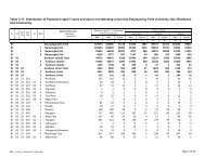
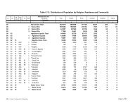
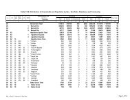
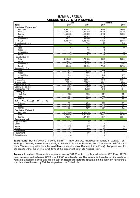
BAMNA UPAZILA<br />
CENSUS RESULTS AT A GLANCE<br />
Zila Upazila<br />
Items<br />
Popul<strong>at</strong>ion (Enumer<strong>at</strong>ed)<br />
2011 2001 2011 2001<br />
Both Sex 8,92,781 8,48,554 79,564 69,803<br />
Male 4,37,413 4,30,322 39,438 34,721<br />
Female 4,55,368 4,18,232 40,126 35,082<br />
Urban 76,927 62,902 0 0<br />
Other Urban 26,167 24,680 7,744 7,106<br />
Rural 7,89,687 7,60,972 71,820 62,697<br />
Annual growth r<strong>at</strong>e<br />
Sex R<strong>at</strong>io<br />
0.5 0.90 1.3 0.57<br />
Total 96 103 98 99<br />
Urban 104 118 0 0<br />
Other Urban 98 104 98 105<br />
Rural<br />
Households (HH)<br />
95 102 98 98<br />
Total 2,15,842 1,79,968 19,537 15,201<br />
Urban 18,403 13,554 0 0<br />
Other Urban 6,379 5,315 1,784 1,462<br />
Rural<br />
Average HH Size<br />
1,91,060 1,61,099 17,753 13,739<br />
Total 4.12 4.72 4.06 4.58<br />
Urban 4.11 4.66 0 0<br />
Other Urban 4.10 4.63 4.33 4.79<br />
Rural 4.12 4.73 4.03 4.56<br />
Area sq. km 1831.31 1831.31 101.05 101.05<br />
Area sq. mile 707.07 707.07 39.01 39.01<br />
Density per sq. km 488 463 787 691<br />
Density per sq. mile 1263 1200 2039 1789<br />
Urbaniz<strong>at</strong>ion (%)<br />
Literacy (%)<br />
11.55 10.32 9.73 10.18<br />
Both Sex 57.6 55.3 61.1 64.2<br />
Male 59.2 57.7 63.0 66.6<br />
Female<br />
School Attendance (5 to 24 years) (%)<br />
56.1 52.8 59.3 61.9<br />
Both Sex 59.1 45.9 57.9 53.2<br />
Male 62.7 48.8 60.9 57.0<br />
Female<br />
Popul<strong>at</strong>ion (Adjusted)<br />
55.7 42.9 55.1 49.4<br />
Both Sex 9,27,890 8,87,678 82,608 72,915<br />
Male 4,54,636 4,50,189 40,947 36,268<br />
Female<br />
Geographic Unit<br />
4,73,254 4,37,489 41,661 36,647<br />
Upazila/Thana 5 5<br />
Union 42 38 4 4<br />
Mauza 259 257 39 39<br />
Village 562 560 49 49<br />
Paurashava 4 4 0 0<br />
Paura Ward 36 36 0 0<br />
Paura Mahalla 50 51 0 0<br />
Background: Bamna became a police st<strong>at</strong>ion in 1870 and was upgraded to upazila in August, 1983.<br />
Nothing is definitely known about the origin of the upazila name. However, there is a general belief th<strong>at</strong> the<br />
name ‘Bamna’ origin<strong>at</strong>ed from the word Baon, a pseudonym of Brahmin (Hindu Priest). It appears from the<br />
zila gazetteer th<strong>at</strong> the original inhabitants of this area might belong to Austrict origin.<br />
Area and Loc<strong>at</strong>ion: The upazila occupies an area of 101.05 sq.km. It is loc<strong>at</strong>ed between 22º11' and 22º21'<br />
north l<strong>at</strong>itudes and between 90º00' and 90º07' east longitudes. The upazila is bounded on the north by<br />
Kanthalia upazila of Barisal zila. on the east by Betagi and <strong>Barguna</strong> upazilas, on the south by P<strong>at</strong>hargh<strong>at</strong>a<br />
upazila and on the west by M<strong>at</strong>hbaria upazila of the Barisal zila.