Cal Stadium Renovation - Trimble
Cal Stadium Renovation - Trimble
Cal Stadium Renovation - Trimble

Create successful ePaper yourself
Turn your PDF publications into a flip-book with our unique Google optimized e-Paper software.
Surveying Sunken Suburbs in<br />
Christchurch’s “Orange Zone”<br />
After the June earthquake, engineers divided Christchurch<br />
into four zones representing whether repair<br />
and rebuilding were viable: green—yes; red—no;<br />
orange—need more data; and white—not yet mapped.<br />
Approximately 9,000 properties comprising the orange zone<br />
needed to be quickly surveyed to better determine whether<br />
they were “red” or “green.” For many of these properties, the<br />
main problem was land sinkage resulting from liquefaction—<br />
some land had sunk by up to 1.5 m (4.9 ft), making it less<br />
able to support construction. Engineers required survey<br />
data to understand what would be needed to bring land<br />
back above the flood level—and to determine whether it<br />
was worthwhile economically to do so.<br />
Tonkin & Taylor, Ltd, geotechnical consultants working for<br />
the Canterbury Earthquake Recovery Authority (CERA),<br />
awarded the Orange-zone survey contract to Paterson<br />
Pitts, providers of land survey and resource management<br />
services to New Zealand’s Otago region. GeoSystems<br />
New Zealand, Ltd, provided nine additional surveying<br />
systems comprising <strong>Trimble</strong> R8 GNSS Rovers and <strong>Trimble</strong><br />
TSC3 Controllers running <strong>Trimble</strong> Access Field Software.<br />
The company’s iBASE Network, based on <strong>Trimble</strong> VRS<br />
technology, has reference stations installed inside and<br />
outside the quake zone and provided control; access to<br />
the network was free for all surveyors during the initial<br />
recovery period.<br />
Due to the large surveying area, time constraints and number<br />
of surveyors from different companies, the project’s<br />
success relied on all data being consistent. “We couldn’t<br />
afford to have any mistakes,” said Paterson Pitts Project<br />
Manager Mike Botting. “People’s livelihoods and properties<br />
were at stake.” To ensure that consistency, GNSS surveying<br />
expert Reece Gardner of 3D World in Christchurch defined<br />
all surveying procedures for the project. Gardner was also<br />
responsible for processing, quality checking and ensuring<br />
data completeness.<br />
Up to 20 surveying teams were on the ground each day;<br />
at peak demand, the iBASE network reached a record<br />
number of concurrent users. Surveyors focused on the<br />
Technology&more; 2012-1<br />
Earthquake Recovery in<br />
-8-<br />
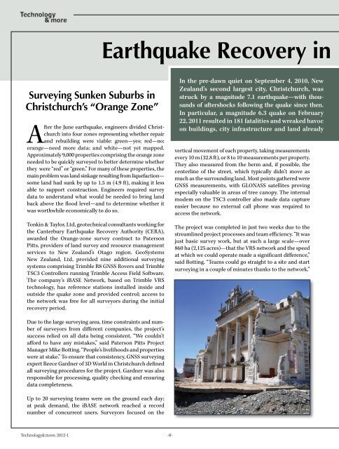
In the pre-dawn quiet on September 4, 2010, New<br />
Zealand’s second largest city, Christchurch, was<br />
struck by a magnitude 7.1 earthquake—with thousands<br />
of aftershocks following the quake since then.<br />
In particular, a magnitude 6.3 quake on February<br />
22, 2011 resulted in 181 fatalities and wreaked havoc<br />
on buildings, city infrastructure and land already<br />
vertical movement of each property, taking measurements<br />
every 10 m (32.8 ft), or 8 to 10 measurements per property.<br />
They also measured from the berm and, if possible, the<br />
centerline of the street, which typically didn’t move as<br />
much as the surrounding land. Most points gathered were<br />
GNSS measurements, with GLONASS satellites proving<br />
especially valuable in areas of tree canopy. The internal<br />
modem on the TSC3 controller also made data capture<br />
easier because no external call phone was required to<br />
access the network.<br />
The project was completed in just two weeks due to the<br />
streamlined project processes and team efficiency. “It was<br />
just basic survey work, but at such a large scale—over<br />
860 ha (2,125 acres)—that the VRS network and the speed<br />
at which we could operate made a significant difference,”<br />
said Botting. “Teams could go straight to a site and start<br />
surveying in a couple of minutes thanks to the network.”