Cal Stadium Renovation - Trimble
Cal Stadium Renovation - Trimble
Cal Stadium Renovation - Trimble

Create successful ePaper yourself
Turn your PDF publications into a flip-book with our unique Google optimized e-Paper software.
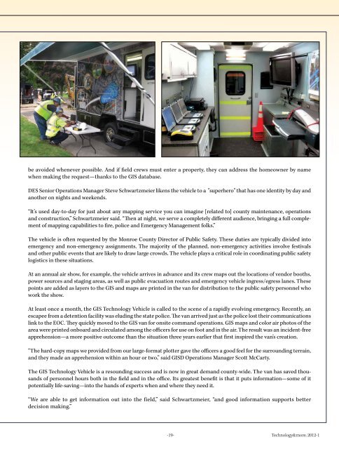
e avoided whenever possible. And if field crews must enter a property, they can address the homeowner by name<br />
when making the request—thanks to the GIS database.<br />
DES Senior Operations Manager Steve Schwartzmeier likens the vehicle to a "superhero" that has one identity by day and<br />
another on nights and weekends.<br />
“It’s used day-to-day for just about any mapping service you can imagine [related to] county maintenance, operations<br />
and construction,” Schwartzmeier said. “Then at night, we serve a completely different audience, bringing a full complement<br />
of mapping capabilities to fire, police and Emergency Management folks.”<br />
The vehicle is often requested by the Monroe County Director of Public Safety. These duties are typically divided into<br />
emergency and non-emergency assignments. The majority of the planned, non-emergency activities involve festivals<br />
and other public events that are likely to draw large crowds. The vehicle plays a critical role in coordinating public safety<br />
logistics in these situations.<br />
At an annual air show, for example, the vehicle arrives in advance and its crew maps out the locations of vendor booths,<br />
power sources and staging areas, as well as public evacuation routes and emergency vehicle ingress/egress lanes. These<br />
points are added as layers to the GIS and maps are printed in the van for distribution to the public safety personnel who<br />
work the show.<br />
At least once a month, the GIS Technology Vehicle is called to the scene of a rapidly evolving emergency. Recently, an<br />
escapee from a detention facility was eluding the state police. The van arrived just as the police lost their communications<br />
link to the EOC. They quickly moved to the GIS van for onsite command operations. GIS maps and color air photos of the<br />
area were printed onboard and circulated among the officers for use on foot and in the air. The result was an incident-free<br />
apprehension—a more positive outcome than the situation three years earlier that first inspired the van’s creation.<br />
“The hard-copy maps we provided from our large-format plotter gave the officers a good feel for the surrounding terrain,<br />
and they made an apprehension within an hour or two,” said GISD Operations Manager Scott McCarty.<br />
The GIS Technology Vehicle is a resounding success and is now in great demand county-wide. The van has saved thousands<br />
of personnel hours both in the field and in the office. Its greatest benefit is that it puts information—some of it<br />
potentially life-saving—into the hands of experts when and where they need it.<br />
“We are able to get information out into the field,” said Schwartzmeier, “and good information supports better<br />
decision making.”<br />
-19- Technology&more; 2012-1