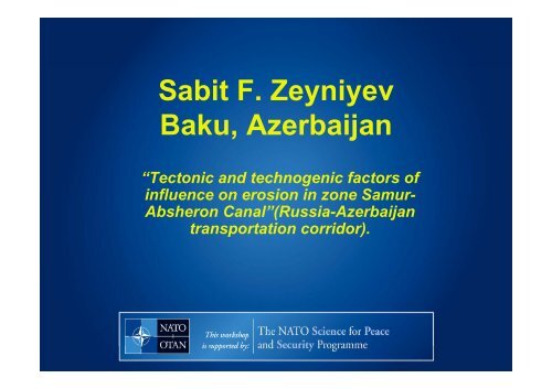
Sabit F. Zeyniyev Baku, Azerbaijan
Sabit F. Zeyniyev Baku, Azerbaijan
Sabit F. Zeyniyev Baku, Azerbaijan

Create successful ePaper yourself
Turn your PDF publications into a flip-book with our unique Google optimized e-Paper software.
<strong>Sabit</strong> F. <strong>Zeyniyev</strong><br />
<strong>Baku</strong>, <strong>Azerbaijan</strong><br />
“Tectonic and technogenic factors of<br />
influence on erosion in zone Samur-<br />
Absheron Canal”(Russia-<strong>Azerbaijan</strong><br />
transportation corridor).
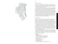
The map of <strong>Azerbaijan</strong>
The investigated area
Samur-Apsheron Canal (SAC) passes at east spurs Large<br />
Caucasian ridge in dust powder, loess-like loams, in thicker<br />
gayness clays. Extent of the canal - 182 kms.<br />
Some circumstances make this corridor important for<br />
scientists and government :<br />
• Extreme density of infrastructure along the river Samur -<br />
SAC - Djeyranbatan reservoir hydroengineering system (oilpipeline,<br />
railroad, gas-pipeline etc.);<br />
• Frequentative crossings of the SAC and <strong>Baku</strong>-<br />
Novorossiysk oil-pipeline;<br />
• High seismic activity of region;
Samur-Apsheron Canal passes along the international<br />
transport corridor " Silk Road ". High density of an<br />
infrastructure of this corridor at coast of the Caspian sea in<br />
itself does all system very vulnerable for.<br />
Brief list of some basic elements of infrastructure of the given<br />
transport corridor:<br />
• Samur-Apsheron Canal;<br />
• <strong>Baku</strong>-Moscow highway;<br />
• <strong>Baku</strong>-Moscow trunk-railway;<br />
• <strong>Baku</strong>-Novorossiysk oil-pipe line;<br />
• <strong>Azerbaijan</strong>-Russia gas pipeline;<br />
• <strong>Azerbaijan</strong>-Russia high-voltage line;<br />
• Shollar-1 water-pipeline;<br />
• Shollar-2 water-pipeline;
Geological and geographical information<br />
As a result of tectonic division into districts in a northeast<br />
part of <strong>Azerbaijan</strong> have been allocated a number of large<br />
structures: Kusaro-Divichinsky, Tengi-Beshbarmaksky,<br />
Sudursky, Shahdag-Hizinsky, and also a number of<br />
structures of the lowest rank.<br />
Territories of the named structures, are studied at<br />
qualitatively different levels as concerning tectonic<br />
processes, character of a parity of superficial and deep<br />
structures, allocation of structural floors etc. opinions of<br />
researchers do not coincide. These discrepancies are<br />
connected, obviously, not only with the subjective factor,<br />
but also to a lesser degree with various volume of an actual<br />
material.
On geodynamic conditions of formation of structural<br />
complexes and floors tectonic structures of region are<br />
dismembered on geosynclinal and orogenic. So, the most<br />
northern, Kusaro-Divichinsky tectonic zone is allocated as<br />
later orogenic floor Alpine orogenic complex. All these<br />
structural complexes are characterized from the point of view<br />
of distribution to their limits of geological formations and<br />
features of geotectonic development.
In our researches these data in a certain measure are used as the<br />
important geological criteria of an estimation of natural tectonic and<br />
seismic estimations of influence on SAC.<br />
For the last half a century in zone SAK are spent and works on<br />
neotectonics studying proceed. Despite rather short time, the saved<br />
up information is considerable and various. Results of long-term<br />
researches are generalised in a neotectonic card of <strong>Azerbaijan</strong> of<br />
M 1:500000 , published in 1991. Within the Kusaro-Divichinsky<br />
tectonic step on a mode of display of the newest tectonic<br />
movements various zones are allocated.
Questions of seismicity and seismotectonics of region of an<br />
arrangement of the Samur-Apsheronsky channel are considered in<br />
works.During purposeful researches of seismicity and<br />
seismotectonics of <strong>Azerbaijan</strong>, 4 cards of seismic division into<br />
districts have been made at least. Last two cards are published in<br />
1968г. And 1980г. On a card 1968г. Almost all territory of southeast<br />
caucasus is allocated as a 7-mark zone.<br />
It is necessary to notice, that according to statistical data\in 1965-<br />
1976гг., were observed about 20 notable, strong and catastrophic<br />
earthquakes in zone SAC
Considerable earthquakes in region after introduction in a system<br />
of the Samur-Apsheronsky channel were Hachmassky<br />
(09.11.1966г.), Caspian (18.09.1961г. And 27.01.1963г). The<br />
Caspian earthquakes have occurred from the same centre located<br />
approximately in 60 km from coast in water area of the sea. The<br />
configuration isoseist both earthquakes is very similar. 7-mark<br />
isoseist covers a narrow coastal strip along the Samur-<br />
Apsheronsky channel around settlements Divichi, Siazan, Zarat,<br />
Gylezi and further in a direction of Sumgait. About the same it is<br />
established for Kyzylburunsky earthquake 1962г., with that only a<br />
difference, that epicentre of the last is located in 7-10 km from<br />
coast. Besides, the maximum force of earthquake reached 7 points<br />
around settlement Siazan, i.e. in central zone SAC.
Long supervision and field works in zone SAC has allowed to reveal<br />
funneled (V-shaped) deposits and destructions in a channel cut. Found out<br />
V-shaped objects are the indicator of presence of a zone of tectonic<br />
destruction. Depending on character of tectonic infringement, it can be not<br />
a funnel, but only its one forming. As a result of the spent researches it has<br />
appeared, that tectonic infringements make huge impact on many parties<br />
SAC, and this influence does not depend on capacity of a sedimentary<br />
cover. So, the pedigree column which is directly over tectonic infringement,<br />
is characterized by the highest infringements. Being in broken and in<br />
raising breaking condition, this pedigree column has, naturally, raised<br />
pliability. That is, any engineering constructions, in particular SAC as the<br />
lengthy object crossing zones of tectonic infringements, bends and deflects<br />
in these zones.
Similar process is observed in soil roads along the channel.<br />
Actually, upon, on places deposits of a concrete wall of the<br />
channel, on the same site are expensive to have constantly to pour<br />
a ground or gravel. Thus, the road and the channel simultaneously<br />
cross a site of tectonic infringement and are submitted to its<br />
influence. On line SAC of such sites of the channel and the road,<br />
demanding regular repair a little. Two almost parallel forming Vshaped<br />
objects are indication of a zone of tectonic infringement.
There is a question why in zones of tectonic infringements thick<br />
concrete walls of the channel not simply sag in connection with the<br />
lowered bearing ability of a ground, and by all means are torn,<br />
burst. Not excepting other explanations, it is possible to assume,<br />
that in zones of tectonic infringements pulsations of rocks take<br />
place. Presence of a pulsation of a ground leads to that the channel<br />
as the lengthy object which crosses a zone of tectonic infringement,<br />
leans simultaneously both on motionless, and on a pulsing ground.<br />
As a result, it is under constant sign-variable violence that will<br />
necessarily lead to development at first micro, and then and<br />
macrocracks.
We observed the erosion and destruction SAC sites which<br />
breakdown susceptibility also is defined by influence of zones of<br />
tectonic infringements. However the breakdown susceptibility<br />
mechanism here absolutely other. These are sites SAC near to<br />
zones of military units and military ranges. Feature of such zones is<br />
presence of vibrating heavy caterpillar technics and artillery volleys.
SAC reaches 187 kilometers from Samur hydrounit on border with<br />
Dagestan, and to avoid crossing of zones of tectonic infringements is<br />
impossible. But the knowledge of the mechanism of influence of these<br />
zones on condition SAC and other engineering facilities certainly will<br />
help to find means to neutralize it. And especially, at transition under<br />
the rivers. After all channels of the rivers it is obligatory zones of<br />
tectonic infringements, and it defines such high breakdown<br />
susceptibility ducers. However, unlike other similar sites, under<br />
channels of the rivers deeply under the soil, therefore destructions of<br />
these sites it is difficult to observe sites of transition of the channel. As<br />
a rule, such destructions lead to loss of a part of proceeding water. In<br />
crossings with channels, water leak moves with water of the river and<br />
it is difficult to supervise and restore such destructions.