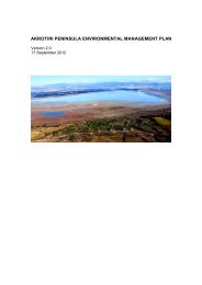
- Page 1 and 2: Consulting CYPRUS FINAL REPORT June
- Page 3 and 4: Consulting CYPRUS 4.4.4 Status of P
- Page 5 and 6: Consulting CYPRUS List of Figures F
- Page 7 and 8: Consulting CYPRUS Figure 41: Period
- Page 9 and 10: Consulting CYPRUS Table 27: The inf
- Page 11 and 12: Consulting CYPRUS 1.1 Structure of
- Page 13 and 14: Consulting CYPRUS Date Objective Wh
- Page 15 and 16: Consulting CYPRUS reference values
- Page 17 and 18: Consulting CYPRUS 3 Legal requireme
- Page 19 and 20: Consulting CYPRUS Urban Waste Water
- Page 21 and 22: Consulting CYPRUS new canal is unde
- Page 23 and 24: Consulting CYPRUS o Water flows fro
- Page 25 and 26: Consulting CYPRUS overtake the sand
- Page 27 and 28: Consulting CYPRUS Point 39 Marsh La
- Page 29 and 30: Consulting CYPRUS Comments: The wat
- Page 31 and 32: Consulting CYPRUS Figure 13: Flow m
- Page 33 and 34: Consulting CYPRUS Port flows Port W
- Page 35 and 36: Consulting CYPRUS Table 2: Values o
- Page 37: Consulting CYPRUS Figure 18: Regres
- Page 41 and 42: Consulting CYPRUS Figure 20: View o
- Page 43 and 44: Consulting CYPRUS Figure 23: Middle
- Page 45 and 46: Consulting CYPRUS the lake bed as t
- Page 47 and 48: Consulting CYPRUS The species marke
- Page 49 and 50: Consulting CYPRUS Afghanistan, Kaza
- Page 51 and 52: Consulting CYPRUS Figure 25: Underw
- Page 53 and 54: Consulting CYPRUS However, parasiti
- Page 55 and 56: Consulting CYPRUS Figure 27: Report
- Page 57 and 58: Consulting CYPRUS Aphanius is an av
- Page 59 and 60: Consulting CYPRUS the only bird spe
- Page 61 and 62: Consulting CYPRUS Species name Stat
- Page 63 and 64: Consulting CYPRUS the reference con
- Page 65 and 66: Consulting CYPRUS -2.0 Response 8.0
- Page 67 and 68: Consulting CYPRUS disturbance indic
- Page 69 and 70: Consulting CYPRUS tabernaemontani (
- Page 71 and 72: Consulting CYPRUS Characteristic sp
- Page 73 and 74: Consulting CYPRUS Characteristic sp
- Page 75 and 76: Consulting CYPRUS grazing causes th
- Page 77 and 78: Consulting CYPRUS Table 9: Biologic
- Page 79 and 80: Habitat Type Consulting CYPRUS impa
- Page 81 and 82: Consulting CYPRUS Habitat Type Impa
- Page 83 and 84: Consulting CYPRUS Based on the abov
- Page 85 and 86: Consulting CYPRUS Table 13: List an
- Page 87 and 88: Consulting CYPRUS
- Page 89 and 90:
Consulting CYPRUS 5 Model Conceptua
- Page 91 and 92:
Consulting CYPRUS 2011) the restaur
- Page 93 and 94:
Consulting CYPRUS introduces heavy
- Page 95 and 96:
Consulting CYPRUS 6 Reference Condi
- Page 97 and 98:
Consulting CYPRUS 6.2 Setting of Re
- Page 99 and 100:
Consulting CYPRUS 6.2.1 Hydrology T
- Page 101 and 102:
Consulting CYPRUS 6.2.3 Macroinvert
- Page 103 and 104:
Consulting CYPRUS Water samples for
- Page 105 and 106:
Consulting CYPRUS 6.2.5 Reference c
- Page 107 and 108:
Consulting CYPRUS local habitat (Hu
- Page 109 and 110:
Consulting CYPRUS 7 Proposed Monito
- Page 111 and 112:
Consulting CYPRUS Figure 43:Flow me
- Page 113 and 114:
Consulting CYPRUS During the visit
- Page 115 and 116:
Consulting CYPRUS 7.1.3 Water Quali
- Page 117 and 118:
Consulting CYPRUS Water Quality Mon
- Page 119 and 120:
Consulting CYPRUS 7.2 Flora and hab
- Page 121 and 122:
Consulting CYPRUS Vegetation Habita
- Page 123 and 124:
Consulting CYPRUS of bioindicator s
- Page 125 and 126:
Consulting CYPRUS base for monitori
- Page 127 and 128:
Consulting CYPRUS • It helpful fo
- Page 129 and 130:
Consulting CYPRUS 129
- Page 131 and 132:
Consulting CYPRUS name confirmed *
- Page 133 and 134:
Consulting CYPRUS • All types of
- Page 135 and 136:
Consulting CYPRUS 7.2.5 Monitoring
- Page 137 and 138:
Consulting CYPRUS The population si
- Page 139 and 140:
Consulting CYPRUS Specimens should
- Page 141 and 142:
Consulting CYPRUS Scheme Organiser
- Page 143 and 144:
Consulting CYPRUS In Tables, the ta
- Page 145 and 146:
Consulting CYPRUS Attributes Target
- Page 147 and 148:
Consulting CYPRUS Table 18: Guidanc
- Page 149 and 150:
Consulting CYPRUS throughout Akroti
- Page 151 and 152:
Consulting CYPRUS Attributes Target
- Page 153 and 154:
Consulting CYPRUS Attributes Target
- Page 155 and 156:
Consulting CYPRUS Attributes Target
- Page 157 and 158:
Consulting CYPRUS Sandplover (Chara
- Page 159 and 160:
Consulting CYPRUS Attributes Target
- Page 161 and 162:
Consulting CYPRUS Attributes Target
- Page 163 and 164:
Consulting CYPRUS Table 25: Guidanc
- Page 165 and 166:
Consulting CYPRUS Kentish Plover Th
- Page 167 and 168:
Consulting CYPRUS The counting unit
- Page 169 and 170:
Consulting CYPRUS species, e.g. Per
- Page 171 and 172:
Consulting CYPRUS that blend agains
- Page 173 and 174:
Consulting CYPRUS Attributes Target
- Page 175 and 176:
Consulting CYPRUS Attributes Target
- Page 177 and 178:
Consulting CYPRUS Moreover, it is d
- Page 179 and 180:
Consulting CYPRUS bio-indicators of
- Page 181 and 182:
Consulting CYPRUS expected to dry u
- Page 183 and 184:
Consulting CYPRUS 7.8.1 Additional
- Page 185 and 186:
Consulting CYPRUS 8 References Alle
- Page 187 and 188:
Consulting CYPRUS EEC 1992. Council
- Page 189 and 190:
Consulting CYPRUS McCulloch, G G.P.
- Page 191 and 192:
Consulting CYPRUS Trees and shrubs
- Page 193 and 194:
Consulting CYPRUS Appendix I MAPS 1
- Page 195 and 196:
Consulting CYPRUS A. Communities id
- Page 197 and 198:
Consulting CYPRUS B. Communities id
- Page 199 and 200:
Consulting CYPRUS Attributes of the
- Page 201 and 202:
Consulting CYPRUS Taxon Asphodelus
- Page 203 and 204:
Consulting CYPRUS Taxon orientale C
- Page 205 and 206:
sp. Consulting CYPRUS Taxon Coridot
- Page 207 and 208:
Consulting CYPRUS Taxon Vegetation
- Page 209 and 210:
Consulting CYPRUS Taxon Helianthemu
- Page 211 and 212:
Consulting CYPRUS Taxon Vegetation
- Page 213 and 214:
Consulting CYPRUS Taxon Medicago ma
- Page 215 and 216:
Consulting CYPRUS Taxon Vegetation
- Page 217 and 218:
Consulting CYPRUS Taxon Vegetation
- Page 219 and 220:
Consulting CYPRUS Taxon Vegetation
- Page 221 and 222:
Consulting CYPRUS Taxon Vegetation
- Page 223 and 224:
Consulting CYPRUS Annex A.a: GIS da
- Page 225 and 226:
Consulting CYPRUS Field Description
- Page 227 and 228:
Consulting CYPRUS 227
- Page 229 and 230:
Consulting CYPRUS Transect No: Leng
- Page 231 and 232:
Consulting CYPRUS VEGETATION TRANSE
- Page 233 and 234:
Consulting CYPRUS Annex B.b: Abioti
- Page 235 and 236:
Consulting CYPRUS Location and poly
- Page 237 and 238:
Consulting CYPRUS 237
- Page 239 and 240:
Consulting CYPRUS Appendix III Grou
- Page 241 and 242:
Consulting CYPRUS 241
- Page 243 and 244:
Consulting CYPRUS 243
- Page 245 and 246:
Consulting CYPRUS 245
- Page 247 and 248:
Consulting CYPRUS 247
- Page 249 and 250:
884 HRA Runway Lights