May 17, 2011 Mr. Joseph T. Martella II - Rhode Island Department of ...
May 17, 2011 Mr. Joseph T. Martella II - Rhode Island Department of ...
May 17, 2011 Mr. Joseph T. Martella II - Rhode Island Department of ...

Create successful ePaper yourself
Turn your PDF publications into a flip-book with our unique Google optimized e-Paper software.
<strong>May</strong> <strong>17</strong>, <strong>2011</strong><br />
<strong>Mr</strong>. <strong>Joseph</strong> T. <strong>Martella</strong> <strong>II</strong>, Senior Engineer<br />
RIDEM Office <strong>of</strong> Waste Management<br />
Site Remediation Program<br />
235 Promenade Street<br />
Providence, RI 02908<br />
RE: Park Parcel Phase I<br />
Recommended Remedial Action<br />
Former Gorham Manufacturing Facility<br />
333 Adelaide Avenue, Providence, <strong>Rhode</strong> <strong>Island</strong><br />
MACTEC Project No. 3650100157.01<br />
Dear <strong>Mr</strong>. <strong>Martella</strong>:<br />
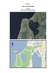
On behalf <strong>of</strong> Textron, this letter summarizes the recommended remedial action for the Phase I area <strong>of</strong> the<br />
Park Parcel on Parcel D <strong>of</strong> the Former Gorham Manufacturing Site in Providence, <strong>Rhode</strong> <strong>Island</strong> (Figure<br />
1). The Phase I area extends from the western end <strong>of</strong> Adelaide Avenue north and east to the storm water<br />
detention basin behind the retail building. The original remedial approach was selected from among the<br />
three alternatives, presented in the July 2006 Supplemental Site Investigation Report (SIR) and June 2007<br />
Supplemental SIR Addendum, and as detailed in the July 2007 Draft Remedial Action Work Plan<br />
(RAWP).<br />
Based on recent discussions between Textron and the <strong>Rhode</strong> <strong>Island</strong> <strong>Department</strong> <strong>of</strong> Environmental<br />
Management (RIDEM), the Phase I area remediation <strong>of</strong> the Park Parcel has been revised to incorporate<br />
the following documents and actions:<br />
Supplemental remedial actions outlined in the Supplemental Removal Action Work Plan, dated<br />
October 26, 2006, regarding additional response actions at the former slag pile area;<br />
Response to RIDEM Comments by Textron, dated February 26, 2007, confirming the supplemental<br />
response actions at the former slag pile;<br />
Supplemental SIR Addendum, dated June 28, 2007, summarizing additional soil analysis for dioxin<br />
and proposed soil removal on the Park Parcel western peninsula; and,<br />
Results <strong>of</strong> the site walk <strong>of</strong> RIDEM and MACTEC in August 2010 regarding the extent <strong>of</strong> the soil<br />
cover and impermeable cap over the former slag pile area.<br />
MACTEC Engineering and Consulting, Inc.<br />
107 Audubon Road, Bldg. 2, Suite 301 • Wakefield, MA 01880 • Phone: 781-245-6606 • Fax: 781-246-5060
Textron, Inc. Former Gorham Facility, Providence, RI – Park Parcel Phase I, Recommended RA <strong>May</strong> <strong>17</strong>, <strong>2011</strong><br />
MACTEC Engineering and Consulting, Inc. Project Number 3650-10-0157.01 Page 2<br />
Park Parcel Phase I Remediation<br />
A phased remediation approach has been developed for the entire Park Parcel. Phase I will occur first and<br />
includes the portion <strong>of</strong> the Park Parcel that is closest to the High School (Parcel B) and proposed open<br />
space/fields (Parcel C). Phase <strong>II</strong> consists <strong>of</strong> Mashapaug Cove and Phase <strong>II</strong>I consists <strong>of</strong> the open area<br />
north <strong>of</strong> the stormwater detention basin that will be used for the staging <strong>of</strong> materials and equipment<br />
necessary to complete Phase I and Phase <strong>II</strong> activities. This area will be referred to as the “lay down” area<br />
for the remainder <strong>of</strong> this document. Groundwater remediation is also being planned for the former<br />
Gorham Site.<br />
Western Shoreline Soil Excavation<br />
Concentrations <strong>of</strong> polynuclear aromatic hydrocarbons (PAHs), lead and dioxin exceeding RIDEM’s<br />
applicable cleanup standards were detected in surface soils along the western shoreline <strong>of</strong> Parcel D.<br />
These isolated locations will be excavated and the soil moved to a nearby area <strong>of</strong> the Phase I Park Parcel<br />
proposed for soil cover. These soil removal areas include the southwestern corner <strong>of</strong> Parcel D at SS-<br />
210/SS-SI210 (PAHs and lead) within a storm water drainage ditch (Attachment A, Drawing C-106) and<br />
two locations on the western peninsula near SS-206 (lead and dioxin), as shown on Attachment A,<br />
Drawing C-101. Soil will be removed from these areas, approximately 10 feet x 10 feet to a depth <strong>of</strong> one<br />
foot below ground surface. Confirmatory soil samples will be collected from the bottom <strong>of</strong> the<br />
excavation areas for comparison to RI Residential DEC for PAHs, metals and risk-based derived dioxin<br />
concentration <strong>of</strong> 0.0043 micrograms per kilogram (µg/kg) (July 2006 SIR and June 2007 SIR Addendum).<br />
Once these cleanup criteria are met, the three areas will be backfilled with clean material.<br />
The excavated area at SS-210/SS-SI210 will be covered with geotextile fabric and backfilled with stone<br />
from the Former Slag Pile stockpile in order to secure this area within the storm water drainage ditch.<br />
The two western peninsula locations will be backfilled with clean soil meeting RI residential DEC<br />
criteria. Limited tree clearing will be conducted to access these locations and support the removal <strong>of</strong> soil<br />
and backfill with clean material.<br />
Former Slag Area Removal and Testing<br />
In response to RIDEM comments regarding the potential leaching <strong>of</strong> metals from the soil within the<br />
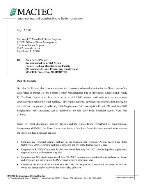
former slag pile area, soil will be excavated at two locations in the former slag pile area (Figure 2) and<br />
transported <strong>of</strong>fsite for disposal. Following removal <strong>of</strong> soil from the two locations, up to ten test pits will<br />
be conducted along the perimeter <strong>of</strong> the former slag pile removal area (Figure 2) and at locations within
Textron, Inc. Former Gorham Facility, Providence, RI – Park Parcel Phase I, Recommended RA <strong>May</strong> <strong>17</strong>, <strong>2011</strong><br />
MACTEC Engineering and Consulting, Inc. Project Number 3650-10-0157.01 Page 3<br />
the former slag pile. These test pit locations will be coordinated with RIDEM. Confirmatory soil<br />
sampling will be conducted at the excavations and test pits for total lead and Synthetic Precipitation<br />
Leaching Procedure (SPLP) for metals. This data will be used to determine future soil management<br />
requirements, as necessary.<br />
Park Parcel Soil Cap<br />
The Phase I remedial action will also include the installation <strong>of</strong> soil caps as shown on Attachment A,<br />
Drawings C-104, C-105 and C-106. The soil caps will cover historic fill material, prevent direct contact<br />
exposure, and restrict the potential migration <strong>of</strong> contaminants through the action <strong>of</strong> wind erosion and<br />
surface run-<strong>of</strong>f into Mashapaug Pond. The low-permeability section <strong>of</strong> the cap above the former slag area<br />
will restrict water infiltration and reduce potential leaching <strong>of</strong> metals from vadose zone soil to<br />
groundwater. This is viewed as a conservative measure as historic groundwater monitoring data from<br />
monitoring well GZA-5, which was located within the footprint <strong>of</strong> the former slag pile prior to its<br />
removal, did not indicate that metals were leaching from the slag pile.<br />
The Phase I soil cap contains three distinct components. These components are color-coded on<br />
Attachment A, Drawings C-104, C-105 and C-106, and include a fill area cap (blue), a wetland buffer cap<br />
(green), and a former slag area cap (yellow). Refer to Attachment A, Drawing C-503 for cross sections <strong>of</strong><br />
the cap across Phase I. Trees located within the proposed cap areas will be removed and chipped prior to<br />
grading and construction <strong>of</strong> the soil caps; however, the contractor will attempt to save larger trees if<br />
possible and appropriate.<br />
Fill Area Cap: The fill area extends along the top <strong>of</strong> the western slope and extends along the shoreline <strong>of</strong><br />
the Mashapaug Inner Cove (Attachment A, Drawings C-104, C-105 and C-106). This fill material<br />
consists <strong>of</strong> casting sands, concrete, rubble, and other debris. The fill was historically characterized<br />
through soil borings and test pits. Soil excavated from SS-210/SS-SI210 will be spread within the<br />
southwestern most fill area (Attachment A, Drawing C-106) and capped. Soil removed from the western<br />
peninsula will be spread under the fill area cap south <strong>of</strong> Mashapaug Inner Cove. The fill areas (blue) will<br />
be capped with two feet <strong>of</strong> clean soil (18” cover soil and 6” topsoil). The finished surface will be seeded<br />
or stabilized with erosion control matting. The fill area cap located along Parcels B and C will match the<br />
existing grade at the High School and proposed grade at the Parcel C boundaries. Note that the soil cap in<br />
the northwest corner <strong>of</strong> Parcel C has been extended to follow the grade and fill material further down<br />
slope to address elevated PAHs, lead and dioxin concentrations within the drainage swale (SS-SI-001)<br />
(Attachment A, Drawing C-106). The soil cap along the western shoreline has been extended south to the
Textron, Inc. Former Gorham Facility, Providence, RI – Park Parcel Phase I, Recommended RA <strong>May</strong> <strong>17</strong>, <strong>2011</strong><br />
MACTEC Engineering and Consulting, Inc. Project Number 3650-10-0157.01 Page 4<br />
base <strong>of</strong> the 24-inch tree (co-located with SS-106) to encompass the historical lead exceedance found in<br />
this area (Attachment A, Drawing C-106).<br />
Wetland Buffer Cap: As the Park Parcel cap abuts the shore <strong>of</strong> Mashapaug Cove, special considerations<br />
for wetlands have been included as part <strong>of</strong> Phase I. The wetland buffer cap consists <strong>of</strong> the area within 50’<br />
<strong>of</strong> the Inner Cove shoreline. The wetland delineation was completed in <strong>May</strong> 2007 and the location <strong>of</strong> the<br />
wetland boundary and high water mark was surveyed. Refer to Attachment A, Drawings C-104 and C-<br />
105 for the location <strong>of</strong> these site features. The “delineated” wetlands are typically located 5’ to 10’<br />
upland from the shoreline. Thus, the limit <strong>of</strong> work (LOW) for Phase I will be along a 10’ setback from<br />
the shoreline <strong>of</strong> Mashapaug Cove such that all <strong>of</strong> the remediation work within the freshwater wetlands<br />
will be conducted in the future as part <strong>of</strong> the Mashapaug Cove sediment remediation (Phase <strong>II</strong> Park Parcel<br />
remediation). This will allow for improved access to the wetland area for the capping and construction <strong>of</strong><br />
a natural transition zone from the wetlands into the Cove (Attachment A, Drawing C-503). Note that the<br />
wetland cap has been extended to include SD-002 (lead contaminated soil), as shown in Attachment A,<br />
Drawing C-104. In accordance with state regulations, some remediation activities in the wetland buffer<br />
may be exempt from the State wetland permitting requirements as this work is part <strong>of</strong> a remedial action<br />
under the RIDEM Remediation Regulations. These activities will be coordinated with RIDEM to assure<br />
compliance with all applicable regulations. However, future construction work within the Park Parcel not<br />
conducted under the Remediation Regulations will need to comply with all state wetland permitting<br />
requirements and regulations.<br />
Clearing and grubbing <strong>of</strong> the wetland buffer zone scrub material will be conducted, as necessary, to<br />
support the installation <strong>of</strong> the soil cap. One foot <strong>of</strong> soil at the toe <strong>of</strong> the LOW will be removed to allow<br />
the soil cap to key into the existing grade above the wetland boundary. Twelve inches <strong>of</strong> clean soil will<br />
then be spread throughout the buffer zone to provide the soil cap. The finished surface for the wetland<br />
buffer cap will be stabilized with erosion control matting, and wetland vegetation will be planted. The<br />
July 2007 Draft RAWP includes the proposed wetland restoration and planting plan details.<br />
Former Slag Area Cap: Following the grading <strong>of</strong> the existing soil, the former slag area will be capped<br />
with 6” sand, 40-mil geomembrane, drainage composite layer, 12” clean cover soil, and 6” clean fill<br />
topsoil (Attachment A, Drawing C-503). The finished surface <strong>of</strong> the former slag area will be seeded or<br />
stabilized with erosion control matting. The haul road access to the former slag area will be improved<br />
during construction and removed after construction is complete.
Textron, Inc. Former Gorham Facility, Providence, RI – Park Parcel Phase I, Recommended RA <strong>May</strong> <strong>17</strong>, <strong>2011</strong><br />
MACTEC Engineering and Consulting, Inc. Project Number 3650-10-0157.01 Page 5<br />
Fencing: The existing chain link fence will be relocated along the boundary between Parcels C and D,<br />
extending from Adelaide Avenue to the existing chain link fence in the northwest corner <strong>of</strong> the high<br />
school parking lot. The chain link fence and access gate in the northwest corner <strong>of</strong> the retail property will<br />
be replaced or reset and will extend east to the storm water detention basin fencing.<br />
This fence will remain in place until all three phases <strong>of</strong> remediation on the Park Parcel have been<br />
completed or when the City <strong>of</strong> Providence has completed the installation <strong>of</strong> the planned walking path and<br />
fence/plantings along the water side <strong>of</strong> the path to restrict access to the steep slope down to the shoreline<br />
and until the Mashapaug Cove sediments (Phase <strong>II</strong>) and remaining Park Parcel surface soils have been<br />
remediated (Phase <strong>II</strong>I).<br />
Groundwater Monitoring Wells<br />
As groundwater infiltration and flow from the Park Parcel to Mashapaug Pond play a critical role in the<br />
Site conceptual model, MACTEC will restore monitoring well GZA-5 and maintain existing monitoring<br />
wells within the Phase I Cap. These monitoring wells will provide information about groundwater flow<br />
and aid in monitoring <strong>of</strong> remedial actions. Monitoring well GZA-5 was removed during the slag<br />
excavation activities in the summer <strong>of</strong> 2006 and will be re-installed through the Phase I Cap as a shallow<br />
well to straddle the groundwater table (Attachment A, Drawing C-105). The number <strong>of</strong> existing<br />
monitoring wells maintained during the soil cap construction may be modified pending the design <strong>of</strong> the<br />
groundwater treatment system and monitoring network.<br />
Existing monitoring wells within the cap (e.g., GZA-3) will be secured and maintained during the<br />
construction <strong>of</strong> the soil cap. Also, a new shallow monitoring well will be installed on the east side <strong>of</strong> the<br />
former slag area cap, outside the cap and close to the edge <strong>of</strong> the cove. This new well, together with the<br />
reinstalled GZA-5 and MW-237S (located on the west side <strong>of</strong> the former slag area cap), will be included<br />
in a targeted monitoring program for potential leaching <strong>of</strong> metals from the former slag pile area. The<br />
future groundwater monitoring program for the Phase I Park Parcel will be developed within the revised<br />
RAWP for review and approval by RIDEM.<br />
Institutional Controls<br />
An Environmental Land Usage Restriction (ELUR), in accordance with Rule 8.09 <strong>of</strong> the Remediation<br />
Regulations, will be developed with the City <strong>of</strong> Providence or Providence Redevelopment Agency (PRA)<br />
as property owner and RIDEM and recorded with the property deed. A Soil Management Plan (SMP),<br />
which will outline the procedures for managing the soils on site should disturbances below the cap be
Mashapaug Pond<br />
¯ 0 <strong>17</strong>5 350<br />
Feet<br />
Prepared by BJR<br />
Checked by PJM<br />
<br />
Parcel C<br />
Mashapaug<br />
Cove<br />
School<br />
Legend<br />
Park Parcel<br />
Approximate Parcel Boundaries<br />
Document: P:\TEXTRON\GORHAM\GIS\MapDocuments\AerialParcelBoundaries_8X11.mxd PDF: P:\3650100157 - Textron Gorham\4.0 Project Deliverables\4.1 Reports\Park Parcel Phase I Remediation\Figure 1 - Site Location.pdf 05/06/<strong>2011</strong> 10:02 AM bjroden<br />
Retail<br />
Figure 1<br />
Site Location<br />
333 Adelaide Avenue<br />
Providence, RI<br />
MACTEC, Inc.
¯<br />
0 <strong>17</strong>.5 35<br />
Feet<br />
Prepared by BJR Checked by PJM<br />
Appoximate Fill Area<br />
Additional Removal Area<br />
Legend<br />
Test Pit (Final Locations To Be Determined In Field)<br />
Previous Sample Locations<br />
Initially Excavated Area<br />
DCity Fence<br />
Elevation<br />
Approximate Park Parcel Boundary<br />
Mashapaug Cove<br />
Figure 2<br />
Former Slag Pile Area<br />
Supplemental Removal Action<br />
333 Adelaide Avenue<br />
Providence, <strong>Rhode</strong> <strong>Island</strong><br />
Document: P:\TEXTRON\GORHAM\GIS\MapDocuments\ExcavatedArea.mxd PDF: P:\3650100157 - Textron Gorham\4.0 Project Deliverables\4.1 Reports\Park Parcel Phase I Remediation\Figure 2 - Former Slag Pile Area Supplemental Removal Action.pdf 05/06/<strong>2011</strong> 10:46 AM bjroden