European and Asian Fine and Decorative Art - Cowan's Auctions
European and Asian Fine and Decorative Art - Cowan's Auctions
European and Asian Fine and Decorative Art - Cowan's Auctions

Create successful ePaper yourself
Turn your PDF publications into a flip-book with our unique Google optimized e-Paper software.
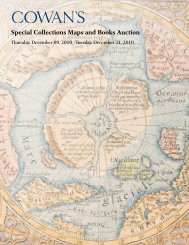
77 uniVersalis tabula i(J)uxta Ptolemaeum<br />
Mercator, Gerard (Gerald). amsterdam, 1720-1730. Second state<br />
of Mercator’s 1578 ptolemaic map with mythological figures<br />
in the corners: Zeus (Fire)with thunderbolts, Hera (air) with<br />
peacock, neptune (Water) with trident, <strong>and</strong> Gaia (Earth) with<br />
fruits <strong>and</strong> vegetables. only the northern part of africa visible, <strong>and</strong><br />
Sc<strong>and</strong>inavia, a small isl<strong>and</strong> near where denmark should be. India<br />
is truncated, but Sri Lanka (labeled Taprobana) is large <strong>and</strong> in the<br />
position of the southern part of subcontinent. often found as a<br />
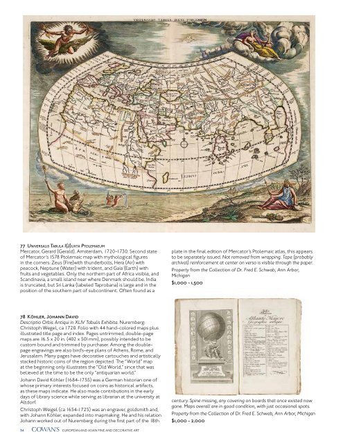
78 Köhler, Johann david<br />
Descriptio Orbis Antiqui in XLIV Tabulis Exhibita. nuremberg:<br />
Christoph Wegel, ca 1720. Folio with 44 h<strong>and</strong>-colored maps plus<br />
illustrated title page <strong>and</strong> index. pages untrimmed, double-page<br />
maps are 16.5 x 20 in. (402 x 501mm), possibly intended to be<br />
custom bound <strong>and</strong> trimmed by purchaser. among the doublepage<br />
engravings are also bird’s-eye plans of athens, rome, <strong>and</strong><br />
Jerusalem. Many pages have decorative cartouches <strong>and</strong> artistically<br />
stacked historic coins of the region depicted. The “World” map<br />
at the beginning only illustrates the “old World,” since that was<br />
believed at the time to be the only “antiquarian world.”<br />
Johann david Köhler (1684-1755) was a German historian one of<br />
whose primary interests focused on coins as historical artifacts,<br />
as these maps indicate. He also made contributions in the early<br />
days of library science while serving as librarian at the university at<br />
altdorf.<br />
Christoph Weigel (ca 1654-1725) was an engraver, goldsmith <strong>and</strong>,<br />
with Johann Köhler, exp<strong>and</strong>ed into mapmaking. He <strong>and</strong> his relation<br />
Johann worked out of nuremberg during the first part of the 18th<br />
34 EuropEan <strong>and</strong> aSIan FInE <strong>and</strong> dECoraTIvE arT<br />
plate in the final edition of Mercator’s ptolemaic atlas, this appears<br />
to be separately issued. Not removed from wrapping. Tape (probably<br />
archival) reinforcement at center on verso is visible through the paper.<br />
Property from the Collection of Dr. Fred E. Schwab, Ann Arbor,<br />
Michigan<br />
$1,000 - 1,500<br />
century. Spine missing, any covering on boards that once existed now<br />
gone. Maps overall are in good condition, with just occasional spots.<br />
Property from the Collection of Dr. Fred E. Schwab, Ann Arbor, Michigan<br />
$1,000 - 2,000