Tanana Lakes Recreation Area Master Plan - Fairbanks North Star ...
Tanana Lakes Recreation Area Master Plan - Fairbanks North Star ...
Tanana Lakes Recreation Area Master Plan - Fairbanks North Star ...

You also want an ePaper? Increase the reach of your titles
YUMPU automatically turns print PDFs into web optimized ePapers that Google loves.
2 Existing Conditions and Land Use<br />
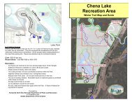
Site Location<br />
The <strong>Tanana</strong> <strong>Lakes</strong> area is located in the FNSB just 10 minutes south of<br />
downtown <strong>Fairbanks</strong>. The area is conveniently located, approximately<br />
14 miles northwest of the City of <strong>North</strong> Pole, and approximately 3 miles<br />
southwest of Fort Wainwright’s main post. The Location and Vicinity Map<br />
(Figure 1) illustrates the general location of the area relative to the surrounding<br />
communities, roadways, and major water bodies.<br />
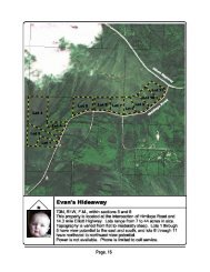
Project Boundary<br />
The project area is comprised of approximately 750 acres. It is located at<br />
Latitude 64.797°N and Longitude -147.737°W, and is within Sections 26, 27,<br />
28, and 34, Township 1 South, Range 1 West, <strong>Fairbanks</strong> Meridian. This site<br />
is generally bound on the north by the <strong>Tanana</strong> River Levee, south by the<br />
<strong>Tanana</strong> River, west by Groin 8 of the <strong>Tanana</strong> River Levee, and east by the<br />
Goose Island Causeway, an extension of South Cushman Street. An outline<br />
of the project boundary is shown on Figure 2.<br />
FNSB - Department of Parks and <strong>Recreation</strong><br />
TANANA LAKES MASTER PLAN 2-1