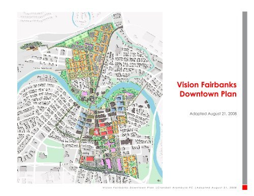
Vision Fairbanks Downtown Plan - Fairbanks North Star Borough
Vision Fairbanks Downtown Plan - Fairbanks North Star Borough
Vision Fairbanks Downtown Plan - Fairbanks North Star Borough

You also want an ePaper? Increase the reach of your titles
YUMPU automatically turns print PDFs into web optimized ePapers that Google loves.
<strong>Vision</strong> <strong>Fairbanks</strong><br />
<strong>Downtown</strong> <strong>Plan</strong><br />
Adopted August 21, 2008<br />
<strong>Vision</strong> <strong>Fairbanks</strong> <strong>Downtown</strong> <strong>Plan</strong> |Crandall Arambula PC |Adopted August 21, 2008
Credits<br />
<strong>Downtown</strong> Association of <strong>Fairbanks</strong><br />
Board of Directors<br />
Therese Sharp, Walsh, Kelliher and Sharp, Board<br />
President<br />
Monty Rostad, Big Ray’s Clothing Store, Board<br />
Vice President<br />
Peter Beaver, General Manager, Sadler’s Home<br />
Furnishings<br />
Charles Bettisworth, Bettisworth & Company<br />
Buzzy Chiu, General Manager, Bridgewater Hotel<br />
Mike Cook, Cook & Haugeberg, Partner<br />
Jeff Hammermeister, General Manager, Westmark<br />
<strong>Fairbanks</strong><br />
Ken Henry, Owner, Hops Stationery<br />
Bart LeBon, Executive Vice President, Commercial<br />
Lending, Mt. McKinley Bank<br />
Sue Rainey, Owner, Riverview Realty<br />
Cindy Schumaker, Project Director, Morris<br />
Thompson Cultural & Visitors Center<br />
Georjean Seeliger, Owner, If Only...<br />
Urban <strong>Plan</strong> Task Force<br />
Charles Bettisworth, Bettisworth & Company<br />
Bruce Carr, Director of Strategic <strong>Plan</strong>ning, Alaska<br />
Railroad<br />
Judy Chapman, Area <strong>Plan</strong>ner Department of<br />
Transportation, State of Alaska<br />
Dr. Kathryn Dodge, Economic Development<br />
Specialist, <strong>Fairbanks</strong> <strong>North</strong> <strong>Star</strong> <strong>Borough</strong><br />
Bernardo Hernandez, Director, Department<br />
of Community <strong>Plan</strong>ning, <strong>Fairbanks</strong> <strong>North</strong> <strong>Star</strong><br />
<strong>Borough</strong><br />
David Jacoby, City of <strong>Fairbanks</strong><br />
Monty Rostad, Big Ray’s Clothing Store<br />
Therese Sharp, Walsh, Kelliher and Sharp<br />
Mike Schmetzer, City Engineer, City of <strong>Fairbanks</strong><br />
Emma Wilson, <strong>Downtown</strong> Association of <strong>Fairbanks</strong><br />
Community Advisory Committee<br />
Emily Bratcher, Regional Development<br />
Coordinator, JL Properties<br />
Joan Busam, Owner, l’assiette de Pomegranate<br />
Maurine Canarsky, <strong>Downtown</strong> Resident<br />
Jim Dodson, President & CEO of <strong>Fairbanks</strong><br />
Economic Development Corporation<br />
Frank Eagle, Owner, Lavelle’s Bistro<br />
Bob Eley, Board President, <strong>Fairbanks</strong> Community<br />
Museum<br />
Julie Estey, Director of Development, University of<br />
Alaska Museum of the <strong>North</strong><br />
Elyse Guttenberg, Director of <strong>Plan</strong>ning &<br />
Development, <strong>Fairbanks</strong> Native Association<br />
Mary Karhhahn-<strong>Star</strong>k, City Resident<br />
Shirley Lee, Executive Director, <strong>Fairbanks</strong> Native<br />
Association<br />
Jewelz Nutter, President & CEO, Greater <strong>Fairbanks</strong><br />
Chamber of Commerce<br />
Michelle Roberts, Executive Director, Festival<br />
<strong>Fairbanks</strong><br />
June Rogers, Executive Director, <strong>Fairbanks</strong> Arts<br />
Association, Owner, McCafferty’s<br />
Marilyn Russell, City Resident<br />
Tim Staton, Owner, Alaska Gold’n’Gems<br />
Melissa Stepovich, Governor Palin’s Office<br />
Vivian Stiver, Owner, Two Street Station<br />
<strong>Fairbanks</strong> <strong>North</strong> <strong>Star</strong> <strong>Borough</strong><br />
Mayor Jim Whitaker<br />
Bernardo Hernandez, Director, Department of<br />
Community <strong>Plan</strong>ning<br />
Dr. Kathryn Dodge, Economic Development<br />
Specialist<br />
City of <strong>Fairbanks</strong><br />
Mayor Terry Strle<br />
Mayor Steve Thompson<br />
Mike Schmetzer, City Engineer<br />
Gerry Colp, Engineer III<br />
Bob Pristash, Engineer IV<br />
<strong>Downtown</strong> Association of <strong>Fairbanks</strong><br />
Emma Wilson, Director<br />
Jerri Layman, Operations Director<br />
Ingrid Pabon, Community Development Director<br />
Kelly Meeks<br />
FMATS Policy and Technical Committee<br />
Citizens of <strong>Fairbanks</strong> <strong>North</strong> <strong>Star</strong> <strong>Borough</strong><br />
Consultant:<br />
Crandall Arambula PC<br />
George Crandall, Principal<br />
Don Arambula, Principal<br />
Jason N Graf, Associate/Senior Urban Designer<br />
Dawn Sharpnack, Urban Designer<br />
Erin Carter, Urban Designer<br />
Karen Wall, Graphics Coordinator<br />
Julia Reed, Urban Designer<br />
Kinney Engineering<br />
Randy Kinney, Principal<br />
Kelley Hegarty and Associates<br />
Kelley Hegarty, Principal<br />
<strong>Vision</strong> <strong>Fairbanks</strong> <strong>Downtown</strong> <strong>Plan</strong> |Crandall Arambula PC |Adopted August 21, 2008<br />
Credits
Table of Contents<br />
Glossary<br />
<strong>Downtown</strong> <strong>Plan</strong> Area Map<br />
Executive Summary 1<br />
Introduction 2<br />
Why This <strong>Plan</strong> Was Prepared 3<br />
Community Process and Schedule 4<br />
Guiding Principles 5<br />
The Fundamental Concept 6<br />
Land Use Framework 7<br />
Circulation Framework 8<br />
Implementation 9<br />
Developmental Capacity 10<br />
Catalyst Projects 11<br />
Time Sensitive Projects 24<br />
Build Out Projects 28<br />
Schedule 35<br />
Action <strong>Plan</strong>: Catalyst and Time Sensitive Projects 36<br />
Land Use Framework 37<br />
Overview 38<br />
Retail Framework 40<br />
Retail Parking Framework 47<br />
Commercial Framework 48<br />
Civic/Cultural Framework 49<br />
Office Framework 50<br />
Education Framework 51<br />
Residential Framework 52<br />
Squares, Parks & Open Spaces Framework 55<br />
Circulation Framework 65<br />
Overview 66<br />
Automobile and Truck Framework 68<br />
Pedestrian Framework 82<br />
Bicycle Framework 93<br />
Transit Framework 97<br />
<strong>Vision</strong> <strong>Fairbanks</strong> <strong>Downtown</strong> <strong>Plan</strong> |Crandall Arambula PC |Adopted August 21, 2008<br />
Table of Contents
Glossary of Terms<br />
Accessory dwelling unit- A separate additional<br />
living unit, including separate kitchen, sleeping and<br />
bathroom facilities attached or detached from the<br />
primary residential unit, on a single-family lot.<br />
Arcade- A roofed passageway or lane, especially<br />
one with shops on one or both sides.<br />
Awning- A roof-like structure, often made of<br />
canvas, glass, or concrete that serves as a shelter, as<br />
over a storefront, window, door, or deck.<br />
Build-out projects- those projects having the<br />
potential to create downtown development<br />
momentum after initiation or completion of the<br />
catalyst projects.<br />
Catalyst Projects- those projects that have the<br />
ability to stimulate significant new downtown<br />
development and private investment. These projects<br />
need to be initiated or completed before public<br />
funds are used to implement build-out projects.<br />
Capacity diagram- an illustration identifying the<br />
character and intensity of new development within a<br />
given area over the next 20 years.<br />
Civic forest- a design concept for organizing<br />
the civic uses along the sound end of Cushman<br />
Street around a landscaping theme and orientation<br />
of buildings that reflect the nature and character<br />
of local gardening traditions in <strong>Fairbanks</strong> and<br />
incorporates its native landscape materials such as<br />
trees and shrubs.<br />
Community park- provide for a wide range of<br />
community recreation facilities such as athletic<br />
fields, passive recreation and are generally larger<br />
than 15 acres and serve the whole community.<br />
Framework- a primary organizing unit identifying<br />
hierarchy and location of specific land uses and<br />
circulation types.<br />
Development capacity- a description of the<br />
type and amount of development, new and reused<br />
buildings and infrastructure that could be<br />
accommodated as illustrated in the capacity diagram<br />
illustration.<br />
<strong>Downtown</strong> - the area within the boundaries depicted<br />
on the map on the following page.<br />
High density residential- the highest allowable<br />
accumulation of housing units within a designated<br />
area; would include buildings up to 5 stories with front<br />
doors facing the street and parking behind groundfloor<br />
units under a structured podium. Typically 40-45<br />
dwelling units per acre.<br />
Low density residential- primarily single family lots<br />
that allow for up to two-dwellings per lot in the form<br />
of accessory dwelling units. Typically 14-16 dwelling<br />
units an acre.<br />
Medium density residential- includes townhomes,<br />
garden apartments and other multi-family housing<br />
types that allow up to 3 levels of housing with parking<br />
behind buildings and front doors oriented to the<br />
sidewalk. Typically 30 dwelling units an acre.<br />
Neighborhood park- a combination playground and<br />
park, designed for multi-purpose activity and nonorganized<br />
recreation such as picnicking. These are<br />
generally 1 to 15 acres and serve an area within 1/4 to<br />
1/2 mile.<br />
Park block- a linear open space with a central biking<br />
and walking path lined with trees and planting beds on<br />
both sides.<br />
Pedestrian-oriented- design of buildings, streets<br />
and public areas with an emphasis on pedestrian<br />
facilities such as sidewalks and amenities including<br />
landscaping, lighting, signage, and building openings<br />
facing the sidewalk.<br />
Transit-oriented- located next to or within an easy<br />
walk of a major transit stop or facility. Generally<br />
includes a mix of moderate to high density<br />
development for residential, employment, and<br />
shopping opportunities.<br />
Retail anchor- A large department store or<br />
supermarket, that is prominently located at one end of<br />
a retail main street to attract customers who are then<br />
expected to patronize the other shops along the street.<br />
Retail hot spot- provides an essential focal point and<br />
concentration of retail uses that will attract citizens<br />
and visitors to downtown <strong>Fairbanks</strong>. Cushman Square<br />
forms the center of the retail hot spot and includes a<br />
retail anchor and parking, additional retail and parking<br />
around Cushman Square facing 4th Avenue, 5th<br />
avenue and a new north/south street along the east side<br />
of the square.<br />
Supporting retail- includes a mix of retail and<br />
commercial uses and requires less restrictive standards<br />
than for the primary retail environment and includes<br />
uses such as dry-cleaners, photocopying, and banks.<br />
Time-sensitive projects- should be initiated and<br />
completed within the first 12 months of plan adoption.<br />
Their main function is to create the regulatory<br />
framework needed to implement the plan and indicate<br />
immediate progress in implementing some of the<br />
plan’s recommendations.<br />
Tax increment finance- a tool to use future gains<br />
in taxes to finance the current improvements that<br />
will create those gains. When a new project such<br />
as a road or new building, is carried out, there is<br />
an increase in the value of surrounding real estate,<br />
and often new investment. This increased value and<br />
investment creates more taxable property, and greater<br />
tax revenues. The increased tax revenues are the “tax<br />
increment.” Tax Increment Financing dedicates that<br />
increased revenue to finance debt issued to pay for<br />
the project. TIF is designed to be used in distressed or<br />
underdeveloped areas where development would not<br />
otherwise occur.<br />
Tax increment finance district- a special tax district<br />
used to promote redevelopment in distressed areas.<br />
Urban renewal- a state-authorized, redevelopment<br />
and financing program designed to help communities<br />
improve physically deteriorating, economically<br />
stagnant or poorly planned areas.<br />
Urban renewal agency- an agency established to<br />
propose and oversee the successful implementation of<br />
the Urban Renewal <strong>Plan</strong>.<br />
<strong>Vision</strong> <strong>Fairbanks</strong> <strong>Downtown</strong> <strong>Plan</strong> |Crandall Arambula PC |Adopted August 21, 2008<br />
Glossary of Terms
Definition of <strong>Downtown</strong><br />
<strong>Vision</strong> <strong>Fairbanks</strong> <strong>Downtown</strong> <strong>Plan</strong> |Crandall Arambula PC |Adopted August 21, 2008
Executive Summary<br />
<strong>Vision</strong> <strong>Fairbanks</strong> <strong>Downtown</strong> <strong>Plan</strong> | Executive Summary | Adopted August 21, 2008 1
Introduction<br />
The <strong>Fairbanks</strong> <strong>North</strong> <strong>Star</strong> <strong>Borough</strong> Regional<br />
Comprehensive <strong>Plan</strong> (Comprehensive <strong>Plan</strong>)<br />
recognizes the challenges and opportunities growth<br />
brings and strongly supports an effort to revitalize and<br />
improve downtown <strong>Fairbanks</strong>. The <strong>Borough</strong> <strong>Plan</strong>ning<br />
Department and <strong>Downtown</strong> Association of <strong>Fairbanks</strong><br />
partnered together and hired an urban planning firm,<br />
Crandall Arambula, to prepare a community driven<br />
and sustainable urban design, land use and economic<br />
development plan for the downtown area, now known<br />
as the <strong>Vision</strong> <strong>Fairbanks</strong> <strong>Downtown</strong> <strong>Plan</strong>.<br />
The <strong>Vision</strong> <strong>Fairbanks</strong> <strong>Downtown</strong> <strong>Plan</strong> includes an<br />
implementation strategy, recognizing that for it to<br />
succeed momentum must be established quickly<br />
after its adoption. The overall plan factors in many<br />
elements unique to the <strong>Fairbanks</strong>’ community<br />
including the Chena River, the historic nature of<br />
<strong>Fairbanks</strong> and our northern climate and environment.<br />
The Comprehensive <strong>Plan</strong><br />
The <strong>Vision</strong> <strong>Fairbanks</strong> <strong>Downtown</strong> <strong>Plan</strong> is an element of<br />
the Comprehensive <strong>Plan</strong> and applies to the downtown<br />
core area. The <strong>Vision</strong> <strong>Fairbanks</strong> <strong>Downtown</strong> <strong>Plan</strong><br />
includes updates to the comprehensive land use<br />
plan, the comprehensive economic development<br />
plan, and the transportation plan for the downtown<br />
core area by promoting mixed uses in the downtown<br />
area; recommending structures and uses in the<br />
downtown area that encourage activity both during<br />
the usual workday and beyond; guiding the future<br />
development of downtown with the goals of increasing<br />
private investment, employment, commerce, and<br />
sustainability of our quality of life; and, suggesting a<br />
balanced transportation network to meet downtown<br />
planning objectives.<br />
Legal Impact of the <strong>Vision</strong> <strong>Fairbanks</strong><br />
<strong>Downtown</strong> <strong>Plan</strong><br />
Because the <strong>Vision</strong> <strong>Fairbanks</strong> <strong>Downtown</strong> <strong>Plan</strong> is an<br />
element of the Comprehensive <strong>Plan</strong>, it is the official<br />
vision for future downtown development. Additional<br />
steps are needed to implement the vision, and this may<br />
take a number of years. These steps could include the<br />
development of new zoning districts for downtown,<br />
the development of detailed design guidelines, and a<br />
strategy for completing high-priority projects.<br />
It is important to note that while the <strong>Vision</strong> <strong>Fairbanks</strong><br />
<strong>Downtown</strong> <strong>Plan</strong> will reflect the <strong>Borough</strong>’s official<br />
policy for the downtown core area, it is not the same<br />
thing as a zoning ordinance and does not codify any<br />
design standards. The <strong>Vision</strong> <strong>Fairbanks</strong> <strong>Downtown</strong><br />
<strong>Plan</strong> may be modified in the course of implementation<br />
decisions and it should not be interpreted as restricting<br />
the Assembly’s ability to accommodate the actual<br />
development of the downtown core area and the<br />
changing needs of the community. It is a set of<br />
recommendations that should be considered in future<br />
land use determinations including requests for future<br />
zoning changes, development, and public investments<br />
in infrastructure in the downtown core area.<br />
The <strong>Vision</strong> <strong>Fairbanks</strong> <strong>Downtown</strong> <strong>Plan</strong> will not<br />
have any effect on a landowner’s ability to sell their<br />
property. It additionally will not stop anyone from<br />
developing property under current zoning ordinances.<br />
<strong>Vision</strong> <strong>Fairbanks</strong> <strong>Downtown</strong> <strong>Plan</strong> |Crandall Arambula PC |Adopted August 21, 2008<br />
2
Why This <strong>Plan</strong> Was Prepared<br />
The <strong>Vision</strong> <strong>Fairbanks</strong> <strong>Downtown</strong> <strong>Plan</strong> identifies<br />
opportunities to increase the vitality and quality of life<br />
in the downtown. The plan outlines the components<br />
that will make this vision a reality. It builds upon<br />
existing assets and historic character, capitalizes<br />
on significant land uses and features the natural<br />
environment. It also sets out a realistic strategy for<br />
implementation that public officials, private investors<br />
and the community can follow.<br />
“Boom and Bust” Cycle<br />
Historically, <strong>Fairbanks</strong> has experienced a “boom and<br />
bust” growth cycle associated with gold and natural<br />
resource extraction. Today, unmanaged growth is<br />
occurring throughout the borough. The result is an<br />
increase in development sprawl, including big-box<br />
retail, and service and entertainment uses that are<br />
contributing to a loss of local identity and character.<br />
On the other hand, the area’s natural environment<br />
supports a substantial local and national tourism<br />
market, and a way of life for local residents that is<br />
unique to Alaska.<br />
The major emphasis of this plan is to reverse the trend<br />
of suburban sprawl and inefficient use of resources and<br />
take the first step toward reclaiming downtown as an<br />
active and vital center that preserves its position as the<br />
historic and cultural heart of the community.<br />
Continuing Momentum<br />
Recently built or planned projects are contributing to<br />
an increased focus on the viability of the downtown.<br />
Recent or planned downtown projects include, but are<br />
not limited to:<br />
Morris Thompson Cultural and Visitor Center<br />
Illinois/Barnette Reconstruction Project<br />
Chena Riverfront <strong>Plan</strong><br />
Cushman Bridge and Landscape Beautification<br />
Convention Center <strong>Plan</strong>ning<br />
New Fire Station<br />
Mt. McKinley Bank<br />
Land Use and Circulation Frameworks<br />
With renewed interest in downtown, the <strong>Vision</strong><br />
<strong>Fairbanks</strong> <strong>Downtown</strong> <strong>Plan</strong> outlines specific land<br />
use and circulation frameworks that will guide the<br />
development of privately- and publicly-owned<br />
parcels of land. With formal adoption by the<br />
borough and City Council, the plan will provide<br />
the public supported mandate to direct downtown<br />
development.<br />
Study Area<br />
The agreed upon core study area is identified below and<br />
includes:<br />
Neighborhood<br />
<strong>Plan</strong>ning Area<br />
The Garden Island/Illinois Street corridor<br />
The Chena River and 1st Avenue corridor from<br />
Cowles Street to the Steese Highway<br />
The Barnette Street and Cushman Street corridors<br />
from Wickersham Street on the west to Dunkel<br />
Street on the east, the Chena River on the north and<br />
Airport Way to the south<br />
The neighborhood planning area is identified<br />
below. The land use and circulation frameworks<br />
for neighborhood area support the downtown core<br />
area and can be found in a separate document:<br />
“<strong>Vision</strong> <strong>Fairbanks</strong> Neighborhood <strong>Plan</strong>ning<br />
Recommendations.”<br />
Core Study<br />
Area<br />
Study Area Context<br />
<strong>Vision</strong> <strong>Fairbanks</strong> <strong>Downtown</strong> <strong>Plan</strong> | Executive Summary | Adopted August 21, 2008 3<br />
Why This <strong>Plan</strong> Was Prepared
Community Process and Schedule<br />
A <strong>Plan</strong> Created by Citizens<br />
The <strong>Vision</strong> <strong>Fairbanks</strong> <strong>Downtown</strong> <strong>Plan</strong> was created<br />
in response to the public’s vision for future growth.<br />
It serves as a tool for citizens to proactively plan<br />
for development rather than reactively respond to<br />
development pressures. The master plan brings<br />
certainty to investors, developers, business people<br />
and residents by providing a clear vision of the<br />
community’s goals and a basis for development review<br />
and project approval. The plan is based on information<br />
gathered through an extensive community involvement<br />
process with well-attended meetings and workshops.<br />
The process included:<br />
1. Stakeholder Meetings<br />
The stakeholder committee, comprised of local public<br />
officials, citizens and business people, reviewed all<br />
plan materials and provided input before and after<br />
each workshop throughout the process.<br />
2. Public Workshops<br />
All four public sessions were interactive and engaged<br />
the community. Each session consisted of two parts:<br />
Presentation: project background, issues and<br />
designs were described<br />
Workshop: a “town hall” type workshop was<br />
facilitated by Crandall Arambula. Participants<br />
responded to specific planned alternatives and<br />
summarized their issues by completing individual<br />
response sheets. Average attendance at each<br />
workshop was approximately 300 people<br />
3. Additional Meetings<br />
Additional meetings were held with policy<br />
committees, local advocacy groups and stakeholders.<br />
4. Online Questionnaire<br />
Additional information and interactive on-line<br />
response sheets were available on the <strong>Downtown</strong><br />
Association of <strong>Fairbanks</strong>’ website.<br />
Schedule<br />
The community process and vision plan was<br />
developed over a 10-month period as illustrated in the<br />
schedule below.<br />
<strong>Vision</strong> <strong>Fairbanks</strong> <strong>Downtown</strong> <strong>Plan</strong> | Executive Summary | Adopted August 21, 2008 4<br />
Community Process and Schedule
Guiding Principles<br />
As the guide to future development in the downtown<br />
area, it is essential that the <strong>Vision</strong> <strong>Fairbanks</strong><br />
<strong>Downtown</strong> <strong>Plan</strong> is based on the community’s core<br />
values and goals.<br />
Key community issues, concerns and goals for<br />
downtown <strong>Fairbanks</strong> were developed over a three<br />
month period including the public Workshop #1, online<br />
questionnaires, and additional meetings with a<br />
broad section of the community. The responses were<br />
tallied and summarized to become a comprehensive<br />
list of guiding principles. These principles were<br />
subsequently affirmed at each workshop and used to<br />
evaluate plan alternatives.<br />
The project’s guiding principles established by<br />
the community, are identified to the right. The<br />
sustainability goal (18) was added by the consultant<br />
and is a critical component of preserving a high quality<br />
of life by:<br />
Maximizing resources and maintaining the natural<br />
environment<br />
Making planning accountable and public investment<br />
measurable<br />
Looking at development holistically<br />
<strong>Vision</strong> <strong>Fairbanks</strong> <strong>Downtown</strong> <strong>Plan</strong> | Executive Summary | Adopted August 21, 2008 5<br />
Guiding Principles
Fundamental Concept<br />
A fundamental concept to improve vitality and<br />
economic viability in the downtown was developed<br />
in response to the identified community goals.<br />
The community goals, and local issues and<br />
concerns formed the basis for seven key downtown<br />
revitalization strategies represented in the concept<br />
shown below.<br />
The fundamental concept:<br />
Identifies Cushman Street as the signature street<br />
linking the civic anchor with the retail hot spot and<br />
the Chena waterfront<br />
Preserves and improves pedestrian, auto and truck<br />
safety and circulation along the Barnette/Illinois<br />
Parkway<br />
Showcases downtown as the local and visitor Retail<br />
Hot Spot around a center for community activities at<br />
Cushman Square<br />
Improves access to and enhances the Chena<br />
waterfront for an increased variety of all-season<br />
events to support the Chena River Celebration<br />
Anchors the south end of Cushman Street with a<br />
Civic Anchor, supporting the arts, culture and major<br />
events in the downtown<br />
Brings housing and families back to downtown in<br />
strategic areas that form a Residential Anchor as<br />
a foundation that supports retail, employment and<br />
cultural activities<br />
Anchors Cushman Street with roundabouts to create<br />
a beginning and end to the street and form a highlyidentifiable<br />
Cushman Gateway<br />
Chena River<br />
Celebration<br />
Fundamental Concept<br />
<strong>Vision</strong> <strong>Fairbanks</strong> <strong>Downtown</strong> <strong>Plan</strong> | Executive Summary | Adopted August 21, 2008 6<br />
Fundamental Concept
Land-Use Framework<br />
The land-use framework for downtown <strong>Fairbanks</strong><br />
establishes districts and corridors of unique yet<br />
complementary uses that respond to the current<br />
and future marketplace and developer needs. The<br />
framework will inform the updates to the <strong>Fairbanks</strong><br />
<strong>North</strong> <strong>Star</strong> <strong>Borough</strong> comprehensive plan and land-use<br />
codes to be developed by borough planning staff and<br />
planning commission.<br />
A Unified and Diverse <strong>Downtown</strong><br />
While the land-use diagram indicates primary uses,<br />
in many cases a mix of uses, both vertically and<br />
horizontally, is recommended.<br />
All development should be transit- and pedestrianoriented<br />
and employ sustainable practices for<br />
construction and habitation.<br />
Legend<br />
Retail High Density Residential P Public Parking<br />
Commercial<br />
Medium Density Residential H Hotel<br />
Civic/Cultural<br />
New Parks/Open Space<br />
Other Uses<br />
Education<br />
Office<br />
Existing Parks/Open Space<br />
Land Use Framework<br />
<strong>Vision</strong> <strong>Fairbanks</strong> <strong>Downtown</strong> <strong>Plan</strong> | Executive Summary | Adopted August 21, 2008 7<br />
Land-Use Framework
Circulation Framework<br />
Today, transportation in <strong>Fairbanks</strong> is critically<br />
dependent on the automobile. The transportation<br />
framework broadens this focus, providing a balanced<br />
network of alternatives for getting into and around<br />
downtown along safe and direct routes to key sites and<br />
destinations. The circulation framework will be used<br />
to inform and update the <strong>Fairbanks</strong> Metropolitan Area<br />
Transportation System <strong>Plan</strong> (FMATS).<br />
Supporting Multiple Modes of Travel<br />
The transportation framework is an integrated and<br />
comprehensive system that supports the ability of<br />
locals and visitors to walk, bike, ride transit and drive<br />
to their destinations.<br />
The circulation framework includes a multi-modal<br />
system for:<br />
Autos and trucks<br />
Pedestrians<br />
Bicycles<br />
Transit<br />
Legend<br />
Auto and Truck Framework<br />
Pedestrian Framework<br />
Bicycle Framework<br />
Transit Framework<br />
Circulation Framework<br />
<strong>Vision</strong> <strong>Fairbanks</strong> <strong>Downtown</strong> <strong>Plan</strong> | Executive Summary | Adopted August 21, 2008 8<br />
Circulation Framework
Implementation<br />
The <strong>Vision</strong> <strong>Fairbanks</strong> <strong>Downtown</strong> <strong>Plan</strong> provides a<br />
long-term ambitious blueprint for strengthening<br />
downtown’s quality of life and regaining its role as the<br />
center of the community. This implementation strategy<br />
prescribes a realistic and timely guide for immediate<br />
positive change.<br />
It is important to seize the opportunity to honor<br />
the tremendous commitment, time and energy that<br />
citizens, business people and community leaders<br />
have devoted to the creation of the plan.<br />
This implementation strategy is founded on the<br />
principle that public dollars must be spent on projects<br />
that leverage significant private investment and spark<br />
widespread sustainable reinvestment in the downtown.<br />
The implementation strategy includes a development<br />
capacity diagram shown on the following page that<br />
illustrates the full development potential within the<br />
study area. The development potential of downtown<br />
<strong>Fairbanks</strong> builds on underdeveloped, vacant and<br />
under-utilized sites.<br />
The implementation strategy identifies the key steps<br />
the city and borough need to take to create immediate<br />
development momentum. The strategy illustrates three<br />
types of high-priority projects that are described on the<br />
following pages, including:<br />
Catalyst projects – The highest priority projects that<br />
have immediate and sustained results.<br />
Time-sensitive projects – Create the regulatory<br />
framework needed to implement the plan and<br />
indicate immediate progress in implementing some<br />
of the plan’s recommendations<br />
Build-out projects – have the potential to continue<br />
downtown development momentum after initiation<br />
or completion of the catalyst projects.<br />
Following the description of the high-priority projects,<br />
are the implementation schedule and action plan.<br />
Existing <strong>Downtown</strong> Aerial<br />
<strong>Vision</strong> <strong>Fairbanks</strong> <strong>Downtown</strong> <strong>Plan</strong> | Executive Summary | Adopted August 21, 2008 9<br />
Implementation
Development Capacity<br />
The development capacity diagram provides a<br />
snapshot of the character and intensity of what new<br />
development might look like over the next 20 years.<br />
How the Diagram is Used<br />
New private investment for land uses can be<br />
generalized from this capacity diagram. Public<br />
improvements required to stimulate private investment<br />
are also considered and can be used to determine the<br />
likely “return on investment ratio.”<br />
New Development Capacity Summary<br />
Retail/Commercial – 315,000 SF<br />
Hotels– 500 rooms<br />
Residential – 1,675 units<br />
Office – 1,200,000 SF<br />
Civic/Cultural – 263,000 SF<br />
Public/Private Parking – 6,450 spaces<br />
Legend<br />
Retail<br />
Commercial<br />
Civic/Cultural<br />
Office<br />
Residential<br />
New and Enhanced Parks/Open Space<br />
Existing Parks/Open Space<br />
Parking<br />
Significant <strong>Downtown</strong> Buildings and sites<br />
Other Uses<br />
H Hotel<br />
P Public Parking Structure<br />
H<br />
P<br />
P<br />
Development Capacity Diagram<br />
<strong>Vision</strong> <strong>Fairbanks</strong> <strong>Downtown</strong> <strong>Plan</strong> | Executive Summary | Adopted August 21, 2008 10<br />
H<br />
P<br />
Implementation
Catalyst Projects<br />
The highest priority must be given to projects that<br />
have immediate and sustained results.<br />
Catalyst projects have the ability to stimulate<br />
significant new downtown development and private<br />
investment. These projects need to be initiated or<br />
completed before public funds are used to implement<br />
build-out projects.<br />
The catalyst projects are a combination of public<br />
and private initiatives. For example, the investment<br />
summary on the right identifies key public<br />
infrastructure improvements required to be a catalyst<br />
for private development of the retail hot spot. To<br />
support a concentration of new retail in the downtown,<br />
an estimated $28 million in public investment has<br />
the potential to leverage $148 million in private<br />
development (see investment summary at right) for a<br />
total “return on investment ratio” of 5 to 1.<br />
The catalyst projects are listed on the following pages<br />
and include:<br />
Cushman Street Improvements<br />
- Phase I<br />
- Phase II<br />
The Retail Hot Spot<br />
- Cushman Square<br />
- Retail anchor and parking<br />
- Retail and parking around Cushman Square<br />
Retail Hot Spot Projects<br />
<strong>Vision</strong> <strong>Fairbanks</strong> <strong>Downtown</strong> <strong>Plan</strong> | Executive Summary | Adopted August 21, 2008 11<br />
Implementation
Cushman Street Improvements<br />
Cushman Street has been designated, through<br />
community support, as the “signature two-way street”<br />
for downtown <strong>Fairbanks</strong> that supports a revitalized<br />
retail environment and links downtown civic uses with<br />
the Chena River. The design of Cushman Street is<br />
underway and may occur in two phases as indicated on<br />
the right.<br />
Phase I<br />
Two-way traffic<br />
On-street parking<br />
Streetscape improvements<br />
All-season pedestrian enhancements<br />
Phase II<br />
Streetscape improvements<br />
Roundabout<br />
Cushman Bridge enhancements<br />
Pedestrian and bicycle enhancements<br />
Catalyst Projects<br />
Cushman Street<br />
Improvements<br />
Cushman Street<br />
Roundabout Cushman & Street Bridge<br />
Phase Phase III<br />
Cushman Street<br />
Phase I<br />
Cushman Street<br />
Phase III<br />
Cushman Street Phasing<br />
<strong>Vision</strong> <strong>Fairbanks</strong> <strong>Downtown</strong> <strong>Plan</strong> | Executive Summary | Adopted August 21, 2008 12<br />
Implementation
Cushman Street Improvements – Phase I<br />
Cushman Street has a variable right-of-way. Two<br />
types of roadway cross sections were developed to<br />
comply with Cushman Street’s existing conditions<br />
and ensure auto, truck, pedestrian and bicycle access<br />
and movement supports retail development within the<br />
retail hot spot. These cross-sections are shown on the<br />
right and describe conditions that are:<br />
Constrained by existing buildings<br />
Unconstrained by existing buildings (additional<br />
space may be available for wider sidewalks and<br />
an additional parking lane; covered and heated<br />
sidewalks are illustrated)<br />
Cushman Street Phase I<br />
Heated Sidewalks<br />
Heated Sidewalks<br />
Heated Sidewalks<br />
Constrained<br />
Heated Sidewalks<br />
Unconstrained<br />
<strong>Vision</strong> <strong>Fairbanks</strong> <strong>Downtown</strong> <strong>Plan</strong> | Executive Summary | Adopted August 21, 2008 13<br />
Implementation
Cushman Street Improvements – Phase II<br />
Cushman Bridge<br />
The Cushman Bridge design creates a signature<br />
crossing and gateway to the Chena River. The new<br />
bridge design improves pedestrian/bike access to both<br />
sides of the river and provides benches for sitting<br />
and viewing downtown and the river. The proposed<br />
adjustments are illustrated to the right and below:<br />
Increase the pedestrian and bicycle realm on both<br />
sides of the roadway<br />
Reduce auto travel lanes from four to two<br />
Cushman Bridge, Proposed Adjustments<br />
6’<br />
Sidewalk<br />
12’<br />
Sidewalk<br />
6’<br />
Sidewalk<br />
Existing Conditions<br />
20’<br />
Sidewalk<br />
Proposed Adjustments<br />
<strong>Vision</strong> <strong>Fairbanks</strong> <strong>Downtown</strong> <strong>Plan</strong> | Executive Summary | Adopted August 21, 2008 14<br />
Implementation
Cushman Street Improvements – Phase II<br />
Cushman Street<br />
The Cushman Street improvements south of 8th<br />
Avenue establish a green transition between the autooriented<br />
Airport Way and the pedestrian-oriented retail<br />
hot spot north of 8th Avenue. The green character<br />
of the Phase II improvements is consistent with the<br />
planned civic and commercial services that front the<br />
street. Proposed improvements south of 8th Avenue to<br />
Airport Way are illustrated to the right. Improvements<br />
include:<br />
• Maintaining existing curb-to-curb dimension of<br />
34 ft.<br />
•<br />
•<br />
Increasing pedestrian comfort by separating an 8-<br />
to 10-ft. sidewalk from the roadway with a 7- to<br />
9-ft. landscaped parkway<br />
Additional area is required on each side of the<br />
right-of-way to accommodate landscaping and<br />
sidewalks<br />
Catalyst Projects<br />
Cushman Street<br />
Improvements -<br />
Phase II<br />
Proposed Improvements<br />
<strong>Vision</strong> <strong>Fairbanks</strong> <strong>Downtown</strong> <strong>Plan</strong> | Executive Summary | Adopted August 21, 2008 15<br />
Implementation
Retail Hot Spot<br />
Concept<br />
The retail hot spot provides an essential focal point<br />
and concentration of retail uses (approximately<br />
240,000 SF) that is intended to attract residents and<br />
visitors to downtown <strong>Fairbanks</strong>. Cushman Square<br />
forms the center of the retail hot spot and is bordered<br />
by Cushman Street to the west, 5th Street to the north,<br />
6th Street to the south and a new proposed street to<br />
the east.<br />
Primary Elements<br />
The retail hot spot is comprised of the catalyst projects<br />
outlined in detail on the following pages, including:<br />
Cushman Square<br />
Retail anchor and parking<br />
Retail and parking around Cushman Square<br />
The retail hot spot should have a strong pedestrian<br />
orientation that supports all-season use.<br />
Catalyst Projects<br />
Retail Hot Spot<br />
Cushman Street<br />
4th Street<br />
5th Street<br />
Cushman<br />
Square<br />
6th Street<br />
7th Street<br />
<strong>Vision</strong> <strong>Fairbanks</strong> <strong>Downtown</strong> <strong>Plan</strong> | Executive Summary | Adopted August 21, 2008 16<br />
New Street<br />
Office<br />
Lobby<br />
Existing Aerial<br />
Lacey Street<br />
Proposed Retail Hot Spot<br />
Implementation
Cushman Square<br />
Cushman Square serves as a focus for retail and civic<br />
activity. It is an essential amenity that will attract<br />
downtown retail activity.<br />
Land Assembly<br />
The Cushman Square proposed site is located east<br />
of Cushman Street between 5th and 6th avenues.<br />
Assembly of the land required to implement Cushman<br />
Square includes a public parcel (the existing transit<br />
center) and nine private parcels under a single<br />
ownership that total 50,529 SF (see below right).<br />
The following page outlines the conceptual square<br />
design and action items needed to implement<br />
Cushman Square.<br />
Final design should consider a phasing option that<br />
maintains the transit station buildings, drop-off areas<br />
and circulation until a new transit center within the<br />
retail anchor area (or other location) is built.<br />
Catalyst Projects<br />
Cushman<br />
Square<br />
Consider Phasing<br />
Option<br />
Property Lines<br />
Privately Owned Property - 19,136 SF<br />
Publicly Owned Property<br />
Existing Aerial<br />
- 27,139 SF<br />
Ownerships<br />
<strong>Vision</strong> <strong>Fairbanks</strong> <strong>Downtown</strong> <strong>Plan</strong> | Executive Summary | Adopted August 21, 2008 17<br />
Implementation
Cushman Square<br />
Fundamental Characteristics<br />
The square’s size, location and design are based on<br />
the fundamental characteristics found in successful<br />
public squares. The characteristics of Cushman Square<br />
include:<br />
Flexible function space for events and staging areas<br />
Permeable design features that promote safety<br />
A retail pavilion located within the square near the<br />
street<br />
Enclosures on all sides of the square created by the<br />
adjacent buildings<br />
Retail uses located on all sides of the square<br />
Heated paved areas and sidewalks connecting the<br />
square to the all-weather retail arcades/awnings of<br />
adjacent buildings<br />
A children’s feature/fountain<br />
Relocation of the transit facility on the south side<br />
of the Sadler’s block, along 7th Street west of<br />
Cushman Street<br />
High-quality, low-maintenance construction<br />
materials<br />
All Weather Retail<br />
Awnings/Arcades<br />
Retail<br />
Feature<br />
Cushman Children’s<br />
Retail<br />
5th Ave.<br />
6th Ave.<br />
Retail<br />
Enclosure on<br />
All Sides<br />
Retail<br />
Pavilion<br />
Concept Diagram<br />
Cushman Square<br />
<strong>Vision</strong> <strong>Fairbanks</strong> <strong>Downtown</strong> <strong>Plan</strong> | Executive Summary | Adopted August 21, 2008 18<br />
New Street<br />
Retail<br />
Implementation
Retail Anchor and Parking<br />
The retail anchor is envisioned as a single major<br />
retail destination or a collection of retail uses that<br />
draw shoppers from the entire Alaskan interior,<br />
<strong>Fairbanks</strong> <strong>North</strong> <strong>Star</strong> <strong>Borough</strong> as well as tourists to the<br />
downtown core. The retail anchor includes a multimodal<br />
transit center.<br />
Land Assembly<br />
Development of the anchor retail building and adjacent<br />
parking structure will require assembly of four parcels<br />
of land (see below right). This property includes the<br />
Sadler’s building, an adjacent surface parking lot and<br />
vacant lots. All four parcels are owned by Cushman<br />
St. LLC. The total land area is 150,921 SF.<br />
Catalyst Projects<br />
Retail Anchor<br />
and Parking<br />
Property Lines<br />
Existing Aerial<br />
Privately Owned Property - 150,921 SF<br />
Ownerships<br />
<strong>Vision</strong> <strong>Fairbanks</strong> <strong>Downtown</strong> <strong>Plan</strong> | Executive Summary | Adopted August 21, 2008 19<br />
Implementation
Retail Anchor and Parking<br />
Development Summary<br />
The retail anchor building is designed to accommodate<br />
a single large tenant and/or multiple tenants. The<br />
ground floor of the building should be pedestrian<br />
friendly and oriented toward Cushman Street and<br />
Cushman Square. Additional design features include a<br />
central atrium and all-weather arcade.<br />
The retail parking should be located in an adjacent<br />
parking structure behind the anchor retail building.<br />
The first story of the parking garage, which faces 5th<br />
Avenue, should include a multi-modal transit center<br />
located on the ground floor of the parking structure.<br />
It should be designed to accommodate transit, parkride<br />
spaces and tour buses. Dedicated rental car<br />
agency parking spaces and bicycle facilities should<br />
be considered. Stops for the relocated transit facility,<br />
currently located on the property that will become<br />
Cushman Square, should move to 7th Street near the<br />
intersection with Cushman Street. A transit facility<br />
should be integrated into the anchor retail building.<br />
Retail anchor – 148,000 SF<br />
Retail anchor parking – 800 cars<br />
Commercial – 10,000 SF<br />
Expected private investment – $40 million<br />
Transit Center on<br />
Ground Floor<br />
Concept Sketch<br />
Design Concept<br />
<strong>Vision</strong> <strong>Fairbanks</strong> <strong>Downtown</strong> <strong>Plan</strong> | Executive Summary | Adopted August 21, 2008 20<br />
Implementation
Retail and Parking Around Cushman Square<br />
The retail framework provides a continuous row of<br />
pedestrian-friendly retail along Cushman Street and<br />
surrounding Cushman Square that strengthens the<br />
retail anchor by fully enclosing Cushman Square with<br />
retail on all sides.<br />
Land Assembly<br />
The property parcels to the north, east and south of<br />
the new Cushman Square are recommended locations<br />
for mixed-use buildings, all of which should include<br />
ground-floor retail.<br />
These sites are comprised of 18 parcels of land, owned<br />
by 10 individuals, businesses or agencies.<br />
Retail & Parking around<br />
Cushman Square<br />
Existing Aerial<br />
Property Lines<br />
Privately Owned Property<br />
Publicly Owned Property<br />
Catalyst Projects Ownerships<br />
<strong>Vision</strong> <strong>Fairbanks</strong> <strong>Downtown</strong> <strong>Plan</strong> | Executive Summary | Adopted August 21, 2008 21<br />
Implementation
Retail and Parking Around Cushman Square<br />
Development Summary<br />
The buildings surrounding Cushman Square are ideal<br />
for ground-floor retail. The buildings should have<br />
active edges and all-weather retail arcades to provide<br />
shelter for winter users. Buildings should be three or<br />
more stories in height. This will provide a necessary<br />
sense of enclosure and make the projects financially<br />
feasible. Upper stories should include a mix of uses,<br />
including office space, residential units and parking<br />
spaces. The figure below indicates a recommended<br />
ground-floor plan for development of the buildings<br />
surrounding Cushman Square.<br />
E1 – Retail and Office<br />
Retail – 28,000 SF<br />
Office – 140,000 SF<br />
Parking – 280 cars<br />
E2 – Retail, Housing, Commercial and Public<br />
Parking<br />
Retail – 6,000 SF<br />
Commercial – 5,000 SF<br />
Residential – 30 units<br />
Public Parking – 175 cars<br />
E3 and E4 – Retail, Office and Commercial<br />
Retail – 26,000 SF<br />
Office – 190,000 SF<br />
Commercial – 17,000 SF<br />
Retail Parking – 175 cars<br />
Office Parking – 380 cars<br />
Action Items<br />
Implementation of the retail and parking around<br />
Cushman Square would require:<br />
Securing the land<br />
Updating the design framework<br />
Providing community review opportunities<br />
Recruiting retail developers<br />
Constructing improvements<br />
Cushman Street<br />
4th Street<br />
5th Street<br />
6th Street<br />
E3<br />
7th Street<br />
<strong>Vision</strong> <strong>Fairbanks</strong> <strong>Downtown</strong> <strong>Plan</strong> | Executive Summary | Adopted August 21, 2008 22<br />
E1<br />
New Street<br />
E2<br />
Office<br />
Lobby<br />
E4<br />
Lacey Street<br />
Design Concept<br />
Implementation
Illinois and Barnette Street Improvements<br />
Improvements to Illinois and Barnette streets should<br />
be implemented as designed by the appropriate public<br />
agencies. Future two-way traffic along Barnette Street<br />
is encouraged. The Barnette Bridge should include<br />
enhanced pedestrian and bicycle improvements as<br />
illustrated at the lower right.<br />
Catalyst Projects<br />
Illinois/Barnette Street<br />
Improvements<br />
40’<br />
R.O.W.<br />
60’<br />
R.O.W.<br />
Existing Design<br />
Proposed Pedestrian/Bike Enhancements<br />
<strong>Vision</strong> <strong>Fairbanks</strong> <strong>Downtown</strong> <strong>Plan</strong> | Executive Summary | Adopted August 21, 2008 23<br />
Implementation
Time-Sensitive Projects<br />
Time-sensitive projects include the projects,<br />
regulatory documents and public policy<br />
decisions that should be initiated and completed<br />
within the first 12 months of plan adoption.<br />
Recommended time-sensitive projects are<br />
outlined below and on the following pages:<br />
Policies regulations and guidelines<br />
Urban renewal and tax increment financing<br />
A skate park feasibility study<br />
Policies, Regulations and Guidelines<br />
Existing city and borough policies and<br />
regulations do not provide the administrative<br />
framework necessary to ensure that development<br />
of the downtown area will occur as envisioned<br />
in the plan. The following recommendations<br />
are designed to assure that regulatory changes<br />
support the plan.<br />
Policies<br />
The city and the borough should initiate a<br />
process that explores policies that support<br />
downtown retail revitalization. These may<br />
include:<br />
Encouraging the development of retail<br />
supportive/high-activity uses such as multiplex<br />
movie theaters within the downtown core<br />
Regulations<br />
New zoning categories should be developed that reinforce<br />
the mixed-use, urban scale of downtown and reflect the<br />
land use framework identified in this report<br />
Permitted uses should limit or severely restrict autooriented<br />
uses<br />
Development standards should be created for both the<br />
private and public realm that promote a pedestrian-,<br />
bicycle- and transit-friendly downtown<br />
Guidelines<br />
Design guidelines should be created to ensure a<br />
degree of order, harmony and quality within the<br />
built environment<br />
A discretionary review process for development<br />
projects using design guidelines should be created<br />
A reviewing body, likely a design commission<br />
of citizens, should be formed to administer the<br />
guidelines for larger projects<br />
Study Area<br />
<strong>Fairbanks</strong> <strong>North</strong> <strong>Star</strong> <strong>Borough</strong> Existing Zoning<br />
<strong>Vision</strong> <strong>Fairbanks</strong> <strong>Downtown</strong> <strong>Plan</strong> | Executive Summary | Adopted August 21, 2008 24<br />
Implementation
Urban Renewal and Tax Increment Financing<br />
The following information describes the purpose and<br />
intent of urban renewal and tax increment financing<br />
as a tool for downtown revitalization within a district.<br />
It is the recommendation of this plan that the City and<br />
<strong>Borough</strong> seriously consider and pursue active reform<br />
of Alaska state statutes to allow for full utilization<br />
of an urban renewal program for a district wide area<br />
versus a project by project basis as currently exists by<br />
law.<br />
As a first step in downtown revitalization, many<br />
communities create an urban renewal program.<br />
Coupled with tools such as tax increment financing<br />
(TIF), urban renewal provides the necessary<br />
mechanisms to revitalize an area.<br />
The theory behind urban renewal is that strategic<br />
public improvements (parking, streets, sidewalk<br />
improvements, etc.) built using urban renewal<br />
funds within a specified area will stimulate private<br />
development and economic revitalization that would<br />
not have otherwise occurred.<br />
Typical Urban Renewal Program<br />
Urban renewal is a state-authorized, redevelopment<br />
and financing program designed to help communities<br />
improve physically deteriorating, economically<br />
stagnant or poorly planned areas. Municipalities use<br />
urban renewal as a tool to focus public attention and<br />
resources on blighted or underused areas to promote<br />
private investment and improve neighborhood<br />
livability. Temporary in nature, urban renewal<br />
programs are dissolved upon successful revitalization<br />
or an established time period. Any municipality can<br />
use urban renewal, but it must:<br />
Establish an urban renewal agency<br />
Adopt an urban renewal plan<br />
Urban Renewal Agency<br />
Urban renewal agencies are created by state law;<br />
however, they are authorized by the municipality’s<br />
governing body. It is the urban renewal agency’s<br />
mandate to propose and oversee the successful<br />
implementation of the urban renewal plan.<br />
Urban Renewal District<br />
An urban renewal agency proposes an urban<br />
renewal district to the municipality and asks that the<br />
municipality designate it as such.<br />
Urban Renewal <strong>Plan</strong><br />
The urban renewal plan is developed to successfully<br />
revitalize the urban renewal district. The plan<br />
needs to be a comprehensive, sustainable guide that<br />
identifies strategic projects and potential funding<br />
mechanisms, such as TIF (see following page) that,<br />
when implemented, will revitalize and strengthen the<br />
economic vitality of the district. The urban renewal<br />
plan is usually required to contain:<br />
Goals and objectives<br />
Authorized urban renewal projects<br />
Limit on the expenditures<br />
Specific provisions regarding acquisitions and<br />
disposition of land<br />
Provisions regarding amendments to the plan<br />
An urban renewal plan is accompanied by an urban<br />
renewal report containing:<br />
Analysis on conditions of ‘blighted’ areas<br />
Detailed proposed financing and schedule<br />
information<br />
Adoption of an Urban Renewal <strong>Plan</strong><br />
When a governing body or urban renewal agency<br />
decides that it wants to consider an area for a possible<br />
plan, it must:<br />
Conduct a feasibility study of the designated<br />
area. The study will typically include information<br />
regarding property values, development conditions,<br />
infrastructure conditions and other key factors<br />
Present the urban renewal plan to the planning<br />
commission for recommendations<br />
Obtain plan approval through a public hearing<br />
led by the local authorizing municipal body (city<br />
council/borough assembly).<br />
Urban Renewal <strong>Plan</strong> Projects<br />
Urban renewal agencies can approve certain projects<br />
and activities under an adopted urban renewal plan,<br />
including:<br />
Construction improvements of streets, utilities and<br />
other public uses<br />
Rehabilitation or conservation of existing buildings<br />
Acquisition and improvement of property<br />
Resale or lease of property<br />
<strong>Vision</strong> <strong>Fairbanks</strong> <strong>Downtown</strong> <strong>Plan</strong> | Executive Summary | Adopted August 21, 2008 25<br />
Implementation
Tax Increment Financing<br />
Tax increment financing can work within an urban<br />
renewal area or as a separate district. A TIF district is<br />
drawn so that it includes properties that will increase<br />
in value as a result of public investments.<br />
The public invests in community purpose<br />
improvements that support existing development and<br />
encourage private investment. These improvements<br />
are funded by the tax increment generated within the<br />
TIF district. The municipality issues a bond that is<br />
used to pay for the improvements and is repaid by the<br />
increment.<br />
The property owners within the district pay the same<br />
tax rate as other property owners.<br />
How TIF Works<br />
Public improvements are funded by the tax increment<br />
generated within the tax increment district.<br />
Assessed value in a designated district is “frozen” at<br />
a point in time<br />
Each taxing jurisdiction – city, borough – continues<br />
to collect revenue calculated by multiplying their<br />
respective tax rates times the frozen assessed value<br />
base<br />
Frozen Base = Assessed value at time plan is adopted<br />
Increment = Growth above the equalized base<br />
This “increment” is multiplied by the total tax rate and<br />
credited to the TIF district until the bond is retired.<br />
Total Accessed<br />
Value<br />
Time<br />
Source : Urban Renewal in Oregon, Association of Oregon Redevelopment Agency<br />
<strong>Vision</strong> <strong>Fairbanks</strong> <strong>Downtown</strong> <strong>Plan</strong> | Executive Summary | Adopted August 21, 2008 26<br />
Implementation
Skate Park Feasibility Study<br />
A public skate park was supported by strong<br />
community sentiment and a well-organized group<br />
of advocates. A recommended site would be located<br />
behind the new fire station between 11th Avenue and<br />
12th Avenue as indicated on the right.<br />
A Statement of Values<br />
Building of the skate park will reflect the value and<br />
commitment the citizens of <strong>Fairbanks</strong> have made<br />
to the community’s youth. A coordinated effort<br />
should be initiated by the DTA, City, and <strong>Borough</strong>,<br />
to identify the feasibility of locating the skate park<br />
at this location and should include the input of the<br />
skateboard community and local citizens. This site<br />
represents “a first stake in the ground” for securing<br />
this area as the civic, arts and cultural anchor at the<br />
south end of Cushman Street.<br />
Time-Sensitive Project<br />
Skate Park<br />
Development Summary<br />
The skate park is strategically located to provide:<br />
Good visibility and access<br />
A high-quality and adequately-sized skate park<br />
Safety and security since it is located across from<br />
the fire station<br />
The skate park would accommodate:<br />
Up to 20,000 SF of skateable area<br />
A combined outdoor/indoor bike and skateboard<br />
center<br />
Off-street parking along Lacey Street<br />
Existing Aerial<br />
Skate Park Location and Illustration<br />
<strong>Vision</strong> <strong>Fairbanks</strong> <strong>Downtown</strong> <strong>Plan</strong> | Executive Summary | Adopted August 21, 2008 27<br />
Parking<br />
Implementation
Build-Out Projects<br />
Build-out projects should be developed only after<br />
initiation or completion of the catalyst projects.<br />
The build-out projects are shown on the right and<br />
identified on the following pages. These projects<br />
are not prioritized; although, the top five public<br />
recommended projects are identified below. The<br />
build-out projects include:<br />
Grocery store<br />
Pedestrian/bike improvements<br />
Chena River celebration<br />
Residential anchor<br />
Civic anchor<br />
- Winter garden<br />
- Performing arts center<br />
- Convention center<br />
- Convention center hotel<br />
- Community and skate center<br />
Chena and Barnette office districts<br />
Streetcar route<br />
Top Five Recommended Projects<br />
There is broad community support for the following<br />
five build-out projects:<br />
1.) Grocery store<br />
2.) Pedestrian/bike improvements<br />
3.) Chena River celebration<br />
4.) Residential anchor<br />
5.) Winter garden and performing arts center (tied)<br />
Chena River Celebration<br />
Build-Out Diagram<br />
<strong>Vision</strong> <strong>Fairbanks</strong> <strong>Downtown</strong> <strong>Plan</strong> | Executive Summary | Adopted August 21, 2008 28<br />
Implementation
Grocery Store<br />
A downtown grocery store is planned for a location<br />
with adequate area to serve as a full-service<br />
supermarket. The store should be oriented to major<br />
transportation routes along Barnette Street and Airport<br />
Way and include pedestrian access to the downtown<br />
core. The grocery store anchor should include:<br />
Grocery store building – 50,000 SF (minimum)<br />
Additional commercial space – 30,000 SF<br />
(maximum)<br />
Existing Aerial Proposed Grocery Store Location<br />
<strong>Vision</strong> <strong>Fairbanks</strong> <strong>Downtown</strong> <strong>Plan</strong> | Executive Summary | Adopted August 21, 2008 29<br />
Implementation
Pedestrian/Bike Improvements<br />
A pedestrian and bike loop should be located along<br />
8th Avenue, Cowles Street, the waterfront north of the<br />
Chena River and Lacey Street. This loop surrounds<br />
the downtown core with connections to adjacent<br />
neighborhoods and the Chena River and will serve as a<br />
downtown amenity.<br />
The loop would be built within the existing streets’<br />
right of way and should include:<br />
Widened sidewalks for pedestrians<br />
New street trees, shrubs and groundcover<br />
An easily identifiable recreational bike route or<br />
bicycle boulevard with signage and traffic calming<br />
measures to slow traffic and provide for bicycle<br />
safety<br />
Existing Aerial Proposed Bike/Pedestrian Loop<br />
<strong>Vision</strong> <strong>Fairbanks</strong> <strong>Downtown</strong> <strong>Plan</strong> | Executive Summary | Adopted August 21, 2008 30<br />
Implementation
Chena River Celebration<br />
The Chena Riverfront <strong>Plan</strong> is a guiding framework<br />
to maintain and enhance the Chena River as a world<br />
class public amenity. In conjunction with the Chena<br />
Riverfront Commission and Festival <strong>Fairbanks</strong><br />
numerous pedestrian and bike improvements along<br />
with interpretive signage and look-outs have been<br />
developed along the waterfront on both sides of the<br />
river. The Chena River celebration includes additional<br />
access, activity centers and historical interpretation<br />
areas that build off of these built projects, including:<br />
Chena River Celebration<br />
1.) The Festival Loop, an off-street pedestrian and<br />
bike path that follows along both sides of the river<br />
from the Centennial Bridge to a new pedestrian<br />
and bike bridge at Cowles Street<br />
2.) The Heritage Anchor sites that highlight<br />
<strong>Fairbanks</strong>’ history and architectural heritage<br />
3.) The Cultural Anchor at the Morris Thompson<br />
Cultural and Visitors Center<br />
4.) A Festival Lawn located in Griffin Park to include<br />
programming for large, all-season assembly<br />
for events such as the Open <strong>North</strong> American<br />
Championship sled dog race<br />
5.) Chena Outfitters located between the Barnette<br />
and Cushman bridges that includes a restaurant<br />
and facilities for the sale, repair and rental of<br />
waterfront and recreational equipment<br />
Proposed Chena Outfitters<br />
Existing Aerial Proposed Chena River Celebration Area<br />
<strong>Vision</strong> <strong>Fairbanks</strong> <strong>Downtown</strong> <strong>Plan</strong> | Executive Summary | Adopted August 21, 2008 31<br />
Implementation
Residential Anchor<br />
Owner occupied and rental properties were identified<br />
and include approximately 1,675 new housing units in<br />
three key areas downtown (see images below):<br />
1.) The Alaska Railroad Properties – 1230 units<br />
2.) Midtown along Noble Street – 215 units<br />
3.) South side off of Noble Street near Airport Way –<br />
230 units<br />
Alaska Railroad<br />
Properties<br />
Midtown along<br />
Noble Street<br />
South End of<br />
Noble Street<br />
Existing Aerial Proposed Residential Anchor<br />
<strong>Vision</strong> <strong>Fairbanks</strong> <strong>Downtown</strong> <strong>Plan</strong> | Executive Summary | Adopted August 21, 2008 32<br />
Implementation
Civic Anchor<br />
The civic anchor includes a range of visitor and local<br />
arts, cultural, recreation and entertainment venues<br />
that support and strengthen the community’s existing<br />
facilities. The civic anchor projects are indicated<br />
below and include:<br />
Winter garden – 60,000 SF<br />
Performing arts center – 28,000 SF<br />
Convention center – 75,000 SF<br />
Convention center hotel – 350 rooms<br />
Community and skate center – 80,000 SF<br />
Convention<br />
Center<br />
Community<br />
Center<br />
Existing Aerial Proposed Civic Anchor<br />
<strong>Vision</strong> <strong>Fairbanks</strong> <strong>Downtown</strong> <strong>Plan</strong> | Executive Summary | Adopted August 21, 2008 33<br />
Implementation
Chena and Barnette Office Districts<br />
New office districts were identified in the locations<br />
indicated below:<br />
The Chena Office District adjacent to the Chena<br />
River and the Rabinowitz State Courthouse Building<br />
– four sites (six- to ten-story buildings) with<br />
525,000 SF of office space<br />
The Barnette Office District along Barnette Street<br />
– five sites (three- to four-story buildings) with<br />
350,000 SF of office space<br />
* Commercial uses could be included on the ground<br />
floor of each of these districts along Barnette Street,<br />
1st Avenue and 2nd Avenue<br />
Existing Aerial Proposed Office Districts<br />
<strong>Vision</strong> <strong>Fairbanks</strong> <strong>Downtown</strong> <strong>Plan</strong> | Executive Summary | Adopted August 21, 2008 34<br />
Implementation
Schedule<br />
The schedule shown on the right identifies the<br />
highest priority projects – catalyst and time-sensitive<br />
projects – for implementation of the <strong>Vision</strong> <strong>Fairbanks</strong><br />
<strong>Downtown</strong> <strong>Plan</strong>.<br />
Development Around Cushman Square<br />
Schedule<br />
<strong>Vision</strong> <strong>Fairbanks</strong> <strong>Downtown</strong> <strong>Plan</strong> | Executive Summary | Adopted August 21, 2008 35<br />
Implementation
Action <strong>Plan</strong>: Catalyst and Time-Sensitive<br />
Projects<br />
The action plan shown on the right identifies<br />
preliminary budget implications, and the required steps<br />
to implement the catalyst and time- sensitive projects.<br />
SP<br />
Priority Catalyst and Time Sensitive Projects<br />
Action <strong>Plan</strong>: Catalyst and Time-Sensitive Projects<br />
<strong>Vision</strong> <strong>Fairbanks</strong> <strong>Downtown</strong> <strong>Plan</strong> | Executive Summary | Adopted August 21, 2008 36<br />
Implementation
Land-Use Framework<br />
<strong>Vision</strong> <strong>Fairbanks</strong> <strong>Downtown</strong> <strong>Plan</strong> | Land Use Framework | Adopted August 21, 2008 37
Overview<br />
With few exceptions over time, changes within<br />
downtown <strong>Fairbanks</strong> are inevitable. The land-use<br />
framework directs change and creates a unified and<br />
coherent whole that is consistent with the community’s<br />
vision for anticipated future growth.<br />
The framework will inform updates to the<br />
comprehensive plan and land-use codes to be made<br />
by the <strong>North</strong> <strong>Star</strong> <strong>Borough</strong> planning staff and<br />
planning commission.<br />
Realistic and Achievable<br />
The land-use framework outlines development patterns<br />
that attract new uses and maintain and strengthen existing<br />
desirable uses. The framework responds to the following<br />
essential requirements:<br />
Development sites meet proven fundamental real<br />
estate needs for housing, employment, retail and<br />
parking<br />
Development considers opportunities for<br />
incorporating sustainable design and construction<br />
practices for cold weather climates<br />
Development builds upon and preserves downtown<br />
<strong>Fairbanks</strong>’ greatest assets: its historic buildings,<br />
network of streets and the Chena River<br />
Long-Range <strong>Plan</strong><br />
In some situations, new uses are identified for parcels<br />
that are already occupied by a viable use. In these special<br />
cases:<br />
Existing uses are “grandfathered” – Businesses and<br />
uses of a site may remain and operate for as long as<br />
they wish; if the property changes hands, the new<br />
owner may continue the existing use<br />
New parks and open spaces must be acquired –<br />
Existing parcels designated as new open space must<br />
be purchased by a public entity or developer, or<br />
transferred to public use by easement, dedication or<br />
other means<br />
Historic Cushman Street<br />
<strong>Vision</strong> <strong>Fairbanks</strong> <strong>Downtown</strong> <strong>Plan</strong> | Land Use Framework | Adopted August 21, 2008 38<br />
Overview
A Mix of Uses<br />
The land-use framework identifies nine categories of land<br />
uses for downtown <strong>Fairbanks</strong>. The diagram to the right<br />
illustrates the land uses suggested for downtown parcels.<br />
In some instances mixed-use development may occur<br />
where feasible.<br />
When parcels contain a vertical mix of uses, the color<br />
shown on the land-use framework typically indicates<br />
the predominate use or the most important groundfloor<br />
use; in some cases, as with parking structures or<br />
housing, the predominate use can be located on the upper<br />
floors, which make up the bulk of the building. Further<br />
definition of permitted uses and design standards will<br />
need to be clarified in future zoning codes.<br />
These land use categories are described in detail on the<br />
following pages. The graphics associated with each landuse<br />
framework category depict one concept of what each<br />
area will look like at build-out.<br />
Legend<br />
Retail High Density Residential P Public Parking<br />
Commercial<br />
Medium Density Residential H Hotel<br />
Civic/Cultural<br />
New Parks/Open Space<br />
Other Uses<br />
Education<br />
Existing Parks/Open Space<br />
Office<br />
Land-Use Framework<br />
<strong>Vision</strong> <strong>Fairbanks</strong> <strong>Downtown</strong> <strong>Plan</strong> | Land Use Framework | Adopted August 21, 2008 39<br />
Overview
Retail Framework<br />
The diagram to the right illustrates a configuration of<br />
retail sites that will reestablish downtown as the premier<br />
shopping location for <strong>Fairbanks</strong>. The downtown retail is<br />
comprised of two primary districts:<br />
The Retail Hot Spot: an aggregate of downtown<br />
retail along Cushman Street and surrounding<br />
Cushman Square; future improvements to Cushman<br />
Street will provide adequate drive-by traffic volumes<br />
and on-street parking to support this primary retail<br />
location<br />
Supporting Retail: includes historic storefront<br />
retail shops to the north of the retail hot spot and a<br />
full-service downtown grocery store located along<br />
Barnette Street and Airport Way<br />
Retail Fundamentals<br />
Each retail type must meet the same fundamental physical<br />
configurations and requirements to attract investors,<br />
developers and tenants. Each must be:<br />
Compact and walkable – a five-minute walk<br />
Street-oriented and active – located to activate<br />
ground floors of buildings on both sides of the<br />
streets<br />
Served by adequate parking – especially adjacent<br />
on-street parking<br />
Highly visible – exposed to sufficiently high<br />
volumes of foot and auto traffic<br />
Historic<br />
Storefront<br />
(Supporting Retail)<br />
Retail Hot Spot<br />
<strong>Downtown</strong><br />
Grocery<br />
(Supporting<br />
Retail)<br />
Legend<br />
Retail P Parking<br />
Supporting<br />
Retail<br />
Cushman Square<br />
Retail Framework<br />
<strong>Vision</strong> <strong>Fairbanks</strong> <strong>Downtown</strong> <strong>Plan</strong> | Land Use Framework | Adopted August 21, 2008 40<br />
Retail Framework
Retail Hot Spot<br />
The retail hot spot includes:<br />
Retail along Cushman from 5th to 7th avenues<br />
Retail around Cushman Square<br />
The retail hot spot reestablishes a viable retail<br />
environment for downtown by capitalizing on:<br />
<strong>Plan</strong>ned Cushman Street improvements that will<br />
convert Cushman to a two-way street with on-street<br />
parking, maximizing retail exposure and providing<br />
a critical link with existing retail along Cushman<br />
Street, 2nd and 3rd Avenues<br />
Available redevelopment parcels to create the<br />
critical mass and edge-to-edge retail necessary to<br />
compete with other retail centers and organized<br />
around a new public amenity<br />
Proximity and direct access to the Chena River<br />
Retail Anchor<br />
Retail Parking<br />
Retail Anchor<br />
P<br />
New Retail<br />
Cushman Street<br />
5th Ave<br />
Cushman<br />
Square<br />
6th Ave<br />
New and Existing Retail<br />
Ground-Floor<br />
Retail Around<br />
Cushman Square<br />
Retail Hot Spot<br />
<strong>Vision</strong> <strong>Fairbanks</strong> <strong>Downtown</strong> <strong>Plan</strong> | Land Use Framework | Adopted August 21, 2008 41<br />
Golden<br />
Heart<br />
Plaza<br />
Cushman<br />
Square<br />
New Street<br />
Existing and Renovated<br />
Supporting Retail<br />
Retail Around<br />
Cushman Square<br />
P<br />
Retail Framework<br />
Land Use Framework
Supporting Retail<br />
Supporting retail locations should complement the<br />
retail hot spot. These types of retail uses include:<br />
Local-serving uses, such as specialty grocery stores,<br />
drug stores, banks, hair salons, office suppliers or<br />
similar uses that are needed on a daily or weekly<br />
basis<br />
Locally-based retailers that do not require the driveby<br />
visibility offered by the retail hot spot<br />
Retailers that are more auto-oriented (along Airport<br />
Way)<br />
<strong>Downtown</strong> Grocery<br />
A new “urban-style” full-service grocery store is<br />
proposed to serve downtown employees, anticipated<br />
new housing and adjacent neighborhoods. The proposed<br />
location provides excellent visibility, the ability to capture<br />
a.m. and p.m. auto trips, and is close to neighborhoods.<br />
The downtown grocery store should provide:<br />
80,000 to 100,000 SF of retail to meet the demand<br />
for neighborhood-serving retail uses<br />
A pedestrian orientation with commercial/retail pads<br />
oriented to engage the street<br />
Support for local businesses, including<br />
complementary neighborhood serving uses such as a<br />
dry cleaners or cafe<br />
A full-service neighborhood anchor store that serves<br />
as a hub for residential and commercial development<br />
Generous landscaping screening “back of the<br />
store” functions and parking to reduce the impact<br />
on adjacent residential areas and support a “green<br />
corridor” along Airport Way<br />
Would not preclude a smaller specilaty grocer<br />
within the retail hot spot or historic storefrontsupporting<br />
retail along 2nd and 3rd Avenues<br />
<strong>Downtown</strong><br />
Grocery<br />
(Supporting<br />
Retail)<br />
Historic<br />
Storefront<br />
(Supporting Retail)<br />
11th Avenue<br />
Commercial/<br />
Retail Services Full-Service<br />
Grocery<br />
Landscaping<br />
Barnette Street<br />
Landscaping<br />
Airport Way<br />
Supporting Retail<br />
<strong>Downtown</strong> Grocery<br />
<strong>Vision</strong> <strong>Fairbanks</strong> <strong>Downtown</strong> <strong>Plan</strong> | Land Use Framework | Adopted August 21, 2008 42<br />
Retail Framework
Essential Retail Hot Spot Development Standards<br />
It is often said that retail is the hardest part of any<br />
development project to “get right.” With this in mind,<br />
conditions affecting successful pedestrian-oriented<br />
retail development have been examined by the retail<br />
development industry and applied to shopping malls<br />
and “lifestyle centers,” the very competition with which<br />
downtown <strong>Fairbanks</strong> grapples.<br />
Historic Main Streets<br />
Successful retail principles and requirements are based<br />
on the experiences of main street merchants in historic<br />
downtowns. Buildings of rich architectural character,<br />
built to the sidewalk, with large windows and doors<br />
for retail display, awnings and wide sidewalks for<br />
pedestrians have been replaced. These fundamentals<br />
have been forgotten and new retail development tends<br />
to be suburban in character and detrimental to a strong<br />
downtown retail core.<br />
Retail Standards Intent<br />
The following standards should be a part of the new<br />
zoning ordinance developed for downtown. The intent<br />
of the Essential Retail Development Standards on the<br />
following page is to establish a template that prescribes<br />
only those requirements that are necessary to create a<br />
competitive, whole and integrated retail development.<br />
These requirements include:<br />
Required ground-floor retail<br />
Build-to lines<br />
Active edges<br />
Retail Use<br />
Retail merchandise shops or restaurants should be<br />
required for all ground-floor development on the parcel<br />
street frontages identified on the diagram to the right.<br />
Barnette Street<br />
1st Ave<br />
2nd Ave<br />
3rd Ave<br />
4th Ave<br />
5th Ave<br />
6th Ave<br />
Cushman Street<br />
Golden<br />
Heart Plaza<br />
Cushman<br />
Square<br />
Required<br />
Ground-Floor<br />
Retail<br />
Required Ground-Floor Retail Diagram<br />
<strong>Vision</strong> <strong>Fairbanks</strong> <strong>Downtown</strong> <strong>Plan</strong> | Land Use Framework | Adopted August 21, 2008 43<br />
Lacey Street<br />
Retail Framework
Build-to-Lines<br />
Consistent minimum ground-floor setbacks from<br />
the street will create a “street wall” and provide a<br />
comfortable sense of enclosure for the pedestrian. To<br />
create a “street wall” required setbacks or property<br />
acquisitions would be required and are shown on the<br />
diagram to the right and below. Areas not shown should<br />
generally engage the sidewalk.<br />
Within the retail hot spot, buildings should be setback<br />
or acquisition of a portion of properties should occur to<br />
expand the existing right-of-way as indicated to create<br />
a 15-ft. sidewalk. Where setbacks or acquisitions occur,<br />
upper floors of buildings could be built over the sidewalk<br />
as shown below.<br />
Setback<br />
or Acquisition<br />
Area<br />
Upper Floor Built<br />
Within Existing<br />
Right-of-Way<br />
Upper Floors Allowed Over Sidewalk<br />
Barnette Street<br />
1st Ave<br />
2nd Ave<br />
3rd Ave<br />
4th Ave<br />
5th Ave<br />
6th Ave<br />
Cushman Street<br />
Golden<br />
Heart Plaza<br />
Setback or<br />
Acquisition area<br />
Cushman<br />
Square<br />
<strong>Vision</strong> <strong>Fairbanks</strong> <strong>Downtown</strong> <strong>Plan</strong> | Land Use Framework | Adopted August 21, 2008 44<br />
Lacey Street<br />
Required Ground-Floor Setbacks<br />
Retail Framework
Required Active Edges<br />
Building activity should be focused at street level to<br />
animate the sidewalk and public square, and provide a<br />
sense of security for pedestrians both day and night.<br />
At a minimum, frontages must include the following:<br />
Front doors should face the street or public spaces<br />
Retail ground-floor openings (windows and doors)<br />
should comprise a minimum of 75 percent of the<br />
building’s ground-floor facade<br />
Ground-floor retail windows and doors should<br />
open to views in and out of the building without<br />
obstructions (tinted or obscured glass)<br />
Active Edge<br />
For building frontages illustrated on the diagram below,<br />
active edges are required. For all frontages not identified,<br />
active edges are encouraged, but not required.<br />
Barnette Street<br />
1st Ave<br />
2nd Ave<br />
3rd Ave<br />
4th Ave<br />
5th Ave<br />
6th Ave<br />
Cushman Street<br />
Golden<br />
Heart Plaza<br />
Cushman<br />
Square<br />
Required<br />
Active Edges<br />
Active Edges Diagram<br />
<strong>Vision</strong> <strong>Fairbanks</strong> <strong>Downtown</strong> <strong>Plan</strong> | Land Use Framework | Adopted August 21, 2008 45<br />
Lacey Street<br />
Retail Framework
Cushman Square - Active Edges<br />
There is a tremendous opportunity to introduce a<br />
comfortable all-season use of retail and businesses<br />
that expands retailing and service use year round.<br />
Recommended all-weather design elements are illustrated<br />
to the right and below and include:<br />
Heated Sidewalks along Cushman Street, and 5th<br />
and 6th Streets surrounding the Cushman Square<br />
High ceiling arcades to maximize light exposure<br />
Roll-up doors to support summer and winter uses<br />
Heated<br />
Sidewalks and<br />
Arcade<br />
Radiant Heat<br />
Radiant Heating Under Sidewalks<br />
Summer Arcades – With Roll-Up Doors Open<br />
Winter Arcades – With Roll-Up Doors Closed<br />
<strong>Vision</strong> <strong>Fairbanks</strong> <strong>Downtown</strong> <strong>Plan</strong> | Land Use Framework | Adopted August 21, 2008 46
Retail Parking Framework<br />
The downtown public parking facility, whether private-<br />
or publicly-owned, is a city’s “front door,” leaving<br />
a lasting impression on visitors and residents alike.<br />
It makes good business sense to provide parking that<br />
welcomes the shopper and supports the retail framework.<br />
A parking study should be initiated to reassess parking<br />
in the downtown and would include the parking strategy<br />
identified below. The parking framework identifies<br />
key strategic locations for downtown public parking<br />
structures and on-street parking as critical retail-serving<br />
components.<br />
Shopper-Friendly Parking<br />
It is a common phenomenon that downtowns often<br />
provide more than ample parking to meet demand;<br />
however, the public often believes “there’s nowhere to<br />
park.” Parking must be strategically located and easy to<br />
use to support retail and downtown activity.<br />
The fundamental characteristics of successful parking<br />
structures include:<br />
Convenient access to the primary retail street<br />
Active uses at the ground floor, including corner<br />
entries to shops<br />
Facades compatible with adjacent uses<br />
High-quality durable materials and design details<br />
Safe, well-lighted, well-maintained facilities<br />
Easily understandable auto circulation, a minimum<br />
240-ft. wide structure that provides four parking<br />
bays with easy, one-way auto travel<br />
On-street<br />
Parking<br />
Retail Parking Framework<br />
<strong>Vision</strong> <strong>Fairbanks</strong> <strong>Downtown</strong> <strong>Plan</strong> | Land Use Framework | Adopted August 21, 2008 47<br />
P<br />
Existing Parking<br />
Garage<br />
New Public<br />
Parking Structures<br />
Retail Parking Framework
Commercial Framework<br />
The commercial framework identifies key downtown<br />
parcels where service uses (sale of services) and/or<br />
retail uses (sale of goods and restaurants) are located<br />
to meet the day-to-day needs of workers, residents and<br />
hotels that cater to business travelers and tourists.<br />
<strong>Downtown</strong> Supporting Commercial<br />
The downtown supporting commercial framework<br />
should be:<br />
Located along busy streets and include stand-alone<br />
businesses, businesses that are a part of ground-floor<br />
office buildings, or commercial uses associated with<br />
the new housing development along Barnette Street<br />
and Noble Street<br />
Local-serving small to moderate businesses that are<br />
locally-owned and operated<br />
Would require cooperation and coordination with<br />
the Alaska Railroad Corporation (ARR)<br />
Legend<br />
<strong>Downtown</strong><br />
Commercial<br />
<strong>Downtown</strong> Supporting Commercial<br />
Commercial Framework<br />
<strong>Vision</strong> <strong>Fairbanks</strong> <strong>Downtown</strong> <strong>Plan</strong> | Land Use Framework | Adopted August 21, 2008 48<br />
Commercial Framework
Civic/Cultural Framework<br />
The civic/cultural diagram to the right identifies existing<br />
and planned locations for public buildings, churches,<br />
galleries, performing art and entertainment centers, and<br />
other similar facilities. It incorporates family-friendly<br />
venues such as the skate park, community center and<br />
winter garden. This framework includes existing city and<br />
borough functions, the Immaculate Conception Church,<br />
the Noel Wien Library and the Morris Thompson Cultural<br />
and Visitors Center.<br />
A Civic Anchor<br />
A center piece of the framework is the clustered<br />
development of venues that create a civic campus<br />
along the southern end of Cushman Street. This civic<br />
campus serves as a supporting anchor for downtown<br />
revitalization. The civic campus includes parcels that can<br />
accommodate the:<br />
Winter garden – 60,000 SF<br />
Performing arts center – 28,000 SF<br />
Convention center – 75,000 SF<br />
Convention center hotel – 350 rooms<br />
Community and skate center – 80,000 SF<br />
Skate park – a 20,000-SF minimum, all-weather<br />
facility<br />
Mutual Benefit<br />
Clustering these new venues on the southern end of<br />
Cushman Street creates a synergy of uses that mutually<br />
benefits both the civic campus and retail hot spot. Their<br />
nearby locations give conventioneers, shoppers and<br />
other visitors the ability to easily walk between the two.<br />
Conventioneers have easy access to restaurants and shops<br />
and shoppers have easy access to civic, art and cultural<br />
facilities.<br />
Wien<br />
Library<br />
Legend<br />
Civic/Cultural<br />
H Convention Center Hotel<br />
<strong>Borough</strong> Offices and<br />
Potential Expansion Site<br />
City Hall and<br />
Police Station<br />
Immaculate<br />
Conception<br />
Church<br />
Morris Thompson<br />
Cultural and Visitors<br />
Center<br />
Civic<br />
Anchor<br />
Civic/Cultural Framework<br />
<strong>Vision</strong> <strong>Fairbanks</strong> <strong>Downtown</strong> <strong>Plan</strong> | Land Use Framework | Adopted August 21, 2008 49<br />
H<br />
Civic/Cultural Framework
Office Framework<br />
The office framework identifies existing downtown<br />
office locations and new development sites that will<br />
accommodate both employers requiring large floor<br />
plates with multiple floors and smaller tenants within<br />
the Chena and Barnette office districts. The framework<br />
can accommodate up to one million SF of additional<br />
downtown office space.<br />
New Office Districts<br />
The framework outlines new focus areas for increased<br />
office development, including:<br />
The Chena Office District – Office sites targeted for<br />
legal, financial and major employers, such as energy<br />
companies that may benefit by a location adjacent to<br />
the Rabinowitz Courthouse; includes redevelopment<br />
of the Polaris block (525,000 SF in four 10-story<br />
buildings)<br />
The Barnette Office District – smaller sites ideal for<br />
professional offices that may benefit from a location<br />
along the Barnette Street corridor (350,000 SF in<br />
five, 5-story buildings)<br />
The framework provides for offices within:<br />
Easy walking distance to services – transit, retail and<br />
business services are located within a quarter mile<br />
Parking – sufficient, convenient garage spaces are<br />
located within office districts<br />
Barnette Office<br />
District<br />
Chena Office<br />
District<br />
New Office Districts<br />
Legend<br />
Offices<br />
Barnette<br />
District<br />
Chena<br />
District<br />
Office Framework<br />
<strong>Vision</strong> <strong>Fairbanks</strong> <strong>Downtown</strong> <strong>Plan</strong> | Land Use Framework | Adopted August 21, 2008 50<br />
Office Framework
Education Framework<br />
The education framework identifies existing primary<br />
and secondary schools, such as the Catholic Schools<br />
of <strong>Fairbanks</strong>, the Barnette Magnet School and higher<br />
education facilities provided by the University of Alaska,<br />
<strong>Fairbanks</strong>, Tanana Valley Campus (UAF-TVC).<br />
Benefits of Close-In Schools<br />
School locations directly impact the livability of the<br />
community, student health and safety, and a school<br />
district’s financial resources. The city and borough<br />
should encourage long-range facility planning that keeps<br />
these institutions in place and promotes infrastructure<br />
that allows for safe routes to school. Well-located and<br />
maintained facilities allow:<br />
Students to walk or bike to school<br />
Districts to realize a savings on fuel and other costs<br />
associated with increased busing<br />
Environmental impacts to be reduced due to<br />
less driving<br />
Valuable community anchors to be retained,<br />
which strengthens the vitality of surrounding<br />
neighborhoods and the downtown<br />
Higher Education in <strong>Downtown</strong><br />
The downtown location of UAF-TVC has many benefits.<br />
The city and borough should:<br />
Promote retention and expansion of the UAF-TVC<br />
campus along Barnette Street<br />
Promote extended learning and job creation<br />
by encouraging programs for new business<br />
development, job opportunities with local employers<br />
and practical learning programs within the<br />
community<br />
Legend<br />
Education<br />
Higher Education<br />
and Extended<br />
Learning<br />
Lathrop/Ryan<br />
Schools<br />
Barnette<br />
School<br />
Primary and<br />
Secondary<br />
Education<br />
UAF-TVC<br />
Monroe<br />
School<br />
Education Framework<br />
<strong>Vision</strong> <strong>Fairbanks</strong> <strong>Downtown</strong> <strong>Plan</strong> | Land Use Framework | Adopted August 21, 2008 51<br />
Education Framework
Residential Framework<br />
The residential framework identifies strategic locations<br />
for a range of medium- and high-density housing types<br />
(townhomes, lofts, apartments and condominiums)<br />
suitable for a range of incomes. These locations support<br />
both long term and immediate housing needs and are<br />
located to maximize redevelopment of underutilized or<br />
vacant parcels and preserve the low density character of<br />
existing neighborhoods. Housing types should include a<br />
variety of rental and owner-occupied housing. Additional<br />
housing will bring economic vitality to downtown by<br />
fostering 24-hour activity and lively, vibrant streets.<br />
Additionally, urban dwellers help financially support<br />
downtown retail, restaurants and other services.<br />
Urban housing is highly desirable to 50- to 60-year-old<br />
parents moving out of larger homes, and 20- to 30-yearold,<br />
urban-oriented singles who prefer downtown<br />
amenities to the maintenance associated with detached,<br />
single-family homes.<br />
Fundamental Requirements<br />
Key requirements for the housing framework provide:<br />
Transit located within walking distance<br />
Amenities such as parks and open spaces, and<br />
neighborhood retail services located within walking<br />
distance<br />
Parking located on site<br />
If these requirements are fulfilled, downtown could<br />
accommodate an additional 1,700 housing units at buildout.<br />
Elements of the residential framework include:<br />
High-density residential at 40 to 60 units per acre<br />
Medium-density residential at 15 to 40 units per acre<br />
Legend<br />
High Density Residential<br />
Medium Density Residential<br />
Residential Framework<br />
<strong>Vision</strong> <strong>Fairbanks</strong> <strong>Downtown</strong> <strong>Plan</strong> | Land Use Framework | Adopted August 21, 2008 52<br />
Residential Framework
High-Density Residential<br />
The residential framework identifies three downtown<br />
locations for increased high-density housing. <strong>Downtown</strong><br />
high-density housing reduces impacts on established<br />
neighborhoods, supports downtown employment and<br />
reclaims vacant, industrial brownfield and underutilized<br />
infill properties. The housing sites include:<br />
The Railroad District between Phillips Field Road<br />
and Charles Street is considered a long term housing<br />
location and would require cooperation with the<br />
Alaska Railroad Corporation.<br />
Mid-Town along Noble Street between 4th and 7th<br />
avenues and along 10th Avenue and Cushman Street<br />
The South End along Noble Street between 12th<br />
Avenue and Airport Way<br />
The design and orientation of the residential housing<br />
units should encourage:<br />
Up to five stories – three or four housing levels over<br />
ground-floor units and/or podium parking<br />
An urban character – front doors facing the street<br />
Respect for the existing downtown street grid – new<br />
blocks should fit within the prevailing street pattern;<br />
no “super blocks” should be developed<br />
Amenities – planned transit, new parks, jobs, retail<br />
stores and services should be within easy walking<br />
distance<br />
On-site parking – structured podium or surface<br />
parking that is screened from the pedestrian realm<br />
should be integrated into each housing block<br />
Railroad District<br />
(4-5 stories)<br />
Mid-Town<br />
District<br />
(4-5 stories)<br />
South End<br />
District<br />
(4-5 Stories)<br />
High-Density Residential Concept<br />
<strong>Vision</strong> <strong>Fairbanks</strong> <strong>Downtown</strong> <strong>Plan</strong> | Land Use Framework | Adopted August 21, 2008 53<br />
Residential Framework
Medium-Density Residential<br />
Townhomes, garden apartments and other mediumdensity<br />
types of multi-family housing should<br />
be encouraged. If possible, it should be sited on<br />
underutilized or vacant infill parcels and provide a<br />
transition from high- to low-density residential housing.<br />
Medium-density housing can offer residents a variety of<br />
rental and home ownership opportunities. The housing<br />
sites include:<br />
The Railroad District – north of Charles Street<br />
to the Chena Slough includes long term housing<br />
sites that would require cooperation with the<br />
Alaska Railroad Corporation and those leasing<br />
railroad property such as the Golden Valley Electric<br />
Association (GVEA)<br />
Mid-Town – along Noble Street between 5th and 7th<br />
avenues; along 10th Avenue between Barnette and<br />
Cushman streets<br />
The design and orientation of medium-density housing<br />
should:<br />
Allow up to three stories – three housing levels with<br />
surface parking located in the back<br />
Orient front doors toward streets and sidewalks –<br />
access to sidewalks should be provided<br />
Respect the existing downtown street grid – new<br />
blocks should fit within the prevailing street pattern;<br />
no “super blocks” should be developed<br />
Be compatible with its neighbors – scale, massing,<br />
materials and forms should create appropriate<br />
transitions to adjacent neighborhoods<br />
Include Amenities – planned transit, new parks,<br />
jobs, retail stores and services should be within easy<br />
walking distance<br />
Provide parking – surface parking or detached<br />
garages for townhomes should be integrated into<br />
each housing block<br />
Mid-Town<br />
(3 stories)<br />
Railroad District<br />
(2-Story<br />
Townhomes)<br />
Railroad District<br />
(3 Stories)<br />
Medium-Density Residential Concept<br />
<strong>Vision</strong> <strong>Fairbanks</strong> <strong>Downtown</strong> <strong>Plan</strong> | Land Use Framework | Adopted August 21, 2008 54<br />
Residential Framework
Squares, Parks and Open Space<br />
Framework<br />
Well-designed open spaces can encourage private<br />
investment and improve the quality of life for those who<br />
live, work or visit downtown <strong>Fairbanks</strong>.<br />
Today, a variety of neighborhood parks, recreational<br />
areas, waterfront open spaces and the Golden Heart<br />
Plaza contribute to the overall character of the city.<br />
Integrating these spaces into a cohesive system will<br />
provide <strong>Fairbanks</strong> with a complete “green network.”<br />
This network will not only ensure the addition of a<br />
central public square and new open spaces, but will help<br />
to preserve and enhance what exists today.<br />
The squares, parks and open space framework describes a<br />
collection of new and enhanced outdoor areas, including<br />
public parks, squares and trails that complement the<br />
existing parks and open space areas. These areas are:<br />
For public use<br />
Sited within housing districts as a focus for activity<br />
and development<br />
Adaptable for a variety of active and passive uses<br />
Able to incorporate sustainable practices where<br />
appropriate<br />
Safe both day and night<br />
Easily accessible within the off-street pedestrian/<br />
bicycle system<br />
Key Framework Elements<br />
Elements of the squares, parks and open space framework<br />
include:<br />
Cushman Square<br />
Chena Celebration<br />
Charles Street Community Park<br />
Neighborhood parks and park blocks<br />
Civic Forest<br />
These elements are described in detail on the following<br />
pages.<br />
New Parks and<br />
Open Space<br />
Legend<br />
Existing Parks and Open Space<br />
New Parks and Open Space<br />
Existing and<br />
Enhanced Parks<br />
and Open Space<br />
Cushman<br />
Square<br />
Parks and Open Space Framework<br />
<strong>Vision</strong> <strong>Fairbanks</strong> <strong>Downtown</strong> <strong>Plan</strong> | Land Use Framework | Adopted August 21, 2008 55<br />
Squares, Parks and Open Space Framework
Cushman Square<br />
Public squares are an essential part of a successful<br />
downtown and provide public open space for gatherings,<br />
special events and socializing. They serve as a focus for<br />
downtown retail and office development.<br />
Cushman Square is located along Cushman Street<br />
between 5th and 6th avenues and will be the center of<br />
downtown retail revitalization.<br />
Transit Center<br />
Cushman Square should be designed to accommodate<br />
phased or interim use of the transit center at its current<br />
location without impacting the function of either the<br />
transit facility or square use.<br />
Design Elements<br />
Design of the square should support year-round, allweather<br />
use and activity. Design elements should<br />
include:<br />
Special brick or concrete pavers throughout<br />
Curbless design to expand the usable space and<br />
perceived visual dimensions of the assembly area<br />
Possible expansion of the primary assembly area<br />
for special events by temporarily closing auto traffic<br />
along 5th and 6th avenues and the new street east of<br />
the square<br />
A retail pavilion, cafe and restrooms<br />
Distribution of underground radiant heat for<br />
sidewalks and hard surfaces to reduce snow and ice<br />
accumulation<br />
Areas for landscaping and seating<br />
A children’s feature or fountain<br />
The design elements are identified to the right and on<br />
the following page.<br />
All Weather<br />
Activity Area<br />
Cushman Street<br />
6th Avenue<br />
Special Children’s<br />
Feature<br />
Retail Pavilion<br />
5th Avenue<br />
Cushman Square Concept<br />
<strong>Vision</strong> <strong>Fairbanks</strong> <strong>Downtown</strong> <strong>Plan</strong> | Land Use Framework | Adopted August 21, 2008 56<br />
Squares, Parks and Open Space Framework
Chena River Celebration<br />
The Chena River serves as a central defining feature of<br />
downtown, a link to <strong>Fairbanks</strong>’ history and a gateway<br />
to nature. Through the guidance of the Chena Riverfront<br />
Commission, considerable investment has occurred<br />
along the waterfront, including the implementation of the<br />
Golden Heart Plaza, Centennial Bridge, and waterfront<br />
trails. The Chena River celebration is a strategy for:<br />
Connecting Morris Thompson Center visitors to<br />
downtown restaurants and shops<br />
Knitting together the patchwork of existing<br />
parks, historic and cultural sites, and waterfront<br />
improvements on both sides of the river through an<br />
interpretative signage and trail system<br />
Providing locals and visitors with information on<br />
<strong>Fairbanks</strong>’ history and the Chena River<br />
Expanding year-round use of the Chena River and<br />
waterfront<br />
Key Framework Components<br />
The Chena River celebration would consist of:<br />
The Golden Heart Plaza and Festival Lawn (Griffin<br />
Park) – integrates the Plaza and Griffin Park, or<br />
festival lawn into a large waterfront event space<br />
serving summer and winter festivals<br />
The Chena Historic and Cultural Loop – an<br />
interpretive trail linking the Morris Thompson<br />
Center with downtown and historic sites on each<br />
side of the Chena River<br />
Chena Outfitters – an all-season recreation<br />
equipment rental, repair and retail space located<br />
between the Barnette and Cushman bridges<br />
These components are described in detail on the<br />
following pages.<br />
1. Morris Thompson Cultural and Visitors Center<br />
2. Golden Heart Plaza & Log Cabin<br />
3. Masonic Temple<br />
4. Bath House & Memorial Library<br />
5. Locally Significant Buildings<br />
6. Immaculate Conception Church<br />
7. Doyon Foundation<br />
8. Centennial Bridge<br />
9. Griffin Park<br />
Chena<br />
Loop<br />
4<br />
3<br />
5<br />
Chena<br />
Outfitters<br />
6<br />
7<br />
2<br />
8<br />
Heritage Sites<br />
Festival Lawn<br />
(Griffin Park)<br />
Golden Heart<br />
Plaza<br />
<strong>Vision</strong> <strong>Fairbanks</strong> <strong>Downtown</strong> <strong>Plan</strong> | Land Use Framework | Adopted August 21, 2008 57<br />
9<br />
1<br />
Existing Chena Corridor<br />
Chena Celebration Concept<br />
Squares, Parks and Open Space Framework
Golden Heart Plaza and Festival Lawn<br />
The programming and seasonal use of the Golden Heart<br />
Plaza could be expanded by linking the plaza with Griffin<br />
Park to create a large outdoor gathering space or festival<br />
lawn that will support summer and winter events.<br />
Current Conditions<br />
Today, the physical and visual connection between the<br />
plaza, Griffin Park and the Centennial Bridge is weak<br />
due to:<br />
Lack of clear route for pedestrians and bikes that<br />
connect the plaza to Centennial Bridge<br />
The courthouse parking lot that takes up valuable<br />
waterfront area that is ideal for public use<br />
Creating a Festival Lawn<br />
The graphic to the below right illustrates a concept of<br />
how the Festival Lawn and Golden Heart Plaza could be<br />
strengthened. By improving access between the plaza<br />
and park, a unified space could be created to support<br />
additional all-season use. This would require:<br />
Acquiring some of the land currently used as a<br />
parking lot to expand the waterfront park assembly<br />
area<br />
Providing clear direct access from the plaza to the<br />
Centennial Bridge and Griffin Park<br />
Expanding sidewalks to create a seamless route<br />
between the plaza and the park<br />
Outdoor Festival<br />
Improve View and<br />
Access to Park, Plaza<br />
and River<br />
Cushman<br />
Street<br />
Chena<br />
Chena<br />
Golden Heart<br />
Plaza<br />
River<br />
River<br />
Griffin Park<br />
Griffin Park<br />
1st Ave<br />
Create a “Festival Lawn”<br />
by linking Plaza and Park<br />
into Large Assembly Area<br />
Expand Open<br />
Space Into<br />
Parking Lot<br />
1st Ave<br />
Existing Conditions<br />
Festival Lawn Concept<br />
<strong>Vision</strong> <strong>Fairbanks</strong> <strong>Downtown</strong> <strong>Plan</strong> | Land Use Framework | Adopted August 21, 2008 58<br />
Squares, Parks and Open Space Framework
Chena Historic and Cultural Loop<br />
Historic and cultural sites exist between Cowles<br />
Street and the Centennial Bridge on both sides of<br />
the Chena River. An interpretive trail that highlights<br />
these heritage sites (see image at right) would provide<br />
information on <strong>Fairbanks</strong>’ history to visitors and locals<br />
as they experience the Chena River and downtown.<br />
The Chena Loop should:<br />
Provide a waterfront trail amenity that links heritage<br />
sites on both sides of the river<br />
Supplement the Morris Thompson Cultural and<br />
Visitors Center (MTCVC) with an interactive<br />
outdoor trail experience<br />
Provide educational information and direct exposure<br />
to historic structures, fostering preservation and<br />
environmental stewardship<br />
Improve the connection between the MTCVC and<br />
downtown<br />
Provide an alternative for pedestrians crossing heavy<br />
auto traffic on the Cushman Street Bridge<br />
Key Components of the Chena Loop<br />
The components of the Chena Loop could include:<br />
Use of existing trails within Griffin Park, the plaza<br />
and Centennial Bridge<br />
A new bridge crossing at Cowles Street across from<br />
the historic Thomas Memorial Library that does<br />
not disrupt the pedestrian overlook and seating that<br />
currently exists along 1st Avenue<br />
A new trail segment from the Cowles Bridge to<br />
the planned trail under the Cushman and Barnette<br />
bridges that would link the <strong>Borough</strong>, Chena<br />
Outfitters and Immaculate Conception Church along<br />
the north side of the river<br />
Expanded interpretative signage and historical<br />
kiosks that include all heritage sites and the Chena<br />
River<br />
4<br />
New Cowles<br />
Bridge<br />
1. Morris Thompson Center 2. Log Cabin/Golden Heart Plaza 3. Masonic Temple<br />
4. Bath House and Library 5. Immaculate Conception Church 6. Doyon Foundation<br />
3<br />
Existing Sidewalk Trail<br />
New Trail<br />
Segment<br />
Chena<br />
Outfitters<br />
5<br />
6<br />
2<br />
Centennial<br />
Bridge<br />
Heritage Sites<br />
Existing Trails<br />
Griffin Park<br />
Chena Celebration – An Historic Sites Interpretive Trail and River Loop<br />
<strong>Vision</strong> <strong>Fairbanks</strong> <strong>Downtown</strong> <strong>Plan</strong> | Land Use Framework | Adopted August 21, 2008 59<br />
1<br />
Squares, Parks and Open Space Framework
Chena Outfitters<br />
Surrounded by nature, <strong>Fairbanks</strong> is an all-weather city<br />
with long, warm summer nights and arctic, snow-filled<br />
winters that foster an active, outdoor lifestyle. The<br />
intent of Chena Outfitters is to establish a destination for<br />
year-round recreational use of the Chena River, whether<br />
boating, canoeing, snowshoeing, skiing or ice skating.<br />
Supporting Year-Round Use of the Chena River<br />
Located between the Barnette and Cushman bridges,<br />
Chena Outfitters would create a venue for rental and<br />
purchase of all-season outdoor recreational gear. Direct<br />
access to Chena Outfitters would be provided from the<br />
Cushman Bridge and the planned Chena River Trail along<br />
the waterfront. (See image to the right and below) The<br />
facility could provide for:<br />
Purchase and rental of summer and winter clothing<br />
and sporting goods for activities such as biking,<br />
skiing, boating and fishing<br />
Repair facilities and storage area<br />
A viable destination and use of land between the<br />
Barnette and Cushman bridges<br />
Key Components of the Chena Outfitters<br />
This facility and site could include:<br />
Up to 12,800 SF of retail shops and restaurants, and<br />
rental and repair space on two levels (6,400 SF per<br />
floor)<br />
A plaza entry off of the Cushman Bridge<br />
A viewing deck<br />
Ramp access to the planned waterfront trail and<br />
dock<br />
A removable dock for launching boats, fishing and<br />
river viewing<br />
Riparian and native landscaping to preserve the<br />
integrity and health of the Chena River<br />
Outfitter for Summer Activities Outfitter for Winter Activities<br />
Chena Outfitters<br />
<strong>Vision</strong> <strong>Fairbanks</strong> <strong>Downtown</strong> <strong>Plan</strong> | Land Use Framework | Adopted August 21, 2008 60<br />
Squares, Parks and Open Space Framework
Charles Street Community Park<br />
The Charles Street Community Park provides a venue<br />
for year-round recreational activity. The park serves the<br />
larger <strong>Fairbanks</strong> <strong>North</strong> <strong>Star</strong> <strong>Borough</strong> community and has<br />
easy access from the Johansen Expressway and Illinois<br />
Street.<br />
Benefits of Community Parks and Open Space<br />
Parks provide recreational, environmental and economic<br />
value to communities. Benefits include:<br />
Opportunities for physical activity and social<br />
interaction for youth, individuals and families<br />
An increase in private property values for properties<br />
located adjacent to parks<br />
Sustainable green spaces that provide environmental<br />
benefits, natural habitat areas, buffers for screening<br />
rail and industrial uses, and natural drainage areas<br />
for water runoff<br />
Outdoor and indoor meeting spaces for community<br />
groups and organizations<br />
Key Components<br />
The park concepts includes over 16 acres of land<br />
that will serve active and passive uses as well as an<br />
indoor community center for activities and educational<br />
classrooms. Key components could include:<br />
ADA accessibility<br />
On-site parking for autos and bikes<br />
A 23,000-SF activity center<br />
Public restrooms and fountain<br />
Shared pedestrian and bike sidewalks, paths and<br />
links to the regional trail network<br />
Ski trails<br />
Playground, active play fields and tennis courts<br />
ARR Rail Line<br />
Recreation<br />
Areas<br />
ARR Rail Line<br />
Restroom and<br />
Fountain<br />
Trail Easement<br />
to Slough<br />
Realigned Charles Street<br />
Potential Park<br />
Location<br />
Tennis Courts<br />
Activity Center<br />
<strong>Vision</strong> <strong>Fairbanks</strong> <strong>Downtown</strong> <strong>Plan</strong> | Land Use Framework | Adopted August 21, 2008 61<br />
Illinois Street<br />
Monroe<br />
School<br />
Existing Site<br />
Monroe<br />
School<br />
Charles Street Community Park<br />
Squares, Parks and Open Space Framework
Neighborhood Parks and Park Blocks<br />
The neighborhood parks and park blocks provide for<br />
non-organized activities and are a central amenity for the<br />
development of higher-density housing. The parks and<br />
park blocks will provide:<br />
A focus and amenity for nearby redevelopment<br />
Green linkages for residents and the public to key<br />
destinations<br />
Lawn areas for passive and active impromptu<br />
recreational opportunities<br />
A dog run<br />
A multi-use (bike/ped) pathway linking adjacent<br />
parks, park blocks and existing and planned bike<br />
facilities<br />
Neighborhood Parks<br />
The neighborhood parks will serve the intense residential<br />
development proposed for the railyard area and housing<br />
along Airport Way. The graphic to the right illustrates the<br />
location and approximate size of park area required to<br />
create an amenity for residential uses. Over 7.5 acres of<br />
new parks are illustrated to serve more than 1,000 new<br />
residential units.<br />
Park Blocks<br />
The linear park blocks provide pedestrian, bike and<br />
auto access to key destinations, such as downtown, the<br />
community park, Dunkel Street and Griffin Park<br />
Railyard Park Block – seven linear green spaces linking<br />
the railyard district to downtown<br />
Dunkel Street Park Block – six linear green spaces<br />
adjacent to new office and housing uses; links<br />
neighborhoods with Griffin Park<br />
Railyard<br />
Park Blocks<br />
Neighborhood<br />
Parks<br />
Veterans<br />
Memorial Park<br />
Dunkel Street<br />
Park Blocks<br />
Neighborhood Parks and Park Blocks Concept<br />
<strong>Vision</strong> <strong>Fairbanks</strong> <strong>Downtown</strong> <strong>Plan</strong> | Land Use Framework | Adopted August 21, 2008 62<br />
Squares, Parks and Open Space Framework
Park Blocks<br />
The following sections on the right identify the<br />
conceptual dimensions suitable for usable linear green<br />
spaces.<br />
The Dunkel Street park blocks would require an<br />
acquisition or easement of approximately 25 ft. of private<br />
property within existing parcels along the west side of<br />
Dunkel Street. The park blocks could be acquired by the<br />
public and built all at one time; or, they could be built<br />
incrementally as parcels redevelop.<br />
Chena<br />
Dunkel Street<br />
River<br />
Morris Thompson<br />
Cultural and Visitors<br />
Center<br />
Dunkel Street Park Blocks Concept<br />
Park<br />
Block<br />
Park<br />
Block<br />
Railyard Park Blocks Concept<br />
Existing<br />
Dunkel Street<br />
Dunkel Street Park Blocks Concept<br />
<strong>Vision</strong> <strong>Fairbanks</strong> <strong>Downtown</strong> <strong>Plan</strong> | Land Use Framework | Adopted August 21, 2008 63<br />
Squares, Parks and Open Space Framework
Civic Forest<br />
The gateway into downtown <strong>Fairbanks</strong> should be<br />
memorable and provide visitors with an image that<br />
captures the spirit of the surrounding landscape. The<br />
intent of the Civic Forest is to:<br />
Provide a transition and buffer between the outlying<br />
areas and the downtown<br />
Create a green, campus-like setting for civic and<br />
adjacent uses along Airport Way<br />
Include formal and informal elements depending on<br />
the use and function within the Civic Campus area<br />
Screen and mitigate the visual impacts of surface<br />
parking lots<br />
Key Components of the Civic Forest<br />
There are four major components that comprise the<br />
Civic Forest. Each component integrates the civic<br />
anchors into a coherent whole. The components<br />
include:<br />
Outdoor Winter Garden – a northern climate,<br />
botanical garden setting with courtyard areas for<br />
formal plantings that surround the indoor winter<br />
garden building<br />
Promenade – a new formally planted greenway that<br />
connects the winter garden to the convention center<br />
Cushman Boulevard – a tree-lined street and median<br />
from 7th Avenue to Airport Way, connecting the<br />
civic anchors with the retail hot spot<br />
Airport Way – informal, dense plantings of<br />
evergreen and flowering trees within a wide setback<br />
along the north side of Airport Way and within the<br />
right-of-way along the south side from Barnette<br />
Street to Noble Street<br />
Outdoor Winter<br />
Garden<br />
Courtyards<br />
Promenade<br />
Cushman<br />
Boulevard<br />
Landscaping<br />
Landscaping<br />
along Airport<br />
Way<br />
Illustration<br />
Civic Forest Concept<br />
<strong>Vision</strong> <strong>Fairbanks</strong> <strong>Downtown</strong> <strong>Plan</strong> | Land Use Framework | Adopted August 21, 2008 64<br />
Squares, Parks and Open Space Framework
Circulation Framework<br />
<strong>Vision</strong> <strong>Fairbanks</strong> <strong>Downtown</strong> <strong>Plan</strong> | Circulation Framework | Adopted August 21, 2008 65
Overview<br />
Currently, the downtown study area serves as a<br />
throughway for traffic along Cushman and Barnette<br />
streets from Airport Way to College Road. The need<br />
to move traffic has eroded the pedestrian environment<br />
along Cushman Street and impacted the downtown retail<br />
environment due to the loss of on-street parking.<br />
<strong>Downtown</strong> <strong>Fairbanks</strong>’ existing circulation conditions<br />
include:<br />
Largely auto-dominated streets and roadways<br />
Regionally significant routes - Barnette and<br />
Cushman streets play a significant role in boroughwide<br />
mobility<br />
Proposed improvements to Barnette Street and a<br />
new Barnette Street bridge<br />
Providing a Balanced Transportation Network<br />
The circulation framework ensures that:<br />
The Illinois/Barnette project moves forward and<br />
improvements meet downtown planning objectives<br />
Auto mobility is maintained and redirected to benefit<br />
downtown – rather than simply passing through<br />
downtown<br />
Multiple modes of transportation are addressed –<br />
especially bicycles and pedestrians<br />
The circulation framework will be used to<br />
inform and update the <strong>Fairbanks</strong> Metropolitan<br />
Area Transportation System <strong>Plan</strong> (FMATS) and<br />
implementation of the planned Barnette Street and<br />
bridge improvements.<br />
Traffic Analysis<br />
A traffic analysis report was prepared by Kinney and<br />
Associates (refer to <strong>Vision</strong> <strong>Fairbanks</strong> Concept Traffic<br />
Analysis Draft Report, April 30, 2007) to study traffic<br />
impacts of the proposed development identified in the<br />
land-use framework and test the ability to transform<br />
one-way streets to two-way streets in the downtown. In<br />
addition, The abandonment of Gaffney Street between<br />
Cushman and Noble Street was recommended to serve<br />
new development for the proposed grocery store, hotel<br />
and convention center.<br />
Auto and Bike Traffic on 1st Avenue<br />
<strong>Vision</strong> <strong>Fairbanks</strong> <strong>Downtown</strong> <strong>Plan</strong> | Circulation Framework | Adopted August 21, 2008 66<br />
Overview
Key Circulation Elements<br />
The circulation framework consists of multiple modes<br />
of transportation: auto, pedestrian, bicycle and transit as<br />
illustrated on the diagram to the right.<br />
Auto and Truck Framework<br />
Autos will be the primary mode of access into and<br />
throughout downtown; proposed improvements include:<br />
New streets<br />
<strong>Plan</strong>ned street improvements<br />
New two-way traffic streets<br />
Pedestrian Framework<br />
Proposed pedestrian infrastructure improvements,<br />
including new and widened sidewalks and trails, are<br />
identified along:<br />
Cushman Main Street<br />
<strong>Downtown</strong> pedestrian and bicycle loop<br />
Chena River crossings<br />
Neighborhood streets<br />
Bicycle Framework<br />
The bicycle facilities include:<br />
Shared off-street facilities<br />
Bike boulevards<br />
Bike lanes<br />
Bike routes<br />
Transit Framework<br />
Short- and long-term improvements to the transit<br />
framework include:<br />
Transit center relocation<br />
Streetcar<br />
Shuttle<br />
The circulation framework plans are identified in detail<br />
on the following pages.<br />
Legend<br />
Auto and Truck Framework<br />
Pedestrian Framework<br />
Bicycle Framework<br />
Transit Framework<br />
Circulation Framework<br />
<strong>Vision</strong> <strong>Fairbanks</strong> <strong>Downtown</strong> <strong>Plan</strong> | Circulation Framework | Adopted August 21, 2008 67<br />
Overview
Automobile and Truck Framework<br />
Components of the auto framework are described and<br />
identified below; each component is detailed on the<br />
following pages.<br />
One-Way Streets Converted to Two-Way – two-way<br />
streets help reroute traffic and improve downtown<br />
access and air quality by reducing vehicle miles<br />
traveled<br />
Improved Streets – modification and realignment<br />
of existing streets improve traffic movement and<br />
capacity while supporting alternative modes of<br />
travel, such as bike and pedestrian routes<br />
New Streets – provide access to new and existing<br />
development and maintain the historic street grid<br />
Legend<br />
New Two-Way Streets<br />
Improved Streets<br />
New Streets<br />
PHILLIPS FIELD ROAD<br />
Automobile and Truck Framework<br />
<strong>Vision</strong> <strong>Fairbanks</strong> <strong>Downtown</strong> <strong>Plan</strong> | Circulation Framework | Adopted August 21, 2008 68<br />
Automobile and Truck Framework
One-Way Streets Converted to Two-Way<br />
For years, traffic movement was evaluated by how<br />
quickly morning and afternoon rush-hour drivers<br />
moved through downtown. To increase traffic speeds,<br />
many downtown streets were converted to one way; this<br />
removed conflicting auto movements, and increased<br />
roadway capacity and traffic signal “green” time.<br />
Recently, communities have recognized that these<br />
operational changes negatively impact the environment.<br />
For instance, one-way roads have fostered out-ofdirection<br />
travel, increasing vehicle miles traveled and<br />
degrading air quality.<br />
Numerous benefits that contribute to downtown’s<br />
revitalization will be realized by converting one-way<br />
streets to two-way, including:<br />
Easier navigation for drivers – visitors and locals<br />
in search of parking structures or other downtown<br />
amenities are often confused by one-way streets<br />
Existing One-Way Streets<br />
Easier transit system use – when designed for a oneway<br />
street network, transit stops for the same routes<br />
are forced to be located on two different streets;<br />
however, on a two-way street network, stops can be<br />
located across from each other on the same street<br />
Increased pedestrian safety – two-way streets can<br />
result in 30-40 percent fewer auto and pedestrian<br />
conflicts than one-way streets<br />
Cushman Two-Way: Revitalizing Retail<br />
Converting Cushman to a two-way street is essential<br />
to creating a successful “retail hot spot,” as described<br />
in the land-use framework. This conversion will:<br />
Allow on-street parking where there is none today<br />
Accommodate widening of existing narrow<br />
sidewalks for pedestrians’ comfort<br />
Provide the benefits of a two-way system as<br />
previous described, while maintaining adequate<br />
drive-by traffic essential for retail viability<br />
Two-Way<br />
Streets<br />
Key Elements:<br />
Conversion to two-way traffic is proposed for the<br />
following streets:<br />
Cushman and Barnette streets – from 1st Avenue to<br />
Airport Way<br />
1st Avenue – from Barnette Street to Cushman Street<br />
2nd Avenue – from Wickersham Street to Noble<br />
Street<br />
5th Avenue – from Barnette Street to Noble Street<br />
6th Avenue – from Wickersham Street to Barnette<br />
Street<br />
Traffic Study Results<br />
The results of the traffic study performed by Kinney and<br />
Associates indicate that the proposed two-way street<br />
network will operate at desirable levels of service in<br />
downtown <strong>Fairbanks</strong> into the year 2025. The full traffic<br />
analysis can be found in the <strong>Vision</strong> <strong>Fairbanks</strong> Concept<br />
Traffic Analysis Draft Report, April 30, 2007.<br />
One-Way Streets Converted to Two-Way<br />
<strong>Vision</strong> <strong>Fairbanks</strong> <strong>Downtown</strong> <strong>Plan</strong> | Circulation Framework | Adopted August 21, 2008 69<br />
Automobile and Truck Framework
Improved Realigned and Extended Streets<br />
These streets represent existing high-traffic, major arterial<br />
streets that need improvement to accommodate increased<br />
traffic volumes created by the expected redevelopment<br />
identified in the land-use framework. Improvements<br />
would result in:<br />
Enhanced north/south traffic movement through<br />
downtown<br />
Maintained east/west traffic movement from Peger<br />
Road to Illinois Street<br />
Better access to retail and proposed civic uses along<br />
Cushman Street<br />
Better access from the <strong>Fairbanks</strong> Depot to<br />
downtown<br />
Improved access for non-motorized modes and<br />
transit that are described on later pages of this<br />
report.<br />
Key Elements<br />
Key elements of the improved streets include:<br />
Cushman Signature Street – improvements would<br />
include a variety of roadway treatments to create<br />
a memorable and lasting impression for motorists,<br />
pedestrians and cyclists while improving vehicle<br />
mobility; three treatment subsections are suggested<br />
for the roadway and sidewalks, depending on<br />
adjacent land uses<br />
Illinois Street and Barnette Street Mobility Corridor<br />
– the planned improvements are intended to enhance<br />
the traffic movement heading north /south through<br />
downtown during the a.m. and p.m. peak travel<br />
times while creating and maintaining a comfortable<br />
and safe ped/bike environment<br />
Phillips Field Road – realignment would<br />
accommodate new housing development in the<br />
Railyard District and maintain east/west traffic<br />
levels from Peger Road to Illinois Street<br />
Charles Street – extension of and improvements to<br />
Charles Street would provide direct auto connection<br />
to downtown from the <strong>Fairbanks</strong> Depot and access<br />
to proposed new housing and community park<br />
within the Railyard District<br />
Legend<br />
Improved Streets<br />
PHILLIPS FIELD ROAD<br />
Improved Streets<br />
<strong>Vision</strong> <strong>Fairbanks</strong> <strong>Downtown</strong> <strong>Plan</strong> | Circulation Framework | Adopted August 21, 2008 70<br />
Automobile and Truck Framework
Cushman Signature Street<br />
Much as the Chena River was in <strong>Fairbanks</strong>’ early history,<br />
Cushman Street is envisioned as the primary organizing<br />
element for downtown <strong>Fairbanks</strong>. Cushman Street is<br />
where people will live, work, carry out business, shop or<br />
just visit. It is expected that major land use investors will<br />
be attracted to this street because of its prominence, easy<br />
access, and if developed as proposed, the prestige it will<br />
bring to businesses located along this premier street.<br />
The design of Cushman Street is comprised of three<br />
distinct sections that provide downtown auto access,<br />
including:<br />
Cushman Bridge and Roundabout – maintains<br />
two-way auto access across the Chena River with a<br />
narrowed curb-to-curb dimension to accommodate<br />
pedestrians and bicyclists<br />
Cushman Retail Main Street – supports auto access<br />
to retail hot spot businesses<br />
Cushman Boulevard and Roundabout – beginning<br />
with a roundabout at Airport Way, this tree-lined<br />
boulevard serves as a gateway to the retail hot spot<br />
and provides access to adjacent civic uses; the<br />
boulevard or “movement zone,” would provide for<br />
two-way traffic and a turn lane for both north and<br />
southbound traffic.<br />
The three components of Cushman Street are indicated<br />
on the right and defined in greater detail on the following<br />
pages.<br />
Barnette Street<br />
Airport Way<br />
1st Avenue<br />
7th Avenue<br />
Cushman Bridge<br />
and Roundabout –<br />
Narrowed Roadway<br />
Cushman Retail Main Street –<br />
Retail Hot Spot Emphasis<br />
Cushman Boulevard and<br />
Roundabout –<br />
May Include Turn Lanes<br />
Cushman Signature Street<br />
<strong>Vision</strong> <strong>Fairbanks</strong> <strong>Downtown</strong> <strong>Plan</strong> | Circulation Framework | Adopted August 21, 2008 71<br />
Automobile and Truck Framework
Cushman Street Bridge and Roundabout<br />
The Cushman Street Bridge will be improved to<br />
accommodate a balanced auto, bike and pedestrian<br />
crossing over the Chena River.<br />
The Cushman Street Bridge Improvements<br />
Because of the additional auto capacity created by the<br />
new Barnette Street Bridge, less auto capacity will be<br />
required along Cushman Street The excess capacity will<br />
be transferred to pedestrian and bicycle facilities. The<br />
improved Cushman Street bridge will:<br />
Maintain two-way traffic (one lane in each direction)<br />
Not include curbside parking<br />
The Cushman, Illinois and Barnette Roundabout<br />
A proposed roundabout will be studied for later<br />
implementation during the Illinois Street/Barnette Street<br />
project by the Alaska Department of Transportation, the<br />
city and the borough. The roundabout benefits include:<br />
A gateway feature to downtown<br />
Improved auto circulation at a difficult intersection<br />
of five streets: Illinois, Cushman, Barnette, Doyon,<br />
and Terminal<br />
Reduced long-term maintenance cost associated<br />
with the alternative – a signalized intersection<br />
Preferred Cushman Roundabout<br />
Existing Cushman Street Bridge<br />
Proposed Cushman Street Bridge<br />
<strong>Vision</strong> <strong>Fairbanks</strong> <strong>Downtown</strong> <strong>Plan</strong> | Circulation Framework | Adopted August 21, 2008 72<br />
Automobile and Truck Framework
Cushman Retail Main Street<br />
Proposed auto improvements for the Cushman Retail Main Street<br />
are identified below. Improvements to Cushman Retail Main Street<br />
vary depending on adjacent existing building proximity.<br />
Constrained – With Existing Buildings on Both Sides of the<br />
Street<br />
The proposed section shown to the right and below illustrates<br />
a roadway condition applicable to Cushman Retail Street from<br />
2nd Avenue to 3rd Avenue. This street section is constrained by<br />
buildings on both sides of the street. Due to this constraint, auto<br />
traffic would be served by:<br />
A single traffic lane in each direction<br />
On-street parking on the west side of the street<br />
Unconstrained - Without Buildings on One or Both Sides of the<br />
Street<br />
The proposed section shown on the lower left illustrates an<br />
ideal condition applicable to areas unconstrained by existing<br />
buildings where additional space may be available to expand<br />
the right-of-way from 50 ft. to 68 ft. In this situation, auto<br />
traffic would be served by:<br />
A single traffic lane in each direction<br />
On-street parking on both sides of the street<br />
Existing Cushman Street Section<br />
Proposed Unconstrained Cushman Retail Main Street Section Proposed Constrained Cushman Retail Main Street Section<br />
<strong>Vision</strong> <strong>Fairbanks</strong> <strong>Downtown</strong> <strong>Plan</strong> | Circulation Framework | Adopted August 21, 2008 73<br />
Automobile and Truck Framework
Cushman Boulevard and Roundabout<br />
Cushman Boulevard and roundabout improvements<br />
would extend from Airport Way to 7th Avenue.<br />
Cushman Boulevard Improvements include:<br />
Maintaining existing 34 ft. curb-to-curb dimension<br />
Two-way traffic with one lane each direction and a<br />
center turn lane<br />
New street light poles and banners<br />
10 ft. sidewalks on both sides of the street<br />
Roundabout Improvements<br />
Further study and analysis should be conducted to<br />
implement the roundabout. Benefits include:<br />
A signature gateway into downtown<br />
Improved access on and off Airport Way to<br />
Cushman Street<br />
Decreases in vehicle delay time and reductions in<br />
fuel consumption<br />
Possible reduction of air pollutants<br />
Proposed Roundabout<br />
Existing<br />
Typical Cushman Street Boulevard Section<br />
<strong>Vision</strong> <strong>Fairbanks</strong> <strong>Downtown</strong> <strong>Plan</strong> | Circulation Framework | Adopted August 21, 2008 74<br />
Automobile and Truck Framework
Illinois and Barnette Street Mobility Corridor<br />
<strong>Plan</strong>ned Alaska Department of Transportation<br />
improvements to Illinois and Barnette streets will<br />
accommodate future two-way traffic for existing<br />
and new development identified in this plan and<br />
outlined in the traffic analysis report by Kinney and<br />
Associates. The additional traffic capacity served by<br />
these improvements will reduce the traffic demand on<br />
Cushman Street, thereby allowing the street to serve<br />
retail and downtown services, rather than throughtown<br />
traffic.<br />
Illinois and Barnette Street Mobility Corridor<br />
Illinois and Barnette Street<br />
Mobility Corridor<br />
<strong>Vision</strong> <strong>Fairbanks</strong> <strong>Downtown</strong> <strong>Plan</strong> | Circulation Framework | Adopted August 21, 2008 75<br />
Automobile and Truck Framework
Phillips Field Road<br />
Over time, Phillips Field Road will serve as a primary<br />
access street to future housing proposed in the<br />
Railyard District and the east/west connector on the<br />
north side of the river. Street improvements include:<br />
The realignment of the east end of Phillips Field<br />
Road to the north, intersecting with Illinois Street at<br />
Minnie Street<br />
Two-way traffic with one lane each direction<br />
Auto access to proposed neighborhood streets<br />
Bike lanes on both sides of the street<br />
12-ft. sidewalks on both sides of the street<br />
Proposed Phillips Field Road Improvements<br />
Existing Phillips Field Road<br />
New Phillips Field Road Alignment<br />
Existing Phillips Field Road Conditions<br />
Proposed Phillips Field Road Improvements<br />
<strong>Vision</strong> <strong>Fairbanks</strong> <strong>Downtown</strong> <strong>Plan</strong> | Circulation Framework | Adopted August 21, 2008 76<br />
Illinois Street<br />
Illinois Street<br />
Minnie St.<br />
Minnie St.<br />
Automobile and Truck Framework
Charles Street<br />
Today, the only access to the <strong>Fairbanks</strong> Train Depot is<br />
from the Johansen Expressway, a limited-access freeway<br />
along the north boundary of the study area. This limited<br />
access increases vehicle miles traveled and overall travel<br />
time. Charles Street improvements allow for additional<br />
access to the depot and downtown.<br />
Proposed Charles Street Improvements<br />
The benefits include:<br />
More direct downtown and neighborhood access to<br />
and from the depot<br />
Increased visitor and tourist access to downtown<br />
businesses and hotels<br />
A high-quality street serving as a gateway to new<br />
housing, a new community center and downtown<br />
<strong>Fairbanks</strong><br />
Train Depot<br />
<strong>Fairbanks</strong><br />
Train Depot<br />
The design of the street would include:<br />
Two-way traffic with two lanes in each direction<br />
Direct access from the depot to Illinois Street<br />
Allowance for a future streetcar to travel with auto<br />
traffic in the outer lanes of the street<br />
14-ft. sidewalks on both sides of the street<br />
6’ bike lanes on both sides<br />
Pedestrian-scaled lighting<br />
Charles Street<br />
Charles Street<br />
Existing Charles Street Conditions<br />
<strong>Vision</strong> <strong>Fairbanks</strong> <strong>Downtown</strong> <strong>Plan</strong> | Circulation Framework | Adopted August 21, 2008 77<br />
Illinois Street<br />
Illinois Street<br />
Proposed Charles Street Improvements<br />
Automobile and Truck Framework
New Streets<br />
New streets provide circulation for proposed<br />
development in the Railyard District, along south<br />
Noble Street and the civic anchor area. New streets<br />
will also improve movement along Wendell Street into<br />
the downtown. These streets may be constructed all at<br />
once or in phases as a part of individual redevelopment<br />
proposals. The streets, described in detail on the next<br />
pages, include:<br />
The Railyard District – a grid of streets within the<br />
proposed Railyard District redevelopment<br />
The South End District – a grid of streets within the<br />
redevelopment along Noble Street near the Airport<br />
Way intersection<br />
Civic Anchor Streets – a new north/south street<br />
connecting the winter garden to the civic center<br />
Wendell Street Bridge Intersection– a new street<br />
connecting the Wendell Street Bridge to 1st Avenue<br />
The Railyard<br />
District<br />
Legend<br />
New Streets<br />
PHILLIPS FIELD ROAD<br />
Civic Anchor<br />
Streets<br />
South End District<br />
Wendell Street<br />
Bridge Intersection<br />
New Streets<br />
<strong>Vision</strong> <strong>Fairbanks</strong> <strong>Downtown</strong> <strong>Plan</strong> | Circulation Framework | Adopted August 21, 2008 78<br />
Automobile and Truck Framework
The Railyard District and South End District<br />
New streets within the Railyard and South End<br />
districts will serve new housing areas and maintain<br />
the historic grid pattern of the existing nearby<br />
neighborhoods. The two types of new streets include:<br />
The Railyard Park Blocks Street – a parallel street west<br />
of the Illinois Street corridor that extends from Charles<br />
Street to Terminal Street and serves neighborhood<br />
traffic. This street would provide:<br />
Two-way traffic with one lane in each direction on<br />
either side of a pedestrian and bike greenspace or<br />
“park block,” as shown on the right<br />
A future streetcar within the travel lane<br />
On-street parking<br />
The Typical Neighborhood Street – a new grid of<br />
streets. This street would provide:<br />
Two-way traffic with one lane in each direction<br />
On-street parking<br />
Railyard Park Blocks Street<br />
Typical Neighborhood Street<br />
<strong>Vision</strong> <strong>Fairbanks</strong> <strong>Downtown</strong> <strong>Plan</strong> | Circulation Framework | Adopted August 21, 2008 79<br />
Automobile and Truck Framework
Civic Anchor Streets<br />
The civic anchor streets provide improved access<br />
to civic uses and add on-street parking capacity by<br />
introducing new mid-block street frontage parallel to<br />
Cushman Street between 10th and 12th avenues. The<br />
design of these blocks should include:<br />
Two-way traffic with one lane on both sides of a<br />
landscaped pedestrian promenade<br />
On-street parking<br />
Cushman Street<br />
Cushman Street<br />
Fire Station<br />
10TH Avenue<br />
Fire<br />
Station<br />
Winter<br />
Garden<br />
Civic Center<br />
10TH Avenue<br />
12TH Avenue<br />
Performing<br />
Arts Center<br />
12TH Avenue<br />
Existing Aerial<br />
Civic Anchor Streets<br />
<strong>Vision</strong> <strong>Fairbanks</strong> <strong>Downtown</strong> <strong>Plan</strong> | Circulation Framework | Adopted August 21, 2008 80<br />
Lacey Street<br />
Pedestrian<br />
Promenade<br />
Lacey Street<br />
Two-way<br />
Traffic<br />
On Street<br />
Parking<br />
Automobile and Truck Framework
Wendell Street Bridge Intersection<br />
In the 2001 <strong>Fairbanks</strong> <strong>Downtown</strong> Transportation<br />
Study, Wendell Street, Hall Street and 1st Avenue were<br />
identified as needing improvements in anticipation<br />
of new development in the area. Since this report<br />
was completed, the Courthouse has been built and<br />
the Morris Thompson Cultural and Visitors Center<br />
is under construction. The Wendell Street Bridge<br />
intersection will continue to have a tremendous impact<br />
on local traffic circulation and the visitor economy.<br />
Future study of this intersection should include:<br />
A new, two-way street connecting the Wendell Street<br />
Bridge to 1st Avenue<br />
A minimum of 12-ft. sidewalks on each side of the<br />
street to accommodate bikes and pedestrians<br />
Street trees<br />
New street lights with banner poles to advertise<br />
events and the Morris Thompson Center<br />
Identification of traffic management techniques<br />
including realignment of Hall Street and reducing<br />
conflicts of automobile access to Wendell Street<br />
Reorganization of TCC parking lot circulation<br />
Dunkel Street<br />
Clay Street<br />
Morris Thompson<br />
Cultural and Visitors<br />
Center<br />
Wendell Street<br />
1st Avenue<br />
Existing Aerial<br />
<strong>Vision</strong> <strong>Fairbanks</strong> <strong>Downtown</strong> <strong>Plan</strong> | Circulation Framework | Adopted August 21, 2008 81<br />
Hall Street<br />
TCC<br />
Automobile and Truck Framework
Pedestrian Framework<br />
Design for the Pedestrian<br />
Streets and sidewalks make up more than 40 percent of<br />
the land area within downtown <strong>Fairbanks</strong>. Well-designed,<br />
pedestrian-friendly streets contribute to a successful<br />
and vibrant town. The pedestrian framework focuses<br />
specifically on expanding and improving the pedestrian<br />
environment.<br />
Key Framework Elements<br />
The pedestrian framework provides a blueprint for the<br />
improvement and creation of new pedestrian amenities<br />
throughout the downtown; specific design concept<br />
proposals would require further refinement, review and<br />
approval. The framework’s key elements include the<br />
following street types, summarized below and detailed on<br />
subsequent pages:<br />
Cushman Signature Street – includes three distinct<br />
pedestrian zones that support retail, recreation and<br />
other adjacent land-use functions.<br />
<strong>Downtown</strong> Pedestrian and Bike Loop –<br />
improvements within existing rights-of-way are<br />
suggested for a safe and convenient pedestrian and<br />
bike route around the downtown core, connecting<br />
the Chena River, civic uses and surrounding<br />
neighborhoods<br />
New Neighborhood Streets – minimum requirements<br />
are identified for pedestrian-friendly streets serving<br />
new housing development in the Railyard District<br />
and the south end of downtown<br />
Legend<br />
New<br />
Neighborhood<br />
Streets<br />
<strong>Downtown</strong><br />
Pedestrian and<br />
Bicycle Loop<br />
Cushman Signature Street<br />
PHILLIPS FIELD ROAD<br />
<strong>Downtown</strong> Off-Street Pedestrian/Bike Loop<br />
Railyard Park Blocks<br />
Cushman<br />
Signature Street<br />
New Neighborhood Streets<br />
Pedestrian Framework<br />
<strong>Vision</strong> <strong>Fairbanks</strong> <strong>Downtown</strong> <strong>Plan</strong> | Circulation Framework | Adopted August 21, 2008 82<br />
Pedestrian Framework
Cushman Signature Street<br />
The Cushman signature street design is comprised of<br />
three parts identified below and discussed in detail on the<br />
follow pages. The design includes:<br />
Cushman Retail Main Street<br />
Cushman Boulevard<br />
Cushman Bridge<br />
Barnette Street<br />
Airport Way<br />
1st Avenue<br />
Bridge<br />
Retail<br />
Main Street<br />
7th Avenue<br />
Boulevard<br />
Cushman Signature Street<br />
<strong>Vision</strong> <strong>Fairbanks</strong> <strong>Downtown</strong> <strong>Plan</strong> | Circulation Framework | Adopted August 21, 2008 83<br />
Pedestrian Framework
Cushman Retail Main Street<br />
A well-design streetscape is critical to the success of the<br />
retail hot spot.<br />
Proposed Elements<br />
The following proposed streetscape improvements along<br />
this portion of Cushman Street create the ideal pedestrian<br />
environment to support successful retail. These elements<br />
include:<br />
Widened sidewalks – to 15 ft.<br />
Pedestrian scale – with elements such as lighting,<br />
landscaping, benches and signs<br />
Comfortable pedestrian environment – with<br />
awnings, arcades and heated sidewalks to support<br />
all-weather use<br />
High-quality paving – such as distinctive brick or<br />
well-detailed concrete for sidewalks and pedestrian<br />
crossings<br />
Streetscape zones – including a pedestrian “through<br />
zone,” building zone for seating or retail display<br />
and a furniture zone for seating, trash cans or bike<br />
parking<br />
Curb extensions – landscaped with ornamental trees<br />
at intersections to slow traffic and reduce pedestrian<br />
crossing distances<br />
Additional landscaping – canopy trees and planting<br />
strips between the sidewalk and roadway<br />
Chena<br />
8’ Sidewalk<br />
Retail<br />
Development<br />
Sites<br />
Highway<br />
Lighting along<br />
Streets<br />
1st Avenue<br />
Cushman Street<br />
River<br />
Minimal<br />
Crosswalk<br />
Treatment<br />
Little or No<br />
Landscaping<br />
No On-Street<br />
Parking<br />
Cushman<br />
Square<br />
7th Avenue<br />
Chena<br />
Two-Way<br />
Streets<br />
New Decorative<br />
Lighting and<br />
Benches<br />
New On-Street<br />
Parking<br />
Arcades or<br />
Awnings<br />
1st Avenue<br />
Existing Cushman Street Conditions<br />
Proposed Cushman Retail Main Street<br />
Improvements<br />
<strong>Vision</strong> <strong>Fairbanks</strong> <strong>Downtown</strong> <strong>Plan</strong> | Circulation Framework | Adopted August 21, 2008 84<br />
Cushman Street<br />
River<br />
New Crosswalks<br />
Curb Extensions and<br />
Landscaping at all<br />
Intersections<br />
Widen Sidewalks -<br />
10’ to 15’<br />
New Retail<br />
Development Sites<br />
Cushman<br />
Square<br />
7th Avenue<br />
Pedestrian Framework
Cushman Retail Main Street Sections - Unconstrained<br />
The previous page identifies the full breath of streetscape<br />
improvements that would support pedestrian and retail<br />
activity along Cushman Retail Main Street. The preferred<br />
pedestrian environment would include:<br />
15-ft. sidewalks on each side of the street<br />
8-ft. on-street parking to buffer pedestrians from<br />
traffic and reduce auto speeds<br />
Arcades with roll-up doors for all-season use<br />
Heated sidewalks using district heat<br />
9’ Sidewalk<br />
Easement or<br />
Acquisition<br />
Area<br />
Upper Floor<br />
Built Over<br />
Sidewalk<br />
Arcade<br />
Built Over<br />
Sidewalk<br />
Cushman Retail Main Street Unconstrained<br />
<strong>Vision</strong> <strong>Fairbanks</strong> <strong>Downtown</strong> <strong>Plan</strong> | Circulation Framework | Adopted August 21, 2008 85<br />
Pedestrian Framework
Cushman Retail Main Street – Constrained Street<br />
Section<br />
The creation of an ideal 68-ft. street section as<br />
indicated on the previous page is not possible between<br />
2nd and 3rd avenues due to existing buildings.<br />
However, significant sidewalk improvements might<br />
include:<br />
Widening the sidewalk to 10 ft. on both sides of the<br />
street<br />
Providing on-street parking only on one side of the<br />
street to buffer pedestrians from traffic<br />
Providing weather protecting awnings on existing<br />
buildings<br />
Turner Street<br />
Old Federal<br />
Courthouse If Only<br />
Cushman Street<br />
2nd Avenue<br />
3rd Avenue<br />
Constrained Block<br />
10’ Wide<br />
Sidewalk<br />
Weather<br />
Protection<br />
On-Street<br />
Parking<br />
10’ Wide<br />
Sidewalk<br />
Heated Sidewalks Heated Sidewalks<br />
Cushman Retail Main Street – Constrained<br />
<strong>Vision</strong> <strong>Fairbanks</strong> <strong>Downtown</strong> <strong>Plan</strong> | Circulation Framework | Adopted August 21, 2008 86<br />
Pedestrian Framework
Cushman Boulevard<br />
Beginning at Airport Way as a roundabout and threshold<br />
to a new convention center, this tree-lined boulevard<br />
extends through the civic anchor area and transitions to<br />
Cushman Main Street at 7th Avenue.<br />
Pedestrian improvements between 7th Avenue and<br />
Airport Way are intended to encourage pedestrian<br />
movement between civic uses and the retail hot spot.<br />
Proposed Elements<br />
The character of the streetscape should be consistent with<br />
and complement adjacent uses. The following streetscape<br />
elements and design treatments along this portion of<br />
Cushman Boulevard include:<br />
Widened sidewalks – to 10 ft.<br />
Pedestrian scale elements – lighting, benches and<br />
signs add to the pedestrian-friendly environment<br />
Pedestrian buffer – trees and shrub plantings create<br />
separation between the sidewalk and roadway<br />
Parkway landscaping – use of natural visual<br />
enhancements, including native, hardy plant<br />
materials and layers of trees accented with shrubs<br />
and groundcover within the planting strip, create a<br />
buffer between pedestrians and vehicles<br />
City<br />
Hall<br />
7th Avenue<br />
One-Way<br />
Street<br />
8’ Sidewalks<br />
Highway<br />
Lighting along<br />
Streets<br />
Airport Way<br />
Cushman Street<br />
Civic Anchor<br />
Development<br />
Sites<br />
Fire<br />
Station<br />
Existing Cushman Street Conditions<br />
New Decorative<br />
Lighting<br />
Two-Way<br />
Traffic<br />
Setback<br />
for Dense<br />
Evergreen Trees<br />
New Gateway<br />
Monument and<br />
Landscaping<br />
7th Avenue<br />
Proposed Cushman Boulevard Improvements<br />
<strong>Vision</strong> <strong>Fairbanks</strong> <strong>Downtown</strong> <strong>Plan</strong> | Circulation Framework | Adopted August 21, 2008 87<br />
Hotel<br />
Cushman Boulevard<br />
New Crosswalks<br />
Winter<br />
Garden<br />
10’ Sidewalks<br />
7’ Landscape Strip<br />
with street trees,<br />
shrubs, and<br />
perennials<br />
Civic<br />
Center<br />
Airport Way<br />
Pedestrian Framework
Cushman Boulevard Street Sections<br />
To implement the design of Cushman Boulevard,<br />
the existing right-of-way shown on the street section<br />
below and to the right would need to be increased from<br />
50 ft. to 68 ft. A 9-ft. easement or acquisition would<br />
be required on both sides of the street. The proposed<br />
street pedestrian improvements would include:<br />
A 17-ft. pedestrian zone on both sides of the street<br />
with an 8-ft. to 10-ft. sidewalk and a 7-ft. to 9-ft.<br />
planting strip with trees, shrubs and groundcover<br />
Decorative street lighting and pole mounts for event<br />
signs<br />
Easement or<br />
Acquisition<br />
Existing<br />
Easement or<br />
Acquisition<br />
Typical Cushman Boulevard Section<br />
<strong>Vision</strong> <strong>Fairbanks</strong> <strong>Downtown</strong> <strong>Plan</strong> | Circulation Framework | Adopted August 21, 2008 88<br />
Pedestrian Framework
Cushman Bridge<br />
The Cushman Bridge design creates a distinctive<br />
crossing and gateway to the retail hot spot. The<br />
redesign of the bridge will greatly improve the<br />
pedestrian crossing environment and provide direct<br />
access to and from Cushman Retail Main Street. The<br />
bridge design should:<br />
Include a 20-ft. pedestrian/bicycle walkway on the<br />
east side and a 12-ft. walkway on the west side<br />
Include new landscaped planters that buffer<br />
pedestrians from traffic<br />
Include new pedestrian-scale lighting and pole<br />
mounts for event signs<br />
Include areas with benches for sitting and viewing<br />
downtown and the river<br />
Provide riverfront trail access underneath the<br />
structure<br />
Maintain access to the Immaculate Conception<br />
Church and open space along the waterfront on the<br />
north side of the river<br />
Maintain access to and from the Golden Heart Plaza<br />
along 1st Avenue<br />
Provide direct access to the proposed Chena<br />
Outfitters between the Barnette Street and Cushman<br />
Street bridges<br />
Existing Cushman Street Bridge<br />
Proposed Cushman Street Bridge<br />
<strong>Vision</strong> <strong>Fairbanks</strong> <strong>Downtown</strong> <strong>Plan</strong> | Circulation Framework | Adopted August 21, 2008 89<br />
Pedestrian Framework
<strong>Downtown</strong> Pedestrian and Bicycle Loop<br />
The shared pedestrian and bicycle loop will serve as an<br />
amenity for development and provide safe and convenient<br />
access to the downtown’s adjacent neighborhoods<br />
and major attractions. Due to the limited right-ofway<br />
dimensions along many of the downtown streets,<br />
low-speed recreational bicyclists, such as families and<br />
children, would ride in safe, well-marked “bicycle<br />
boulevards,” where bicyclists share existing low-speed<br />
traffic lanes with automobiles, or, where possible, along<br />
widened sidewalks.<br />
The shared pedestrian and bicycle loop may include:<br />
Improved sidewalks<br />
Crosswalks<br />
Lighting<br />
Pedestrian-scaled enhanced landscaping<br />
Curb extensions at intersections<br />
A New Recreation Loop<br />
The loop would accommodate a variety of different users,<br />
including:<br />
Walkers<br />
Walkers with strollers<br />
Joggers<br />
Low-speed bicyclists – especially children and<br />
families<br />
The new pedestrian loop would:<br />
Be constructed within existing public rights-of-way<br />
Be comprised of four segments –<br />
- Lacey Street – 8th Avenue to the Chena River<br />
- 8th Avenue – Lacey Street to Cowles Street<br />
- Cowles Street – 8th Avenue to the Chena River<br />
- Riverfront Trail and Chena Crossing – Cowles<br />
Street to the Centennial Bridge on the north side of<br />
the river<br />
Legend<br />
Cowles Street<br />
PHILLIPS FIELD ROAD<br />
Riverfront Trail<br />
and Crossings<br />
Proposed <strong>Downtown</strong> Off-Street Loop<br />
8th Avenue<br />
Lacey Street<br />
<strong>Downtown</strong> Pedestrian and Bicycle Loop<br />
<strong>Vision</strong> <strong>Fairbanks</strong> <strong>Downtown</strong> <strong>Plan</strong> | Circulation Framework | Adopted August 21, 2008 90<br />
Pedestrian Framework
New Neighborhood Streets<br />
The new neighborhood streets are intended to be<br />
pedestrian friendly and encourage walking to nearby<br />
destinations, employment centers and the downtown.<br />
The pedestrian system should support active and safe<br />
lifestyles for adults and children.<br />
Pedestrian improvements for the new neighborhood<br />
streets should be completed for the following sections:<br />
a typical neighborhood section for new housing<br />
blocks<br />
a park block section that extends through the<br />
Railyard District, connecting to the downtown street<br />
network and forming a direct link between the north<br />
and south sides of the river<br />
The following page details the recommended street<br />
sections required to implement these pedestrian<br />
improvements for the new neighborhood streets.<br />
Legend<br />
Railyard Park Blocks<br />
Typical<br />
Neighborhood<br />
Street<br />
Neighborhood Streets<br />
PHILLIPS FIELD ROAD<br />
Park Blocks<br />
Street<br />
New Neighborhood Streets<br />
<strong>Vision</strong> <strong>Fairbanks</strong> <strong>Downtown</strong> <strong>Plan</strong> | Circulation Framework | Adopted August 21, 2008 91<br />
Pedestrian Framework
New Neighborhood Street Sections<br />
The new neighborhood street sections are shown to the<br />
right. Typical neighborhood streets include:<br />
Sidewalks separated from curb with street trees, and<br />
landscaping<br />
Street trees and landscaped planters<br />
On-street parking on both sides providing a buffer<br />
between the sidewalk and travel lanes<br />
Ornamental pedestrian-scaled lighting<br />
The park block streets include:<br />
Sidewalks separated from curb with street trees,<br />
shrubs and grass<br />
A central park space for pedestrian and bike<br />
circulation with landscaped planting beds and a row<br />
of trees on each side of the park to buffer traffic<br />
On-street parking on both sides of the street<br />
providing a buffer between the sidewalk and street<br />
travel lanes<br />
Ornamental pedestrian-scaled lighting<br />
6’ (min.)<br />
Sidewalk<br />
Sidewalk Sidewalk<br />
6’<br />
4’<br />
and<br />
LANDSCAPING<br />
6’ (min.)<br />
Sidewalk<br />
Proposed Typical Neighborhood Street<br />
Proposed Railyard Park Block Streets<br />
<strong>Vision</strong> <strong>Fairbanks</strong> <strong>Downtown</strong> <strong>Plan</strong> | Circulation Framework | Adopted August 21, 2008 92<br />
4’ 6’<br />
and<br />
LANDSCAPING<br />
Sidewalk<br />
8’ 4’<br />
4’ 8’<br />
Pedestrian Framework
Bicycle Framework<br />
The bicycle system is intended to provide a range of<br />
opportunities for commuters and recreational cyclists.<br />
The framework identifies a series of new routes<br />
connected to existing and planned routes. It consists<br />
of three types of bicycle facilities that together form a<br />
complete bike network. The facilities include:<br />
Shared off-street facilities – shares the off-street<br />
facility with pedestrians and supports recreational<br />
bike use; located within street rights-of-way or as<br />
trails through parks and open spaces<br />
Bicycle Boulevards – shares the roadway with<br />
autos along low traffic volume streets and supports<br />
recreational and commuter bike use; may include<br />
traffic calming elements such as speed bumps<br />
Bicycle Lanes – shares the roadway with autos and<br />
supports commuter bike use; has a clearly identified<br />
“bike-only” lane separated from traffic within the<br />
curb-to-curb street surface<br />
Legend<br />
Existing Off-Street Pedestrian/Bicycle Routes<br />
Proposed Off-Street Pedestrian/Bicycle Routes<br />
Proposed Bicycle Boulevards<br />
Proposed Bicycle Lanes<br />
Bicycle Framework<br />
<strong>Vision</strong> <strong>Fairbanks</strong> <strong>Downtown</strong> <strong>Plan</strong> | Circulation Framework | Adopted August 21, 2008 93<br />
Bicycle Framework
Shared Off-Street Facilities<br />
The shared off-street bike system is identified on the<br />
right. The design of off-street routes should include:<br />
A paved surface with separated pedestrian and bike<br />
travel lanes<br />
Route designation signs and bike network maps<br />
Bike facilities such as bike racks and storage areas<br />
placed at key destinations<br />
Design considerations that allow winter use by<br />
cross-country skiers or others<br />
Legend<br />
Proposed Shared Off-Street<br />
Pedestrian/Bicycle Routes<br />
Proposed Off-Street Pedestrian/Bicycle Routes<br />
Shared Off-Street Bicycle Routes<br />
<strong>Vision</strong> <strong>Fairbanks</strong> <strong>Downtown</strong> <strong>Plan</strong> | Circulation Framework | Adopted August 21, 2008 94<br />
Bicycle Framework
Bicycle Boulevards<br />
Bike boulevards provide a safe route for bicyclists<br />
within existing traffic lanes. They signal drivers that<br />
street traffic includes bicyclists and to share the road<br />
accordingly. These routes are generally on low-trafficvolume<br />
streets with limited rights-of-way of less than<br />
50’. The design of these routes should include:<br />
On-pavement decal and sign posts, identifying a<br />
street as a bicycle boulevard.<br />
Bike facilities such as bike racks and storage areas<br />
placed at key destinations<br />
Bike boxes placed in front of and in full view of<br />
drivers at signalized busy street intersections. (See<br />
image on next page)<br />
Traffic calming devices such as speed bumps to keep<br />
auto speeds low*<br />
Bike activated traffic signals should be considered<br />
for major intersections<br />
* Where projected future traffic volumes are predicted<br />
to increase such as Minnie Street and Cowles Street<br />
traffic calming devices would be required to lower<br />
traffic speeds and improve safety for bicyclists. If<br />
traffic calming is not feasible these streets should only<br />
be designated as bike routes.<br />
Bicycle Boulevard Decal on Pavement<br />
Legend<br />
Proposed Bicycle<br />
Boulevards<br />
Proposed Bicycle Boulevards<br />
Potential Bike Box Locations<br />
Bicycle Boulevards<br />
<strong>Vision</strong> <strong>Fairbanks</strong> <strong>Downtown</strong> <strong>Plan</strong> | Circulation Framework | Adopted August 21, 2008 95<br />
Bicycle Framework
Bicycle Lanes<br />
Bike lanes are intended to provide separate, welldefined<br />
routes for commuters to travel to key<br />
destinations within and outside of the downtown.<br />
These routes are most appropriate along busy collector<br />
and arterial streets, where mixing of cyclists, autos<br />
and trucks would be safe. The design of these routes<br />
should include:<br />
On-pavement signs and sign posts, identifying a<br />
street as a bicycle lane<br />
Bike boxes placed in front of and in full view of<br />
drivers at signalized busy street intersections. (See<br />
image below)<br />
Bike facilities such as bike racks and storage areas<br />
placed at key destinations<br />
A minimum bike-lane width of 5 ft.<br />
Bicycle Boxes<br />
Bicycle Lanes and Signage<br />
Proposed<br />
Bicycle Lanes<br />
Legend<br />
Proposed Bicycle Lanes<br />
Potential Bike Box Locations<br />
Bicycle Lanes<br />
<strong>Vision</strong> <strong>Fairbanks</strong> <strong>Downtown</strong> <strong>Plan</strong> | Circulation Framework | Adopted August 21, 2008 96<br />
Bicycle Framework
Transit Framework<br />
The transit framework recognizes that downtown<br />
growth and rising oil costs will make transit more<br />
viable and attractive over time.<br />
The framework addresses both short-term bus needs<br />
and proposes a long-term streetcar system that will<br />
meet the need for higher vehicle capacity and quality.<br />
The framework connects major regional destinations,<br />
such as the airport, UAF, and military bases, to the<br />
downtown.<br />
The framework components include:<br />
Transit Center – siting and development of a new<br />
downtown center<br />
Streetcar – concepts for a long-term rail circulator<br />
<strong>Downtown</strong> Bus Shuttle System – short- and longterm<br />
services<br />
These components are explained on the following pages.<br />
Legend<br />
Bus Routes<br />
Proposed Shuttle Route<br />
Proposed Streetcar Route<br />
Future Streetcar Connections<br />
Transit Center<br />
Transit Framework<br />
<strong>Vision</strong> <strong>Fairbanks</strong> <strong>Downtown</strong> <strong>Plan</strong> | Circulation Framework | Adopted August 21, 2008 97<br />
TC<br />
Transit Framework
Multi-Modal Transit Center<br />
The current transit center, located off of Cushman Street<br />
between 5th and 6th avenues, was recently improved to<br />
include a transit ticketing, waiting and driver comfort<br />
facility. While the site meets current demand for adequate<br />
bus pick-up, drop-off and layover, a new multi-modal<br />
facility is proposed to expand and improve transit service.<br />
An Opportunity to Improve Transit Services and<br />
Build a Public Square<br />
A strategy should be developed to identify short- and<br />
long-term facility needs for downtown transit.<br />
Short Term – develop a phased plan for construction of<br />
the Cushman Square that maintains the existing transit<br />
facilities and functions.<br />
Long Term – develop a plan to create a multi-modal<br />
facility that provides for future expansion. The plan<br />
should include:<br />
A transit facility built on the ground floor of a<br />
parking structure, including public transit and tour<br />
busses, park-and-ride spaces, bicycle facilities and<br />
reserved parking space for rental car agencies.<br />
Potential Multi-Modal<br />
Transit Center within<br />
Parking Structure<br />
Cushman Street<br />
4th Avenue<br />
5th Avenue<br />
7th Avenue<br />
Existing Transit Center Conditions<br />
Phase Construction<br />
of Square to Maintain<br />
Existing Transit Facility<br />
6th Avenue<br />
Office<br />
Lobby<br />
<strong>Vision</strong> <strong>Fairbanks</strong> <strong>Downtown</strong> <strong>Plan</strong> | Circulation Framework | Adopted August 21, 2008 98<br />
Lacey Street<br />
Options for Transit Center Locations<br />
Transit Framework
Streetcar<br />
Unlike bus transit services, which are typically used<br />
solely for commuter trips or “lifeline” transportation<br />
for people who do not own a car or cannot drive,<br />
streetcars provide transit for a broader user market.<br />
While the streetcar mode may be a long-term project,<br />
all efforts to expedite its implementation will, in turn,<br />
foster earlier and increased private sector development<br />
along its route.<br />
As an explicit development-inducing tool, streetcars are<br />
effective for several reasons:<br />
The permanence of rail – the commitment involved<br />
in building a fixed-rail line can be a convincing<br />
factor in influencing developers, residents and<br />
businesses that a location is an attractive investment.<br />
No such situation occurs with bus routes, since they<br />
can be easily rerouted<br />
The streetcar line provides a physical “focus” –<br />
transit-oriented development organizes around the<br />
streetcar station stops and travel routes, spreading<br />
out within a convenient, quarter-mile walking<br />
radius<br />
Streetcars attract tourists and “occasional riders”<br />
– with streetcars, a particular market for “choice”<br />
riders is tourists. Rail systems in general, and<br />
vintage streetcar systems in particular, have many<br />
qualities that tourists value. As <strong>Fairbanks</strong> continues<br />
to expand into a cultural and recreational center, the<br />
needs of tourists become an ever important concern<br />
in planning transit infrastructure<br />
The proposed phase I streetcar route would link the<br />
<strong>Fairbanks</strong> Train Depot to downtown and the civic<br />
uses identified on the south end of Cushman Street at<br />
Airport Way. This route would link:<br />
Transit-oriented development and new housing in<br />
the Railyard District<br />
The depot to downtown hotels, the civic center,<br />
riverfront and shopping<br />
Phase II Connection<br />
to the University of<br />
Alaska<br />
Phase II Connection<br />
to the Airport<br />
Detailed sections showing the streetcar route are<br />
Legend<br />
Proposed Streetcar Route<br />
TC Transit Center<br />
identified on the following page.<br />
Future Streetcar Connections<br />
Proposed Streetcar Circulation<br />
Phase I<br />
<strong>Vision</strong> <strong>Fairbanks</strong> <strong>Downtown</strong> <strong>Plan</strong> | Circulation Framework | Adopted August 21, 2008 99<br />
Transit Framework
Streetcar<br />
The streetcar route would run from the <strong>Fairbanks</strong> Train<br />
Depot west along an improved Charles Street to the new<br />
Railyard District park block street and across the Chena<br />
River at the Cushman Bridge, following along Cushman<br />
Street to the roundabout at Airport Way and return north<br />
along the same route. The following sections identify<br />
the location of the streetcar within these existing and<br />
proposed streets. The streetcar design would include:<br />
Rails located in the street within the travel lanes<br />
along Cushman Street, Charles Street and the new<br />
Railyard park blocks<br />
Streetcar running in traffic in each direction<br />
Catenary wires attached to poles for electric<br />
propulsion<br />
Platforms at key streetcar stop locations that provide<br />
for a flat-floor entry serving ADA requirements for<br />
persons with disabilities<br />
Streetcar in Cold Climate<br />
Southbound<br />
Streetcars/Autos<br />
Shared Lane<br />
Proposed Railyard Park Blocks Section<br />
Streetcars/Auto<br />
Shared Travel<br />
Lanes<br />
<strong>North</strong>bound<br />
Streetcars/Autos<br />
Shared Lane<br />
Southbound <strong>North</strong>bound<br />
Proposed Cushman Street Section<br />
<strong>Vision</strong> <strong>Fairbanks</strong> <strong>Downtown</strong> <strong>Plan</strong> | Circulation Framework | Adopted August 21, 2008 100<br />
Transit Framework
Shuttle<br />
A rubber-wheeled “local circulator” should be provided<br />
to link major destinations outside the downtown core<br />
that are not within walking distance. The borough<br />
and city should coordinate on the study, design and<br />
implementation of a shuttle route as proposed in the plan.<br />
Key destinations include:<br />
1<br />
2<br />
3<br />
4<br />
5<br />
6<br />
7<br />
FTD<br />
Pioneer Park (Alaskaland)<br />
Noel Wien Library<br />
Transit Center<br />
Cushman Square and the retail hot spot<br />
Golden Heart Plaza<br />
Morris Thompson Cultural and Visitors<br />
Center<br />
Carlson Center<br />
<strong>Fairbanks</strong> Train Depot<br />
Key principles that would apply to the design of the<br />
shuttle service are:<br />
Simple, two-way routes – focus on straightforward,<br />
easy-to-understand, two-way travel; one-way loops<br />
discourage passengers who wish to travel in both<br />
directions<br />
Frequent service – plan frequent intervals between<br />
bus headways<br />
“Design branding” – signature, memorable<br />
design of buses and shelters will increase system<br />
identification<br />
Legend<br />
Proposed Shuttle Route<br />
TC<br />
1<br />
Transit Center<br />
7<br />
FTD<br />
2<br />
Proposed Shuttle Circulation<br />
<strong>Vision</strong> <strong>Fairbanks</strong> <strong>Downtown</strong> <strong>Plan</strong> | Land Use Framework | Adopted August 21, 2008 101<br />
3<br />
5<br />
4<br />
To Mall<br />
6<br />
Transit Framework
CRANDALL ARAMBULA<br />
Revitalizing America’s Cities<br />
520 SW Yamhill, Roof Suite 4<br />
Portland, Oregon 97204<br />
(503) 417-7879<br />
www.ca-city.com