Kort 1 - Duelighed.dk
Kort 1 - Duelighed.dk
Kort 1 - Duelighed.dk

You also want an ePaper? Increase the reach of your titles
YUMPU automatically turns print PDFs into web optimized ePapers that Google loves.
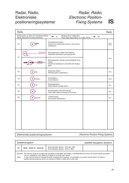
Radar, Radio,<br />
Elektroniske<br />
positioneringssystemer<br />
Radio Radio<br />
Radarmaster og -tårne som kendelige objekter<br />
Radar Structures Forming Landmarks<br />
10<br />
11<br />
12<br />
13<br />
14<br />
RD<br />
RD<br />
15 R<br />
Name<br />
RC<br />
RW<br />
RD≠269,5°<br />
Lts 270°<br />
RD 270°<br />
Consol<br />
RG<br />
16 Aero RC<br />
IE<br />
Meldepunkt for trafikkontrol<br />
Radio Reporting (Calling -in or Way) Points<br />
Rundstrålende radiofyr<br />
Circular (non-directional) marine or aeromarine<br />
radiobeacon<br />
Retningsbestemt radiofyr med ledelinie<br />
Directional radiobeacon with bearing line<br />
Retningsbestemt radiofyr sammenfaldende med<br />
ledefyr<br />
Directional radiobeacon coincident with leading<br />
lights<br />
Roterende radiofyr<br />
Rotating-pattern radiobeacon<br />
Consolstation<br />
Consol Beacon<br />
Radiopejlestation<br />
Radio direction-finding station<br />
Kystradiostation med QTG service<br />
Coast radio station providing QTG service<br />
Luftfartsradiofyr<br />
Aeronautical radiobeacon<br />
Radar, Radio,<br />
Electronic Position-<br />
Fixing Systems IS<br />
Elektroniske positioneringssystemer Electronic Position-Fixing Systems<br />
Satellitnavigation Satellite Navigation Systems<br />
50<br />
WGS WGS 72 WGS 84<br />
World Geodetic System. 1972 eller 1984<br />
World Geodetic System. 1972 or 1984<br />
Bemærk: En note kan vises for at angive den korrektion på længden og bredden, i hundrededele af et minut, der skal anvendes på positionen<br />
fra satellitterne (som refererer til WGS) for at bruge den i kortet.<br />
Note: A note may be shown to indicate the shifts of latitude and longitude, in hundredths of a minute, which should be made to<br />
satellite-derived positions (which are referred to WGS) to relate them to the chart.<br />
IM<br />
481,1<br />
480,1<br />
481,1<br />
481,1<br />
481,3<br />
483<br />
484<br />
482<br />
69