Kort 1 - Duelighed.dk
Kort 1 - Duelighed.dk
Kort 1 - Duelighed.dk
You also want an ePaper? Increase the reach of your titles
YUMPU automatically turns print PDFs into web optimized ePapers that Google loves.
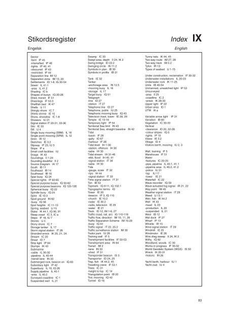
Stikordsregister Index IX<br />
Engelsk English<br />
Sector<br />
-faint IP 45<br />
-intensified IP 46<br />
-lights IP 40, 41<br />
-obscured IP 43<br />
-restricted IP 44<br />
Separation line IM 12<br />
Separation zone IM 13, 20<br />
Settlements ID 1-8, IG 50-54<br />
Sewer IL 41.1<br />
-area IL 41.2<br />
Shading IC b<br />
Shapes of buoys IQ 20-26<br />
Shed, transit IF 51<br />
Sheerlegs IF 53.3<br />
Shellfish bed IK 47<br />
Shells IJ 11<br />
Shingly shore IC 7<br />
Shinto shrine IE 15<br />
Shore, shoreline IC 1-8<br />
Showers IU 21<br />
Signal station IT 20-31, 33-36<br />
Silo IE 33<br />
Silt IJ 4<br />
Single buoy mooring (SBM) IL 16<br />
Single point mooring (SPM) IL 12<br />
Siren IR 12<br />
Sketches IE 3.2<br />
Slipway IF 23, IU 5<br />
Slope IF a<br />
Small craft facilities IU<br />
Snags IK 43<br />
Soundings II 1-24<br />
Sounding doubtful II 2<br />
Source Diagram IA 17<br />
South IB 11<br />
Southeast IB 14<br />
Southwest IB 16<br />
Spar buoy IQ 24<br />
Special lights IP 60-65<br />
Special purpose buoys IQ 50-62<br />
Special purpose beacons IQ 120-126<br />
Spherical buoy IQ 22<br />
Spindle buoy IQ 24<br />
Spire IE 10.3<br />
Spoil ground IN 62<br />
-buoy IQ 56<br />
Spot heights IC 11-13<br />
Spring, seabed IJ 15<br />
Stake IK 44.1, IQ 90, 91<br />
Steep coast IC 3, IC a<br />
Steps IF 18, IU 7<br />
Stones IJ 5<br />
Stony shore IC 7<br />
Storage tanker IL 17<br />
Storm signal station IT 28<br />
Stranded wreck IK 20, 21, 24<br />
Stream IC 20<br />
Street ID 7<br />
Strip light IP 64<br />
Stumps IK 43<br />
Submarine<br />
-cable IL 30-32<br />
-pipeline IL 40-44<br />
-transit lane IN 33<br />
Submerged rock, beacon on IQ 83<br />
Subsidiary light IP 42<br />
Superbuoy IL 16, IQ 26<br />
Supply pipeline IL 40.1<br />
-area IL 40.2<br />
Surveyed coastline IC 1<br />
Suspended well IL 21<br />
Swamp IC 33<br />
Swept area, depth II 24, IK 2<br />
Swing bridge ID 23.2<br />
Swinging circle IN 11.2<br />
Symbols in plan IB 30<br />
Symbols in profile IB 31<br />
Tank IE 32<br />
Tanker<br />
-anchorage area IN 12.5<br />
-mooring buoy IL 16<br />
-storage IL 17<br />
Target buoy IQ 51<br />
Telegraph<br />
-line ID 27<br />
-station IT 27<br />
Telephone line ID 27<br />
Telephone, public IU 25<br />
Telephonic mooring buoy IQ 43<br />
Television mast, tower IE 28, 29<br />
Temple IE 13-16<br />
Temporary light IP 54<br />
Territorial Sea limit IN 43<br />
Territorial Sea, straight baseline IN 42<br />
Tidal<br />
-basin IF 28<br />
-gully IO 67<br />
-harbour IF 28<br />
Tidal level IH 1-30<br />
-station, offshore IH 30<br />
-table IH 30<br />
Tidal stream IH 31-46<br />
-ebb, flood IH 40, 41<br />
-signal station IT 34<br />
-table IH 30<br />
Tide<br />
-gauge, scale IT 32<br />
-rips IH 44<br />
-signal station IT 33<br />
Time signal station IT 31<br />
Ton IB 53<br />
Topmark IQ 9-11, IQ 102.1<br />
Topographic terms IG<br />
Tower IE 20<br />
-beacon IP 3, IQ 110<br />
-church IE 10.2<br />
-radar IE 30.2<br />
-radio, television IE 29<br />
-water IE 21<br />
Track ID 12, IM 1-6, 27<br />
Traffic (road, rail, air) IG 110-118<br />
Traffic flow, direction IM 10, 11, 26<br />
Traffic Separation Scheme IM 10-29<br />
-buoy IQ 61<br />
Traffic signal IT 22, 25.2<br />
Traffic surveillance station IM 30<br />
Trailor park IU 28<br />
Training wall IF 5<br />
Transhipment facilities IF 50-53<br />
Transhipment area IN 64<br />
Transit IM 2<br />
-lane IN 33<br />
-shed IF 51<br />
Transponder beacon IS 3<br />
Transporter ID 24, 25<br />
Trap, fish IK 44.2, 45<br />
Travelling crane IF 53.1<br />
Trees IC 31<br />
-height to top IC 14<br />
Triangulation point IB 20<br />
Trot, mooring IQ 42<br />
Tunnel ID 16<br />
Tunny nets IK 44, 45<br />
Two-way route IM 27, 28<br />
Two-way track IM 5.2<br />
Tyfon IR 13<br />
Types of seabed IJ 1-15<br />
Under construction, reclamation IF 30-32<br />
Underwater installations IL 20-23<br />
Underwater rock IK 11-25<br />
Units IB 40-54<br />
Unmanned, unwatched light IP 53<br />
Unsurveyed<br />
-area II 25<br />
-coastline IC 2<br />
-wreck IK 28-30<br />
Upper light IP 22<br />
Urban area ID 1<br />
UTM IA a<br />
Variable arrow light IP 31<br />
Variation IB 60<br />
Vegetation IC 30-33<br />
Vertical<br />
-clearance ID 20, 22-28<br />
-colour stripes IQ 5<br />
-lights IP 15<br />
Views IE 3.2<br />
Village ID 4<br />
Visitors berth, mooring IU 2, 3<br />
Wall, training IF 5<br />
Warehouse IF 51<br />
Water<br />
-features IC 20-25<br />
-pipe, pipeline IL 40.1, 41.1<br />
-pipeline area IL 40.2, 41.2<br />
-police IU 31<br />
-tap IU 17<br />
-tower IE 21<br />
Waterfall IC 22<br />
Wave recorder IQ 59<br />
Wave-actuated fog signal IR 21, 22<br />
Way point IM 40<br />
Weather signal station IT 29<br />
Weed IJ 13.1<br />
Weir, fish IK 44.2<br />
Well IK 43<br />
-head IL 23<br />
-production IL 20<br />
-suspended IL 21<br />
West IB 12<br />
Wet dock IF 27<br />
Wharf IF 13<br />
Whistle IR 15<br />
Wind signal station IT 29<br />
Windmill IE 25<br />
Windmotor IE 26<br />
Wire drag sweep II 24, IK 2<br />
Withy IQ 92<br />
Woodland, woods IC 30<br />
Works in progress IF 30-32<br />
World Geodetic System (WGS) IS 50<br />
Wreck IK 20-31<br />
-historic IN 26<br />
Yacht berth, harbour IU 1<br />
Yacht club IU 4<br />
83


