
Create successful ePaper yourself
Turn your PDF publications into a flip-book with our unique Google optimized e-Paper software.
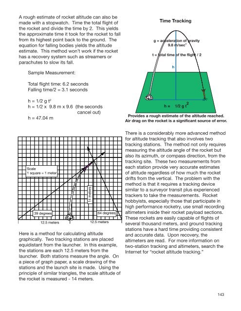
A rough estimate of <strong>rocket</strong> altitude can also be<br />
made with a stopwatch. Time the total flight of<br />
the <strong>rocket</strong> and divide the time by 2. This yields<br />
the approximate time it took for the <strong>rocket</strong> to fall<br />
from its highest point back to the ground. The<br />
equation for falling bodies yields the altitude<br />
estimate. This method won’t work if the <strong>rocket</strong><br />
has a recovery system such as streamers or<br />
parachutes to slow its fall.<br />
Sample Measurement:<br />
Total flight time: 6.2 seconds<br />
Falling time/2 = 3.1 seconds<br />
h = 1/2 g t 2<br />
h = 1/2 x 9.8 m x 9.6 (the seconds<br />
cancel out)<br />
h = 47.04 m<br />
Scale<br />
1 square = 1 meter<br />
39 degrees<br />
12.5 meters<br />
14 meters<br />
64 degrees<br />
12.5 meters<br />
Here is a method for calculating altitude<br />
graphically. Two tracking stations are placed<br />
equidistant from the launcher. In this example,<br />
the stations are each 12.5 meters from the<br />
launcher. Both stations measure the angle. On<br />
a piece of graph paper, a scale drawing of the<br />
stations and the launch site is made. Using the<br />
principle of similar triangles, the scale altitude of<br />
the <strong>rocket</strong> is measured - 14 meters.<br />
There is a considerably more advanced method<br />
for altitude tracking that also involves two<br />
tracking stations. The method not only requires<br />
measuring the altitude angle of the <strong>rocket</strong> but<br />
also its azimuth, or compass direction, from the<br />
tracking site. These two measurements from<br />
each station provide very accurate estimates<br />
of altitude regardless of how much the <strong>rocket</strong><br />
drifts from the vertical. The problem with the<br />
method is that it requires a tracking device<br />
similar to a surveyor transit plus experienced<br />
trackers to take the measurements. Rocket<br />
hobbyists, especially those that participate in<br />
high performance <strong>rocket</strong>ry, use small recording<br />
altimeters inside their <strong>rocket</strong> payload sections.<br />
These <strong>rocket</strong>s are easily capable of flights of<br />
several thousand meters, and ground tracking<br />
stations have a hard time providing consistent<br />
and accurate data. Upon recovery, the<br />
altimeters are read. For more information on<br />
two-station tracking and altimeters, search the<br />
Internet for “<strong>rocket</strong> altitude tracking.”<br />
143