
You also want an ePaper? Increase the reach of your titles
YUMPU automatically turns print PDFs into web optimized ePapers that Google loves.
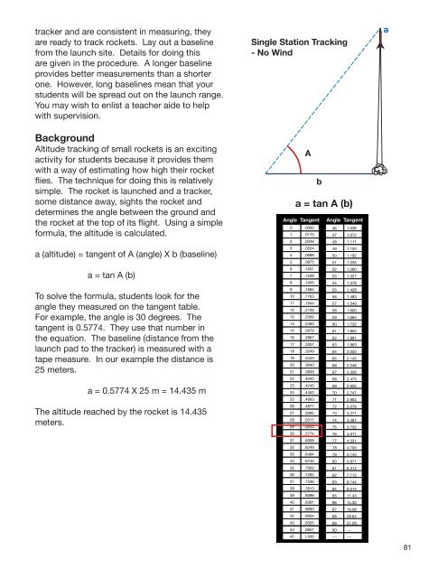
tracker and are consistent in measuring, they<br />
are ready to track <strong>rocket</strong>s. Lay out a baseline<br />
from the launch site. Details for doing this<br />
are given in the procedure. A longer baseline<br />
provides better measurements than a shorter<br />
one. However, long baselines mean that your<br />
students will be spread out on the launch range.<br />
You may wish to enlist a teacher aide to help<br />
with supervision.<br />
Background<br />
Altitude tracking of small <strong>rocket</strong>s is an exciting<br />
activity for students because it provides them<br />
with a way of estimating how high their <strong>rocket</strong><br />
flies. The technique for doing this is relatively<br />
simple. The <strong>rocket</strong> is launched and a tracker,<br />
some distance away, sights the <strong>rocket</strong> and<br />
determines the angle between the ground and<br />
the <strong>rocket</strong> at the top of its flight. Using a simple<br />
formula, the altitude is calculated.<br />
a (altitude) = tangent of A (angle) X b (baseline)<br />
a = tan A (b)<br />
To solve the formula, students look for the<br />
angle they measured on the tangent table.<br />
For example, the angle is 30 degrees. The<br />
tangent is 0.5774. They use that number in<br />
the equation. The baseline (distance from the<br />
launch pad to the tracker) is measured with a<br />
tape measure. In our example the distance is<br />
25 meters.<br />
a = 0.5774 X 25 m = 14.435 m<br />
The altitude reached by the <strong>rocket</strong> is 14.435<br />
meters.<br />
Single Station Tracking<br />
- No Wind<br />
81