Slauson Station - ULI Los Angeles - Urban Land Institute
Slauson Station - ULI Los Angeles - Urban Land Institute
Slauson Station - ULI Los Angeles - Urban Land Institute

You also want an ePaper? Increase the reach of your titles
YUMPU automatically turns print PDFs into web optimized ePapers that Google loves.
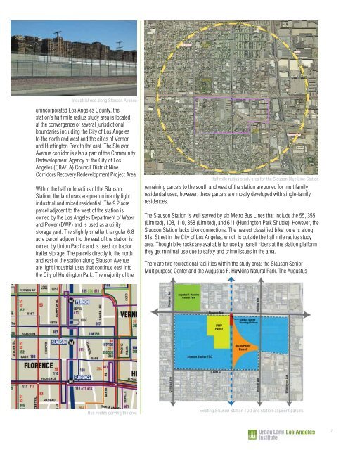
Industrial use along <strong>Slauson</strong> Avenue<br />
unincorporated <strong>Los</strong> <strong>Angeles</strong> County, the<br />
station’s half mile radius study area is located<br />
at the convergence of several jurisdictional<br />
boundaries including the City of <strong>Los</strong> <strong>Angeles</strong><br />
to the north and west and the cities of Vernon<br />
and Huntington Park to the east. The <strong>Slauson</strong><br />
Avenue corridor is also a part of the Community<br />
Redevelopment Agency of the City of <strong>Los</strong><br />
<strong>Angeles</strong> (CRA/LA) Council District Nine<br />
Corridors Recovery Redevelopment Project Area.<br />
Within the half mile radius of the <strong>Slauson</strong><br />
<strong>Station</strong>, the land uses are predominantly light<br />
industrial and mixed residential. The 9.2 acre<br />
parcel adjacent to the west of the station is<br />
owned by the <strong>Los</strong> <strong>Angeles</strong> Department of Water<br />
and Power (DWP) and is used as a utility<br />
storage yard. The slightly smaller triangular 6.8<br />
acre parcel adjacent to the east of the station is<br />
owned by Union Pacific and is used for tractor<br />
trailer storage. The parcels directly to the north<br />
and east of the station along <strong>Slauson</strong> Avenue<br />
are light industrial uses that continue east into<br />
the City of Huntington Park. The majority of the<br />
Bus routes serving the area<br />
52ND ST<br />
53RD ST<br />
63RD ST<br />
HOOPER<br />
AV<br />
HOOPER AV<br />
HOOPER AV<br />
LATHAM ST<br />
ASCOT AV<br />
58TH PL<br />
58TH DR<br />
59TH ST<br />
59TH PL<br />
60TH ST<br />
61ST ST<br />
62ND ST<br />
UP RR<br />
PARMELEE AV<br />
LOS ANGELES<br />
58TH ST<br />
BNSF RR<br />
SLAUSON AV<br />
GAGE AV<br />
64TH ST<br />
COMPTON AV<br />
COMPTON AV<br />
SLAUSON SENIOR<br />
MULTIPURPOSE<br />
CENTER<br />
54TH ST<br />
55TH ST<br />
56TH ST<br />
57TH ST<br />
AUGUSTUS HAWKINS<br />
NATURAL PARK<br />
MAKEE AV<br />
50TH ST<br />
51ST ST<br />
52ND ST<br />
53RD ST<br />
FORTUNA ST<br />
MIRAMONTE<br />
BLVD<br />
MORGAN AV<br />
50TH PL<br />
CONVERSE AV<br />
65TH ST<br />
remaining parcels to the south and west of the station are zoned for multifamily<br />
residential uses, however, these parcels are mostly developed with single-family<br />
residences.<br />
The <strong>Slauson</strong> <strong>Station</strong> is well served by six Metro Bus Lines that include the 55, 355<br />
(Limited), 108, 110, 358 (Limited), and 611 (Huntington Park Shuttle). However, the<br />
<strong>Slauson</strong> <strong>Station</strong> lacks bike connections. The nearest classified bike route is along<br />
51st Street in the City of <strong>Los</strong> <strong>Angeles</strong>, which is outside the half mile radius study<br />
area. Though bike racks are available for use by transit riders at the station platform<br />
they get minimal use due to safety and crime issues in the area.<br />
There are two recreational facilities within the study area: the <strong>Slauson</strong> Senior<br />
Multipurpose Center and the Augustus F. Hawkins Natural Park. The Augustus<br />
LONG BEACH AV<br />
SOUTH AV<br />
METRO BLUE LINE & UP RR<br />
METRO BLUE<br />
LINE &<br />
UP RR<br />
n¤<br />
LONG BEACH AV<br />
RANDOLPH ST<br />
METRO<br />
BLUE LINE &<br />
UP RR<br />
JUNCTION ST<br />
DUARTE ST<br />
STAUNTON AV<br />
HOLMES AV<br />
HOLMES AV<br />
Existing <strong>Slauson</strong> <strong>Station</strong> TOD and station-adjacent parcels<br />
nm<br />
60TH ST<br />
BANDERA ST<br />
58TH PL<br />
LILLIAN STREET<br />
ELEMENTARY<br />
SCHOOL<br />
61ST ST<br />
62ND ST<br />
63RD ST<br />
LILLIAN ST<br />
BNSF RR<br />
MCGARRY ST<br />
ALBA ST<br />
WILMINGTON AV<br />
ALAMEDA ST<br />
ALAMEDA ST<br />
UP RR<br />
GAGE AV<br />
64TH ST<br />
ALAMEDA ST<br />
UP RR<br />
1ST ST<br />
SLAUSON AV<br />
LAURA AV<br />
UP RR<br />
51ST ST<br />
BELGRAVE AV<br />
52ND ST<br />
VERNON<br />
RANDOLPH ST<br />
55TH ST<br />
57TH ST<br />
HUNTINGTON PARK<br />
REGENT ST<br />
REGENT ST<br />
2ND ST<br />
CLARENDON AV<br />
Half mile radius study area for the <strong>Slauson</strong> Blue Line <strong>Station</strong><br />
COTTAGE ST<br />
ANDERSON ST<br />
INGLEWOOD<br />
LADERA HEIGHTS / VIEWPARK -<br />
WINDSOR HILLS<br />
§¨¦ 405<br />
LOS<br />
ANGELES<br />
DEL<br />
AIRE<br />
REDONDO<br />
BEACH<br />
n¤<br />
nm<br />
LENNOX<br />
COUNTY OF LOS A<br />
TRANSIT-ORIENTED<br />
SLAUSON ST<br />
LEGEND<br />
HAWTHORNE<br />
LAWNDALE<br />
INGLEWOOD<br />
HAWTHORNE<br />
7<br />
SLAUSON STATION (ME<br />
ELEMENTARY SCHOOL<br />
PARCEL BOUNDARIES<br />
EXISTING TRANSIT-ORIE<br />
PROPOSED GENERAL P<br />
ZONING CODES (COUNTYWIDE)<br />
R-1 - SINGLE-FAMILY RESIDENCE<br />
R-2 - TWO-FAMILY RESIDENCE<br />
R-3-()U - LIMITED MULTIPLE RESIDENCE<br />
R-4-()U - UNLIMITED RESIDENCE<br />
R-A - RESIDENTIAL AGRICULTURE<br />
RPD - RESIDENTIAL PLANNED DEV.<br />
A-1 - LIGHT AGRICULTURE<br />
A-2 - HEAVY AGRICULTURE<br />
A-2-H - HEAVY AGRI. INCLU. HOG RANCHES<br />
C-H - COMMERCIAL HIGHWAY<br />
C-1 - RESTRICTED BUSINESS<br />
C-2 - NEIGHBORHOOD COMMERCIAL<br />
C-3 - UNLIMITED COMMERCIAL<br />
C-M - COMMERCIAL MANUFACTURING<br />
C-R - COMMERCIAL RECREATION<br />
CPD - COMMERCIAL PLANNED DEV.<br />
M-1 - LIGHT MANUFACTURING<br />
D-2 - DESERT-MOUNTAIN<br />
ALONDRA PARK<br />
§¨¦ 105<br />
HAWTHORNE<br />
ISLAND<br />
LOS ANGELES<br />
AREA<br />
MAPPED<br />
WEST ATHENS -<br />
WESTMONT<br />
GARDENA<br />
IT - INSTIT<br />
SP - SPEC<br />
M-1.5 - RE<br />
MPD - MA<br />
M-2 - HEA<br />
M-3 - UNC<br />
M-4 - UNL<br />
M-2.5 - AIR<br />
B-1 - BUF<br />
B-2 - COR<br />
R-R - RES<br />
W - WATE<br />
P-R - RES<br />
SR-D - SC<br />
O-S - OPE<br />
A-C - ART<br />
MXD - MIX<br />
PROPOSED LAND USE POLICY (CO<br />
CM - MAJOR COMMERCIAL<br />
CN - NEIGHBORHOOD COMMERCIAL<br />
H18 - MEDIUM DENSITY RES. (9-18 DU/AC)<br />
H30 - URBAN RESIDENTIAL (18-30 DU/AC)<br />
H50 - URBAN MEDIUM RES. (30-50 DU/AC)<br />
H9 - SUBURBAN HIGH DENSITY RES. (0-9 DU/AC) RL - RU<br />
IL - LIGHT INDUSTRIAL<br />
PROPOSED GENER<br />
TOD OVERL<br />
FLORENCE-FIRE<br />
OS-BLM - BUREAU OF LAND MANAGEMENT<br />
4-INCH RESOLUTION IMAGERY: LOS ANGELES REGION<br />
IMAGERY ACQUISITION CONSORTIUM, 2008<br />
OS-C - O<br />
OS-MR -<br />
OS-PR -<br />
OS-W - W<br />
P - PUB<br />
TC - TRA<br />
VERMONT<br />
Map prepared by DRP GIS Section / August 2010<br />
§¨¦ 110<br />
LOS ANGELES COUN<br />
Department of Regional Pl<br />
320 W. Temple St.<br />
<strong>Los</strong> <strong>Angeles</strong>, CA 9001<br />
0 150 300 450<br />
FEET<br />
\\Gisps1\PROJECTS_GISPS1\DRP_ADVANCE_PLANNING\general_plan\map_documents\tod\<strong>ULI</strong>_applicatio<br />
W