UHF2 realignment study - Ofcom Licensing
UHF2 realignment study - Ofcom Licensing
UHF2 realignment study - Ofcom Licensing

Create successful ePaper yourself
Turn your PDF publications into a flip-book with our unique Google optimized e-Paper software.
Figure 5 Wide Area PBR<br />
240689 - 450-470 Study Final Print<br />
Version (Dec08).doc<br />
Figure 6 National and<br />
Regional PBR<br />
Page 23<br />
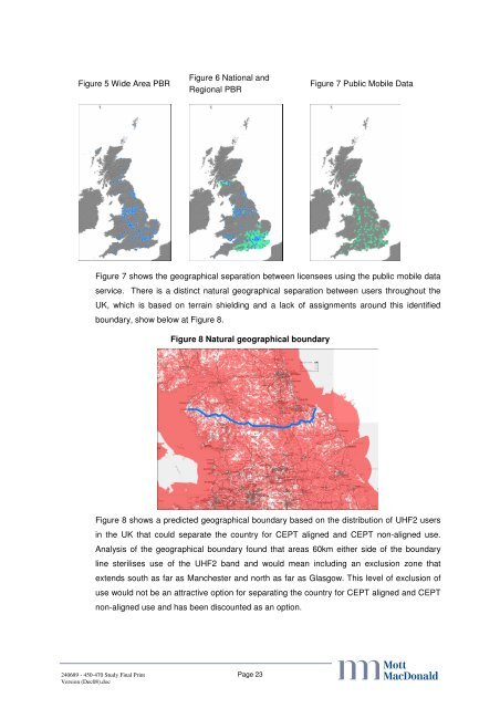
Figure 7 Public Mobile Data<br />
Figure 7 shows the geographical separation between licensees using the public mobile data<br />
service. There is a distinct natural geographical separation between users throughout the<br />
UK, which is based on terrain shielding and a lack of assignments around this identified<br />
boundary, show below at Figure 8.<br />
Figure 8 Natural geographical boundary<br />
Figure 8 shows a predicted geographical boundary based on the distribution of <strong>UHF2</strong> users<br />
in the UK that could separate the country for CEPT aligned and CEPT non-aligned use.<br />
Analysis of the geographical boundary found that areas 60km either side of the boundary<br />
line sterilises use of the <strong>UHF2</strong> band and would mean including an exclusion zone that<br />
extends south as far as Manchester and north as far as Glasgow. This level of exclusion of<br />
use would not be an attractive option for separating the country for CEPT aligned and CEPT<br />
non-aligned use and has been discounted as an option.<br />
abc