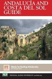
CRETE TRAVEL GUIDE
CRETE TRAVEL GUIDE
CRETE TRAVEL GUIDE

You also want an ePaper? Increase the reach of your titles
YUMPU automatically turns print PDFs into web optimized ePapers that Google loves.
Crete Travel Guide<br />
and protected, and the beach becomes overrun with<br />
visitors in high season. Nevertheless, it is beautiful,<br />
especially if visited outside the busiest summer months<br />
of June, July and August.<br />
➤ Map R4<br />
Zakros Gorge<br />
The Zakros Gorge is<br />
known locally as the Valley<br />
of the Dead because the<br />
numerous caves in its<br />
limestone walls were used<br />
as tombs in Roman times.<br />
The gorge runs from the<br />
peaceful village of Ano (“upper”) Zakros to Kato (“lower”)<br />
Zakros on the sea, near an ancient Minoan palace site<br />
rediscovered in 1961. It is a beautiful and not too<br />
challenging 8-km (5-mile) hike (see Zakros Gorge).<br />
Taverna, Kato Zakros<br />
➤ Map Q5<br />
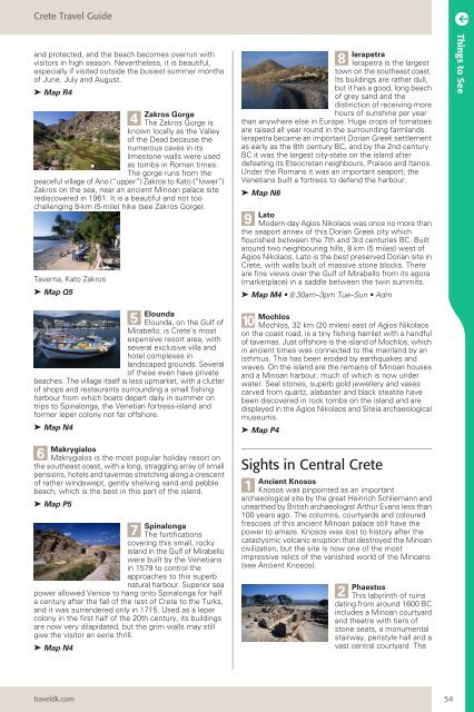
5 Elounda<br />
Elounda, on the Gulf of<br />
Mirabello, is Crete’s most<br />
expensive resort area, with<br />
several exclusive villa and<br />
hotel complexes in<br />
landscaped grounds. Several<br />
of these even have private<br />
beaches. The village itself is less upmarket, with a clutter<br />
of shops and restaurants surrounding a small fishing<br />
harbour from which boats depart daily in summer on<br />
trips to Spinalonga, the Venetian fortress-island and<br />
former leper colony not far offshore.<br />
➤ Map N4<br />
6 Makrygialos is the most popular holiday resort on<br />
the southeast coast, with a long, straggling array of small<br />
pensions, hotels and tavernas stretching along a crescent<br />
of rather windswept, gently shelving sand and pebble<br />
beach, which is the best in this part of the island.<br />
➤ Map P5<br />
7 Spinalonga<br />
The fortifications<br />
covering this small, rocky<br />
island in the Gulf of Mirabello<br />
were built by the Venetians<br />
in 1579 to control the<br />
approaches to this superb<br />
natural harbour. Superior sea<br />
power allowed Venice to hang onto Spinalonga for half<br />
a century after the fall of the rest of Crete to the Turks,<br />
and it was surrendered only in 1715. Used as a leper<br />
colony in the first half of the 20th century, its buildings<br />
are now very dilapidated, but the grim walls may still<br />
give the visitor an eerie thrill.<br />
➤ Map N4<br />
traveldk.com<br />
4<br />
8 Ierapetra<br />
Ierapetra is the largest<br />
town on the southeast coast.<br />
Its buildings are rather dull,<br />
but it has a good, long beach<br />
of grey sand and the<br />
distinction of receiving more<br />
hours of sunshine per year<br />
than anywhere else in Europe. Huge crops of tomatoes<br />
are raised all year round in the surrounding farmlands.<br />
Ierapetra became an important Dorian Greek settlement<br />
as early as the 8th century BC, and by the 2nd century<br />
BC it was the largest city-state on the island after<br />
defeating its Eteocretan neighbours, Praisos and Itanos.<br />
Under the Romans it was an important seaport; the<br />
Venetians built a fortress to defend the harbour.<br />
➤ Map N6<br />
9 Lato<br />
Modern-day Agios Nikolaos was once no more than<br />
the seaport annex of this Dorian Greek city which<br />
flourished between the 7th and 3rd centuries BC. Built<br />
around two neighbouring hills, 8 km (5 miles) west of<br />
Agios Nikolaos, Lato is the best preserved Dorian site in<br />
Crete, with walls built of massive stone blocks. There<br />
are fine views over the Gulf of Mirabello from its agora<br />
(marketplace) in a saddle between the twin summits.<br />
➤ Map M4 • 8:30am–3pm Tue–Sun • Adm<br />
10 Mochlos<br />
Mochlos, 32 km (20 miles) east of Agios Nikolaos<br />
on the coast road, is a tiny fishing hamlet with a handful<br />
of tavernas. Just offshore is the island of Mochlos, which<br />
in ancient times was connected to the mainland by an<br />
isthmus. This has been eroded by earthquakes and<br />
waves. On the island are the remains of Minoan houses<br />
and a Minoan harbour, much of which is now under<br />
water. Seal stones, superb gold jewellery and vases<br />
carved from quartz, alabaster and black steatite have<br />
been discovered in rock tombs on the island and are<br />
displayed in the Agios Nikolaos and Siteia archaeological<br />
museums.<br />
➤ Map P4<br />
Sights in Central Crete<br />
1<br />
Ancient Knosos<br />
Knosos was pinpointed as an important<br />
archaeological site by the great Heinrich Schliemann and<br />
unearthed by British archaeologist Arthur Evans less than<br />
100 years ago. The columns, courtyards and coloured<br />
frescoes of this ancient Minoan palace still have the<br />
power to amaze. Knosos was lost to history after the<br />
cataclysmic volcanic eruption that destroyed the Minoan<br />
civilization, but the site is now one of the most<br />
impressive relics of the vanished world of the Minoans<br />
(see Ancient Knosos).<br />
2 Phaestos<br />
This labyrinth of ruins<br />
dating from around 1600 BC<br />
includes a Minoan courtyard<br />
and theatre with tiers of<br />
stone seats, a monumental<br />
stairway, peristyle hall and a<br />
vast central courtyard. The<br />
54<br />
Things to See