Great Falls Montana: Its Situation, Surroundings - Montana Historical ...
Great Falls Montana: Its Situation, Surroundings - Montana Historical ...
Great Falls Montana: Its Situation, Surroundings - Montana Historical ...

You also want an ePaper? Increase the reach of your titles
YUMPU automatically turns print PDFs into web optimized ePapers that Google loves.
Saint Marie: <strong>Montana</strong>’s<br />
Newest Ghost Town<br />
A few miles north of U.S. Highway 2, on<br />
<strong>Montana</strong> Highway 24, lies <strong>Montana</strong>’s most<br />
modern ghost town. The little community of<br />
Saint Marie was built in the 1950s to house the<br />
airmen at Glasgow Air Force Base and their<br />
families. About 7,200 people lived here, but<br />
when the air base shut down, Saint Marie<br />
became a ghost town. Today, hundreds of<br />
1960s-vintage homes—complete with hardwood<br />
floors and swing sets—line the empty<br />
streets. Fewer than 200 people live here.<br />
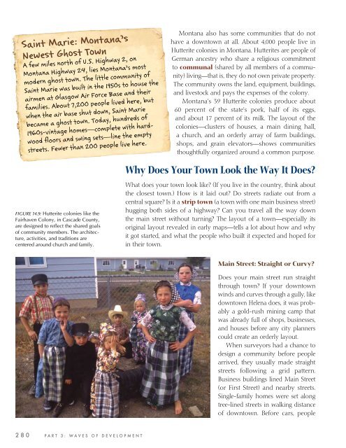
FIGURE 14.9: Hutterite colonies like the<br />
Fairhaven Colony, in Cascade County,<br />
are designed to refl ect the shared goals<br />
of community members. The architecture,<br />
activities, and traditions are<br />
centered around church and family.<br />
2 8 0 P A R T 3 : W A V E S O F D E V E L O P M E N T<br />
<strong>Montana</strong> also has some communities that do not<br />
have a downtown at all. About 4,000 people live in<br />
Hutterite colonies in <strong>Montana</strong>. Hutterites are people of<br />
German ancestry who share a religious commitment<br />
to communal (shared by all members of a community)<br />
living—that is, they do not own private property.<br />
The community owns the land, equipment, buildings,<br />
and livestock and pays the expenses of the colony.<br />
<strong>Montana</strong>’s 39 Hutterite colonies produce about<br />
60 percent of the state’s pork, half of its eggs,<br />
and about 17 percent of its milk. The layout of the<br />
colonies—clusters of houses, a main dining hall,<br />
a church, and an orderly array of farm buildings,<br />
shops, and grain elevators—shows communities<br />
thoughtfully organized around a common purpose.<br />
Why Does Your Town Look the Way It Does?<br />
What does your town look like? (If you live in the country, think about<br />
the closest town.) How is it laid out? Do streets radiate out from a<br />
central square? Is it a strip town (a town with one main business street)<br />
hugging both sides of a highway? Can you travel all the way down<br />
the main street without turning? The layout of a town—especially its<br />
original layout revealed in early maps—tells a lot about how and why<br />
it got started, and what the people who built it expected and hoped for<br />
in their town.<br />
Main Street: Straight or Curvy?<br />
Does your main street run straight<br />
through town? If your downtown<br />
winds and curves through a gully, like<br />
downtown Helena does, it was probably<br />
a gold-rush mining camp that<br />
was already full of shops, businesses,<br />
and houses before any city planners<br />
could create an orderly layout.<br />
When surveyors had a chance to<br />
design a community before people<br />
arrived, they usually made straight<br />
streets following a grid pattern.<br />
Business buildings lined Main Street<br />
(or First Street) and nearby streets.<br />
Single-family homes were set along<br />
tree-lined streets in walking distance<br />
of downtown. Before cars, people