- Page 2 and 3: Disclaimer: TNUIFSL City Corporate
- Page 4 and 5: T N U D P I III Final Report II TNU
- Page 6 and 7: T N U D P I III Final Report IV Lis
- Page 8 and 9: T N U D P I III Final Report VI TNU
- Page 10 and 11: T N U D P I III Final Report VIII L
- Page 12 and 13: T N U D P I III Final Report X Acro
- Page 14 and 15: 1 PROJECT PROJECT PROJECT BACKGROUN
- Page 16 and 17: TNUIFSL City Corporate cum Business
- Page 18 and 19: ANALYSING GROWTH DIRECTIONS Ecology
- Page 20 and 21: 1.2.2 Interim Stage 1.2.2.1 Strateg
- Page 22 and 23: TNUIFSL City Corporate cum Business
- Page 24 and 25: TNUIFSL City Corporate cum Business
- Page 26: TNUIFSL City Corporate cum Business
- Page 29 and 30: T N U D P I III Final Report 2-2 TN
- Page 31 and 32: T N U D P I III Final 2.3.2 Gender
- Page 34 and 35: TNUIFSL City Corporate cum Business
- Page 38 and 39: 4 ECONOMIC ECONOMIC DEVELOPMENT DEV
- Page 40 and 41: TNUIFSL City Corporate cum Business
- Page 42 and 43: T N U D P I III Final Report 5-2 TN
- Page 44 and 45: T N U D P I III Final Report 5-4 TN
- Page 46 and 47: T N U D P I III Final Report 5-6 TN
- Page 48 and 49: T N U D P I III Final Report 5-8 TN
- Page 50 and 51: T N U D P I III Final Report 5-10 5
- Page 52 and 53: T N U D P I III Final Report 5-12 5
- Page 54 and 55: T N U D P I III Final Report 6-2 6.
- Page 56 and 57: T N U D P I III Final Report 6-4 6.
- Page 58 and 59: T N U D P I III Final Report 7-2 TN
- Page 60 and 61: 8 FINANC FINANCIAL FINANC IAL STATU
- Page 62 and 63: TNUIFSL City Corporate cum Business
- Page 64 and 65: 8.3 Analysis of Income TNUIFSL City
- Page 66 and 67: TNUIFSL City Corporate cum Business
- Page 68 and 69: TNUIFSL City Corporate cum Business
- Page 70 and 71: TNUIFSL City Corporate cum Business
- Page 72 and 73: TNUIFSL Our Observations City Corpo
- Page 74 and 75: 8.8 Financials Consolidated TNUIFSL
- Page 76 and 77: 8.9 Demand, Collection and Balance
- Page 78: TNUIFSL City Corporate cum Business
- Page 81 and 82: T N U D P I III Final Report 9-2 o
- Page 83 and 84: 10 10 10 DEMAND DEMAND ASSESSMENT A
- Page 85: Particulars TNUIFSL City Corporate
- Page 88 and 89:
T N U D P I III Final Report 11-2 T
- Page 90 and 91:
T N U D P I III Final Report 11-4 S
- Page 92 and 93:
T N U D P I III Final Report 11-6 C
- Page 94 and 95:
T N U D P I III Final Report 11-8 1
- Page 96 and 97:
T N U D P I III Final Report 11-10
- Page 99:
12 12 12 S S W W O O TT T TNUIFSL C
- Page 102 and 103:
T N U D P I III Final Report 13-2 S
- Page 104 and 105:
T N U D P I III Final Report 14-2 T
- Page 107 and 108:
City Corporate cum Business Plan fo
- Page 109 and 110:
City Corporate cum Business Plan fo
- Page 111 and 112:
City Corporate cum Business Plan fo
- Page 113 and 114:
City Corporate cum Business Plan fo
- Page 115 and 116:
City Corporate cum Business Plan fo
- Page 117 and 118:
City Corporate cum Business Plan fo
- Page 119 and 120:
City Corporate cum Business Plan fo
- Page 121 and 122:
City Corporate cum Business Plan fo
- Page 123 and 124:
City Corporate cum Business Plan fo
- Page 125:
City Corporate cum Business Plan fo
- Page 128 and 129:
CHAPTER 16 : RISK ANALYSIS OF IDENT
- Page 130 and 131:
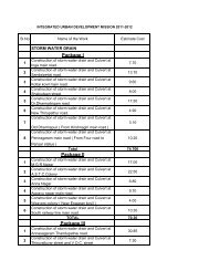
Project list Relaying new roads aft
- Page 132 and 133:
17 17 17 ASSET ASSET MANAGEMENT MAN
- Page 134 and 135:
Community Hall Nil Ulzhlavar Santhe
- Page 136 and 137:
Shops/Comm ercial Complex Slaughter
- Page 138 and 139:
TNUIFSL City Corporate cum Business
- Page 140 and 141:
17.2.2.2 O & M for proposed capital
- Page 142 and 143:
Table 17 E O & M for proposed capit
- Page 144 and 145:
17.3.3 Sustainability TNUIFSL City
- Page 146 and 147:
18 18 18 REFORMS REFORMS AND AND RE
- Page 148 and 149:
TNUIFSL City Corporate cum Business
- Page 150 and 151:
o Through banks o Through online pa
- Page 152 and 153:
18.2.2 Institutional Reforms TNUIFS
- Page 154 and 155:
18.2.2.2 Private Sector Participati
- Page 156 and 157:
TNUIFSL Table 18-F: E-Governance st
- Page 158 and 159:
Sewerage services Solid Waste Manag
- Page 160 and 161:
Street lights Roads TNUIFSL City Co
- Page 162:
TNUIFSL City Corporate cum Business
- Page 165 and 166:
T N U D P I III Final Report 19-2 T
- Page 167 and 168:
T N U D P I III Final Report 19-4 T
- Page 169 and 170:
T N U D P I III Final Report 19-6 1
- Page 171 and 172:
T N U D P I III Final Report 19-8 N
- Page 173 and 174:
T N U D P I III Final Report 19-10
- Page 175 and 176:
T N U D P I III Final Report 19-12
- Page 177 and 178:
TNUIFSL City Corporate cum Business
- Page 179 and 180:
Dharapuram Table No 19 J. : Financi
- Page 181 and 182:
TNUIFSL City Corporate cum Business
- Page 183 and 184:
Dharapuram Table No 19 L: Full Proj
- Page 185 and 186:
Table No 19 N : Calculation of Debt
- Page 187 and 188:
Dharapuram Table No 19 Q : Financia
- Page 189 and 190:
TNUIFSL City Corporate cum Business
- Page 191 and 192:
The following are the outcome under
- Page 193 and 194:
Dharapuram Table 19 V -Full Project
- Page 195 and 196:
Table No 19 X : Calculation of Debt
- Page 197 and 198:
Closing Balance (A+D)=E 0.00 -6.80
- Page 199 and 200:
Table No 19 AA : Calculation of Deb
- Page 201 and 202:
T N U D P I III Final Report 19-22
- Page 203 and 204:
T N U D P I III Final Report 19-24
- Page 205 and 206:
Reforms One time payment options fo
- Page 207 and 208:
Reforms Periodic Training to Public
- Page 209 and 210:
Particulars Current Status Assistan
- Page 211:
Particulars Current Status Assistan