ULTIMA THULE” - Kunstantikvariat Pama AS
ULTIMA THULE” - Kunstantikvariat Pama AS
ULTIMA THULE” - Kunstantikvariat Pama AS

You also want an ePaper? Increase the reach of your titles
YUMPU automatically turns print PDFs into web optimized ePapers that Google loves.
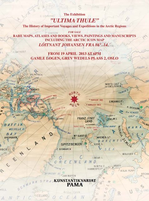
The Exhibition<br />
”<strong>ULTIMA</strong> <strong>THULE”</strong><br />
The History of Important Voyages and Expeditions in the Arctic Regions<br />
FOR SALE<br />
RARE MAPS, ATL<strong>AS</strong>ES AND BOOKS, VIEWS, PAINTINGS AND MANUSCRIPTS<br />
INCLUDING THE ARCTIC ICON MAP<br />
LÓITNANT JOHANSEN FRA 86°. 14.´<br />
FROM 19 APRIL 2013 AT 6PM<br />
GAMLE LOGEN, GREV WEDELS PL<strong>AS</strong>S 2, OSLO
«But the spirit of mankind will never rest till every spot<br />
of these regions has been trodden by the foot of man,<br />
till every enigma has been solved.»<br />
(Fridtjof Nansen, Farthest North vol I, page 3)<br />
Detail of catalogue number 134<br />
The manuscript map Lóitnant Johansen fra 86°. 14’<br />
which accompanied Hjalmar Johansen and Fridtjof<br />
Nansen on their sledge journey during<br />
the Fram Expedition
4<br />
www.antiquemaps.no<br />
The Exhibition<br />
«<strong>ULTIMA</strong> THULE»<br />
The History of Important Voyages and Expeditions in the Arctic Regions<br />
FOR SALE<br />
RARE MAPS, VIEWS, ATL<strong>AS</strong>ES AND BOOKS,<br />
PAINTINGS AND MANUSCRIPTS<br />
INCLUDING THE POLAR ICON MAP<br />
LÓITNANT JOHANSEN FRA 86°. 14.´<br />
The material will cover:<br />
The Explorations in the Barents Sea, The White Sea with Russia, and the North Pole area,<br />
mostly based on the historical search for a Northeast Passage.<br />
Topographical views from Northern Norway including rare «Lapponica».<br />
Decorative Maritime Art.<br />
THE OPENING RECEPTION IS 19 APRIL 2013 AT 6PM<br />
IN GAMLE LOGEN’S MAIN AUDITORIUM, GREV WEDELS PL<strong>AS</strong>S 2, OSLO<br />
FROM SATURDAY APRIL 20 – SUNDAY MAY 5 2013<br />
At the premises of Grev Wedels Plass Kunsthandel, Gamle Logen<br />
Monday – Friday 10 – 18, Saturday and Sunday 12 - 16<br />
KUNSTANTIKVARIAT PAMA <strong>AS</strong><br />
Tel. (+47) 22 44 06 00<br />
E-mail: post@antiquemaps.no<br />
www.antiquemaps.no<br />
GREV WEDELS PL<strong>AS</strong>S KUNSTHANDEL <strong>AS</strong><br />
Tel. (+47) 22 86 21 86<br />
E-mail: post@gwpa.no<br />
www.gwpa.no
INDEX<br />
FOREWORD ..............................................................................................................................................page 7<br />
A SHORT ATTEMPT TO EXPLAIN «<strong>ULTIMA</strong> THULE» .......................................................................page 8<br />
SOME OF THE PRINCIPAL VOYAGES AND EXPEDITIONS TO THE ARCTIC<br />
REGIONS AND THE NORTHE<strong>AS</strong>T P<strong>AS</strong>SAGE IN RELEVANCE TO THE<br />
CATALOGUE «<strong>ULTIMA</strong> THULE» ......................................................................................................page 9<br />
ELISABETH ISAKSSON «ARCTIC CLIMATE – CAN THE P<strong>AS</strong>T PREDICT<br />
THE FUTURE?» .................................................................................................................................page 10<br />
RARE AND IMPORTANT BOOKS RELATED TO THE NORTH ........................................................page 17<br />
RARE AND IMPORTANT MAPS OF THE ARCTIC AND THE NORTHERN REGION<br />
1482 – 1959 INCLUDING THE LARGE-SIZE MANUSCRIPT POLAR MAP FORMERLY<br />
IN THE COLLECTION OF R S G S – EDINBURGH ......................................................................page 41<br />
FRIDTJOF NANSEN & ROALD AMUNDSEN INCLUDING THE POLAR<br />
ICON MAP LÓITNANT JOHANSEN 86°. 14.´ ................................................................................ page 117<br />
KIRA MOSS «DRIFTING TOWARDS THE POLE»........................................................................... page 118<br />
A UNIQUE COLLECTION OF PLATE AND COLOUR PLATE BOOKS OF LAPLAND ................page 138<br />
ANN FALAHAT «FROM DOCUMENTATION TO F<strong>AS</strong>CINATION» ................................................page 139<br />
TOPOGRAPHICAL VIEWS AND COSTUME PLATES RELATED TO NORWAY<br />
AND LAPLAND .............................................................................................................................page 156<br />
DECORATIVE MARITIME ART ..........................................................................................................page 177<br />
TERMS AND EXPLANATIONS<br />
All items have been carefully described and are guaranteed to be genuine and authentic.<br />
The prices are in NOK (Norwegian kroner) all taxes included. As an indication only, the items are also priced in EURO<br />
after an approximate exchange rate of 1€ = NOK 7,50.<br />
Contemporary hand-coloured: In our opinion, the colouring is approximately contemporary with the date of issue.<br />
Hand-coloured: In our opinion, the colouring or parts of the colouring originates from a later period than the date of issue.<br />
The expression “state” in English = In Norwegian: “De forskjellige stadier i bearbeidelsen<br />
av en kobberplate, treblokk eller litografisk sten“.<br />
All sales of art are subject to the Artist resale law of 5%<br />
PLE<strong>AS</strong>E NOTE:<br />
THE CATALOGUE IS PUBLISHED SOME DAYS BEFORE THE OPENING<br />
OF THE EXHIBITION. IT IS THEREFORE POSSIBLE TO MAKE ORDERS FROM<br />
THE CATALOGUE BEFORE FRIDAY APRIL, 19th, 2013<br />
FOREWORD<br />
We have just finished a long winter. Those of us living in the Northern Hemisphere are looking forward to a prosperous<br />
spring with longer daylight hours and warmer days. Is this the right time to present a catalogue and exhibition of the<br />
Arctic Regions and the Ultima Thule?<br />
I choose to say it is perfect timing for a project like this. Certainly is the Polar Regions are known for the cold, dark nights<br />
and days and lot of ice and icebergs too, but we should not forget the fact that during the summer the sun never settles that<br />
far north. Over a short period of time life and nature in the region are going through rapid changes. We are able to observe<br />
a spectacular environment unlike most other places in the world. The serious climate changes in the Arctic are one of the<br />
main topics in today’s international debates and discussions.<br />
The early expeditions and explorers had to utilize the short summer in their attempt to conquer the Arctic Regions. But<br />
travelling was not easy and it took a long time before modern technology was available. Some of the pioneers were<br />
forced to spend the winter in the Arctic. Perhaps the winter camp was a part of the plan, or it was unexpected to remain<br />
up in the frozen world during a long and unmerciful winter. Fridtjof Nansen is an example of the first, Willem Barents<br />
of the second. Nansen survived, Barents unfortunately did not. These two world famous super-star explorers are the<br />
centre of this exhibition. The idea of a big Polar project was born almost 18 months ago when I was contacted by the<br />
descendent of the original owner of the manuscript map which accompanied Fridtjof Nansen and Hjalmar Johansen on<br />
the sledge journey towards the North Pole. To be in closer touch with the Polar and the Pioneer atmosphere is probably<br />
unachievable.<br />
The name of the exhibition and the catalogue, «Ultima Thule» is inspired by the title of one of several impressive<br />
cartography and travel books published by the Nurminen Foundation in Helsinki (this book published in 2001). I was<br />
given the opportunity to meet Juha Nurminen and his qualified staff a couple of years ago. How they combine maps and<br />
map collecting of the Arctic regions with their invaluable support to the improvement of the environment of the Baltic is<br />
an example to follow. As the quote says on page 51 in the catalogue «Northward Bound – At the Far edge of the World»<br />
Nordkappmuseet 2010: «Old maps are a gateway into a vast emotional, cultural, intellectual and historic universe».<br />
We hope to see you at the opening reception in Gamle Logen, Store Sal and the next two weeks in the rooms of Grev<br />
Wedels Plass Kunsthandel.<br />
6 www.antiquemaps.no <strong>Kunstantikvariat</strong> PAMA<br />
7<br />
Pål Sagen<br />
Bygdøy Allé 10, 0262 OSLO, Norway • Tlf: (+ 47) 22 44 06 00 • Fax: (+47) 22 44 06 01<br />
E-mail: post@antiquemaps.no • Internet: www.antiquemaps.no<br />
Specialist in antique maps and prints, topographical views, illustrated books and Norwegian 19th Century paintings.
A SHORT ATTEMPT TO EXPLAIN «<strong>ULTIMA</strong> THULE»<br />
We are grateful for being allowed to use the following text taken from, «Northward Bound at the Far Edge of the World»,<br />
Benedicte Gamborg Briså. Finnmark 2010:<br />
Thule is an island mentioned in Pytheas of Massilia’s now lost travel account entitled «On the Ocean» from c. 330 BC.<br />
Pytheas travelled in western and northern Europe and it is likely that he visited England, Ireland and northern Germany<br />
and a country that he called Thule. It is not known for sure exactly where the Thule that Pytheas described is located, but<br />
there have been a number of suggestions. The name has been placed in different locations in the northern regions, and<br />
today the American Air Force has an air base named Thule in Qaanaaq, in northwest Greenland. The term Ultima Thule<br />
now means the extreme or furthest north.<br />
Some scholars seem to claim that they know which island Pytheas refers to as Thule, but it is generally used as explained<br />
above. On the printed world maps based on Claudio Ptolemy’s «Geographia» prior to the first map of the Northern<br />
Region in 1482, «Scandia» and «Thule» are both being used to describe Scandinavia or the then outermost part of the<br />
known world. The same usage is consistent on both «Prima Europe Tabula» (Great Britain) and «Quarta Europe Tabula»<br />
(Denmark and Germany). Later on maps «Thule» or «Tile» is sometimes being used randomly in the Arctic region and<br />
the Atlantic Ocean, often referred to as Iceland. It has even on some maps showed up in the region of Telemark in South<br />
Norway!<br />
In the catalogue we often refer to the Arctic region which is defined as the area north of the Arctic Circle.<br />
(Ref:, Benedicte Gamborg Briså «Northward Bound at the Far edge of the World» Nordkappmuseet 2010, W.B. Ginsberg “Printed Maps of<br />
Scandinavia and the Arctic 1482 - 1601” Page 1 - 13, Lainema – Nurminen «UltimaThule – Arktiska Upptäcktsfärder»)<br />
SOME OF THE PRINCIPAL VOYAGES AND EXPEDITIONS<br />
TO THE ARCTIC REGIONS AND THE NORTHE<strong>AS</strong>T P<strong>AS</strong>SAGE<br />
WITH RELEVANCE TO THE CATALOGUE «<strong>ULTIMA</strong> THULE»<br />
The Ancient Time – c. 330 BC: Pytheas of Massilia travelled in western and northern<br />
Europe and it is likely that he visited England, Ireland and northern Germany and a country that he called Thule.<br />
1496: Gregory Istoma together with «gesandten» David from the King of Denmark sailed from the White Sea to<br />
Trondheim exploring the Murmansk Coast and Northern Norway<br />
1553: Richard Chancellor’s English expeditions searching for the Northeast Passage<br />
1594 – 97: Willem Barents’ three voyages to the Arctic searching for the Northeast Passage<br />
1607: Henry Hudson’s voyage and the exploration of Spitsbergen<br />
1610: The English explorer Jonas Poole sailing along the west coast of Spitsbergen initiating the English whaling trade in<br />
the Arctic<br />
Around 1613: Several English, French, Spanish and Dutch whaling expeditions to Spitsbergen<br />
1614: Dutch and French expeditions discover Jan Mayen<br />
1707: The Dutch explorer Cornelis Giles and his voyage to East Spitsbergen<br />
1733 – 43: Great Northern Expedition. The second Kamchatka expedition from Ob River to Lena River<br />
1827: First Norwegian Arctic expedition, led by B.M. Keilhau<br />
1838 – 40: «La Recherche». French expeditions to Scandinavia and the Arctic regions 1838 – 40 lead by Doctor Paul<br />
Gaimard<br />
1845: Sir John Franklin, and his lost expedition in the search for the Northwest Passage<br />
1872 – 74: Austria – Hungarian North Pole Expedition<br />
1878 – 79: Adolf Erik Nordensköld: «Vega» and the Swedish expedition<br />
1893 – 96: Fridthjof Nansen and The Fram expedition including Nansen and Hjalmar Johansen’s attempt to reach the<br />
North Pole on their own<br />
1896 – 97: William Martin Conway explored the interior of Spitsbergen<br />
1898 – 1902: The second Fram expedition led by Otto Sverdrup<br />
1903 – 06: Roald Amundsen’s expedition «Gjøa» penetrating the Northwest Passage for the first time<br />
1925: Flying boat expedition led by Roald Amundsen and Lincoln Ellsworth<br />
1926: Roald Amundsen, Umberto Nobile, and Lincoln Ellsworth’s airship «Norge» to the North Pole<br />
8 www.antiquemaps.no <strong>Kunstantikvariat</strong> PAMA<br />
9
The exhibition «Ultima Thule» presents most important maps of the Arctic from the first printed map of the region and<br />
the first world map to include Scandinavia and the North in 1482 until c. 1900. The earliest maps were still influenced<br />
by medieval ideas, sources and material and not always drawn accurately based on voyages or explorations. Through the<br />
history of centuries and thousands and millions of years the weather and climate condition in the Arctic has always been<br />
moving forth and back. Some of the old printed maps and early travel accounts can definetly give us some ideas of the<br />
current climate status in the Polar region and the ice situation. But if we are searching a more specific and reliable source<br />
of knowledge we better ask a scientist in the field.<br />
We want to express our thanks to Elisabeth Isaksson who has been most willing to write an article in the catalogue about<br />
the changing Arctic climate in a historical context.<br />
ARCTIC CLIMATE – CAN THE P<strong>AS</strong>T PREDICT THE FUTURE?<br />
Elisabeth Isaksson, Ph D senior scientist, glaciologist<br />
Norwegian Polar Institute, Tromsø, Norway<br />
The summer sea ice cover over the Arctic is in rapid retreat. Modern Arctic exploration- scientist during a Norwegian<br />
Polar Institute cruise. Photo: Rudi Caeyers<br />
Weather and climate are unifying topics for discussion across time and cultures. In our time we have seen these<br />
discussions becoming a hot topic also on political agendas. With a new Intergovernmental Panel on Climate Change<br />
(IPCC) report around the corner, the scientific community is increasingly confident there is a direct and powerful link<br />
between the anthropogenic emissions of greenhouse gases and global climate warming. It is evident that the polar areas<br />
are warming up much faster than the global average, in line with model predictions, but the warming is much faster than<br />
predicted. Lately we have heard many reports about both melting glaciers contributing to sea level rise and diminishing<br />
sea ice over the Arctic (see illustration photos of sea ice and glaciers).<br />
Glaciers all over the world are shrinking in response to a warmer climate. Glaciologists from Norwegian Polar Institute<br />
on Kronebreen, Svalbard. Foto: Elvar Ørn Kjartansson<br />
Satellite observations tell us that the sea ice extent in the Arctic Ocean reached a new record low in September of 2012. In<br />
addition, the proportion of old, thick ice has been greatly reduced - only half of the ice is now more than two years old. As<br />
a consequence the ship traffic has found new possibilities with shorter and more efficient routes crossing the Arctic during<br />
the summer. But this also has negative consequences since emissions from the increasing amount of ships are leaving<br />
behind many small light- and heat-absorbing particles (black carbon or soot) on the remaining white surfaces causing<br />
enhanced warming.<br />
In the Arctic the Greenland ice sheet is the dominating ice mass and the last decade we have received reports on unusual<br />
surface melting and ice berg calving events- all signs of decreasing ice volume. Monitoring glaciers in the Arctic also has<br />
a relatively short history; one of the longest observation series is the Svalbard glacier mass balance-monitoring program<br />
which started in 1967. In a climate perspective, the few decades that have passed since scientists started to make direct<br />
observations is a rather short period.<br />
Observations and instrumental records<br />
In order to put the climate of today into context we need to know something about the past variability. Instrumental<br />
records in general have a short history- and this is particularly true for the polar areas. The homogenized Svalbard<br />
Airport temperature record starting in 1911 is one of only a few long-term (>65 yr) instrumental temperature series<br />
from the high Arctic. Therefore, the Svalbard Airport temperature record is important for interpreting present Arctic<br />
meteorological trends in terms of past behavior. Nevertheless, the instrumental period is relatively short thus various<br />
ways of reconstructing past temperatures are valuable for understanding climate dynamics and better predictions of future<br />
climate scenarios.<br />
10 www.antiquemaps.no <strong>Kunstantikvariat</strong> PAMA<br />
11
We know that 1000 years ago the Vikings explored waters quite far north thanks to milder climate with less sea ice,<br />
however, we have no direct observations recorded. Information from the sailing routes from the first Arctic explorers,<br />
among them Willem Barents, who discovered Novaja Semlja in 1594, gives some indications of sea ice conditions at the<br />
time. The driving impulse behind the these trips was to find the North-East and North-West Passages and it then paved the<br />
way for the whaling industry in Greenland and Svalbard . The oldest direct observations of sea ice come from harvesting<br />
vessels operating in the Arctic waters from about 1750. Based on log books and other records of the time, researchers at<br />
the Norwegian Polar Institute put together a time series of the distribution of sea ice. The time series shows that the ice<br />
slowly receded over this long period, but with an accelerated retreat in recent decades.<br />
Ice core drilling in Svalbard.<br />
Photo: Gerit Rotschky, Norwegian Polar Institute.<br />
Climate reconstructions using ice cores<br />
Ice cores from glaciers and ice sheets provide a rich archive of climate history (see illustration photos of ice core<br />
drilling and ice cores). The snow that once fell on the surface is now preserved inside the glaciers to give us important<br />
information about how the climate was in the past. We have access to this unique climate archive by drilling ice cores<br />
from deep down. The most well-known climate information is coming from the large ice sheets of Antarctica and<br />
Greenland, where the world’s deepest and oldest ice is available. In ice cores from Antarctica, we can see how the<br />
temperature has varied through ice ages and interglacial periods as far back as 800,000 years. This information gives us<br />
perspectives on the climate of our times.<br />
Scientist with ice core.<br />
Photo: Gerit Rotschky/Norwegian Polar Institue.<br />
Ice core drilling tent Svalbard March 2009 Photo: Gerit<br />
Rotschky, Norwegian Polar Institute.<br />
12 www.antiquemaps.no <strong>Kunstantikvariat</strong> PAMA<br />
13
The variations in concentrations of stable water isotopes throughout the ice column can be used as a proxy for past surface<br />
air temperature changes at the ice core site. An example of a quantitative reconstruction of temperature is based on the<br />
δ 18 O records from two Svalbard ice cores where we reconstructed the winter surface air temperatures (Figure 1). The<br />
derived reconstructions suggest that the winter climate evolution of Svalbard and northern Norway of the last millennium<br />
can be divided into three major sub-periods. The cooling stage in Svalbard (ca. 1020-1800) is characterized by a<br />
progressive winter cooling of approximately 1 ˚C per century and a lack of distinct signs of abrupt climate transitions.<br />
During the 1800s, which according to our results was the coldest century in Svalbard, winter temperatures were about<br />
4˚C colder then the 1900s. The rapid warming at the beginning of the 20th century is already well documented in the<br />
instrumental data and was accompanied by a decline of sea ice extent in the study area. A pronounced gradual cooling<br />
during the 1400s and 1500s is associated with the onset of the so-called Little Ice Age. A subsequent warming started<br />
already at the end of the 19th century. This finding is in line with the current concepts of climate variability in the North<br />
Atlantic and Europe during the past millennium.<br />
One of the most striking features of the reconstruction is a lasting pre-1300 period of warm winters where temperatures<br />
were comparable, within error, to those that were observed in Svalbard in the 1930s and in the most recent decade. In<br />
summary, both the reconstructed winter temperatures as well as indirect indicators of summer temperatures suggest the<br />
medieval period before the 1200s was at least as warm as the end of the 1990s in Svalbard.<br />
A compilation of a wide range of data from ice cores, tree rings and lake sediments from various locations in the Arctic<br />
suggest that the extent of sea ice in the Arctic is now smaller than at any time in the last 1450 years (Figure 2). During all<br />
these years there has never been such a huge loss of ice as that experienced since the beginning of the 1990s. The study<br />
also shows that sea ice extent reached a maximum in 1912, the final phase of The Little Ice Age.<br />
Arctic in the future<br />
Climate models allow us to predict the future behavior of climate, glaciers and sea ice in the Arctic. Most models predict<br />
that the Arctic Ocean will be nearly ice-free during the summer within the next 50-100 years. However, some models<br />
show that an ice-free Arctic Ocean could be reality already in the summer of 2020. Regardless of future forcasts for the<br />
Arctic sea ice, our understanding of past climate variations is essential if we are to understand the current climate.<br />
Furthermore, such knowledge is crucial in order to improve climate models and their ability to predict any future climate<br />
change.<br />
Figure 1. A winter-temperature reconstruction from Svalbard ice cores going back to the “Medieval Warm Period”, when<br />
the Vikings sailed the seas. After that there has been a gradual cooling referred as “The Little Ice Age” which in Svalbard<br />
culminated in the 1800s. The instrumental record from Svalbard started in 1911 and can be seen as the black line.<br />
Figure 2. The reconstructed sea ice extent in the Arctic for the last 1450 –years. The curve is based on the 40 year<br />
average. Figure: Jan Roald (figure) and Sebastian Gerland (photo), Norwegian Polar Institute<br />
The text is largely based on results published in these two articles:<br />
• D. V. Divine, E. Isaksson, T. Martma , Meijer, J. Moore, V. Pohjola, R.S.W. van de Wal, F. Godtliebsen 2011.<br />
Thousand years of winter surface air temperature variations in Svalbard and northern Norway reconstructed from<br />
ice core data. Polar Research, 30, 7379, DOI: 10.3402/polar.v30i0.7379<br />
• Kinnard, C., Zdanowicz, C.M., Fisher, D.A., Isaksson, E., de Vernal, A., and Thompson, L.G. 2011.<br />
Reconstructed Arctic sea ice changes over the past 1450 years. Nature Volume: 479, Pages:509–512<br />
Date published: (24 November 2011)DOI: doi:10.1038/nature10581<br />
14 www.antiquemaps.no <strong>Kunstantikvariat</strong> PAMA<br />
15
Hartmann Schedel<br />
IMPORTANT BOOKS AND ATL<strong>AS</strong>ES<br />
RELATED TO THE NORTH<br />
THE FAMOUS INCUNABULA UNIVERSAL<br />
HISTORY IN A CONTEMPORARY BINDING<br />
1. HARTMANN SCHEDEL<br />
“Liber Chronicarum cum figuris et imaginibus ab inicio mundi”<br />
Large folio, 44,5x30,5cm.<br />
Contemporary full roll-tooled calf over thick wooden boards and spine in six compartments, with two clasps (rubbing and<br />
some scratches as expected, some minor old restorations)<br />
NUREMBERG, ANTON KOBERGER JULY 12TH, 1493<br />
COMPLETE COPY OF THE FIRST EDITION OF THE NUREMBERG CHRONICLE, ONE OF THE MOST<br />
IMPORTANT INCUNABELS AFTER GUTENBERG’S BIBLE AND THE MOST EXTENSIVELY ILLUSTRATED<br />
BOOK OF THE 15TH CENTURY WITH 1809 WOODCUTS. AMONG THE ARTISTS IS THE YOUNG ALBRECHT<br />
DÜRER. INCLUDING THE EARLY PRINTED DESCRIPTION OF NORWAY AND THE ARCTIC ACCOMPANYING<br />
A MAP.<br />
1 xylographic title-page (cut until text and re-margined), 1title-page in duplicate loose, 19 unnumbered<br />
(register), CCLXVI (266) including three blank, 5 unnumbered “Sarmacia”, CCLXVII-CCXCIX (leaves 267-<br />
299), (lacking last blank as is often the case). The double-page map of the North bound in before «Sarmacia».<br />
First edition published by Anton Koberger in July 1493 six months before a German edition. Anton Koberger was at the<br />
time the most important publisher in Germany. He also manufactured bindings for his books, and our copy might well<br />
be one of those. The book is regarded as an encyclopedia, a history book mostly seen through a medieval mind from the<br />
creation to c. 1492. Today the book is naturally admired for the more than 1800 woodcuts printed from 645 woodblocks<br />
and the two maps (the Ptolemaic World map and the map of Scandinavia by Münzer after Cusanus) illustrating the<br />
text. Specially valued are all the town views (some examples are München, Lübeck, Köln, Augsburg, Wien, Nürnberg,<br />
Salzburg, Ulm, Prag, Basel, Strassbourg and Venice), among many they are the first printed views of the cities depicted.<br />
The woodblocks were cut by Michel Wohlgemuth and his stepson William Pleydenwurff (identified in the colophon), but<br />
recent scholarship has attributed many of the woodcuts to Pleydenwurff’s young disciple (and godson of the printer Anton<br />
16 www.antiquemaps.no <strong>Kunstantikvariat</strong> PAMA<br />
17
Koberger) Albrecht Dürer, making this Dürer‘s first illustrated book. These cuts bear a remarkably strong resemblance to<br />
his famous woodcut series “Apocalypse”.<br />
The book is of great importance to Scandinavia and specially Norway. In addition to the second printed map of the area,<br />
pages CCLXXXII-verso and next leaf-recto have an early description of the three Scandinavian countries. This must be<br />
the first printed description of Norway connected with a map and tells about a frozen part of the world.<br />
The title-page restored and re-margined, accompanied by an extra one. Some dampstaining in the register section.<br />
A few marginal tears with old repairs including one in lower margin of the world map. Some occasional browning,<br />
but in general a clean copy. The map of Scandinavia and the Northern Region is in an unusually good condition.<br />
A FINE AND TALL COPY IN A REPRESENTATIVE CONTEMPORARY BINDING.<br />
Provenance: Two collector’s stamps on the first leaf of register. One is a Royal stamp, the other says:<br />
«Dupl. F. Bibl.Reg. Rectom (?)»<br />
(Ref: Hain-Copinger 14508, Shirley “The Mapping of the World” entry 19, Ginsberg “Printed Maps of Scandinavia and the Arctic 1482 - 1601“<br />
The map of Scandinavia, entry 2)<br />
Price on request<br />
INCLUDES THE FIRST MAP OF NORTH AMERICA<br />
AND EARLY MAPPING OF THE NORTHERN REGION<br />
2. BENEDETTO BORDONE<br />
«Libro Di Benedetto Bordone Nel qual si ragiona de tuttle l’ Isola<br />
del Mondo...»<br />
The complete book, folio, 31,6x22cm<br />
Title-page in red and black, 10 leaves including title, leaves I –<br />
LXXIII (including four with printer’s mistakes,<br />
last leaf blank)<br />
Old vellum, title on spine<br />
VENICE 1528<br />
FIRST EDITION – AN ICON AMONG THE ISLAND<br />
BOOKS OR «ISOLARIOS». A FINE COPY OF A RARE AND<br />
IMPORTANT BOOK AND ATL<strong>AS</strong>.<br />
Books of islands or «Isolario» were popular in the fifteenth and<br />
sixteenth century Italia. Bordone’s island book greatly expanded<br />
the subject by adding several maps from all over the world<br />
including the important oval world map. Two other important maps<br />
in the atlas are found on both sides of folio VI.<br />
On the verso there is a small map previously thought to depict<br />
Greenland, but is now characterized as the first printed map<br />
intended to show the North America continent, «Terra de<br />
Lavatore». The map of Scandinavia recto of the same sheet<br />
occupies half the page and is based on the Ptolemy – Donis Ulm<br />
1482 – 86. As we can see Greenland is still connected to Finnmark<br />
and Lapland. The total number of maps in the atlas is six doublepage<br />
and 108 smaller in the text. Later editions, all printed in<br />
Venice are 1534, c. 1540, and 1547. A fine copy, only some<br />
occasional browning.<br />
(Ref: R. Shirley «The Mapping of the World» Entry 59, P. Burden «The Mapping<br />
of North America» Entry 8, W.B. Ginsberg «Printed maps of Scandinavia and the<br />
Arctic 1482 – 1601» Entry 7)<br />
275 000,-<br />
(€36600)<br />
18 www.antiquemaps.no <strong>Kunstantikvariat</strong> PAMA<br />
19
JACOB ZIEGLER<br />
«Quae Intus Con Tinentu Syriæ...<br />
Palestinum...Arabia...Aegyptus...<br />
Schondiæ...Holmiae...Regionum»<br />
See catalogue number 33<br />
“A NEW STANDARD FOR A BOOK WITH MAPS”<br />
3. SEB<strong>AS</strong>TIAN MÜNSTER<br />
(1488 – 1552)<br />
«Geographia Universalis Vetus Et Nova, Complectens Claudii Ptolemei Alexandrinit...»<br />
The complete book/atlas, folio, 31x22cm<br />
28 leaves, 195 pp., 48 double page woodcut maps<br />
Modern full calf with gold tooling<br />
B<strong>AS</strong>EL 1540<br />
THE RARE AND IMPORTANT FIRST EDITION.<br />
Sebastian Münster is regarded as one of the most influential cartographers and map publishers of the sixteenth century.<br />
He had previously studied mathematics, theology, and classical languages. His broad knowledge made it possible for him<br />
to make a profoundly revised edition of Ptolemy’s «Geographia» in 1540. His work is a corner stone in any important<br />
collection of cartographic books. Compared to Ptolemy Münster added 21 new maps including the first collectible map of<br />
20 www.antiquemaps.no <strong>Kunstantikvariat</strong> PAMA<br />
21
the Western Hemisphere and the general maps of all the then known continents.<br />
The map of Scandinavia and the Northern Region is cartographically based on J. Ziegler but extends further north to show<br />
an Arctic ocean.<br />
The maps in the book have decorative borders verso. They are supposed to have been cut by Hans Holbein.<br />
Light staining and minor repairs to title-page. Several text pages in the beginning with dampstaining to outer edge,<br />
worming to a few text leaves. A few maps with dampstaining in outer margins and occasional light staining.<br />
All in all a very fine copy and the maps are in a strong and clear impression.<br />
Ref: R. Shirley «The Mapping of the World» Entry 77, W.B. Ginsberg «Printed maps of Scandinavia and the Arctic 1482 – 1601» Entry 10,<br />
Nasjonalbiblioteket «Kompassrosen Orientering mot nord» Oslo 2009, page 11 ill.)<br />
380 000,-<br />
(€48700)<br />
IMPORTANT BOOK AND MAP OF RUSSIA<br />
INCLUDING A TRAVEL ACCOUNT FROM THE NORTHERN CO<strong>AS</strong>T OF NORWAY<br />
4. SIGMUND VON HERBERSTEIN (1486 – 1566)<br />
«Commentari della Moscovia et partmente della Russia»<br />
Complete book, 4to, 20,3x14cm<br />
Original hand-coloured woodcut arms on title-page, a folding map and 6 full page woodcuts (8pp, folded woodcut map,<br />
26,5x39cm, 7pp index, «Tavola», 180pp, 4pp illustrations, 2pp text, 2pp illustrations)<br />
Contemporary limp vellum, old title in ink on front cover. A coat-of arms bookplate (lacking the ties)<br />
VENICE 1550<br />
THE EARLIEST OBTAINABLE PRINTED ACCOUNT OF RUSSIA. A FINE, ORIGINAL COPY WITH THE LARGE<br />
FOLDING MAP BY GIACOMO G<strong>AS</strong>TALDI.<br />
The rare book is published in Italian one year after the (unobtainable) first Latin edition of 1549. The folding map by<br />
Gastaldi is larger and far more detailed than that of 1549. Sigmund Herberstein was a diplomat from the Austrian Imperial<br />
Court who was sent to Russia twice between 1516 and 1526. He was granted audiences with the highest authorities of<br />
Russia who gave him a wealth of information used in the book. His knowledge about Russia at the time would have been<br />
far beyond that of any other Westerner. The book also includes a chapter of a voyage from 1496. Gregory Istoma together<br />
with «gesandten» David from the King of Denmark, sailed from the White Sea to Trondheim. From Trondheim to Bergen<br />
they are supposed to have used Reindeers.<br />
The map with a small, but invisible restored tear. Otherwise a fine, untouched copy.<br />
Provenance: Jesuit College of Saluzzo, inscription on title-page dated 1721<br />
(Ref: E.H. Schiøtz «Utlendingers reiser i Norge» no. 439***)<br />
100 000,-<br />
(€13300)<br />
22 www.antiquemaps.no <strong>Kunstantikvariat</strong> PAMA<br />
23
A COLLECTION OF SIXTEENTH- AND SEVENTEENTH-CENTURY EDITIONS<br />
BY OLAUS AND JOHANNES MAGNUS<br />
Olaus Magnus and his brother Johannes was both<br />
taken into higher ecclesiastical service. Johannes<br />
was appointed Archbishop of Uppsala and Olaus<br />
was sent with the message to the pope in Rome<br />
1524. In 1518 – 19 Olaus travelled through<br />
northern Sweden, mid-Norway and Oslo and the<br />
tour certainly inspired him when he created the<br />
large 9-sheets map «Carta marina» 1539. Because<br />
of the reformation the brothers never returned to<br />
Scandinavia. Johannes published his work of the<br />
history of Sweden in 1554, and Olaus’ first edition<br />
of «Historia de gentibus» was published in 1555.<br />
Both publications went through several editions<br />
in six languages. The books describe extensively<br />
all the aspects of the Northern region, including<br />
Greenland. The illustrations show the geography<br />
and climate, city views, local customs, occupations (including painting and coinage), methods of warfare, animals and<br />
fish, sport and skiers etc. Many of the editions contain one or more maps.<br />
5. JOHANNES MAGNUS<br />
«Gothorum Sveonumque Historia, En Probatis<br />
Antiquorum monumentis Collecta, ...»<br />
Complete book, 8vo, 17,2x11cm<br />
Contemporary vellum with ink title on spine (lacking the ties)<br />
B<strong>AS</strong>EL 1558<br />
Second edition of Johannes Magnus’ work dealing with<br />
the history of Sweden. A printer’s device on the title and<br />
some woodcut illustrations. The map on page 17 is a<br />
smaller derivate of the folio map from 1554.<br />
Provenance: Old unidentified book plate on inside front<br />
cover, and with notes in ink<br />
(Ref: W.B. Ginsberg “Printed Maps of Scandinavia and the Arctic 1482<br />
- 1601” Entry 15, illustrated fig. 15.0,<br />
Collijn «Sveriges Bibliografi inntill år 1600» part II p. 253 - 55)<br />
6. OLAUS MAGNUS<br />
«Storia D’ Olao Magno...Settentrionali,...»<br />
Complete book, 8vo, 14,7x9,3cm<br />
Modern elegant full calf, blind tooled lines on covers and<br />
spine, and the name «Olaus Magnus» on spine<br />
VENICE 1561<br />
First Italian edition printed in Venice and translated by<br />
Remegio Nanni Fiorentino.<br />
(Ref: Collijn «Sveriges Bibliografi inntill år 1600» part II page 290)<br />
24 www.antiquemaps.no <strong>Kunstantikvariat</strong> PAMA<br />
25<br />
18 000,-<br />
(€2400)<br />
5 000,-<br />
(€650)
7. OLAUS MAGNUS<br />
”Historia Delle Genti Et Della Natura Delli Cose Settentrionali”<br />
The complete book with the map and 467 woodcuts in the text. Folio, 30,5x21,5cm<br />
Title page, 12pp preface, 42pp register, one engraved map, 1-286 including the dated colophon<br />
Later half velum, title on spine<br />
VENICE 1565<br />
THE FIRST ITALIAN FOLIO-EDITION WITH THE FULL PAGE ENGRAVED MAP OF SCANDINAVIA.<br />
The copper printed map is unique to this edition and replaced the woodcut map in the 1555 edition. The typographical<br />
design and the engraved work are excellent examples of skillful Italian map making and book publishing mid-1500. The<br />
467 woodcut illustrations are basically from the same woodblocks as the first 1555 edition.<br />
No front leaf present. Two stamps on title-page and a small restoration along outer edge. In the beginning a light dampstain<br />
not affecting the text and some marginal browning on the last leaves.<br />
(Ref: W.B. Ginsberg “Printed Maps of Scandinavia and the Arctic 1482 - 1601” Entry 22, Isak Colijn “Sveriges Bibliografi Intill År 1600” page 330<br />
– 332, Nordnorsk Kunstmuseum “Voyage Pittoresque – Reiseskildringer fra nord” Tromsø 2005, page 8 – 10, Benedicte Gamborg Briså “Northward<br />
Bound At The Far Edge Of The World” Nordkappmuseet 2010, page 17 illustrated)<br />
55 000,-<br />
(€7300)<br />
THE RARE FIRST GERMAN EDITION WITH THE MAP<br />
8. OLAUS MAGNUS<br />
«(O)laj Magni historien der mittnächtigen Länder»<br />
Complete book, folio, 32x21cm<br />
Title-page, verso OM’s coat-of arms, 1 leaf dedication, 6 leaves «Vorrede» (verso blank), 1 leaf «Inhalte», 7 leaves<br />
«Erklärung der Tafel, 1 blank, the folded map, 14 leaves register, leaves 1 – 342, printer’s mark verso<br />
Later full vellum binding contained in a slip case<br />
B<strong>AS</strong>EL 1567<br />
In 1567 two new folio editions of «Historia» were published and printed in Basel by Heinrich Petri. One is in Latin with<br />
485 woodcut illustrations and the other is the first German edition. The German translation was done by Johann Baptise<br />
Fickler. This book was illustrated with 334 woodcuts. Both works were intended to be included with a large folding<br />
woodcut map of Scandinavia. This important map signed by the woodcutter, Thomas Weber, is frequently missing. The<br />
German version has always been regarded as a scarce book and this is the first time <strong>Kunstantikvariat</strong> PAMA is presenting<br />
it except the copy belonging to the collection «The Exploration of the North» (2009).<br />
The title-page with some spots on the right, one wormhole. A few pages with a light dampstain.<br />
The large folding map is excellent.<br />
(Ref: W.B. Ginsberg «Printed Maps of Scandinavia and the Arctic 1482 – 1601» Entry 23, Collijn page 358 – 363)<br />
26 www.antiquemaps.no <strong>Kunstantikvariat</strong> PAMA<br />
27<br />
120 000,-<br />
(€16000)
9. JOHANNES MAGNUS<br />
«Gothorum sveonumque historia, ex probatis antiquorum<br />
monumentis collecta...»<br />
Complete book, 8vo, 17,5x10,5cm<br />
Contemporary vellum<br />
Nine woodcuts in text including a map on page 17<br />
WITTENBERG 1617<br />
This is the fourth Johannes Magnus edition of the history<br />
of Sweden.<br />
Browned throughout.<br />
Provenance: And. Ephr. Stolpe, Uppsala, and Ex Libris<br />
Nils Sandberg<br />
(Ref: Collijn column 558)<br />
8 000,-<br />
(€1060)<br />
11. OLAUS MAGNUS<br />
«Historiæ Septentrionalium Gentium Breviarum Libri<br />
XXII»<br />
Complete book, 12mo, 12,5x7,2cm<br />
Extra engraved title, title with printers devise, 6 leaves +<br />
589 + (65) pp<br />
Contemporary vellum<br />
LEIDEN 1645<br />
Latin edition printed by Wyngaerde.<br />
A very fine copy.<br />
7 000,-<br />
(€930)<br />
No illustration.<br />
12. OLAUS MAGNUS<br />
«Tooneel Der Noordsche Landen»<br />
Complete book, 8vo, 15x9,2cm<br />
Contemporary vellum<br />
AMSTERDAM 1652<br />
An important Dutch edition with four maps (The North<br />
Pole, North Cape, Northern Europe, and Gothia). A<br />
discrete ownership signature dated 1811 on title.<br />
A fine copy.<br />
(Ref: See W.B. Ginsberg “Printed Maps of Scandinavia and the Arctic<br />
1482 – 1601” Entry 43 – 45)<br />
22 000,-<br />
(€2900)<br />
10. OLAUS MAGNUS<br />
«Historia De Gentibus Septentrionalius...»<br />
Complete book, 8vo, 16,2x9cm<br />
Contemporary vellum, title on spine (faded)<br />
FRANKFURT/Main 1618<br />
Latin text edition.<br />
Front paste downs renewed.<br />
10 000,-<br />
(€1330)<br />
13. OLAUS MAGNUS<br />
«A Compendious History Of The Goths, Svvedes & Vandals AND Other Northern<br />
Nations.»<br />
Complete book, folio, 27,5x17,5cm<br />
Title page, 2pp dedication, 8pp index, 1-342<br />
Early 20th century full calf, a floral central pattern on both covers (some rubbing)<br />
LONDON 1658<br />
First English edition. The book has no maps or illustrations, but is a good source to<br />
read and understand Olaus Magnus’ text.<br />
7 000,-<br />
(€930)<br />
ORTELIUS MAPS IN POCKET-SIZE<br />
14. ORTELIUS – PIETRO MARCHETTI<br />
«Il Theatro Del Mondo Di Abraamo Ortelio»<br />
Complete atlas, 8vo, 19x14cm<br />
Title-page, 3 leaves, 109 maps in text 1 – 215 (page 129/130 bound after 125/126), page 216 has the printer’s mark, 11pp<br />
index, last page blank. Lacking probably the blank leaf O6 in front of the index.<br />
Old half-vellum, red-covered boards, title on spine<br />
BRESCIA 1598<br />
FIRST EDITION ATL<strong>AS</strong> – A PLAGIARIZED VERSION OF PHILIPPE GALLE.<br />
This is a nice example of the several editions of the so-called «Mini - Ortelius editions». Philippe Galle had already<br />
in 1577 edited an edition of small maps by Abraham Ortelius. The next one was in 1598 and this was copied by Pietro<br />
Marchetti.<br />
The atlas has two world maps and four continent maps. The northern region is represented by the map of Scandinavia and<br />
a map of «Tartaria».<br />
Several names in ink on the title-page, four are cancelled. A library label at the bottom of the same page.<br />
Provenance: Bibliothecae Petri Buoninsegni, Senis 1814 (a pasted label on the title-page)<br />
60 000,-<br />
(€8000)<br />
28 www.antiquemaps.no <strong>Kunstantikvariat</strong> PAMA<br />
29
IMPORTANT TRAVEL ACCOUNT TO THE NORTH<br />
15. THEODORE DE BRY and the successors<br />
From «Pars Quarta Indiæ Orientalis: ...Per Ioannem Hugoneum Lintschot...» (according to a photo-copy of a title page)<br />
Book, small folio, 30x19,5cm<br />
Double-page map of the Arctic, 41 text pages numbered 129 – 170, 23 leaves XXXVI – LVIII with text and illustrations,<br />
last page with a map of Novaja Zemlja<br />
Modern full morocco<br />
FRANKFURT am Main 1601<br />
One of several works in this catalogue dealing with Willem Barents. The complete account of Barents’ third voyage to<br />
the North in Latin told through the German publishing house de Bry. This part consists of 44 leaves including 23 plates<br />
with illustrations and a folding map. This is the relevant section taken from «Pars Quarta Indiæ Orientalis», first Latin<br />
edition 1601. «De Bry was an engraver and book publisher and was known for his several volume works about voyages<br />
and discovery. When the Barents expedtion returned to the Netherlands. De Bry was quick to publish an illustrated travel<br />
account and a copy of the Barents map» (see Northward Bound at the far edge of the world, page 32).<br />
The folding map of the Arctic in front is the reduced-size version of Willem Barents, see catalogue no. 66. It is in its<br />
second state with both cartouches filled in compared with the map in the first German issue of «Petits Voyages» of 1599.<br />
The other maps and illustrations in the book are of high artistic quality. It is important material to understand the severe<br />
challenges and difficulties Barents and his crew met during their Arctic voyage, and when forced to spend the winter at<br />
Novaja Zemlja 1596 – 97.<br />
Excellent.<br />
(Ref: W.B. Ginsberg “Printed Maps of Scandinavia and the Arctic 1482 – 1601” Entry 47, Benedicte Gamborg Briså «Northward Bound at the Far<br />
Edge of the World» Nordkappmuseet 2010, page 30 – 33, Lainema and Nurminen: «Ultima Thule – Arktiske Upptäcktsfärder» see page 90, 134 - 135)<br />
70 000,-<br />
(€9300)<br />
16. JAN DANCKAERT<br />
«Beschryvinge Van Moscovien ofte Ruslant: gestelt<br />
in twee deelen.»<br />
Complete book, 4to, 17,8x13,7cm<br />
Title-page, pages 1 – 75, 76 is blank<br />
Contemporary full vellum, lettering in ink on spine<br />
AMSTERDAM 1615<br />
First edition of a scarce book dealing with Russian<br />
conditions. The author visited Russia twice in<br />
official service. The first visit was together with the<br />
Swedish general Jacob Pontius de Lagardie and his<br />
assist to the Russian against a Polish attack. His<br />
second visit was as secretary for a Baron Luyt who<br />
was a Dutch envoy to Russia.<br />
The title-page with some cracks and paper<br />
damages along the edges, laid down. New front<br />
pages. Last leaf laid down.<br />
A good copy.<br />
18 000,-<br />
(€2400)<br />
EXTREMELY RARE AND IMPORTANT POCKET ATL<strong>AS</strong><br />
17. LANGENES - CLAES JANSZ. VISSCHER – B. WRIGHT<br />
(«Tabularum Geographicarum Contractarum»)<br />
Atlas book, oblong 8vo, 15x19cm<br />
Paperboard binding, exlibris<br />
No title-page, 100 engraved maps including two world maps,<br />
The maps approximately 8,5x12,5cm<br />
AMSTERDAM 1649<br />
30 www.antiquemaps.no <strong>Kunstantikvariat</strong> PAMA<br />
31
This rare and important small book in excellent condition consists of three parts (a, b and e) of eight (a – h) according to a<br />
collation of our copy against a copy in the British Library by Ashley Baynton-Williams in Map Forum. The same source<br />
writes about the background of the atlas: In 1649 Visscher had come into possession of the original Langenes plates first<br />
used in 1598, which were owned by the publisher in Amsterdam Cornelis Claesz. His business successor H. Laurentsz reprinted<br />
the atlas in 1609 and 1612, and their whereabouts were uncertain until they again appear in 1649. Important maps<br />
for collectors in the atlas are those engraved by the English engraver Benjamin Wright c. 1603.<br />
There are four maps in addition to the two world maps related to Scandinavia and the northern region: Septentrionalium,<br />
Nortcaep, Norwegia, Wardhuys. The first map of Norway is in its second and final state according to Ginsberg.<br />
PLE<strong>AS</strong>E NOTE: Still some individual maps in the atlas sometimes can be found elsewhere, most maps in the set<br />
are in its unique state. Because the atlas is so rare several of the maps in this state are lacking in many important<br />
collections.<br />
A complete collation is available on request.<br />
(Ref: Ashley Baynton-Williams «Barent Langenes: An unrecorded miniature atlas» map Forum, W.B. Ginsberg «Maps and Mapping of Norway 1602<br />
– 1855» Entry 1)<br />
120 000,-<br />
(€16000)<br />
18. JOHANNES SCHEFFER<br />
“Lapponia. Id est regionis Lapponum et gentis nova et verissima descriptio”<br />
Complete book. 4to, 20x16cm.<br />
Contemporary full vellum, recent red title-label gilt, the spine richly gilt (a small piece of the decorative spine decoration<br />
missing)<br />
FRANKFURT/MAIN 1673 (frontispiece dated 1674)<br />
FIRST EDITION OF THE FIRST EXTENSIVE DESCRIPTION OF LAPLAND.<br />
Johannes Scheffer (or Schefferus in Latin) was born in Strasbourg and educated as linguist and became professor in<br />
Uppsala. In 1671 he was commissioned to write a book about Lapland and the Laplanders, about their lives, conditions,<br />
customs etc. Since the book was printed in Germany Scheffer was not able to proof read his text from Uppsala which<br />
resulted in many misprints. In spite of this the book became a «hit» in Europe and translations followed into French,<br />
English, German, and Dutch. Both the engravings and the woodcuts were based on Scheffer’s own drawings.<br />
A fine and tall copy in a decorative binding.<br />
(Ref: Nasjonalbiblioteket «Kompassrosen Orientering mot nord» Oslo 2009, page 108 - 110 ill.)<br />
20 000,-<br />
(€2650)<br />
19. JOHANNES SCHEFFER<br />
«Histoire de La Laponie, sa Description...»<br />
Complete book, 4to, 23,7x18,2cm<br />
Extra engraved title, folded map, and 21 plates and text engravings<br />
Later calf but a contemporary spine with red title pasted on<br />
PARIS 1678<br />
The French translation of the important book about Lapland regarded to be one of the best editions. A fine and crisp copy.<br />
(Ref: Nasjonalbiblioteket «Kompassrosen Orientering mot nord» Oslo 2009, page 108 - 110 ill.)<br />
20 000,-<br />
(€2650)<br />
32 www.antiquemaps.no <strong>Kunstantikvariat</strong> PAMA<br />
33
WITH A WEALTH OF GOLD ILLUMINATION<br />
A DELUXE COPY FROM THE LIBRARY OF THOM<strong>AS</strong> LANGTON<br />
20. MOSES PITT<br />
“The English Atlas (Volume I)”<br />
One complete atlas volume, large folio 62,5x40cm. Engraved portrait of Charles<br />
II, additional engraved title, printed title page in red and black, dedication leaf,<br />
4pp subscription list, description pages to the maps, alphabetical index at the end<br />
AND 43 DOUBLE PAGE ENGRAVED MAPS AND 1 DOUBLE PAGE VIEW<br />
OF “THE LAPLANDERS”, ALL PLATES IN EXQUISITE ORIGINAL COLOUR<br />
AND RICHLY ADDED IN GOLD. THE MARGINS ARE RULED IN RED.<br />
Contemporary English red morocco, ornamental pattern in gold on spine and<br />
covers, spine with title: «English Atlas Vol I».<br />
OXFORD 1680<br />
«A WORK OF ART-COPY» OF THE ATL<strong>AS</strong> COVERING SCANDINAVIA,<br />
THE NORTHERN EUROPE, RUSSIA AND THE ARCTIC. THE BOOK<br />
INCLUDES TWO WORLD MAPS IN TWO DIFFERENT PROJECTIONS.<br />
The English map publisher Moses Pitt’s intention was to compete with and to<br />
make a similar English atlas project as the Blaeu company’s “Atlas Major”.<br />
However the ambitious work ended with a financial collapse after 1/3 of the<br />
expected maps had been published (4 atlas volumes). After two years Moses Pitt<br />
was ruined and imprisoned for debt.<br />
This first volume contains no less than two maps of the world: Van Loon’s<br />
double hemisphere map “Orbis Terrarum nova et accuratissima tabula” and<br />
34 www.antiquemaps.no <strong>Kunstantikvariat</strong> PAMA<br />
35
Pieter van den Keere’s Mercator projection map “Nova Totius Geographica ac Hydrographica Tabula”. Further follow<br />
maps of the continent of Europe (signed by Visscher), the Arctic (The North Pole map is unique to the Pitt edition),<br />
Scandinavia including the local country maps (among them the newly engraved F. Lamb map of Norway), Russia and<br />
Poland. Also unique to the atlas by Pitt is the double-page plate showing scenes of the Sami people in winter and summer<br />
with accompanying text. Many of the copperplates used for the Pitt atlas were old Janssonius plates acquired by Pitt<br />
through Janssonius’ son-in-law Waesberghe. Some copies of the atlas were illuminated in the exclusive colouring of the<br />
publisher. Our copy was apparently commissioned by Thomas Langton who wanted a deluxe copy in gold. All maps are<br />
ruled in double-red along the margins, this was a peculiar British form of decoration used to improve the impression of<br />
the book. Some maps are laid down on canvas. Only a few maps with some oxidizing cracks caused by the green colour,<br />
these imperfections have been professionally restored. The double hemisphere world is lightly rubbed along centerfold.<br />
The North Pole has some creases. Some small mended tears on a few maps. All over the maps are clean and in excellent,<br />
untouched condition.<br />
Provenance: Thomas Langton Esq. Texton, Northamptonshire. His bookplate and signature on the title-page: «E Libris<br />
Tho: Langton». Private Norwegian Collection, acquired ca. 1950 in Oslo<br />
(Ref: Shirley “The Mapping of the World” no. 439 and no. 504, W.B. Ginsberg «Maps and Mapping of Norway» 1602 – 1855» Entry 7, Ginsberg<br />
“Septentrionalium-An Exhibit 2001” no. 45 - The North Pole Map)<br />
475 000,-<br />
(€63000)<br />
ONE OF THE MILESTONE BOOKS IN THE DESCRIPTION OF LAPLAND<br />
AND THE SAMI PEOPLE<br />
21. FRANCESCO NEGRI (1632 – 98)<br />
“Viaggio settentrionale Fatto, e Descritto Dal Molto Rev.do Sig.r D. Francesco Negri Da Ravenna…”<br />
Complete book, 4to, 21,7x16,2cm<br />
XXX pp. (first four blank, 1 leaf (imprimatur “Noi Refformatori”), 208 pp., 4 leaves index, 1 engraved portrait of the<br />
author and 17 engraved folding plates<br />
Contemporary full vellum with handwritten title on spine<br />
PADOVA (Italy) 1700<br />
THE VERY RARE FIRST EDITION. A COMPLETE AND GENUINE COPY IN EXCELLENT CONDITION.<br />
Francesco Negri was an Italian clergyman who travelled in Scandinavia in 1664 – 65 and wrote many letters describing<br />
the native people of the North. He was also the first after Olaus Magnus to mention skiing. He first travelled through<br />
Sweden to Denmark where he met King Fredrik III, and then along the Norwegian coast from Bergen – Trondheim<br />
(including a visit to Østraat and Ove Bjelke) – Bjørnør – Næø – Torghatten – Rødø – Malstrømmen. He was the first<br />
Italian to reach the North Cape, and in the North Cape Centre there is an exhibition vitrine displaying different scenes<br />
from Negri’s visit.<br />
This book and travel account was based on his letters, and published by his heirs after his death. The content can be<br />
considered a “scientific” document because it is intended to confute some legendary and fabulous statements by Olaus<br />
Magnus and give the reader a thorough and detailed description of places, people, human types, customs and habits. To<br />
accompany the text the book was illustrated with 17 folded plates (a small tear connected to a fold on two plates) from<br />
Lapland. The book stands as an important reference work of the North from the 17th/18th century.<br />
The book is divided in eight letters but useful information was added to the letters after Negri’s return to Italy in 1666.<br />
Part one covers Lapland, part five, six and seven describe his travels in Norway and the last is devoted to Finnmark and<br />
the North Cape.<br />
Francesco Negri’s work has always been regarded as a rare book. Excellent, complete copies including the blank leaves<br />
and in contemporary vellum are a great rarity. A second edition, also very rare, was published in 1701.<br />
Provenance: Bookplate “Biondella Di Valpantena Verona, 44 eredi Tiepelo della Persia”<br />
(Ref: E.H. Schiøtz “Utlendingers reiser I Norge” nr. 723b***, Nordnorsk Kunstmuseum «Voyage pittoresque - Reiseskildringer fra nord» Tromsø<br />
2005, page 12 – 13 illustrated)<br />
175 000,-<br />
(€23300)<br />
36 www.antiquemaps.no <strong>Kunstantikvariat</strong> PAMA<br />
37
FIRST EDITION OF THE CL<strong>AS</strong>SIC WORK ON WHALING<br />
22. CORNELIS G. ZORGDRAGER<br />
«Bloyende opkomst der aloude en hedendaagsche Groenlandsche visschery»<br />
Complete book, 4to, 19,9x15cm<br />
20th Century half green morocco, spine lettered in gilt<br />
Title-page printed in red and black, engr. frontispiece, 6 folding maps, and 7<br />
plates<br />
AMSTERDAM by Abraham Mourbach 1720<br />
«The Zorgdrager» is the most important and extensive Dutch work on whaling,<br />
including descriptions of the early discoveries and exploration in the northern<br />
regions, Greenland, Iceland, Spitsbergen, Novaja Zemlja, Jan Mayen and Strait<br />
Davis. The book deals with natural history, geography, history, and economics,<br />
detailed lists of ships’ outfits, list of ship-owners and sea captains, and extensive<br />
vocabulary, and a wealth of other details.<br />
Some light soling. The map of Iceland and the large folding plate with a restored<br />
tear.<br />
A good and complete copy including the errata leaf.<br />
24 000,-<br />
(€3200)<br />
Pontoppidan<br />
Pontoppidan Pontoppidan<br />
23. ERICH PONTOPPIDAN<br />
«Versuch einer natürlichen Historie von Norwegen, Worinnen die Lust, Grund und Bodene, Gewäser, Metalle,<br />
Mineralien, Steinarten, Thiere, Vögel, Fische und endlich das Naturel...»<br />
Complete book in two volumes, 8vo, 19,6x11,4cm<br />
Contemporary calf, spines in compartments richly gilt and with titles (half the title-label to volume 1 is lost)<br />
With 30 partly folded engravings<br />
COPENHAGEN by Franz Christian Mumme 1753<br />
IMPORTANT ILLUSTRATED «NORVEGICA BOOK» IN GERMAN.<br />
This edition was translated from Danish (1753 – 54) into German by Johann A. Scheiben. The work comprises most<br />
aspects of the history of Norway. Among the engravings are the important early views of Drammen and Bergen. Several<br />
others are dealing with Northern Norway and with Natural History.<br />
A fine copy in original condition. The engravings are in excellent condition. A faint browning affecting a few plates along<br />
the outer edge of the lower margin.<br />
20 000,-<br />
(€2400)<br />
24. KNUD LEEM (1697 – 1774)<br />
«Beskrivelse over Finmarkens Lapper, deres Tungemaal, Levemaade og forrige Afgudsdyrkelse, oplyst ved mange<br />
Kaabberstykker...»<br />
Complete book, 4to, 24,5x19cm<br />
Collation: (14), 15, (5), 544, (2), 82, (2) including 101 full page engravings<br />
Contemporary half-calf, green lettering on spine (light rubbing)<br />
COPENHAGEN 1767<br />
A GOOD COPY OF THE IMPORTANT NORWEGIAN ACCOUNT OF THE SAMI PEOPLE.<br />
Knud Leem started both theological and linguistic studies. Among several published books his «Beskrivelse over<br />
Finnmarkens Lapper» is the main work. The mainly topographical book was written in both Latin and Danish and was<br />
supplied with comments by bishop Johan Ernst Gunnerus and E.J. Jessen-Schardeböll. The 101 engravings including the<br />
rune plate are frequently being reproduced in books and articles dealing with the history of the Sami people.<br />
Plate XCVII has a waterstain. Four leaves have the upper corner torn, loss of the page number on three of those.<br />
A good copy.<br />
68 000,-<br />
(€9050)<br />
38 www.antiquemaps.no <strong>Kunstantikvariat</strong> PAMA<br />
39
“THE MOST NORTHERN PUBLISHED NEWSPAPER ON THE GLOBE”<br />
WILLIAM MARTIN CONWAY’S COPY SIGNED<br />
25. SPITZBERGEN GAZETTE<br />
The complete run. There are 4 pages subscription list, 9 issues including a specimen copy of no. 1<br />
Folio, 31,8x23,5cm<br />
Contemporary shirting<br />
SPITZBERGEN May – August 1897<br />
A VERY RARE <strong>AS</strong>SOCIATION COPY AND A COMPLETE SET OF THE NEWSPAPER PUBLISHED IN<br />
SPITZBERGEN.<br />
The history of the «Spitzbergen Gazette» is fascinating for several reasons. It must be regarded as a contribution in<br />
building up the later Norwegian sovereignty to Svalbard. The Spitzbergen Gazette was a three language newspaper with<br />
the articles in Norwegian, English or German.<br />
Printing a newspaper in the Arctic and the distributing before the news were old must have been more than difficult. «The<br />
Gazette» was founded by Vesteraalens Dampskipsselskap in connection with the opening of a small hotel in Advent Bay.<br />
The first editor was a school head master from Tromsø, Carl Christensen. He edited the newspaper from the Advent Bay,<br />
before it was printed in Hammerfest and shipped to Advent Bay. No wonder some «hot news» was sometimes regarded as<br />
«old news» by the reader! The editor was aware of this and tried to install a printing press in Advent Bay. The idea failed,<br />
and no. 9 in August 1897 was the last issue. On the web there is a recommended article from Aftenposten 1953 by Erland<br />
Scheen about «Spitsbergens første avis».<br />
The offered copy is unique. Bound in the beginning before the regular no. 1 and 2 is a proof print of no. 1 printed<br />
in a green-grey tone. On the front fly leaf is the signature of Sir William Martin Conway (1856 – 1937). Conway<br />
is a legendary English art critic, politician, cartographer and mountaineer who in 1896 – 97 explored the interior of<br />
Spitsbergen. His book «No Man’s Land, A History of Spitsbergen from its discovery in 1596 to the beginning of the<br />
Scientific Exploration of the Country», 1906 is a key book in the history of Spitsbergen.<br />
Provenance: William Martin Conway’s own copy. His signature on the front fly leaf<br />
(Ref: http://polarlitteratur.com/scheen.htm)<br />
40 000,-<br />
(€5300)<br />
RARE AND IMPORTANT MAPS<br />
OF THE ARCTIC AND<br />
THE NORTHERN REGION<br />
1482 – 1959<br />
INCLUDING THE LARGE-SIZE<br />
MANUSCRIPT POLAR MAP<br />
FORMERLY IN THE COLLECTION OF<br />
R S G S - EDINBURGH<br />
40 www.antiquemaps.no <strong>Kunstantikvariat</strong> PAMA<br />
41
THE FIRST WORLD MAP IN THE HISTORY TO INCLUDE SCANDINAVIA AND THE<br />
NORTH, A SUPERB COPY IN UNTOUCHED ORIGINAL COLOURS<br />
26. (CLAUDIUS PTOLEMY) – NICOLAUS GERMANUS DONIS<br />
(Untitled Ptolemaic revised double page world map to include Scandinavia and the North)<br />
Contemporary hand-coloured woodcut, 40x55cm<br />
Signed by the cutter center above the map “Insculptum est per Iohanne Schnitzer de Armszheim”<br />
(Translated: “Engraved by Johannes, woodcutter from Armsheim”)<br />
ULM, South Germany (1482), but 1486 after the convention (see below)<br />
ONE OF THE MOST BEAUTIFUL AND IMPORTANT PRINTED WORLD MAPS IN THE HISTORY OF<br />
CARTOGRAPHY. THE FIRST MAP TO BE SIGNED BY THE ARTIST AND CUTTER.<br />
Only four atlases based on Claudius Ptolemy (c. 90 – 168 a. d.) were printed during the fifteenth century. The 27 maps in<br />
the first three published in Italy were engraved on copper.<br />
In 1482 Leinhart Holle in Ulm published a revised edition with woodblock maps including five new “Tabula moderna<br />
maps”. Among these was the first printed map of Scandinavia and the North (see entry 27 and 28). For this edition the<br />
traditional Ptolemaic world map was altered to include new knowledge about Northern Europe. The region is breaking<br />
through the traditional map image at the top. The “new information” was probably based on manuscript material by<br />
Nicolaus Germanus Donis, an important contributor to the Ulm edition. Shortly after the publication Leinhart Holle and<br />
his business went bankrupt and the entire stock including woodblocks and printed maps was taken over by Johann Reger<br />
in Ulm. Four years later in 1486 he made a second and last printing of the atlas. For the World map it is not possible to<br />
distinguish the two editions but the convention is that in 1482 the oceans were coloured in blue and in 1486 in a more<br />
brownish colour. But there are exceptions known from this rule, (see Shirley), which means we can not say definetly it is<br />
a 1482 or a 1486 example. As we heard above Johann Reger also acquired loose 1482 printed sheets from Leinhart Holle,<br />
and some were certainly used in Reger’s 1486 edition.<br />
In addition to the aspect of cartography and geography the map has always been much sought after by collectors because<br />
of its decorative design and visual appeal including the handsome typography. What also makes it an important work of<br />
art is the signature of the woodcutter. Schnitzer’s signature is significant as the Ulm Ptolemy is the first map to be signed<br />
by its maker.<br />
A decorative example in excellent condition of one of the most famous incunabula maps in the history of printing.<br />
(Ref: R. Shirley “Mapping of the world” entry 10, W.B. Ginsberg “Printed Maps of Scandinavia and the Arctic 1482 – 1601” see entry 1, illustrated<br />
page 6 and a detailed photo page 17, T. Campbell “The Earliest Printed Maps 1472 – 1500” no. 179ii, a black-white copy illustrated plate 39 )<br />
Price on request<br />
42 www.antiquemaps.no <strong>Kunstantikvariat</strong> PAMA<br />
43
PRE-COLUMBUS MAP - A WORK OF ART<br />
FROM THE MIDDLE AGE AND THE RENAISSANCE<br />
A MILESTONE MAP OF THE NORTH<br />
Greenland connected to Lapland<br />
27. (C. PTOLEMY) – NICOLAUS GERMANUS DONIS<br />
(”Tabula Moderna Prussie Livonie Norbegie Et Gottie”) Untitled<br />
Contemporary hand-coloured woodcut, 31,5x56cm<br />
The full sheet 43,5x58,5cm<br />
ULM, South Germany 1482<br />
THE FIRST PRINTED MAP OF SCANDINAVIA AND THE NORTH IN CONTEMPORARY COLOUR.<br />
A KEY MAP FOR A COLLECTOR.<br />
The map was first published by Lienhart Holle in Ulm 1482 as one of the 5 “new modern” maps of the Ptolemy atlas. It<br />
was based on the manuscript work by Nicolaus Germanus Donis (c 1420 – 90) influenced by the manuscript material<br />
of the Dane, Claudius Clawus Swart from early 1400. A major problem in depicting the northern part of Europe was to<br />
establish the correct location of Greenland. This first printed version chose to connect Greenland to northern Scandinavia<br />
as a peninsula but there are contemporary manuscripts known with Greenland in a position west of Scandinavia. Among<br />
the Norwegian cities depicted are Oslo, Stavanger, Bergen and Trondheim. The map has no trace of a potential Northeast<br />
Passage. There are only two editions of this extremely important map which influenced the mapping of the North for more<br />
than half a century. The reissue in 1486 printed by Johann Reger was still printed in Ulm and has added title above the<br />
map (see next number).<br />
A FINE, DECORATIVE COPY DOMINATED BY THE IMPRESSIVE BLUE COLOUR OF THE PUBLISHER.<br />
Two spots of dampstaining in upper margin. Left hand-side margin has an old extension of 15mm. A few letters missing<br />
along the edge on the right. The reason to this was the size of the map which was larger than most other sheets in the atlas.<br />
A few wormholes.<br />
(Ref: W.B. Ginsberg “Printed Maps of Scandinavia and the Arctic 1482 – 1601” Entry 1, illustrated fig.1,5, Arne I. Hoem “Norge på gamle kart”<br />
no.8, Mingroot-Ermen no.4, Bramsen no.15b, Campbell 209, Nasjonalbiblioteket «Kompassrosen Orientering mot nord» Oslo 2009, page 56 ill.)<br />
Price on request<br />
44 www.antiquemaps.no <strong>Kunstantikvariat</strong> PAMA<br />
45
28. (CLAUDIUS PTOLEMY) – NICOLAUS GERMANUS DONIS<br />
“Tabula. Moderna. Prussie Livonie. Norbegie Et Gottie.”<br />
Contemporary hand-coloured woodcut, 31,5x56,3cm<br />
ULM, South Germany (1482) – 1486<br />
SECOND ISSUE OF THE FIRST PRINTED MAP OF SCANDINAVIA AND THE NORTH.<br />
IN ORIGINAL AND TYPICAL COLOURS OF THE EDITION.<br />
As preliminary mentioned it was one of the five “new modern” maps when it was first published by Lienhart Holle in<br />
1482. The only difference between the two printings is the added typographical text above the map for the 1486 edition.<br />
General speaking, the colours of the publisher changed from the basic blue colour in 1482 to a more soft brown in 1486,<br />
as shown here.<br />
A printer’s crease. The grade scale in the left bottom corner slightly shaved. On the reverse two spots.<br />
A FINE COPY PRESERVED IN FRESH, ORIGINAL CONDITION.<br />
(Ref: William B. Ginsberg “Printed Maps of Scandinavia and the Arctic 1482 – 1601” Entry 1, illustrated fig.1,5, Arne I. Hoem no.8, Mingroot-<br />
Ermen no.4, Bo Bramsen no.15b, Campbell 209, Benedicte Gamborg Briså “Northward Bound At The Far Edge Of The World” Nordkappmuseet<br />
2010, page 13, the 1482-issue illustrated)<br />
280 000,-<br />
(€37300)<br />
THE ANCIENT AND PTOLEMY’S NORTHERN LIMIT<br />
29. CLAUDIUS PTOLEMY – (DONIS)<br />
“Quarta. Europe. Tabula”<br />
(The title within ornamental pattern verso)<br />
Contemporary hand-coloured woodcut, 37,8x40,3cm<br />
ULM 1482<br />
THE CL<strong>AS</strong>SIC PTOLEMY MAP OF GERMANY INCLUDING THE<br />
ANCIENT DEPICTION OF SCANDINAVIA.<br />
A FINE, DECORATIVE COPY IN ORIGINAL COLOUR.<br />
On the reverse one page text including the painted initial “Q”.<br />
While the Ulm editions present a new “modern” map of Scandinavia and the<br />
North (see above) the map publishers in the 15th and 16th century continued<br />
to include the traditional Ptolemy map of the Northern Europe. The Ptolemy<br />
text refers to four “Scandian islands” and a “Scandia” placed north of<br />
Germany, east of Jutland. This was how the outermost North was depicted<br />
on the traditional Ptolemy maps and described in the ancient text.<br />
A small restoration along lower centerfold, a tiny oxidizing crack<br />
strenghtened.<br />
(Ref: W.B. Ginsberg “Printed Maps of Scandinavia and the Arctic 1482 – 1601” Entry 1 and<br />
pp. 1 – 13, illustrated p. 7, Campbell 183)<br />
46 www.antiquemaps.no <strong>Kunstantikvariat</strong> PAMA<br />
47<br />
60 000,-<br />
(€8000)
30. (N.G. DONIS) – MARCO BENEVENTANUS<br />
“Tabula Moderna Prussie , Livonie, Norvegie, et Gottie”<br />
Copperplate engraving, 31,6x56,4cm at bottom, sheet size 41x57,5cm<br />
ROME 1507 – 08<br />
THE VERY RARE FIRST COPPERPLATE MAP OF SCANDINAVIA.<br />
The Rome copperplate atlas 1507 and 1508 is a reprint of the 1478 and 1490 edition of the 27 traditional Ptolemy maps.<br />
In 1507 six new “modern” maps were added to the atlas among them the map of Northern Europe. This is the fourth<br />
map of the area, but the first printed from a copperplate. It is printed from two plates and originally joined. According<br />
to Ginsberg the map is present in some copies of the 1507 edition of “Geographia“, but was not regularly added to the<br />
atlas before the next and last edition in 1508. Cartographically the map is a close copy of the first map of Scandinavia<br />
(woodcut) compiled by N. Germanus Donis in Ulm 1482, see above.<br />
As is often the case the right margin narrowly cut with a few letters missing. Added margins on both sides. The map itself<br />
is excellent.<br />
(Ref: Nordenskiöld “Facsimilieatlas to the early History of Cartography”no. 14 illustrated page 27, W.B. Ginsberg “Printed maps of Scandinavia<br />
and the Arctic” entry 4)<br />
80 000,-<br />
(€10650)<br />
31. MARTIN WALDSEEMÜLLER<br />
«Tabula Moderna Norbegie et Gottie»<br />
Woodcut, 31,5x49cm (at bottom), sheet size 44x60,5cm<br />
STR<strong>AS</strong>BOURG (1513) – 1520<br />
This fine map of Scandinavia comes from one of the most important atlases in the history of cartography. It was published<br />
by Johannes Schott and compiled by Martin Waldseemüller who made the first world map to include America in 1507.<br />
The 1513 atlas was the sixth edition of Ptolemy’s Geographia but Waldseemüller’s ground-breaking contribution was<br />
to add a supplement of twenty new modern maps in addition to the traditional Ptolemy set. The map of Scandinavia is<br />
similar to the Ulm map from 1482 – 86, but the names of Prussia and Livonia were omitted in the title.<br />
There are two printings only, the 1513 and a reprint in 1520. The latter is with one exception without the text lines on the<br />
right-hand side.<br />
A fine copy with very wide margins. Edges painted in red.<br />
(Ref: W.B. Ginsberg “Printed maps of Scandinavia and the Arctic” Entry 5)<br />
60 000,-<br />
(€8000)<br />
32. C. PTOLEMY / LAURENZ FRIES<br />
“Tab Nova Nor & Goti”<br />
Woodcut map, 30,5x44,5cm (at bottom)<br />
On the reverse a map of «Lotharingia»<br />
STR<strong>AS</strong>B0URG 1522<br />
THE VERY RARE FIRST FRIES EDITION.<br />
Early map of Scandinavia (the sixth) from the revised Waldseemüller edition (1513-20) based on the Germanus<br />
Donis map and compiled by Laurenz Fries. Later issues are 1525, 1535 and the last one in 1541. Compared to the<br />
Waldseemüller (and the Donis) map the left-hand side of the Fries’ is almost vertical. Maps from the 1522 edition are<br />
almost never seen and this is the first copy of Scandinavia being offered in one of our catalogues.<br />
Two wormholes, otherwise excellent.<br />
(Ref: W. B. Ginsberg “Printed Maps of Scandinavia and the Arctic 1482 - 1601” Entry 6)<br />
60 000,-<br />
(€8000)<br />
48 www.antiquemaps.no <strong>Kunstantikvariat</strong> PAMA<br />
49
WITH THE CORNER STONE MAP OF THE NORTH<br />
33. JACOB ZIEGLER (1471 - 1549)<br />
“Quae Intus Con Tinentur. Syriæ...Palestinum...Arabia...Aegyptus...Schondiæ...Holmiae...Regionum»<br />
The book, first edition. Small-folio, 25x18cm<br />
NB! Lacking 6 maps of Palestine<br />
Titlepage (I), II – CX, (4pp), 1 blank, 2 double-page woodcut maps (of 8),<br />
(Septima Tabula – Palestine and the map of Scandinavia are present)<br />
The text of Scandinavia and the North is covered by pages LXXXIIIIv - CXr<br />
Contemporary vellum (light soiling)<br />
STR<strong>AS</strong>BOURG 1532<br />
THE IMPORTANT BOOK WITH EXTENSIVE DESCRIPTIONS OF PALESTINE, SCANDINAVIA AND THE NORTH.<br />
The humanist and theologian Jacob Ziegler was born in Bavaria and spent much of his time travelling around in Europe.<br />
In the 1520’s he lived in Rome, and he was influenced by religious people and theologians from many countries, many<br />
escaping from their home country because of the Reformation. Among the people he met are the four Scandinavian<br />
church officials: Arch bishop Erik Valkendorf, Arch bishop of Trondheim, Olav Engelbrektsson, Arch bishop of Uppsala;<br />
Johannes Magnus and Bishop Peder Månsson. They gave him valuable geographical information about the North as well<br />
as knowledge about the people and the inhabitants of the region. The main part of the book and seven maps of eight (six<br />
are lacking in this copy) describe Palestine with corrections and additions to earlier sources like Ptolemy and the Bible.<br />
The rest of the book is devoted to Scandinavia and the North. This part is perhaps mostly notable for the accompanying<br />
map of the area “Octava Tabula Continet Cheronnesum Schondiam, Regna autem potasium, Norduegiam, Sueciam,<br />
Gothiam, Finlandiam, Gentem Lapones”. The map sets a new standard after the Ulm map 1482 and is a key map<br />
in the history of cartography of the North. For the first time the axis of Scandinavia is running north – south. The<br />
peninsula of Finland is not only distinctly depicted by Ziegler but the name Finland (“Finlandia”) is for the first time<br />
introduced on a printed map. In the text Ziegler gives an account of Greenland and the Scandinavian settlements. The<br />
American continent is melted together with Greenland and the name “Terra Bacallaos” – Land of Codfish on the southern<br />
part represents Newfoundland. Since Greenland is still connected to Finnmark, there is no indication of a possible<br />
Northeast route. Among the place names lying off the coast are «Stappen» (by Gjesvær), «Saniam» (Senja), «Andanes»,<br />
and «Fosen». On the mainland below «Laponia» we see «VVardhus Castrum».<br />
One of many treasures in the National Library in Oslo is a manuscript codex of Ziegler’s book written by Martin Richter,<br />
Ziegler’s permanent secretary. It contents 380 pages and three maps including the map of Scandinavia.<br />
Apart from the missing six maps the book is in good, original condition. The map of the Northern region is very fine and<br />
complete with wide margins. One small marginal browning but mostly visible on the reverse.<br />
(Ref: William B. Ginsberg “Printed Maps of Scandinavia & The Arctic 1482 – 1601” entry , Arne I. Hoem page 25, Bo Bramsen no.22, A. E.<br />
Nordenskiöld page 57, Mingroot Ermen page 20,Philip Burden no.9, Benedicte Gamborg Briså “Northward Bound At The Far Edge Of The World”<br />
Nordkappmuseet 2010, page 37 illustrated, Nasjonalbiblioteket «Kompassrosen Orientering mot nord» Oslo 2009, the manuscript page 57 ill. and<br />
page 80 the printed map)<br />
75 000,-<br />
(€10000)<br />
34. SEB<strong>AS</strong>TIAN MÜNSTER (1489 - 1552)<br />
“Schonlandia XIII Nova Tabula”<br />
Woodcut, 25,5x34,5cm<br />
B<strong>AS</strong>EL (1540), but 1542<br />
AN EXCELLENT EXAMPLE OF THE ESSENTIAL MAP OF THE NORTH COMPILED BY ONE OF THE MOST<br />
IMPORTANT MAP PUBLISHERS OF THE 16TH CENTURY.<br />
Cartographically it is based on the J. Ziegler map (see previous number), but extends further north to show an Arctic ocean.<br />
There are only two issues of this Münster map. The differences are just small alterations in the text as well as to the leaves<br />
before and after the title. Already in 1544 it was replaced by a new map now based on Olaus Magnus and his “Carta Marina”.<br />
In mint condition.<br />
(Ref: W. B. Ginsberg “Printed Maps of Scandinavia and the Arctic 1482 - 1601” Entry 10, fig. 10,0, Hoem no.13, Burden no.13, Nasjonalbiblioteket<br />
«Kompassrosen Orientering mot nord» Oslo 2009, page 97 ill.)<br />
33 000,-<br />
(€4400)<br />
50 www.antiquemaps.no <strong>Kunstantikvariat</strong> PAMA<br />
51
35. GIACOMO G<strong>AS</strong>TALDI (c. 1500 – c. 1565)<br />
“Schonladia Nova”<br />
Engraving, 13,5x17,3cm<br />
VENICE 1548<br />
Elegant map of Scandinavia based on Ziegler (1532).<br />
Gastaldi is one of the most famous representatives among<br />
several cartographers in Venice mid-1500. His edition of<br />
Ptolemy’s “Geographia» contained sixty maps, the most<br />
extensive to date. The atlas was never republished and the<br />
individual map is difficult to obtain.<br />
A fine copy in a strong impression. Bound «in plano», no<br />
centrefold.<br />
(Ref: W. B. Ginsberg “Printed Maps of Scandinavia and the Arctic 1482<br />
- 1601” Entry 13)<br />
16 000,-<br />
(€2130)<br />
36. SEB<strong>AS</strong>TIAN MÜNSTER (1489 - 1552)<br />
“Septentrionales Regiones. XVIII.No.Tab”<br />
Woodcut , 25,5x34,5cm<br />
B<strong>AS</strong>EL (1544) - 1545<br />
The second map of Scandinavia from the influential<br />
Münster map publishing business and this 1545 issue is<br />
rare. It was published in his “Cosmographia” in addition<br />
to two editions of the“Geographia” as well. The last<br />
issue of the map was in 1578. The different editions are<br />
distinguished by text variations. This copy with Latin<br />
text verso. Cartographically it is inspired by and based on<br />
“Carta Marina” and Olaus Magnus. In 1588 it was replaced<br />
by a new woodcut map based on Ortelius and his map of<br />
the northern region from 1570, see catalogue number 41.<br />
(Ref: Ginsberg “Printed Maps of Scandinavia and the Arctic” 1482 -<br />
1601” Entry 12, M12)<br />
10 000,-<br />
(€1330)<br />
Catalogue number 36<br />
37. SEB<strong>AS</strong>TIAN MÜNSTER<br />
«Septentrionales Regiones XVIII.No.Tab.»<br />
Woodcut, 25,5x34,5cm<br />
B<strong>AS</strong>EL (1544) - 1552<br />
Same map as above but this edition has the striking<br />
distinction of bars of scales on all four sides. Latin text<br />
verso.<br />
A slightly weak impression affecting lower part of the map.<br />
(Ref: W.B. Ginsberg “Printed Maps of Scandinavia and the Arctic”<br />
1482 - 1601” Entry 12, M13)<br />
7 500,-<br />
(€1000)<br />
38. OLAUS MAGNUS<br />
(“Scandinavia”) No title<br />
Woodcut, 36x51,5cm (at bottom)<br />
B<strong>AS</strong>EL 1567<br />
A sought after map with a visual appeal based on the 9 sheet map “Carta Marina” from 1539. This 1567 map, larger than<br />
most other maps of the period was included in the Latin and German editions of Olaus Magnus’s “Historia” Basel 1567.<br />
One of the few 1500 - maps signed by its woodcutter. The monogram “THW 1567” is that of Thomas Weber.<br />
See also our entry 50 and the German Olaus Magnus edition 1567.<br />
In excellent condition.<br />
(Ref: W.B. Ginsberg «Printed Maps of Scandinavia and the Arctic 1482 – 1601» Entry 23)<br />
55 000,-<br />
(€7300)<br />
39. SEB<strong>AS</strong>TIAN MÜNSTER<br />
«Gemeine beschreibung aller Mitnächtigen Länder...»<br />
Contemporary hand-coloured woodcut , 25,5x34,5cm<br />
B<strong>AS</strong>EL (1544) - 1572<br />
Same map as the previous three entries, but this edition<br />
with German text verso and in original colour. The<br />
ornament verso coloured as well.<br />
A general soft browning throughout.<br />
(Ref: W.B. Ginsberg “Printed Maps of Scandinavia and the Arctic”<br />
1482 - 1601” Entry 12, M6)<br />
7 500,-<br />
(€1000)<br />
52 www.antiquemaps.no <strong>Kunstantikvariat</strong> PAMA<br />
53
40. GIROLAMO RUSCELLI<br />
“Septentrionalium Partium Nova Tabula”<br />
Engraved map, 18x24,5cm<br />
VENICE (1574) - 1598<br />
This extraordinary map in the history of cartography is<br />
based on the so-called “Zeno map”, a woodcut map from<br />
1558 which was included in a few copies of the book “De<br />
i commentari…” written by C.M. Zeno. On this map the<br />
mythical island “Frislandt” south of Iceland was depicted<br />
for the first time. Only a handful of copies of the original<br />
Zeno woodcut map is known making this Ruscelli edition<br />
the first obtainable. It was copied by Ruscelli for his<br />
Ptolemy edition in Italian 1561 and later. The Ruscelli<br />
publication gave credibility to the description of the area,<br />
and “Frislandt” was drawn on most maps of the North the<br />
next century. If we compare the original “Zeno-map” from<br />
1558 with the Ruscelli edition the latter does not connect<br />
Greenland to the peninsula of Scandinavia.<br />
A fine example.<br />
(Ref: W.B. Ginsberg “Printed Maps of Scandinavia and the Arctic<br />
1482 – 1601” Entry 26, fig. 26.1, P. Burden 45, Lainema – Nurminen<br />
«UltimaThule – Arktiska Upptäcktsfärder» page 98 – 99)<br />
8 000,-<br />
(€1060)<br />
A PROTOTYPE MAP FOR THE MYTH OF THE NORTH<br />
THE FIRST ISSUE “A” – FIRST EDITION<br />
42. ABRAHAM ORTELIUS<br />
”Septentrionalium Regionum Descrip.”<br />
Contemporary hand-coloured engraving, 36x49,1cm<br />
ANTWERP (1570), but 1595<br />
Same map as above but in state 4 where the 8 names in the<br />
polar island have been added. Also notable is the small but<br />
visible plate damage at the upper right side.<br />
A fine example.<br />
(Ref: W.B. Ginsberg “Printed Maps of Scandinavia and the Arctic 1482<br />
- 1601” Entry 24, figs. 24.5a, Benedicte Gamborg Briså “Northward<br />
Bound At The Far Edge Of The World” Nordkappmuseet 2010, page 11<br />
and 16 illustrated as well as page 40 - 41)<br />
22 000,-<br />
(€2930)<br />
41. ABRAHAM ORTELIUS (1527 – 98)<br />
”Septentrionalium Regionum Descrip.”<br />
Hand-coloured engraving, 36x49cm<br />
ANTWERP May 20th, 1570 (date on the colophone of the atlas)<br />
THE VERY FIRST ISSUE OF A MILESTONE MAP OF SCANDINAVA AND<br />
THE NORTH.<br />
In 1570 Abraham Ortelius published his atlas «Theatrum Orbis Terrarum», the first<br />
atlas in the modern sense of the word. Among the fifty-three maps was a general<br />
map of the Northern Regions. In the «Septentrionalium» Ortelius gathered and<br />
melted together cartographical material and information from Donis, Ziegler, O.<br />
Magnus, Zeno and others. The impressive map became the standard map of the<br />
region for the next 40 years. It was printed from the same copperplate until as late<br />
as 1641. The printing process and alterations to the plate can be followed during the<br />
different 8 states according to Ginsberg.<br />
Already the first year of publication 1570 the atlas went through four printings<br />
or issues, today marked with A – D. The different setting of the Latin text verso<br />
decides which issue we are discussing. Only 1570A is unique for identification with<br />
the access to a single map only.<br />
From 1570 – c. 1574 the map is identified as state 1. One distinct feature is the lack<br />
of the 8 names on the North Pole continent first added in 1592 (state 4). For further<br />
description of the different states and issues, see Ginsberg page 91 – 110.<br />
Excellent. A faint brown spot lower left only.<br />
(Ref: W.B. Ginsberg “Printed Maps of Scandinavia and the Arctic 1482 - 1601” Entry 24, Benedicte<br />
Gamborg Briså “Northward Bound At The Far Edge Of The World” Nordkappmuseet 2010, page 11<br />
and 16 illustrated and page 40 – 41, Nasjonalbiblioteket «Kompassrosen Orientering mot nord» Oslo<br />
2009, page 10 ill.)<br />
45 000,-<br />
(€6000)<br />
43. ABRAHAM ORTELIUS<br />
“Tartariae sive Magni Chami Regni Typus”<br />
Contemporary hand-coloured engraving, 36x47cm<br />
ANTWERP (1570) - 1592<br />
AN IMPORTANT AND INFLUENTIAL MAP OF PARTS<br />
OF RUSSIA AND THE FIRST MAP TO FOCUS ON THE<br />
AMERICAN WEST AND NORTHWEST.<br />
A fine example in original colour. Ortelius’s goal in making<br />
this map was to show the existence of the Strait of Anian<br />
between Russia and Alaska even though this was a long<br />
time before the actual existence of it was known. On the<br />
back Latin text and page no. 100.<br />
Excellent.<br />
(Ref: Van den Broecke “Ortelius Atlas Maps” no. 163)<br />
16 000,-<br />
(€2130)<br />
54 www.antiquemaps.no <strong>Kunstantikvariat</strong> PAMA<br />
55
THE MYTH OF THE MONSTERS IN THE ARCTIC SEA THE VERY RARE FIRST EDTION DE JODE SCANDINAVIA,<br />
A CL<strong>AS</strong>SIC COLLECTOR’S ITEM<br />
44. ABRAHAM ORTELIUS<br />
“Islandia”<br />
Contemporary hand-coloured engraving, 34,5x49cm<br />
ANTWERP (1585, the date on the map), here 1612<br />
A MINT COPY IN ORIGINAL COLOURS.<br />
The idea of making this dramatic map belonged to the Danish historian Anders Sørensen Vedel who asked the Icelander<br />
Gudbrandur Thorláksson to draw a map of Iceland. Thorláksson had studied astronomy and mathematics in Copenhagen<br />
and also published the first Icelandic Bible (1584).<br />
In the interior of the island there are depicted volcanoes in eruption, mountain chains, rivers and different animals<br />
including polar beers. In the sea, various creatures like monsters and different species of whales are shown. Verso Latin<br />
text (page no. 116) explaining the names of the different animals pictured on the map.<br />
(Ref: Ulla Ehrensvärd “The History of the North”, John Nurminen Foundation, Helsinki 2006, page 165 - 166 illustrated, Van den Broecke 161,<br />
William B. Ginsberg “Printed Maps of Scandinavia and the Arctic 1482 – 1601” Entry 24.8)<br />
75 000,-<br />
(€10000)<br />
45. GERARD DE JODE (1509 - 91)<br />
“Septentrionalium Regionum Svetiæ, Gothiæ, Norvegiæ, Daniæ”<br />
Engraving, 37x49,5cm<br />
ANTWERP 1578<br />
First edition, state 1.<br />
This elegant map must be regarded as a work of art. The copper plate was engraved by the Van Doetecum brothers and is<br />
geographically based on Liévin Algoet’s large woodcut map from 1562 (Ginsberg 21). De Jode’s map publishing business<br />
was already from the beginning in the shadow of Ortelius and never became a commercial success, still the quality of his<br />
maps is similar to or sometimes even better than that of Ortelius. The business failed and only two editions of the atlas<br />
(1578 “Speculum Orbis Terrarum”and 1593 “Speculum Orbis Terrae”) were published. Maps of either edition are scarce<br />
and desirable pieces for collectors and examples from the 1578 edition are rare maps. According to Ginsberg there are<br />
three different states of the Scandinavia map. Our copy is state 1 without «cum priuilegio» lower right and Roman<br />
number «III» on the back. The imprint was added onto some copies of the 1578 edition (state 2), before it was permanent<br />
in the 1593 edition. State 3 from 1593 has more hatching in the Gulf of Finland and «Fol. 5» on the back.Excellent print.<br />
(Ref: W.B. Ginsberg “Printed Maps of Scandinavia and the Arctic 1482 - 1601” Entry 28, fig. 28.20 Hoem no.15, Koeman Jod 2, Bramsen no.46)<br />
56 www.antiquemaps.no <strong>Kunstantikvariat</strong> PAMA<br />
57<br />
125 000,-<br />
(€16600)
DE JODE’S IMPORTANT POLAR PROJECTION WORLD MAP IN ORIGINAL COLOUR,<br />
ONE OF THE MOST ATTRACTIVE WORLD MAPS OF THE 16th CENTURY<br />
46. CORNELIS DE JODE (1568 - 1600)<br />
“Hemispheriu(m) Ab Aequinoctiali Linea, Ad circulu(m) Poli Arctici…Ad Circulu(m) Poli A(n)tarctici”<br />
Contemporary hand-coloured engraving, 32x51cm<br />
The initial on the back is also coloured<br />
ANTWERP 1593<br />
A SUPERB COPY OF THE MAP USED ON THE DUST JACKET OF RODNEY SHIRLEY’S BOOK “THE MAPPING<br />
OF THE WORLD”. UNIQUE YEAR OF PUBLICATION.<br />
Gerhard and Cornelis De Jode’s second atlas edition “Speculum Orbis Terrarum” published in 1593 contained two world<br />
maps. The first is signed by Cornelis De Jode on a rectangular projection. The second is unsigned and is “one of relatively<br />
few world maps drawn as two hemispheres on north and south polar projections” (Shirley). This new world map among<br />
other “fresh” maps in the edition attempted to keep the atlas “Speculum” “up-to-date” following rapid advances in<br />
geographic knowledge towards the end of the 16th century. In the light of recent discoveries the knowledge of the Arctic<br />
and the Antarctic continents was rapidly improving and some old theories had to be discarded or changed. One example is<br />
the old idea of a great unknown land in the south.<br />
The map is elegantly engraved and surrounding the hemispheres there are elaborate borders of cherubs and clouds. In<br />
these most spectacular original colours and in very good condition, the map is striking and an eye-catcher. The map is a<br />
desirable piece for museums and institutions as well as for the dedicated collector of maps or art.<br />
Two tiny small cracks strengthened along the plate mark in upper margin. Excellent.<br />
(Ref: Rodney Shirley “The Mapping of the World” entry 184, plate 149 and chosen for the dust jacket, , Lainema – Nurminen «UltimaThule –<br />
Arktiska Upptäcktsfärder» page 102 and 103)<br />
450 000,-<br />
(€60000)<br />
58 www.antiquemaps.no <strong>Kunstantikvariat</strong> PAMA<br />
59
47. CORNELIS DE JODE (1568 - 1600)<br />
“Hemispheriu(m) Ab Aequinoctiali Linea, Ad circulu(m) Poli Arctici…Ad Circulu(m) Poli A(n)tarctici”<br />
Engraving, 32x51cm<br />
ANTWERP 1593<br />
SAME MAP <strong>AS</strong> ABOVE, BUT NOW IN A STRIKING BLACK AND WHITE VERSION <strong>AS</strong> ISSUED.<br />
The beautiful impression with all the fine details makes this map and copy another eye-catcher.<br />
We are proud to be able to present two copies of the Double-Polar map of De Jode in one catalogue as we see them from<br />
two different angles. The same map but still different and equally important.<br />
Some wormholes, a waterstain in lower centrefold.<br />
(Ref: Rodney Shirley “The Mapping of the World” entry 184, plate 149 and chosen for the dust jacket)<br />
250 000,-<br />
(€33300)<br />
48. GERARD & CORNELIS DE JODE<br />
“Nova Totius Europae Tabula”<br />
Engraving, 33x44cm<br />
ANTWERP 1593<br />
IMPORTANT MAP IN EXCELLENT CONDITION.<br />
This extraordinary map of Europe was only included in De Jode’s second edition from 1593.<br />
It replaced the map of Europe from the 1578 edition which is similar to the map of Ortelius from 1570. Interesting is the<br />
cartography in the north. There is a massive landmass «Nova Zemla» and a Strait of Waygats. The map was surely studied<br />
by the forthcoming explorers. The date of the map is a printer’s error with 1613 instead of 1593.<br />
(Ref: Koeman De Jod 2, Van der Heijden: “De Oudste gedrukte Kaarten van Europa” no.37)<br />
38 000,-<br />
(€5070)<br />
49. GERARD DE JODE (1509 - 91)<br />
“Septentrionalium Regionum Svetiæ, Gothiæ, Norvegiæ, Daniæ”<br />
Hand-coloured engraving, 37x49,5cm<br />
ANTWERP (1578) - 1593<br />
Same map as number 45 but from the 1593 issue in state 3 and coloured. As mentioned above this is an attractive map for<br />
a collector with its decorative appeal as well being a key map in the history of Scandinavian cartography.<br />
Backstrip removed. A restored split and a few wormholes filled in close to the lower blank margin.<br />
(Ref: W.B. Ginsberg «Printed Maps of Scandinavia and the Arctic 1482 - 1601” Entry 28, fig. 28.2, Hoem no.15, Koeman Jod 2, Bramsen no.46)<br />
60 www.antiquemaps.no <strong>Kunstantikvariat</strong> PAMA<br />
61<br />
50 000,-<br />
(€6650)
THREE RARE MAPS BY THE “COLOGNE SCHOOL” FIRST EDITION MAP<br />
A MILESTONE MAP IN THE ARCTIC CARTOGRAPHY<br />
50. FRANS HOGENBERG<br />
«Dania Danemarcha...»<br />
Contemporary hand-coloured engraving, 12,6x18,2cm<br />
COLOGNE 1579 - 80<br />
«A MISSING PIECE IN MOST COLLECTIONS OF<br />
SCANDINAVIA AND THE NORTH»<br />
This superb copy in original colours, and in its first<br />
state was published in the rare book «Itinerarium Orbis<br />
Christiania». There are two later printing states known<br />
with added page numbers. For a collector some of the<br />
rare smaller-size maps of Scandinavia from the so-called<br />
“Cologne School” late 1500 are among the most difficult to<br />
acquire.<br />
(Ref: William B. Ginsberg “Printed Maps of Scandinavia & The Arctic<br />
1482 – 1601” entry 29, fig. 29.0)<br />
20 000,-<br />
(€2670)<br />
52. GIOVANNI BOTERO<br />
“Moscovia”<br />
Engraved map, 15,5x21cm (platemark)<br />
COLOGNE (1596) – 1597<br />
THE NEXT MAP E<strong>AS</strong>TWARDS FROM SCANDINAVIA<br />
TO RUSSIA.<br />
From the same rare atlas copy of “Kronn und Aussbundt<br />
aller Wegweiser”.<br />
In very good condition.<br />
15 000,-<br />
(€2000)<br />
51. GIOVANNI BOTERO<br />
“Sveciae Regnum”<br />
Engraved map, 15,5x19cm (platemark)<br />
COLOGNE (1596) – 1597<br />
RARE SCANDINAVIA MAP (GINSBERG # 36) FROM<br />
AN EXTREMELY RARE ATL<strong>AS</strong>.<br />
This copy comes from “Kronn und Aussbundt aller<br />
Wegweiser” with German text verso and page no.<br />
249. According to Ginsberg printed before the<br />
upper left corner was broken or cracked. The text<br />
verso gives distances between important cities.<br />
Upper margin slightly shaved affecting the top of some<br />
letters and the number verso, otherwise very good.<br />
(Ref: William B. Ginsberg “Printed Maps of Scandinavia & The Arctic<br />
1482 – 1601” entry 36, KRO 1)<br />
18 000,-<br />
(€2400)<br />
53. GERARD MERCATOR (1512 - 94)<br />
«Septentrionalium Terrarum descriptio»<br />
Contemporary hand-coloured engraving, 36,6x39,3cm<br />
The ornaments verso are also coloured<br />
DUISBURG 1595<br />
FIRST ISSUE - STATE ONE OF THE FIRST SEPARATE MAP OF<br />
THE NORTH POLE AND THE ARCTIC REGIONS. THE FOUR<br />
ISLANDS IN THE POLAR SEA ARE STILL PRESENT. A COPY IN<br />
BRIGHT ORIGINAL COLOUR. PUBLISHED IN ONE OF THE MOST<br />
IMPORTANT ATL<strong>AS</strong>ES IN THE HISTORY OF CARTOGRAPHY.<br />
Famous circular polar map, also depicting Scandinavia and parts of America,<br />
Russia and the Northwest and Norteast Passage influenced by English explorers.<br />
In three corners small circular maps of Shetland, Faroe Islands and the imagined<br />
island «Frislant». In this state Spitsbergen is not yet depicted on the map, see<br />
below. The tradition that The North Pole is the center of four streams was not<br />
based on any exploration but could have been based on mediaeval “T-O-maps”.<br />
They had Jerusalem in the center and the Paradise at the top where it was<br />
supposed that the World’s four great rivers had their source.<br />
62 www.antiquemaps.no <strong>Kunstantikvariat</strong> PAMA<br />
63
The map was posthumously published by Gerard’s son Rumold in 1595 in the first book with maps where the word<br />
“Atlas” was used. There is a second printing of the first state from 1602. Jodocus Hondius acquired the map publishing<br />
business of Mercator in 1604 and the North Pole copper plate was partly reengraved for the expanded Mercator-Hondius<br />
atlases after 1606. The map in the second state was intended to include Spitsbergen and changes in the shape of Novaja<br />
Zemlja are mostly based on the map by Barents from 1598.<br />
A weak marginal age tone. In lower margin a small paper flaw affecting a few mm of the black line. Very fine.<br />
(Ref: W. B. Ginsberg “Printed Maps of Scandinavia and The Arctic 1482 - 1601” entry 33, fig.33-2a, P. Burden “The Mapping of North America”<br />
entry 88, Nicholas Crane “Mercator - The Man who mapped the Planet” London 2002, illustrated after page 243)<br />
180 000,-<br />
(€24000)<br />
54. GERARD MERCATOR<br />
“Europa, ad magnae Europae”<br />
Contemporary hand-coloured engraving, 38x46cm<br />
The ornaments verso are also coloured<br />
DUISBURG 1595<br />
A DECORATIVE EXAMPLE OF THE RARE FIRST EDITION IN ORIGINAL COLOURS.<br />
From the same atlas copy as above. Printed in the first atlas where the name “Atlas” came into use, published by Gerard’s<br />
son Rumold. The map is based on his father’s wall map from 1569 and is an important early map of the North as it depicts<br />
the possibilities and potential of a Northeast Sailing Route to the Far East.<br />
Closed split along lower centerfold with a restored small tear. Some browning, mostly affecting the lower right corner.<br />
(Ref: Koeman Me13B, Tooley, Bricker, Crone “Landmarks of Mapmaking” Oxford 1976 pages 67-70 in colour)<br />
25 000,-<br />
(€3330)<br />
55. GERARD MERCATOR<br />
“Asiae ex magna orbis terrae<br />
descriptione Gerardi Mercatoris...”<br />
Contemporary hand-coloured<br />
engraving, 38x47,5cm<br />
The ornaments verso are also coloured<br />
DUISBURG 1595<br />
A DECORATIVE EXAMPLE OF<br />
THE RARE FIRST EDITION IN<br />
ORIGINAL COLOURS.<br />
From the same atlas copy as above.<br />
The copper plate was engraved by<br />
Mercator’s grandson Gerard. This is<br />
a classic map of the region. A sailing<br />
ship draws the viewer’s eye to the<br />
mouth of Straits of Anian with northwest<br />
America to one side and Asia to<br />
the other. Shown is also the solitary<br />
rock marking the magnetic pole and<br />
west of the rock is depicted what is<br />
supposed to be part of the Northeast<br />
Passage. This is certainly one of<br />
the maps which were studied by the<br />
explorers who had plans for a voyage<br />
eastwards via the Arctic regions.<br />
A small hole in the margin lower left.<br />
A general age tone. The colours are<br />
bright.<br />
(Ref: Nicholas Crane “Mercator - The Man<br />
who mapped the Planet” London 2002,<br />
illustrated after page 243)<br />
25 000,-<br />
(€3330)<br />
56. GERARD MERCATOR<br />
“Russia cum confinÿs”<br />
Contemporary hand-coloured<br />
engraving, 35x47,5cm<br />
Some gold-heightening<br />
DUISBURG 1595<br />
FIRST EDITION MAP FROM THE<br />
IMPORTANT MERCATOR ATL<strong>AS</strong>.<br />
The map could be regarded as a<br />
Scandinavia map as well as a map of<br />
the Russian Empire.<br />
The large inset shows “Russia pars<br />
Amphicata” (Moscovia).<br />
The back strip removed, in fine<br />
condition.<br />
(Ref: Mingroot – Ermen “Scandinavia in Old<br />
Maps and Prints” no. 18)<br />
16 000,-<br />
(€2130)<br />
64 www.antiquemaps.no <strong>Kunstantikvariat</strong> PAMA<br />
65
57. GERARD MERCATOR – J. HONDIUS<br />
“Svecia et Norvegia cum confinys”<br />
Contemporary hand-coloured engraving, 36x47,5cm<br />
AMSTERDAM (1595) – 1613<br />
The important map of Scandinavia printed after Jodocus<br />
Hondius’ purchase of the Mercator business in 1604. The<br />
map itself is identical in all editions, but with text variants<br />
verso. This copy from the French issue 1613.<br />
A fine copy in the original colours of the publisher.<br />
(Ref: William B. Ginsberg “Printed Maps of Scandinavia and the<br />
Arctic 1482 - 1601” Entry 34, Benedicte Gamborg Briså “Northward<br />
Bound at The Far Edge Of The World” Nordkappmuseet 2010, page 39<br />
illustrated)<br />
16 000,-<br />
(€2100)<br />
58. GERARD MERCATOR<br />
“Septentrionalium Terrarum descriptio”<br />
Contemporary hand-coloured engraving, 37x39cm<br />
AMSTERDAM (1595) - 1628<br />
THE FAMOUS CIRCULAR POLAR MAP IN ORIGINAL<br />
COLOUR, ALSO DEPICTING SCANDINAVIA,<br />
PARTS OF AMERICA AND <strong>AS</strong>IA. THE SECOND<br />
STATE WITH SPITSBERGEN INCORPORATED.<br />
Same map as number 53 but with alterations in the Arctic<br />
region lower left. This is the second state of the map after<br />
reengraving to include Spitsbergen and changes to the<br />
shape of Novaja Zemlja. Our example is a French text<br />
edition published by the Mercator-Hondius map publishing<br />
business founded in 1604.<br />
Both margins in lower corners have some stains and are<br />
little bit frayed.<br />
(Ref: W.B. Ginsberg “Printed Maps of Scandinavia and the Arctic 1482<br />
- 1601” Entry 33, fig. 33,3, “Kompassrosen Orientering mot nord”<br />
Nasjonalbiblioteket, Oslo 2009 , Kershaw “Printed Maps of Canada”<br />
23D, P. Burden “The Mapping of North America” 88, Lainema and<br />
Nurminen: «Ultima Thule – Arktiske Upptäcktsfärder» illustrated page<br />
77)<br />
28 000,-<br />
(€2130)<br />
59. MERCATOR – HONDIUS<br />
(«The Double Portrait of the cartographers Gerard Mercator and Jodocus Hondius»)<br />
Contemporary hand-coloured engraving, 38,5x44,5cm<br />
AMSTERDAM (1606) – 1616<br />
A FINE COPY IN ORIGINAL COLOURS.<br />
This is a famous cartographic picture in an idealized workshop. The founder of the «modern cartography» Gerard<br />
Mercator is sitting at the table together with his successor Jodocus Hondius. Behind the two cartographers we can<br />
recognize a wall map of Europe.<br />
Minor creases along centerfold. This is a fine copy in original colours. The print was bound in front of a thick book and is<br />
almost always seen with serious condition problems.<br />
(Ref: W.B. Ginsberg «Printed Maps of Scandinavia and the Arctic 1482 – 1601» illustrated page 147, Lainema and Nurminen «Ultima Thule –<br />
Arktiske Upptäcktsfärder» illustrated page 77)<br />
18 000,-<br />
(€2400)<br />
60. PAUL BRACHFELD (German, active late 1500)<br />
“Het Spaens Europa” (Europe depicted as a queen)<br />
Engraving on paper, 19,8x25,5cm + 2 lines of text<br />
FRANKFURT/MAIN c. 1598<br />
AN EXTREMELY RARE EUROPE MAP WITH A<br />
LARGE DEPICTION OF NORWAY TO RUSSIA.<br />
The illustrations on the map refer to the destruction of the<br />
Spanish Armada in 1588, the defeat of the French “Ligue”<br />
in 1589 and the fight for freedom of the Dutch against<br />
the Catholic Church, the Jesuits and Spain (illustration in<br />
upper right corner). For the attribution to the workshop<br />
of Brachfeld, see “Cartographia Curiosa 2” by Stephanie<br />
Hoppen (England 1982) entry 4 illustrated. Mrs. Hoppens<br />
says here: “An extremely rare single-sheet printing or<br />
broadside. The engraver is not known by name but his<br />
work is easily recognizable by experts as an etcher who<br />
worked with Paul Brachfeld in Frankfurt. We have not<br />
managed to trace any other copy of this rare map nor any<br />
mention of it in the bibliographies.”. She refers to and thanks Professor Dr. Stopp in Mainz for the information.<br />
Further there is by H.A.M. van der Heijden in “De oudste gedrukte kaarten van Europa” (1992) a listing of a Dutch<br />
version (map 46) from c. 1598. He says that the origin of this Dutch print is also unknown. About Brachfeld very little<br />
information is available but copies of the print are known to have been published in “Historicae Relationis Continuatio”<br />
presented for the Frankfurt autumn book fair.<br />
In very good condition. The upper margin good, the other three cut to plate mark. A soft printer’s crease.<br />
(Ref: See information in the text)<br />
25 000,-<br />
(€3330)<br />
66 www.antiquemaps.no <strong>Kunstantikvariat</strong> PAMA<br />
67
THE MAIN CITIES IN THE HISTORY OF THE NORTERN REGION<br />
FOUR 16TH CENTURY TOWN VIEWS FROM “CIVITATES ORBIS TERRARUM”<br />
61. [G. BRAUN – F. HOGENBERG]<br />
“Moscavw”<br />
Contemporary hand-coloured engraving, 35x49cm<br />
COLOGNE c. 1575<br />
THE FAMOUS VIEW OF THE OLD CITY OF<br />
MOSCOW IN ORIGINAL COLOURS.<br />
Published in part II, Latin text edition of “Braun-<br />
Hogenberg”. The print is based on a view by the<br />
Austrian Sigmund Herberstein from c. 1547 who<br />
visited Russia and Moscow several times in royal<br />
service. In the heart of the city is the Kremlin, labeled<br />
“Arx”, which was constructed between the years<br />
1485 – 1530. The six-volume work with town views<br />
“Civitates Orbis Terrarum” published by G. Braun<br />
and F. Hogenberg was meant to complement Ortelius’<br />
books with maps. There were editions in Latin, French<br />
and German and the different volumes were issued<br />
from 1572 until 1624.<br />
Age toned. Some cracks along the printing edge<br />
strengthened on verso. A decorative example.<br />
18 000,-<br />
(€2400)<br />
62. HIERONYMUS SCHOLEUS<br />
“Bergen”<br />
Contemporary hand-coloured engraving, 32,5x48 cm<br />
COLOGNE (1588), but 1590<br />
THE FIRST NORWEGIAN TOWN VIEW IN DECORATIVE ORIGINAL COLOUR.<br />
The view of Bergen, as the only one from Norway appeared in volume IV and was first published in 1588. Our example<br />
is, according to Brinkmann Jr. from the first French edition 1590 by B. Buchholtz.<br />
Excellent.<br />
(Ref: August Brinkmann jr.: “Hieronymus Scholeus’ Bergens=prospekt-en analyse”. Bergens Historiske Forening Skrifter no. 72/73, Bergen 1973,<br />
Koeman II pages 10 and 11, Mingroot - Ermen «Scandinavia in Old Maps and Prints» no. 16, W.B. Ginsberg “Printed Maps of Scandinavia and the<br />
Arctic 1482 – 1601” Entry 24, fig. 24.10)<br />
32 000,-<br />
(€4260)<br />
63. HIERONYMUS SCHOLEUS<br />
“Stockholm”<br />
Contemporary hand-coloured engraving, 33x49cm<br />
COLOGNE c. 1588<br />
AN EXCELLENT COPY IN ORIGINAL COLOUR OF<br />
THE EARLY IMPORTANT STOCKHOLM VIEW.<br />
From Braun & Hogenberg“Civitates Orbis Terrarum”<br />
volum IV, Latin text page 38. The «Stockholm» is also<br />
based on a drawing by Scholeus. The upper view was<br />
drawn from north-west dominated by “Det Kongelige<br />
Slott”, the lower one is seen from the south-east. Towards<br />
the end of the16th century the population of Stockholm<br />
was c. 10 000.<br />
(Ref: Mingroot - Ermen “Scandinavia in Old Maps and Prints” no. 15)<br />
68 www.antiquemaps.no <strong>Kunstantikvariat</strong> PAMA<br />
69<br />
13 000,-<br />
(€1690)<br />
64. G. BRAUN & F. HOGENBERG<br />
“Hafnia vulgo Kopenhagen Anno 1587”<br />
Contemporary hand-coloured engraving, 36,5x41,5cm<br />
COLOGNE c. 1588<br />
A VERY FINE COPY IN ORIGINAL COLOURS.<br />
The famous view of Copenhagen divided in two parts,<br />
from “Civitates Orbis Terrarum“. Copenhagen is shown as<br />
it was before the great enlargement made by Christian IV<br />
and the big fires in the 18th century.<br />
(Ref: Mingroot - Ermen “Scandinavia in Old Maps and Prints” no. 14)<br />
12 000,-<br />
(€1730)
THE DUTCH BARENTS EXPEDITIONS TO THE ARCTIC REGIONS<br />
1594 – 97<br />
In this chapter we present 13 maps and prints related to the three Dutch voyages to the north – east regions of the Arctic<br />
1594 - 97. The final achievement of the expeditions has placed them among the most famous travels and explorations<br />
in the history. In command was a cartographer by trade, Willem Barents (1549 – 97). Through sailings to Spain and<br />
Mediterranean and a compilation of an atlas of the Mediterranean region, he was already an experienced explorer and a<br />
map specialist when he set the course suggested by Petrus Plancius with the hope of finding the Northeast Passage with<br />
three ships in June 1594. Barents reached the west coast of Novaja Zemlja before the ice conditions forced them to turn<br />
back.<br />
What are the underlying causes that made men spend huge sums of money and other resources in finding a north-east<br />
sailing route to Asia under these partly inhuman conditions?<br />
During the end of the 16th century The Republic of the United Netherlands gradually developed into one of the<br />
superpowers in Europe both economically and culturally. Trade was booming and several trading stations were<br />
established in Asia, Africa and the Middle East. To avoid the problems and challenges with the Hispanics and the<br />
Portuguese, and to reduce the sailing distance to Asia, the idea of finding an alternative north-east route became a topic<br />
of priority. The project involved a huge number of people and institutions, private and public. Among the key persons<br />
were the cartographers and the map publishers. Maps, charts, globes and instruments by Petrus Plancius, Cornelis Claesz<br />
and Gerard Mercator to mention some of the most important makers were carefully examined and studied. They were all<br />
convinced that there was an open sea along a north-east route, but the main challenge was the ice situation. But when the<br />
sun is shining 24 hours during the summer in Siberia does it not make sense that the ice will melt?<br />
Even though the first voyage of Barents did not reach its ultimate goal it was regarded as a success. A second voyage<br />
followed in 1595. Again they had to turn back before they achieved their mission. Unexpected weather conditions had left<br />
the Kara Sea frozen.<br />
A third attempt was made. In May 1596 two ships were outfitted. The captains were Jan Rijp and Jacob van Heemskeerk<br />
- Willem Barents was the commander. During the first weeks both Spitsbergen and Bear Island were dicovered. On July<br />
1st there was a disagreement about the setting course between Barents /Van Heemskeerk and Rijp. Barents decided to<br />
continue north-east as Rijp headed due north. Barents and Heemskeerk and the crew of 15 were soon facing serious<br />
problems with the ice and the ship was frozen into the pack ice on the eastern side of Novaja Zemlja. By using wood<br />
material from the ship Barents and his men built a winter camp. In the catalogue we will see several examples of<br />
illustrations from these tremendously harsh living conditions.<br />
In July 1597 the men left the camp on the journey home in an open vessel heading for Kola Peninsula. Of the 17 men<br />
spending the winter at Novaja Zemlja five died before they were rescued. Barents himself was unfortunately one of those.<br />
Immediately after the survivers returned to Holland a large number of books and maps describing the expedition<br />
were published. The fantastic story became a best-seller and created interest all over Europe. The two most important<br />
contributors were Jan Huygen Van Linschoten (accompanied Barents on his first and second voyage) and Gerrit de Veer<br />
(participated on the second voyage and was one of the «winter-men» in 1596/97). Barents’ own sketches for a North Pole<br />
map or more precisely a map of the Arctic Region, was corrected and transferred onto a copperplate and printed.<br />
The beautiful, large map has become one of the most important and famous among all printed maps, and is a key<br />
document in any collection touching the northern part of the world - «Ultima Thule».<br />
(Ref:, Benedicte Gamborg Briså «Northward Bound at the Far Edge of the World» Nordkappmuseet 2010, page 30 – 33, Wikipedia – «Willem<br />
Barentsz», W.B. Ginsberg “Printed Maps of Scandinavia and the Arctic 1482 - 1601” Entry 46, Lainema – Nurminen «UltimaThule – Arktiska<br />
Upptäcktsfärder» page 134 – 135)<br />
70 www.antiquemaps.no <strong>Kunstantikvariat</strong> PAMA<br />
71
65. PETRUS PLANCIUS (1552 – 1622)<br />
«Europam ab Asia et Africa...»<br />
Engraving, 39,5x55,5cm<br />
AMSTERDAM (1594) – 1605<br />
AN IMPORTANT MAP OF THE NORTHERN NAVIGATION COMPILED BY A KEY PERSON IN THE DUTCH<br />
MAP MAKING HISTORY AT THE END OF THE 16TH CENTURY.<br />
Petrus Plancius was a Dutch astronomer, cartographer, clergyman and businessman. Already at the age of 24 he became<br />
a minister in the Dutch Reformed Church. During the Inquisition he fled from Brussels to Amsterdam and became<br />
interested in navigation and cartography. He was also one of the founders of the Dutch East India Company. Plancius’<br />
influence made it possible for him from 1590’s to get access to maps recently brought from Portugal. The manuscripts<br />
were carefully studied and he was from the 1590’s convinced of the existence of an alternative route to India and Cathay<br />
(China) through a Northeast Passage. The map or the chart of Europe was a part of the project to make it possible to sail<br />
the route, and was a contribution to convince the Sponsors and the Authorities in the Netherlands to organize expeditions<br />
to the Far East via North Norway and Russia.<br />
The beautifully designed chart was first published in 1594 by Cornelis Claesz in co-operation with Petrus Plancius. The<br />
chart also included valuable new information about the north – west sailing routes acquired from the English voyages of<br />
Martin Frobisher and John Davis. However the most important feature of Plancius’ map is the upper right corner with the<br />
enlarged map of Novaja Zemlja and the northern coast of Russia. On this and different from the main map, Novaja Zemlja<br />
is drawn as two islands separated by a sea strait. Judging by the many English names in the Arctic region his sources are<br />
obviously based on the English explorers. His theory about Novaja Zemlja as an island made it more difficult for him to<br />
believe in Gerard Mercator’s idea of the four polar islands (see catalogue number 53).<br />
In making this map Plancius wanted to create interest in and knowledge of his idea about a potential North – East route.<br />
It is very interesting to read the text line under the inset map saying that an expedition has been sent out to this region in<br />
July 1594. This text is assumed to be the oldest printed reference to the first polar voyage undertaken by the Dutch and<br />
Willem Barents.<br />
THE WILLEM BARENTS MAP<br />
72 www.antiquemaps.no <strong>Kunstantikvariat</strong> PAMA<br />
73
The copy is in its second state (1605 printing), where the text in the cartouches is engraved instead of blank with printed<br />
slips pasted on in the first state.<br />
The map is in very good condition. Only a small restored tear upper right. Parts of left blank margin extended but not<br />
affecting the printed surface.<br />
(Ref: Lainema – Nurminen «UltimaThule – Arktiska Upptäcktsfärder» page 98 – 99)<br />
100 000,-<br />
(€13300)<br />
66. WILLEM BARENTS (1550 - 97)<br />
“Deliniatio cartæ trium navigationum per Batavos, ad Septentrionalem plagem...Beschrÿvinghe van drie Seÿlagien door<br />
de Hollanders gedaen ande Noordt syde van Noor:weghen, Moscovia, nova Sembla, ende door de Weygats...”<br />
Engraved map by Baptist Van Doetecum, 41,8x56,7cm<br />
AMSTERDAM 1598<br />
A MAJOR LANDMARK IN ARCTIC CARTOGRAPHY, THE FIRST MAP TO DEPICT SPITSBERGEN AND<br />
BJØRNØYA. ONE OF THE MOST FAMOUS AMONG ALL ANTIQUE MAPS.<br />
As we already have seen this very rare and much sought after map is based on information by the Dutch map maker and<br />
explorer Willem Barents and his three voyages to the north 1594, 95 and 96/97. The track of the last journey is shown<br />
on the map. Among the papers the surviving crew brought with them back to Holland was a sketch and a manuscript<br />
of a North Pole map drawn by Barents. It was copper engraved by Van Doetecum and published separately in 1598<br />
by Cornelis Claesz or included in a few copies of Linschoten’s “Navigatio ac Itinerarium...”. Linschoten accompanied<br />
Barents on parts of his two first voyages.<br />
This highly decorative map contains 34 illustrations of sea monsters, ships and whales and the island “Polus Magnetis”.<br />
The map is a magnificent art work for a collector.<br />
This is a splendid copy with good margins and with no faults along the folds.<br />
(Ref: W.B. Ginsberg “Printed Maps of Scandinavia and the Arctic 1482 - 1601” entry 46, MCC no.18, Dr. F.C. Wieder “The Dutch Discovery and<br />
mapping of Spitsbergen 1596 - 1829“ no. 1, “Kompassrosen Orientering mot nord” Nasjonalbiblioteket 2009 pages 55-56 illustrated, Mingroot/<br />
Ermen “Norge og norden på gamle kart og trykk” no. 21)<br />
Price on request<br />
See illustration previous page<br />
67. THEODORE DE BRY and his successors<br />
From «Pars Quarta Indiæ Orientalis:...Per Ioannem Hugoneum Lintschot...»<br />
Double-page map of the Arctic, 23 leaves XXXVI – LVIII with text and illustrations, last page with a map of Nova<br />
Zemlya.<br />
FRANKFURT am Main 1601<br />
The account of Willem Barents’ third voyage to the North in Latin told through the German publishing house de Bry. This<br />
part consists of 23 plates with illustrations and a folding map. This is the relevant section taken from «Pars Quarta Indiæ<br />
Orientalis», first Latin edition 1601. «De Bry was an engraver and book publisher and was known for his several volume<br />
works about voyages and discovery. When the Barents expedtion returned to the Netherlands. De Bry was quick to publish<br />
an illustrated travel account and a copy of the Barents map» (see Northward Bound at the Far Edge of the World, page 32).<br />
See also catalogue numbers 15, 68 and 71.<br />
(Ref: W.B. Ginsberg “Printed Maps of Scandinavia and the Arctic 1482 - 1601” Entry 47, Benedicte Gamborg Briså «Northward Bound at the Far<br />
Edge of the World» Nordkappmuseet 2010, page 30 – 33, , Lainema – Nurminen «UltimaThule – Arktiska Upptäcktsfärder» page 134 – 135)<br />
NB! We also have for sale a few single plates from the set. A list is available on request<br />
60 000,-<br />
(€8000)<br />
74 www.antiquemaps.no <strong>Kunstantikvariat</strong> PAMA<br />
75
68. THEODORE DE BRY<br />
”Conterfactur der 3 schiffarten welche di<br />
Hollander durch das Mitnachtischen Mer<br />
nemlich<br />
Beij Norwegen Mosca Nova Zembla und<br />
durch Waygats…”<br />
Engraved map, 27,5x36cm<br />
FRANKFURT/Main (1599), but 1601<br />
or later<br />
THE INDIVIDUAL MUCH SOUGHT<br />
AFTER MAP FROM THE SET.<br />
A reduced size version of the Barents’<br />
map from 1598/99 and an important<br />
document in the exploration of the Arctic<br />
and Spitsbergen. Compared to this there<br />
are changes in some coastlines, in the<br />
lettering, and in the decorative elements<br />
only. This example from a Latin edition of<br />
de Bry’s “Petits Voyages” is the second<br />
state with both catouches filled in as well<br />
as the grade scale at the lower right bottom.<br />
5 cm of lower left margin extended but not affecting the printed line.<br />
(Ref: W.B. Ginsberg “Printed Maps of Scandinavia and the Arctic 1482 - 1601” Entry 47, fig. 47,1, , Lainema – Nurminen «UltimaThule – Arktiska<br />
Upptäcktsfärder» page 134 – 135)<br />
40 000,-<br />
(€5330)<br />
69. JAN HUYGEN VAN LINSCHOTEN<br />
«Vera delineatio Maris Insularum Portuum Septentrionalium ab Insula Toxar per fretum Nassoviacum seu Arcticum in<br />
mare Tartaricum ultra flumen...1594»<br />
Engraving, 27,5x54cm<br />
FRANEKER 1601<br />
IMPORTANT MAP OF THE EXPLORATION IN THE SEARCH FOR A NORTHE<strong>AS</strong>T P<strong>AS</strong>SAGE.<br />
J.H. van Linschoten accompanied Willem Barents on his first and second voyages of 1594 and 1595.<br />
The map illustrates Barents’ first attempt to find the Northeast Passage. The map is oriented «up-side down» with south at<br />
the top and centred on «Vaygach Island». The Barents Sea is on the right and the Kara Sea on the left. Among the names<br />
on the map are «Nays hoeck», «Mucherons hoeck», and both «Jan Huygens hoeck» and «Linschotens hoeck»!<br />
The striking map was engraved by the famous Doetecum brothers and published in Linschoten’s «Voyagie ofte Scip-<br />
Vaert,...van by Noorden om langes Noorwegen de Noortcaep...». The work was re-issued only once in 1624. Both editions<br />
are rare.<br />
Several wormholes expertly filled in.<br />
(Ref: W.B. Ginsberg “Printed Maps of Scandinavia and the Arctic 1482 - 1601” See Entry 49)<br />
25 000,-<br />
(€3330)<br />
70. TH. DE BRY AFTER JAN HUYGEN VAN LINSCHOTEN<br />
«Vera Delineatio Totius Tractus ex Hollandia Septentrionem versus per Fretum Nassovicum, ad Fluvium Oby ducentes, ex<br />
Annotatione Iohannis Hugius Lintschottani, de Annis 1594 et 1595 etc.»<br />
Engraving, 14x33,7cm<br />
FRANKFURT am Main 1613<br />
This rare map with decorative appeal is derived from Linschoten’s important chart «Waerachtige vertooninge...» from<br />
1601 and shows the top 40 percentage of this map. The map provides excellent information of the northern coastline of<br />
Norway to the west coast of Novaja Zemlja.<br />
(Ref: W.B. Ginsberg “Printed Maps of Scandinavia and the Arctic 1482 - 1601” See Entry 49 illustrated page 179)<br />
15 000,-<br />
(€2000)<br />
71. JOHAN THEODOR DE BRY after J.H. van<br />
Linschoten<br />
(«Folgen etliche Wappen oder Landttaffeln und<br />
Kupferstück...»)<br />
A section of a book, folio, 30x19,5cm<br />
3 leaves with illustrations and text<br />
FRANKFURT am Main c. 1613<br />
These six pages with illustrations published by<br />
de Bry (probably in part X of his Petits voyages)<br />
are from Linscoten’s work «Voyagie, ofte Schip-<br />
Vaert...» 1601. The extract covers his visit to<br />
Kildyjn and Vardø on their return voyage to Holland<br />
in 1594.<br />
The illustrations are: «Abriss der Insel Warthuss in<br />
Lappenlandt», «Kilduyn eine Insel in Lappenlandt»,<br />
«Der Samojeden Götter und Schlittenfahrt.»<br />
The first «Vardøhus fortress» was built already<br />
76 www.antiquemaps.no <strong>Kunstantikvariat</strong> PAMA<br />
77
in 1299 to mark the Norwegian northern and eastern<br />
territory. Vardø and Vardøhus have an almost iconic<br />
position in the Norwegian history. One of the reasons<br />
is the many Polar and Arctic expeditions related to the<br />
place. Willem Barents, Jan Huygen van Linschoten,<br />
Fridtjof Nansen and Roald Amundsen are all associated<br />
with Vardø and Vardøhus.<br />
7 500,-<br />
(€1000)<br />
WITH A RARE WORLD MAP IN POLAR PROJECTION<br />
72. LEVINUS HULSIUS<br />
(«Dritte Theil Warhafftige Relation Der dreyen newen unerhörten seltzame Schiffare so die Holländischen und<br />
Sälendischen Schiff gegen Mitternacht...Anno 1594, 1595 und 1596...»)<br />
Book, 8vo, 18,7x14,7cm<br />
No title-page, 30 (of 32?) hand-coloured full page engravings, 1 world map in polar projection, 1 wind card chart, and 28<br />
views. 100 numbered pages (of ?), there are some printer’s mistakes of the pagination<br />
20th century half-vellum<br />
NUREMBERG (?) c. 1602 (?)<br />
EXTREMELY RARE GERMAN VERSION OF GERRIT DE VEER’S ACCOUNT OF WILLEM BARENTS’ THREE<br />
VOYAGES TO THE ARCTIC REGIONS 1594, 1595, and 1596.<br />
Levinus Hulsius was a German publisher apparently working from Nuremberg and Frankfurt. He is known to have<br />
translated de Bry’s different travel accounts including part X of the northern region.<br />
The book is rare and it is complicated and partly confusing to find useful bibliographic information about Hulsius’<br />
published works of the Dutch travels to the North. Our collation (available on request) is based on a copy in a private<br />
collection in America. This copy has the date «M.DCII» and «Zweyte Ausgabe» on the title-page. The book is obviously<br />
based on Gerrit de Veer and his 1598 edition.<br />
The illustrations seem to follow the set from de Veer, though in different order, and we also recognize them from de Bry<br />
(see our catalogue numbers 15 and 67). The colours are certainly of a later date, but make the illustrations even more<br />
attractive from a decorative point of view.<br />
In addition to the missing title, engravings and the text leaves listed above, please note:<br />
Leaf numbered 56/57 is bound the opposite direction, the same leaf has a damage with some text loss. A small damage on<br />
leaf 66/67. Some finger browning and a few stains and marginal tears.<br />
30 000,-<br />
(€4000)<br />
78 www.antiquemaps.no <strong>Kunstantikvariat</strong> PAMA<br />
79
73. After GERRIT DE VEER<br />
«Nova Zembla»<br />
4 engraved scenes on one sheet, 22,6x32cm<br />
LEIDEN, Holland 1610<br />
The four scenes from the Dutch winter camp on Novaja<br />
Zemlja are taken from the engraved title-page of Gerrit de<br />
Veer’s account from 1598.<br />
4 000,-<br />
(€530)<br />
74. JOAN BLAEU – (W. BARENTS)<br />
“Nova Zemla Figura admerandi meteori”<br />
Contemporary hand-coloured engraving enhanced in gold,<br />
24x23,5cm, the full sheet with text 54,5x32,5<br />
AMSTERDAM c. 1662<br />
A most decorative view heightened in gold with<br />
accompanying text from the so-called Barents expedition.<br />
The print depicts the two Dutch ships with Jacob Van<br />
Heemskeerk, Willem Barents and Jan Cornelisz Rijp<br />
crossing the 71st degree NL on the 4th June 1596. The text<br />
describes a sun phenomenon observed on the journey. The<br />
picture however shows one sun and one rainbow too many.<br />
(Ref: Mingroot – Ermen «Scandinavia in old maps and prints» no. 10,<br />
, Lainema – Nurminen «UltimaThule – Arktiska Upptäcktsfärder» page<br />
153, (Ref: Nasjonalbiblioteket «Kompassrosen Orientering mot nord»<br />
Oslo 2009, page 139 ill.)<br />
12 000,-<br />
(€1600)<br />
75. JAN LUYKEN (Dutch artist 17th Century)<br />
«Tocht naer Nova Zemla in den MDXCVI»<br />
Engraving, 26x33,5cm<br />
AMSTERDAM 1681<br />
Fine engraving illustrating an encounter with a walrus.<br />
From Willem Barents’ third voyage in 1596.<br />
2 000,-<br />
(€270)<br />
76. After GERRIT DE VEER<br />
«Hoedaanig de Hollanders in de jaaren 1596 en 1597 in<br />
Nova Zembla hebben overwintert»<br />
4 engraved scenes on one sheet, 27x34cm<br />
AMSTERDAM 1730<br />
The scenes from the Dutch over-wintering on Novaja<br />
Zemlja are taken from the engraved title-page of Gerrit de<br />
Veer’s account from 1598.<br />
2000,-<br />
(€270)<br />
77. C. ED. TAUREL (1824 – 92)<br />
“Heemskerk En Barends, hun tweeden naar het Noorden<br />
beramende”<br />
Engraving, 33x41cm<br />
AMSTERDAM c. 1860<br />
The two famous explorers, Willem Barents and Jacob van<br />
Heemskeerk are studying a map of Novaja Zemlja during<br />
the preparation of the second Dutch Arctic voyage of 1595.<br />
The interesting print is based on a painting by C. Bisschop<br />
and printed by J.F. Brugman.<br />
6 000,-<br />
(€800)<br />
A COLLECTION OF MINIATURE ORTELIUS – LANGENES MAPS<br />
OF THE NORTHERN REGION<br />
78. ORTELIUS – PHILIPPE GALLE<br />
«Septemtrionales Reg.»<br />
Engraving, 7,3x10,6cm<br />
ANTWERP (1598) – 1601<br />
Published in «Epitome theatri Orteliani» Latin edition 1601.<br />
(Ref: W.B. Ginsberg «Printed Maps of Scandinavia and the Arctic 1482<br />
– 1601» Entry 41)<br />
2 500,-<br />
(€330)<br />
79. ORTELIUS – PHILIPPE GALLE<br />
«Septemtrionales Reg.»<br />
Engraving, 7,3x10,6cm<br />
ANTWERP (1598) – 1601<br />
Published in «Epitome theatri Orteliani» English edition 1602.<br />
(Ref: W.B. Ginsberg «Printed Maps of Scandinavia and the Arctic 1482<br />
– 1601» Entry 41)<br />
2 500,-<br />
(€330)<br />
80 www.antiquemaps.no <strong>Kunstantikvariat</strong> PAMA<br />
81
80. BARENT LANGENES<br />
«Dania», «Septentrion», «Nortcaep» and «Europe...»<br />
4 engravings, each c. 8,5x12,5cm<br />
AMSTERDAM 1609<br />
The set of four maps relating to Scandinavia from the<br />
Dutch 1609 edition of «Caert – Thresor».<br />
(Ref: W.B. Ginsberg «Printed Maps of Scandinavia and the Arctic 1482<br />
– 1601» Entry 43 – 45)<br />
8 000,-<br />
(€1060)<br />
81. BARENT LANGENES<br />
«Nortcaep»<br />
Engraving, 8,8x12,5cm<br />
AMSTERDAM (1598) – 1609<br />
French issue from the same set as above.<br />
(Ref: W.B. Ginsberg «Printed Maps of Scandinavia and the Arctic 1482<br />
– 1601» Entry 45<br />
2 500,-<br />
(€350)<br />
82. ABRAHAM ORTELIUS<br />
«Septentrionales Reg.»<br />
Engraving, 9x11,7cm<br />
ANTWERP (1601) – 1602<br />
Published in «Epitome theatri orbis terrarum», the French<br />
edition 1602.<br />
(Ref: W.B. Ginsberg «Printed Maps of Scandinavia and the Arctic 1482<br />
– 1601» Entry 50)<br />
2 500,-<br />
(€330)<br />
83. A. ORTELIUS – JAN VAN KEERBERGEN<br />
«Septentrionales Reg.»<br />
Engraving, 9x11,7cm<br />
ANTWERP (1601) – 1603<br />
Published in «Epitome theatri orbis terrarum», the English<br />
edition 1603.<br />
(Ref: W.B. Ginsberg «Printed Maps of Scandinavia and the Arctic 1482<br />
– 1601» Entry 50)<br />
2 500,-<br />
(€330)<br />
84. BARENT LANGENES / P. BERTIUS<br />
“Norwegia”<br />
Hand-coloured (old) engraving, 8,5x12,5cm<br />
AMSTERDAM 1602 – 03<br />
THE IMPORTANT MAP “NORWAY NUMBER ONE”.<br />
The map of Norway is a small size map from a simple<br />
book “Caert Thresor“, and we can easily imagine that most<br />
loose copies must be lost. The country is shown as far<br />
north as Steigen. Our example has Latin text on the back<br />
and above the map, this is the edition published by Claesz<br />
in Amsterdam. According to Ginsberg there are only five<br />
printings of the map: A French text edition 1602, a Latin<br />
(our example), in this case the letterpress title page in the<br />
atlas is dated 1602 and the title-page 1603, further a 1609<br />
French issue, one without any text above the map or on the<br />
back, (only one copy of this variant is known, inserted in a<br />
German 1612 atlas edition), and the last 1649 Latin edition. The first four issues are classified as “State 1” and the 1649<br />
“State 2”.<br />
Excellent.<br />
(Ref: W. B. Ginsberg “Maps and Mapping of Norway 1602 – 1855” Entry 1)<br />
28 000,-<br />
(€3730)<br />
THE WHALING INDUSTRY IN THE ARCTIC SEA<br />
<strong>AS</strong> TOLD BY ONE COLLECTION<br />
A COLLECTION OF 32 MAPS AND ENGRAVINGS ON WHALING INCLUDING THE<br />
FIRST GERMAN EDITON BOOK BY ZORGDRAGER<br />
82 www.antiquemaps.no <strong>Kunstantikvariat</strong> PAMA<br />
83
85. DIFFERENT ARTISTS, PRINTERS AND MAPMAKERS<br />
Collection of 32 different illustrations of whaling 16th – 19th Century<br />
Engravings, lithographs, drawings, one book<br />
HOLLAND, GERMANY, ENGLAND, FRANCE 16th – 19th CENTURY<br />
This entire lot with 32 different illustrations of whaling in the 16th – 19th century is from a private Norwegian collection<br />
and was assembled over a period of 30 years. Many of the main pieces were purchased from Claes Nyegaard at Damms<br />
Antikvariat, as several pieces were acquired through the international antiquarian trade.<br />
The collection gives an interesting overview of the exciting and important cultural and economic history of whaling in the<br />
Arctic.<br />
It was the discovery of Spitsbergen by Willem Barents in 1596 which initiated the whaling industry in the Arctic. It was<br />
first dominated by English whalers but the competition from Holland became more and more serious and the English<br />
whaling industry moved further north-west in the direction of North America.<br />
A few examples from the collection:<br />
Sebastian Münster: «De regnis septer. Monstra marina et terrestria». Woodcut c. 1550<br />
Sebastian Münster: «Gemeine Beschreibung Aller Mitnächtigen Länder...». Woodcut map c. 1588<br />
Frederick de Wit/H. Hondius: “Poli Arctici Et Circumtacentium Terrarum Descriptio Novissima”<br />
Amsterdam c. 1715<br />
Cornelis Gijsbertsz Zorgdrager: «Alte und neue Grönländsche Fischerei und Wallfischfang..»<br />
First German edition, Leipzig 1723.<br />
Important illustrated work on whaling and the Arctic regions. (See also our catalogue no. 22)<br />
William van Gouwen: «Een Walvisch. Lang 70 voeten, gestrandt op de Hollendtse zee-kust, ..1598.»<br />
Holland c. 1730<br />
Georg B. Probst: «Seylen...na de Walvis....»<br />
A complete list of items is available upon request.<br />
85 000,-<br />
(€11300)<br />
86. PETRUS BERTIUS<br />
«Regiones Hyperoboreæ»<br />
Engraving, 9,5x12cm<br />
AMSTERDAM 1618<br />
The North Pole in the round surrounded by vignettes.<br />
Published in «Tabularum Geographicum Contractarum».<br />
In the year 1618, the year of this edition, Petrus Bertius<br />
moved to Paris and became official Cosmographer to Louis<br />
XIII.<br />
5 000,-<br />
(€660)<br />
88. SAMUEL PURCH<strong>AS</strong><br />
(“Map of Spitsbergen”) Untitled<br />
Hand-coloured engraving, 29,5x33cm<br />
LONDON 1625 or later<br />
An interesting map/view of Spitsbergen here named<br />
“Greenland”. The map is surrounded by 11 vignettes<br />
depicting scenes of whaling scenes and walrus hunting.<br />
The print was published in “Purchas His Pilgrimes”. The<br />
discovery of Spitsbergen initiated the English whaling<br />
industry and the map illustrates the account of the whaling<br />
voyages of the Muscovy Company beginning in 1611.<br />
The map gives credit to Thomas Edge, a British whaling<br />
captain who made many trips to Spitsbergen. «Greenland»<br />
was the common name in use by the English mariners. It<br />
was called «Spitsbergen» among the Dutch.<br />
(Ref: W.B. Ginsberg «Maps and Mapping of Norway 1602 – 1855» See<br />
page 25 and illustration on page 27)<br />
10 000,-<br />
(€1330)<br />
87. WILLIAM J. BLAEU (1571 – 1638)<br />
«Paskaart van de Cust van Laplandt en Russen tusschen de<br />
Nordcaap en Nova Zembla»<br />
Engraving, 26x36cm<br />
AMSTERDAM 1623<br />
RARE CHART COVERING THE CO<strong>AS</strong>TLINE NORTH<br />
CAPE TO NOVAJA ZEMLJA.<br />
Published in William Blaeu’s «Zeespiegel», a pilot book –<br />
sea atlas meant for use on board a ship. This is the reason<br />
why few copies of the maps have survived.<br />
(Ref: W.B. Ginsberg «Sea Charts of Norway 1585 – 1812» Entry 2,<br />
2B.9a)<br />
6 000,-<br />
(€800)<br />
84 www.antiquemaps.no <strong>Kunstantikvariat</strong> PAMA<br />
85
THE MERCATOR–PROJECTION WORLD MAP<br />
AND THE FOUR MATCHED CONTINENT MAPS<br />
A SET IN MAGNIFICENT ORIGINAL COLOUR<br />
89. JODOCUS & HENDRICK HONDIUS - JAN JANSSONIUS<br />
“Novus Totius Terrarum Orbis Geographica” + “Nova Europae Descriptio” + “Asia recens summa” + “Africæ nova<br />
Tabula” + “America noviter delineata”<br />
5 contemporary hand-coloured engravings, each c. 41x55cm<br />
AMSTERDAM c. 1632 - 41<br />
A MOST IMPRESSIVE “CARTE-A-FIGURES» SET OF THE WORLD AND THE FOUR CONTINENTS IN<br />
ORIGINAL COLOUR.<br />
Bibliographically these maps are rather complicated as each map has its own origin. In general we can trace them<br />
back to Jodocus Hondius (1563 - 1612) who may be said to have created the decorative borders on maps. The World<br />
map copperplate is Pieter van den Keere’s from 1608, a very similar map to Blaeu’s published two years earlier. Two<br />
differences are changes and additions referring to explorations in the Arctic with new legends and lines radiating from the<br />
compass cards. Janssonius updated the map after 1620 to show Le Maire’s Strait. Regarding the continent maps: A few<br />
copies with four side panels were printed until c. 1631, but it was found inconvenient to fit such a large size map into an<br />
atlas of general size. The publisher soon decided to remove the lower border. There is an interesting feature in the map of<br />
America. Sometimes around 1630 the copperplate was damaged and the upper right corner was chipped off. When printed<br />
it looks like a restoration of the paper but it is printed like this.<br />
Our set of maps is probably issued in one of the rare “Atlantis Maioris Appendix” atlases by Jansson and Hondius before<br />
all side borders were removed c. 1641, and the World map was replaced by a double hemisphere map, see next entry. The<br />
Europe map has Dutch text verso, the four others are from a German text edition.<br />
The World map with some light creasing along the centrefold, the map of Europe has skillfully been re-margined on both<br />
sides affecting c. 1 cm of the engraved surface. There is a crack in the upper right corner and in one of the left costume<br />
panels. Otherwise the maps are in excellent condition.<br />
“Nova Europae Descriptio”<br />
Jodocus & Hendrik Hondius - Jan Janssonius<br />
From the set of 5 maps, Amsterdam 1632 - 41<br />
“Asia recens summa”<br />
Jodocus & Hendrik Hondius - Jan Janssonius<br />
From the set of 5 maps, Amsterdam 1632 - 41<br />
86 www.antiquemaps.no <strong>Kunstantikvariat</strong> PAMA<br />
87
“Africæ nova Tabula”<br />
Jodocus & Hendrik Hondius - Jan Janssonius<br />
From the set of 5 maps, Amsterdam 1632 - 41<br />
“America noviter delineata”<br />
Jodocus & Hendrik Hondius - Jan Janssonius<br />
From the set of 5 maps, Amsterdam 1632 – 41<br />
For the set of five maps: 250 000,-<br />
(€33300)<br />
THE MERCATOR – HONDIUS PUBLICATION NOW IN THE DOUBLE HEMISPHERE<br />
90. HENDRIK HONDIUS (1597 – 1651)<br />
“Nova Totius Terrarum Orbis Geographica”<br />
Contemporary hand-coloured engraving, 38x55cm<br />
AMSTERDAM (1630) – but c. 1642<br />
A MAGNIFICENT WORLD MAP IN DECORATIVE ORIGINAL COLOURS.<br />
This map by Hondius is regarded as one of the most beautiful world maps ever engraved. It is also one of the most<br />
influential in supporting the hypothesis of California as an island and one of the earliest maps to show the Dutch<br />
discoveries in Australia. The North and the potential Northeast Passage dominate the view of the Northern Hemisphere.<br />
Portraits of J. Caesar, C. Ptolemy, G. Mercator and J. Hondius occupy each corner. Other decorations are symbols of the<br />
four elements, a celestial orb, various native figures, flowers and fruits.<br />
According to Shirley, this is state two with the date 1641 and the imprint of Ioannes Ianssonius. French text verso.<br />
Light browning to margins caused by an old mount. Two tiny cracks are strengthened along the platemark in upper<br />
margin. Two very faint printer’s creases in lower right corner. A fine copy.<br />
(Ref: R. Shirley “The Mapping of the World” no. 336, state 2)<br />
70 000,-<br />
(€9330)<br />
88 www.antiquemaps.no <strong>Kunstantikvariat</strong> PAMA<br />
89
91. HENDRICK HONDIUS (1597 – 1651)<br />
“Poli Arctici Et Circumtacentium Terrarum Descriptio Novissima” + “Polus Antarcticus”<br />
2 contemporary hand-coloured engravings, each c. 44x50cm<br />
AMSTERDAM (1636), but 1637<br />
EARLY EDITION MAPS OF THE CL<strong>AS</strong>SIC PAIR OF THE POLES.<br />
A uniform pair in a strong, early impression from «Appendix Novi Atlantis» published by J. Janssonius. The North Pole<br />
map in its state 3 according to Burden. This map (first state is 1636) is a modernized version of the Mercator Polar map<br />
from 1595 and later, see entry 53 and 58. On the Antarctic map, both cartouches are here left blank. Both maps have Latin<br />
text verso. “Poli Arctici” is surrounded by vignettes of Arctic whaling. The “Polus Antarcticus” map has scenes with<br />
natives from the south Pacific, Pategonia, Strait of Magellan and Cape of Good Hope. R.V. Tooley writes in “Mapping of<br />
Australia” no.10: “the first printed map as far as I know to show the discovery of Peter Nuyts land, or part of the south<br />
coast of Australia and was the best map of Australia prior to Tasman’s discoveries”.<br />
The upper margin small on the Arctic, both upper and lower trimmed on the Antarctic.<br />
(Ref: The Arctic map: P. Burden “The Mapping of North America” 246, state 3, Kershaw “Printed Maps of Canada” entry 99 “second state”,<br />
Lainema – Nurminen «UltimaThule – Arktiska Upptäcktsfärder» page 146 – 147)<br />
32 000,-<br />
(€4250)<br />
92. HENDRICK HONDIUS (1597 – 1651)<br />
“Poli Arctici Et Circumtacentium Terrarum Descriptio Novissima”<br />
Contemporary hand-coloured engraving, 43x49,5cm<br />
AMSTERDAM c. 1639-49<br />
A SPLENDID MAP WITH SUPERB VIGNETTES OF WHALING IN THE ARCTIC.<br />
Same map as in the set above. A French text issue printed on thick paper.<br />
(Ref: P. Burden 246 “Third state”, Kershaw 100 “Second state”, Ginsberg «Printed Maps of Scandinavia & The Arctic 1482 -1601», see page 141, ,<br />
Lainema – Nurminen «UltimaThule – Arktiska Upptäcktsfärder» page 146 – 147)<br />
93. (HONDIUS) – VALK & SCHENK<br />
(«Untitled map of the South Pole»)<br />
Contemporary hand-coloured engraving, 43,5x49cm<br />
AMSTERDAM c. 1690 – 1700<br />
Important map of the Antarctic. In this later Valk & Schenk<br />
state with no text verso, the discoveries of Tasman of New<br />
Zealand are added, and Tasmania appears well away from<br />
mainland Australia. Cape Horn has been added to the tip of<br />
South America. In each of the four corners are vignettes of<br />
different natives of the Southern Hemisphere.<br />
A few restored marginal tears in upper margin well away<br />
from printed surface and some reinforcing to centrefold.<br />
A fine copy in attractive original colour.<br />
16 000,-<br />
(€2130)<br />
90 www.antiquemaps.no <strong>Kunstantikvariat</strong> PAMA<br />
91<br />
18 000,-<br />
(€2400)
THE BLAEU COMPANY AND THEIR M<strong>AS</strong>TERPIECE MAP IN MINT CONDITION<br />
94. JOAN BLAEU (1596 - 1673)<br />
“Nova et Accuratissima Totius Terrarum Orbis Tabula”<br />
Contemporary handcoloured engraving, 41x54cm<br />
AMSTERDAM c. 1662<br />
A SUPERB EXAMPLE IN ORIGINAL COLOUR HEIGHTENED IN GOLD OF ONE OF THE MOST DECORATIVE<br />
WORLD MAPS.<br />
The double hemisphere map was created for the Blaeu firm’s new monumental work “Atlas Major” contained in 9-12<br />
volumes, a collection of 600 maps published in five different languages. It replaced the classic Mercator projection map<br />
of the world. The “Atlas Major” is the peak of the Blaeu company’s history (and perhaps in the history of cartography in<br />
general) before the great fire of Amsterdam in 1672 ruined their business and before the death of Joan Blaeu. The World<br />
map was put in front of the atlas introducing the section of Scandinavia, The Arctic, and Russia.The map is sumptuously<br />
decorated. Outside the twin hemispheres at the top are celestial figures seated among clouds and below are representations<br />
of the four seasons. Galileo overlooks the western hemisphere and the teacher of Joan Blaeu’s father, Tycho Brahe<br />
is depicted on the right. Cartographically California is still shown as an island and the west coast of Australia is well<br />
depicted, due to the close relationship between Blaeu and “Veerendige Oost-Indische Compagnie” (VOC).<br />
(Ref: R. Shirley “The Mapping of the World” no. 428, “Old” Koeman Bl.56)<br />
180 000,-<br />
(€24000)<br />
95. WILLIAM J. & JOAN BLAEU<br />
“Asia noviter delineata”<br />
Contemporary hand-coloured engraving, 41x56cm<br />
AMSTERDAM 1645 or later<br />
THE FAMOUS CONTINENT MAP OF <strong>AS</strong>IA.<br />
The decorative side borders show “fashion plates” of<br />
various national costumes, and the upper frieze contains<br />
views of nine principal cities. In the north the map extends<br />
from Kola Peninsula to Strait of Anian and keeps life in<br />
the idea of a Northeast Passage and an open sea. Further<br />
south, Korea is depicted as an island and there is no hint of<br />
Australia.<br />
Excellent copy in original colour.<br />
28 000,-<br />
(€3730)<br />
96. WILLIAM and JOAN BLAEU<br />
“Regiones Sub Polo Arctico”<br />
Contemporary hand-coloured engraving, 41x53cm<br />
AMSTERDAM c. 1648 - 49<br />
A beautiful and famous map of the Arctic region. With a<br />
dedication coat-of- arms belonging to Guillelmo Backer.<br />
A very fine copy in fresh colours and with wide margins.<br />
(Ref: P. Burden “The Mapping of North America” no. 252 state 2 (of 2),<br />
Kershaw “The Mapping of Canada” entry 127a, «Old» Koeman 23B –<br />
Latin edition)<br />
9 000,-<br />
(€1200)<br />
92 www.antiquemaps.no <strong>Kunstantikvariat</strong> PAMA<br />
93
97. JOAN BLAEU<br />
“Insula Qva à Joanne Mayen”<br />
Contemporary hand-coloured engraving, 43,5x55cm<br />
AMSTERDAM c. 1667 - 70<br />
The famous map of the Norwegian Arctic island Jan<br />
Mayen. The island was discovered in 1614 by three<br />
different expeditions. Our Blaeu example originates from<br />
the scarce German edition of “Atlas Major» with no text<br />
verso.<br />
(Ref: «Old» Koeman Bl.61, William B. Ginsberg «Sea Charts of Norway<br />
1585-1812» See entry 7, Mingroot no.46)<br />
7 000,-<br />
(€930)<br />
98. Sir, ROBERT DUDLEY (1574 – 1649)<br />
“Carta nonna Generale di Europa”<br />
Engraved map, 37,5x48cm<br />
FLORENCE 1646<br />
A rare first edition sea chart of the Northern navigation.<br />
From “Dell’ Arcano del Mare” (Secrets of the sea)<br />
published in 1646 and 1661 only. For the first time sea<br />
charts were printed in the Mercator projection and the<br />
engraver was Antonio Lucini. It is claimed that he spent 12<br />
years and used over 2000 kilograms of copper to engrave<br />
the plates.<br />
Upper left corner restored with a small loss of the engraved<br />
blank surface filled in. A weak age tone.<br />
(Ref: William B. Ginsberg «Sea Charts of Norway 1585 – 1812» Entry<br />
9, 9A. 5a)<br />
10 000,-<br />
(€1330)<br />
99. Sir, ROBERT DUDLEY<br />
«Carta particolare del Mare Settentrionale di Moscouia è Russia con Iistreto di Wigats è Finisce con il Fiume Oby»<br />
Engraving, 48x74cm<br />
FLORENCE 1646<br />
EXCELLENT EXAMPLE IN FIRST EDITION.<br />
The chart covers the coastline Kola – River Oby.<br />
18 000,-<br />
(€2400)<br />
100. Sir, ROBERT DUDLEY<br />
«Carta particolare della costa: di nuoua Zembla»<br />
Engraving, 48x74cm<br />
FLORENCE 1646<br />
EXCELLENT EXAMPLE IN FIRST EDITION.<br />
The map of Novaja Zemlja from «Strait of Weigats». Depicted on the map is the winter camp of Willem Barents and his<br />
crew «Costa di Winterhaus» and «Baia di Winter house».<br />
18 000,-<br />
(€2400)<br />
FORMERLY IN THE COLLECTION OF THE DUKE OF YORK<br />
94 www.antiquemaps.no <strong>Kunstantikvariat</strong> PAMA<br />
95
101. JAN JANSSONIUS (1588 - 1664)<br />
“Spitsberga”<br />
Contemporary hand-coloured engraving, 41x51cm<br />
AMSTERDAM 1659<br />
First edition of a scarce and early map of Spitsbergen.<br />
Provenance: From the collection of the Duke of York, collector’s label on the reverse. Sold in auction at Sotheby’s May or<br />
July 1827<br />
(Ref: F.C. Wieder “The Dutch Discovery and mapping of Spitsbergen 1596 - 1829” no. 186, lists the later Valk and Schenk issue)<br />
8 000,-<br />
(€1060)<br />
102. J. JANSSONIUS – N. VISSCHER<br />
“Nova et Accurata Poli Arctici”<br />
Contemporary hand-coloured engraving, 41x52cm<br />
AMSTERDAM (1638), but c. 1684<br />
A beautiful map of the Arctic regions. First published by<br />
Janssonius in 1638. The copperplate was c. 1680 acquired<br />
by Visscher who did some reworking on it. Novaja Zemlja<br />
is connected to Siberia and the coastline of Spitsbergen<br />
has been almost completed. The colouring is heightened in<br />
gold.<br />
A fine example.<br />
(Ref: Kershaw 110, MCC 345, Burden 250 “4th state”, Ginsberg<br />
“Septentrionalium - An Exhibit 2001” no.43)<br />
10 000,-<br />
(€1330)<br />
103. A. (THEUNIS) JACOBSZ & J. & C.<br />
LOOTSMAN<br />
“de Custen van Noorwegen, en Laplandt, vande Noord-kyn<br />
tot aen de River van Kola”<br />
Hand-coloured engraving, 44x53,5cm<br />
AMSTERDAM c. 1660 or later<br />
The map extends from Nordkyn to Russia.<br />
A very fine copy.<br />
(Ref: W.B. Ginsberg «Sea Charts of Norway 1585 – 1812» See entry 4)<br />
96<br />
7 000,-<br />
(€930)<br />
www.antiquemaps.no<br />
104. GUILLAUME SANSON<br />
“Gouvernement De Wardhus”<br />
Original outline-coloured engraving, 40x57,5cm<br />
PARIS 1668<br />
The second printed regional map of Finnmark.<br />
A fine copy.<br />
(Ref: W.B. Ginsberg «Maps and Mapping of Norway 1602 – 1855» Entry 5, SAN 5)<br />
7 000,-<br />
(€930)<br />
LUXURY SEA CHARTS OF THE NORTHERN NAVIGATION<br />
IN SPECTACULAR COLOURS HEIGHTENED IN GOLD<br />
105. PIETER GOOS (1616 - 75)<br />
“Pascaart van Europa, Als mede een gedeelt vande cust van Africa.”<br />
Contemporary hand-coloured engraving, 43x52cm<br />
AMSTERDAM c. 1666 - 1675<br />
Pieter Goos is one of the most famous among several Dutch sea chart publishers in Holland mid-1600 with an extensive<br />
production of charts, pilot guides and sea-atlases. The Goos maps were decorated with large descriptive cartouches and<br />
illustrated with ships, compass cards, wind roses etc. The maps were sometimes sumptuously coloured and printed on<br />
thick paper heightened in gold. Typically these copies were ordered by clients who wanted something extraordinarily nice<br />
for their offices or homes.<br />
The colours are gorgeous and illuminated in gold.<br />
(Ref: W.B. Ginsberg «Sea Charts of Norway 1585 – 1812» Entry 6, “Old” Koeman volume IV pages 192 – 193, the charts Koeman Goos 13, R. V.<br />
Tooley “Map Collectors’ Circle - Printed Charts of Scandinavia” no. 293)<br />
45 000,-<br />
(€6000)
106. PIETER GOOS<br />
“De Zee Custen van Ruslant, Laplant, Finmarcken,<br />
Spitsbergen en Nova Zemla”<br />
Contemporary hand-coloured engraving, 45x54cm<br />
AMSTERDAM 1675<br />
Engraved by Gerard Coeck.<br />
(Ref: W.B. Ginsberg «Sea Charts of Norway 1585 – 1812» Entry 6, R. V.<br />
Tooley “Map Collectors’ Circle - Printed Charts of Scandinavia” no. 292)<br />
20 000,-<br />
(€2650)<br />
107. PIETER GOOS<br />
“De Custen van Noorwegen, Finmarcken, Laplandt,<br />
Spitsbergen, Ian Mayen Eylandt, Yslandt, als mede<br />
Hitlandt, en gedeelte van Schotlandt”<br />
Contemporary hand-coloured engraving, 44,2x54cm<br />
AMSTERDAM 1675<br />
The general chart of the North.<br />
(Ref: W.B. Ginsberg «Sea Charts of Norway 1585 – 1812» Entry 6, R.<br />
V. Tooley “Map Collectors’ Circle - Printed Charts of Scandinavia” no.<br />
293, Mingroot - Ermen Entry 31)<br />
20 000,-<br />
(€2650)<br />
98 www.antiquemaps.no <strong>Kunstantikvariat</strong> PAMA<br />
99<br />
Catalogue number 108, F. De Wit
FROM THE GOLDEN AGE OF DUTCH MAP MAKING<br />
108. FREDERICK DE WIT (1610 - 98)<br />
“Totius Europa Littora Novissime edita”<br />
Contemporary hand-coloured engraving, 49x89cm<br />
AMSTERDAM c. 1675 - 80<br />
THE FAMOUS LARGE-SIZE SEA CHART OF EUROPE IN EXCELLENT CONDITION AND EXQUISITE<br />
ORIGINAL COLOURS.<br />
The chart is one of the most decorative maps of Europe from the 17th century extending from West Africa and the<br />
Mediterranean to Spitsbergen and Novaja Zemlja far north. It was printed from two plates and originally joined and<br />
published in Frederick De Wit’s “Orbis Maritimus”. It is richly illustrated with a large cartouche and seven coats-ofarms.<br />
Other decorations are elephants in North Africa and rutting goats in Norway. “Its shape and style are intentionally<br />
reminiscent of the early manuscript portolans of the area drawn on vellum” See Ginsberg.<br />
«Totius Europae» is a highly influential map, a foremost example illustrating the reasons for Dutch supremacy in map<br />
production during the seventeenth century.<br />
(Ref: W.B. Ginsberg «Sea Charts of Norway 1585 – 1812» Entry 7, 7A.3a, Mingroot – Ermen no.3, F.C. Wieder 166)<br />
125 000,<br />
(€16600)<br />
See illustrations page 98 and 99<br />
109. JOHANNES VAN KEULEN<br />
“Nieuwe Paskaart vande Geheele Oosterzé en Noortzé<br />
Ship-Vaart”<br />
Hand-coloured engraving, 51,5x58,5cm<br />
AMSTERDAM c. 1706 or later<br />
The general chart of Scandinavia and the Northern Region.<br />
The Van Keulen sea chart publishing firm was founded by<br />
Johannes van Keulen and became almost immediately the<br />
main company in business with a continually increasing<br />
number of charts. The business was continued by his son,<br />
Gerard van Keulen, and their descendants until c. 1800.<br />
(Ref: W.B. Ginsberg «Sea Charts of Norway 1585 – 1812» Entry 8, 8B. 4b1)<br />
15 000,-<br />
(€2000)<br />
110. JOHANNES VAN KEULEN<br />
«Paskaart Van de Kust van Finmarken van Heyligerlander<br />
Leen tot c. Tromsondt”<br />
Contemporary hand-coloured engraving, 51x58cm<br />
AMSTERDAM c. 1681<br />
A most beautiful map printed on good, thick paper. The<br />
coastline Helgeland – Troms with the Moskenes stream.<br />
Some oxidizing cracks strengthened verso, upper margin<br />
narrow. A fine example.<br />
(Ref: W.B. Ginsberg «Sea Charts of Norway 1585 – 1812» Entry 8, 8A:7)<br />
10 000,-<br />
(€1330)<br />
111. JOHANNES VAN KEULEN<br />
«Paskaart van de Witte Zee Beginnende van Pelitza tot<br />
Kandalox en van Catsnoes tot aan Kovoda...»<br />
Contemporary hand-coloured engraving, 50,5x58,5cm<br />
AMSTERDAM c. 1681<br />
A deluxe copy of the White Sea printed on double-sheet<br />
paper and with exquisite original colours. The margins are<br />
untrimmed.<br />
15 000,-<br />
(€2000)<br />
112. JOHANNES VAN KEULEN<br />
«Paskaart van de Rivier de Dwina of Archangel»<br />
Contemporary hand-coloured engraving, 51x58,5cm<br />
AMSTERDAM c. 1681<br />
A deluxe copy depicting the region of Arkhangelsk printed<br />
on double-sheet paper and with exquisite original colours.<br />
The margins are untrimmed.<br />
15 000,-<br />
(€2000)<br />
FORMERLY IN THE COLLECTION OF THE DUKE OF YORK<br />
113. GERARD VAN KEULEN<br />
“Niuwe aftekeningen van Het Eyland Spits-Bergen”<br />
Engraved map, 52x59cm<br />
AMSTERDAM c. 1728<br />
A RARE CHART OF SPITSBERGEN AND A PROTOTYPE FOR LATER MAPS.<br />
Cartographically based on Giles who sailed around the islands in 1707. According to Koeman it seems to have been<br />
published in 1728, but Wieder says 1714. Gerard was the son and successor of Johannes van Keulen who founded the<br />
successful sea map business in Amsterdam in 1680.<br />
Provenance: From the collection of the Duke of York, collector’s label on the reverse. Sold in auction at Sotheby’s May or<br />
July 1827<br />
(Ref: F. C. Wieder “The Dutch Discovery and mapping of Spitsbergen 1596 - 1829” no. 213 Giles)<br />
100 www.antiquemaps.no <strong>Kunstantikvariat</strong> PAMA<br />
101<br />
22 000,-<br />
(€2930)
MAP OF SPITSBERGEN FROM THE DUKE OF YORK’S COLLECTION<br />
114. GERARD VAN KEULEN<br />
«Nieuwe Paaskaard Inhoudende t’ Noorder deel van Europa»<br />
Hand-coloured engraving, 59x101cm<br />
AMSTERDAM c. 1700 – 1734<br />
An impressive and uncommon chart of the North including several illustrations of local people and huntsmen.<br />
(Ref: W.B. Ginsberg «Sea Charts of Norway 1585 – 1812» Entry 8, 8D.7a)<br />
20 000,-<br />
(€2660)<br />
115. GERARD VALK (c. 1650 – 1726)<br />
«Cum Regionum Sub Polo Arctico...»<br />
Contemporary hand-coloured engraving,<br />
48x39,7cm<br />
The North Pole Map, a diameter of<br />
25,5cm<br />
AMSTERDAM c. 1680<br />
EXTREMELY RARE MAP OF THE<br />
NORTH POLE.<br />
The map is the separate upper left section<br />
of a six-sheet wall map of America<br />
102x122cm. It shows the western part<br />
of California. The map is surrounded by<br />
richly rolled ornaments. The elegantly<br />
engraved work is attributed to Romain de<br />
Hooghe.<br />
15 000,-<br />
(€2000)<br />
102 www.antiquemaps.no <strong>Kunstantikvariat</strong> PAMA<br />
103
HEIGHTENED IN GOLD<br />
116. PIETER MORTIER<br />
«Le Deux Poles Arctique ou Septentrionale, et Antartique ou Meridionale...»<br />
Contemporary hand-coloured engraving, 44x53cm<br />
AMSTERDAM c. 1690 - 1700<br />
A RARE EARLY ISSUE OF THE DOUBLE-POLAR WORLD MAP.<br />
The map shows both poles to 45 degrees, with two further spheres in the cusps centred on Paris in the north and the<br />
«Antipodes de Paris» in the south. Most of the information of the Northwest Polar region was taken from the French<br />
cartographer Sanson instead of using the more common model of Janssonius and the Dutch cartographers. For the<br />
decorations Mortier copied the Visscher World map from 1658 designed by N. Berchem and the sophisticated allegorical<br />
scenes as Sanson’s map had no decoration.<br />
As far as we can trace there are only references to this map through the later imprints of the map by Covens & Mortier.<br />
Minor restorations to centre fold only. A highly decorative example.<br />
(Ref: Kershaw «Early Printed Maps of Canada» See entry 146 – the later Covens & Mortier)<br />
60 000,-<br />
(€8000)<br />
117. VINCENZO CORONELLI (1650 – 1718)<br />
«Terre Artiche...»<br />
Contemporary hand-coloured engraving, 45,5x60,5cm<br />
VENICE (1691) - 1695<br />
A beautiful map of the North Pole region and uncommonly<br />
found in old colours. Novaja Zemlja is joined to the mainland<br />
by its northern end. In the 1691 edition the Arctic Circle<br />
was labelled «Circolo Polare Anarctico» which was<br />
corrected in the 1695 issue.<br />
A few spots and light browning.<br />
(Ref: Kershaw «Early Printed Maps of Canada» Entry 168)<br />
10 000,-<br />
(€1300)<br />
118. VINCENZO CORONELLI<br />
(«Untitled map of the Arctic»)<br />
Engraving, 38cm in diameter<br />
VENICE c. 1693<br />
Published in «Libro del Globi» intended to be the top<br />
piece or the North Pole cap on the terrestrial globe. A nice<br />
engraving including different hunting and whaling scenes.<br />
(Ref: Lainema – Nurminen «Ultima Thule – Arktiska Upptäcktsfärder»<br />
page 138 – 139)<br />
8 000,-<br />
(€1060)<br />
119. DOCUMENT<br />
REGARDING A SWEDISH<br />
ATTACK ON ARKHANGELSK<br />
Manuscript document, folio,<br />
22,5x32,5cm. Written on two<br />
pages with a seal. The letter is sent<br />
from the Swedish major Hugo<br />
Hamilton to «Monsiur le Baron et<br />
Colonel Fersen», signed and dated<br />
«Forstena Sep. d. 4 a. 1701»<br />
Document signed September<br />
4th, 1701<br />
IMPORTANT HISTORICAL<br />
DOCUMENT FROM THE<br />
GREAT NORTHERN WAR.<br />
The Great Northern War (1700<br />
– 21) was a conflict between<br />
Carl XII and Tsar Peter the<br />
Great and was based on the<br />
104 www.antiquemaps.no <strong>Kunstantikvariat</strong> PAMA<br />
105
Swedish supremacy of the Swedish hegonomy in Northern, Central, and Eastern Europe. The document is a part of the<br />
history reagarding the Swedish Naval attack on Arkhangelsk the spring and summer 1701. As the most western port<br />
in Russia Arkhangelsk was a very important city for the Russian. They were dependent of secure supplies of goods<br />
including weapon from other countries. Early in the spring seven Swedish ships of war were sent to the North Cape and<br />
Archangelsk on an expedition in command of Carl Henrik Lewe (Von Löwen). In March Carl XIIth ordered a Swedish<br />
attack on Arkhangelsk and more ships were sent from Gothenbourg in direction north. June 26th the Swedish fleet entered<br />
the Dwina River for the attack. However through spionage and leakage of information the Russian was very well prepared<br />
and the Swedes were defeated and were forced to return the fleet to Gothenbourg where it arrived on the August 15th.<br />
On instruction by Carl XII, Carl Henrik Lewe was brought to court-martial but found not guilty in 1704. The letter from<br />
Hugo Hamilton (born in Irland 1655) to Count Reinhold Johan von Fersen (born 1646) deals with the fights where Carl<br />
XIIth suffered a humiliating defeat in Arkhangelsk.<br />
(Ref: Ernst Holmberg «Vår Flottas Fallna Fångna Karoliner» Karolinska Årsskrift 1915)<br />
Provenance: R. Klinckowström’s Collection Stafsund, Ekerö<br />
8 000,-<br />
(€1060)<br />
120. PIETER VAN DER AA (1659 – 1733)<br />
«Planisphere Terrestre, Suivant les nouvelles Observations des Astronomes. Dressee Presente au Roy Tres Cretien par Mr.<br />
Cassini le Fils, de L’ Academi Royal Sciences»<br />
Hand-coloured engraving, 54x65,6cm<br />
LEIDEN c. 1713<br />
The World projected with the North Pole in the center. Based on the French cartographer Cassini’s map of 1696.<br />
California is depicted as an island, and allegorical figures representing the four seasons surround the map. An eye-catcher<br />
of a North Pole map.<br />
One short restored tear.<br />
38 000,-<br />
(€5060)<br />
121. HERMAN MOLL (died 1732)<br />
“New map of Denmark and Sweden According to the Newest and most Exact Observations”<br />
Contemporary hand-coloured engraving, 60x102cm<br />
LONDON (c. 1710) – c. 1733 or later<br />
An impressive, large map of Scandinavia and the North. The map is a typical example of the European<br />
focus on the extreme North and the people who inhabited the region during the 18th century. The<br />
illustration panels on the right hand side show different scenes from Lapland, summer and winter.<br />
A fine old-coloured example in good condition. The sheet is laid down on linen. The original margins are small, but<br />
sufficient.<br />
(Ref: W. B. Ginsberg “Septentrionalium-An Exhibit 2001” no.42, Mingroot-Ermen “Scandinavia in old maps and prints“ no.61, N.G. Germundson,<br />
Zürich, a list of the different states of the Moll map of Scandinavia, this is state 4, Ulla Ehrensvärd “The History of the Nordic Map from Myths to<br />
Reality“ Nurminen Foundation, Helsinki 2006, no. 171)<br />
25 000,-<br />
(€3330)<br />
106 www.antiquemaps.no <strong>Kunstantikvariat</strong> PAMA<br />
107
TWO IDENTICAL MAPS WITH TWO DIFFERENT MESSAGES<br />
122. LOUIS RENARD<br />
“Finmarchia et Laplandiæ Maritimæ”<br />
Contemporary hand-coloured engraving, 49x57cm<br />
AMSTERDAM 1715<br />
Decorative chart in attractive original colour depicting the<br />
coastline from Romsdalen to Russia including Lapland and<br />
the Kola Peninsula with the Barents Sea, the White Sea<br />
Region and Arkhangelsk.<br />
The copperplate was originally manufactured by Frederik<br />
de Wit c. 1680 before the plate was acquired by Renard.<br />
He did several re-engravings, especially along the<br />
northernmost part of the country, the coastal area around<br />
the White Sea, and the region north of «Ruslandt» were<br />
altered (see Ginsberg).<br />
Weak wrinkles next to centerfold and a closed split in<br />
upper part of the centerfold.<br />
(Ref: W.B. Ginsberg «Sea Charts of Norway 1585 – 1812» Entry 7,<br />
7A.2c, Benedicte Gamborg Briså “Northward Bound At The Far Edge<br />
Of The World” Nordkappmuseet 2010, page 48)<br />
12 000,-<br />
(€1600)<br />
123. LOUIS RENARD<br />
“Finmarchia et Laplandiæ Maritimæ”<br />
Contemporary hand-coloured engraving, 49x57cm<br />
AMSTERDAM 1715<br />
Same map and the identical issue as above. However these<br />
two maps are a good example of the different colouring on<br />
maps and its purpose. Both copies have the original colours<br />
by the publisher, the Renard. The national boundaries were<br />
more often than not showed through different colours as<br />
printed borders were less frequently found. In Finnmark<br />
and in the North Calotte the boundaries between Norway,<br />
Sweden, Finland, and Russia were not strictly official<br />
throughout the 17th and early 18th century. Different<br />
colouring on certain maps could have been used to claim<br />
territory and to create a border issue.<br />
(Ref: W.B. Ginsberg «Sea Charts of Norway 1585 – 1812» Entry 7,<br />
7A.2c, Benedicte Gamborg Briså “Northward Bound At The Far Edge<br />
Of The World” Nordkappmuseet 2010, page 48)<br />
12 000,-<br />
(€1600)<br />
124. JOSEPH NICOL<strong>AS</strong> DE L’ ISLE<br />
«Mappa Generalis Totius Imperii Russici»<br />
Contemporary hand-coloured engraving, 55,5x96,5cm<br />
ST. PETERSBURG 1745<br />
This is a rare map of the Russian Empire and the Siberia, and gives a splendid overview of the Northeast route towards a<br />
Northeast Passage. The map shows waterways, canals, cities and the different provinces. Text in Russian and Latin.<br />
It is printed from four plates and the sheets are originally joined. From the first atlas of Russia, published by the Academy<br />
of Sciences in St. Petersburg. It is printed from four plates and the sheets are originally joined. Cartographically it is based<br />
on information by Philipp Johann Strahlenberg and his map published in Stockholm 1730. The projection is however<br />
different with our map constructed in a polar scale. In the sea above Siberia there are added two names in ink by a<br />
contemporary hand.<br />
18 000,-<br />
(€2400)<br />
125. JEAN BAPTISTE LOUIS CLOUET (born 1730)<br />
“Carte D’Europe Divisée En ses Empires et Royaumes...1776”<br />
Hand-coloured engraving on four sheets originally joined and with extra borders.<br />
Total dimension 96x124cm. Laid down on paper<br />
PARIS c. 1776<br />
A MOST DECORATIVE WALL MAP OF EUROPE.<br />
This is a rare separately published map by Luois-Joseph Mondhare. The title in French and Spanish and with 20 vignettes<br />
depicting historical scenes and histories from the Bible. A detailed map inset of Siberia and Novaja Zemijla and two large<br />
decorative cartouches. J.B. Clouet had the position of a Royal Geographer at the Académie des Sciences of Rouen.<br />
There are some restorations as commonly found on wall maps. Some defective spots and restored tears. The map is in a<br />
general good condition<br />
60 000,-<br />
(€8000)<br />
See illustration next page<br />
108 www.antiquemaps.no <strong>Kunstantikvariat</strong> PAMA<br />
109
Catalogue number 125, Clouet<br />
126. WILLIAM HEATHER (1764 – 1812)<br />
“A New and Accurate Chart of the Coast of Norway Including The White Sea. By William Heather 1801” + the inset “A<br />
New Chart of The White Sea…”<br />
Engraved sea chart, blue-backed, 79x123,5cm<br />
In addition two contemporary manuscript extensions in pen and black ink, one to the north of Lapland (18x35cm), the<br />
other to the west of Faeroes to Iceland (48,5x26,5cm)<br />
LONDON, The Navigation Warehouse 1801<br />
A UNIQUE COPY USED IN PRACTICAL SAILING IN THE NORTH FROM ARKHANGEL TO BOSTON.<br />
The manuscript extensions allow for the faint pencil plotting of the course of a voyage from Russia to the North America<br />
and on one marginal note we can read: “September 27th 1811, Ship Asia’s Lat’ t 59’ 45, Long ‘t 23’ 30 W. Bound for<br />
Boston with a fine wind from the East ‘d. 28 days out from Archangel in Russia”.<br />
Verso some additional linen-backing. A central vertical fold, some spotting, browning and handling creases. The<br />
extensions are creased too and some splitting along the joints. In general good condition for a chart used on board a ship.<br />
127. ARCHIBALD<br />
CONSTABLE<br />
«Polar Regions»<br />
Outline-coloured, engraving,<br />
Diameter 37,7cm<br />
The full sheet 43,8x41,5cm<br />
EDINBURGH 1822<br />
Engraved by W.H. Lizar.<br />
With traces of folds.<br />
110 www.antiquemaps.no <strong>Kunstantikvariat</strong> PAMA<br />
111<br />
3 000,-<br />
(€400)<br />
IMPORTANT CITY MAP OF ST. PETERSBURG<br />
FROM THE LIBRARY OF PRINCE ADALBERT VON PREUSSEN<br />
10 000,-<br />
(€1330)
128. (ST. PETERSBURG)<br />
«Plan de la Ville de St. Petersbourg Composé À L’ Etat – Major De Sa Majesté L’ Empereur»<br />
(Title repeated in Russian)<br />
Engraving, 46,5x60cm<br />
Probably ST. PETERSBURG 1827<br />
This obviously rare view/city plan seems to be a smaller version of «Plan der Stadt Petersburg, 1821», see exhibition<br />
catalogue «St. Petersburg um 1800», catalogue no. 255, (St. Petersburg c. 1990). The drawing for that map was attributed<br />
to «Militär-Topographen Generalmajor von Vitzthum».<br />
The map shows a wealth of information with a lot of details including house numbers.<br />
Provenance: The collector’s stamp «Des Prinzen Adalbert v. Preussen Bibliothek» and an unidentified blind stamp.<br />
129. JAMES WYLD<br />
«Chart of The Arctic Regions from The Admiralty<br />
Surveys.»<br />
Original outline-coloured lithograph, diameter 38,2cm,<br />
The full sheet 43x42,5cm<br />
Two stamps verso: «On Her Majesty’s Service» and<br />
«Admiralty»<br />
LONDON c. 1849<br />
SCARCE, SEPARATELY PUBLISHED FIRST EDITION<br />
MAP OF THE ARCTIC.<br />
The map shows the tracks of the most recent journey of<br />
the noted explorer John Rae with a date 1847. Rae was<br />
commissioned to find the two lost ships of the Franklin<br />
Expedition. The map is dedicated by James Wyld to Lady<br />
Franklin: «This Sketch is Dedicated by her Obliged and<br />
Obedient Servant James Wyld». Subsequent editions are<br />
known to show additional explorations.<br />
There is one copy of the early edition in the library of the<br />
Royal Geographic Society, otherwise no other examples<br />
seem to be known in Great Britain as far as we know.<br />
Traces of folds.<br />
20 000,-<br />
(€2650)<br />
25 000,-<br />
(€3330)<br />
130. ANONYMUS, ITALY MID 19th CENTURY<br />
«Circoscrizcone Delle Province Ecclesiastiche E Diocesi<br />
Nell’ Impero Di Russia In Europa Vicariato Aplico Di<br />
Svezia Norvegia E Prefettura Del Polo Artico»<br />
Contemporary hand-coloured engraving, 47x60cm<br />
Probably ROME c. 1860<br />
An unusual and interesting Italian published map of Russia<br />
and Scandinavia. Iceland appears in a small inset upper<br />
left and the Arctic Circle, «Prefeturra Apostolica del Polo<br />
Artico» is shown in an inset lower right.<br />
Expert repairs to small marginal tears, otherwise fine.<br />
5 000,-<br />
(€660)<br />
131. GERMAN LITHOGRAPHER c. 1900<br />
«Auf Zum Nordpol!»<br />
Coloured lithograph, 43,7x34cm<br />
GERMANY c. 1900<br />
A curious print used as a game board. The map mounted on<br />
green cardboard, folded. An inscribed label on the reverse.<br />
Recto a label with «Spielregel». The map lines the tracks<br />
of Nansen and Fram, and the sledge journey by Fridtjof<br />
Nansen and Hjalmar Johansen. The participants in the<br />
game were given 20 points for reaching the North Pole.<br />
112 www.antiquemaps.no <strong>Kunstantikvariat</strong> PAMA<br />
113<br />
4 500,-<br />
(€600)<br />
132. J. BARTHOLOMEW – THE TIMES<br />
«Arctic Ocean Greenland» and «Antarctica»<br />
2 coloured lithographs, each 46x57cm<br />
LONDON 1957 – 59<br />
Two beautifully presented maps (the companion pair) of the Arctic and the Antarctic. Published in «Times Atlas of the<br />
World». The «Extreme Limit Of Pack Ice» on the Arctic is marked by a jagged line and of particular interest is the route<br />
of the nuclear powered United States submarine, «Nautilius» beneath the ice pack in August 1958. Also marked is the<br />
track of Fridtjof Nansen’s voyage in «Fram» and its capture within the ice. The projection is said to be: «Polar Azimullat<br />
equidistant projection».<br />
The Antarctic map is dated July 57 but overprinted with the route of Sir Vivian Fuchs’ «Commenwealth Trans-Antarctic<br />
Expedition» which ended in March 1958. The projection is «Zenithal Equidistant Projection».<br />
4 500,-<br />
(€600)
A M<strong>AS</strong>SIVE MANUSCRIPT MAP OF THE NORTH POLE REGIONS<br />
FROM THE COLLECTION OF THE LIBRARY OF<br />
THE ROYAL SCOTTISH GEOGRAPHICAL SOCIETY<br />
141. ANONYMOUS MAP MAKER<br />
«Arctic Regions»<br />
Pen and inks on a single sheet of paper, mounted on linen with contemporary mahogany rollers,<br />
320x302cm<br />
At the back two pieces of linen with stamps:<br />
R S G S and «Arctic Regions»<br />
Painted and drawn in GREAT BRITAIN c. 1902<br />
A MAGNIFICENT AND IMPRESSIVE MANUSCRIPT MAP FROM THE LIBRARY OF THE ROYAL SCOTTISH<br />
GEOGRAPHICAL SOCIETY (RSGS).<br />
This unique map and the over-view of the Arctic region is undated, but there are several reasons to believe it was made<br />
c. 1902. Sverdrup’s voyage of 1902 is the latest expedition noted on the map. Also, the date of circa 1902 is one of the<br />
most significant dates in the Society’s history; this was the year that the RSGS sponsored the Scottish National Antarctic<br />
Expedition, and this vast map may well have been a way of drumming up support for the endeavour. At the time the<br />
RSGS was at the height of its powers, and only an organisation with a great deal of confidence would have been able to<br />
commission such a work.<br />
The huge map is supposed to have hung for many years in the library of the society at 10 Randolph Crescent in<br />
Edinburgh. The society, and the map, moved to the Graham Hills Building of the University of Strathclyde between 1994<br />
and 2008, and then to the Lord John Murray House in Perth.<br />
The RSGS was founded in 1884. The originator of the idea for a national society of geography in Scotland was John<br />
George Bartholomew, of the Bartholomew map-making company in Edinburgh. In his initial attempts, Bartholomew<br />
was assisted by Mrs A.L. Bruce, the daughter of David Livingstone. She herself was a keen geographer, with a particular<br />
interest in Africa. With an outline for the proposed society, they sought the support of Professor in Geology at the<br />
Edinburgh University, James Geikie. He had keen interest in the advancement in geographical research and teaching,<br />
willingly giving his support to the project. In December 1884 The Scottish Geographical Society (RSGS) was established.<br />
On the map following voyages and expeditions are shown:<br />
Parry (1820)<br />
Wrangell (1820 – 23)<br />
Collinson (1850)<br />
Markham (1876)<br />
Leigh Smith (1880)<br />
De Long (1881)<br />
Lockwood (1882)<br />
Nansen (1895)<br />
Duke of the Abruzzi<br />
Sverdrup (1902)<br />
The map can be rolled up and is in good condition others than the expected creases after rolling.<br />
350 000,-<br />
(€46600)<br />
114 www.antiquemaps.no <strong>Kunstantikvariat</strong> PAMA<br />
115
FRIDTJOF NANSEN & ROALD AMUNDSEN<br />
INCLUDING<br />
THE POLAR ICON MAP<br />
LÓITNANT JOHANSEN 86°. 14.´<br />
FRIDTJOF NANSEN (1861 – 1930)<br />
THE MANUSCRIPT MAP<br />
LÓITNANT JOHANSEN FRA 86°. 14.´<br />
A POLAR ICON FROM<br />
“THE NORWEGIAN POLAR EXPEDITION 1893 – 96”<br />
(The Fram Expedition)<br />
According to recent examination of the map and the strong and convincing provenance everything indicates that this<br />
document and map Lóitnant Johansen fra 86°. 14.´ has accompanied Fridtjof Nansen and Hjalmar Johansen on the sledge<br />
journey from Fram. They left the ship on March 14th 1895 and arrived in Vardø the 13th August 1896 on the ship “Windward”.<br />
The map was drawn (probably copied from another map) by Sigurd Scott-Hansen on Fram 9.2.1895 prior to the<br />
sledge journey. On the map there are plotts of Fram’s position from the departure from Vardø 21/7 – 1893 until the last<br />
one dated 6/1 – 1895.<br />
86°. 14.´ (more precisely 86 13’ 36’’) is the position where Nansen and Johansen turned south, and was the northernmost<br />
point any human being ever had been.<br />
See further description below<br />
To introduce the description of the map Lóitnant Johansen fra 86°. 14.´ <strong>Kunstantikvariat</strong> PAMA is greatful to Kira Moss<br />
for her article “Drifting towards the Pole”.<br />
116 www.antiquemaps.no <strong>Kunstantikvariat</strong> PAMA<br />
117
DRIFTING TOWARDS THE POLE<br />
Kira Moss<br />
Kira Moss, holds a Master of Arts in Modern Cultural and Cultural Communication<br />
“On the whole, it may probably be said that, although the expedition has left many problems for the future to solve in<br />
connection with the polar area, is has, nevertheless, gone far to lift the veil of mystery which has hitherto shrouded those<br />
regions, and we have been put in a position to form a tolerable clear and reasonable idea of a position of our globe that<br />
formerly lay in darkness, which only imagination could penetrate.”<br />
(Fridtjof Nansen at the end of Farthest North) 1<br />
Summer 1893 marked the beginning of the famous and almost incredible story of the North Pole expedition lead by<br />
Fridtjof Nansen: “The Norwegian Polar Expedition 1893-1896”. The ship Fram sailed out from Christiania (Oslo) and up<br />
the coast of Norway to the Northern coast of Siberia and into the polar sea heading towards the entrance to the Northeast<br />
Passage with the purpose of going into the ice and then drift over the North Pole.<br />
In the 19th century, since Parry in 1827, several expeditions before Nansen had tried to reach the Pole. All these expeditions<br />
were in their planning of course influenced by the maps and cartographic ideas of their time, and the cartographic<br />
evidence from these expeditions were indeed very important for further cartographic development. Maps and expeditions<br />
are entangled. Not only are the maps important as cartographic proof of an expedition, they also show the ideas and imaginations<br />
about the area they depict. When Fram left Christiania, she headed towards a part of the world little known and<br />
subject to many vivid imaginations. For centuries there had been cartographic speculations about what was on the Pole, a<br />
few examples here will give a context as to the myths and ideas preceeding the time of Nansen.<br />
Mapping the unknown<br />
Even before the first map with a polar<br />
projection was published by Gerard Mercator<br />
on his wall map from 1569 and later on<br />
the separate map of the North Pole from<br />
1595, printed maps depicted solid ground<br />
surrounding the North Pole, as is for instant<br />
seen on the Ortelius map from 1570, (catalogue<br />
number 41). At the same time the<br />
idea of a solid rock or mountain often with<br />
magnetic property, directly on the Pole was<br />
not new, but had been influencing cartographers<br />
for centuries.<br />
On the Mercator map from 1595, (catalogue<br />
number 53), this imagination about<br />
landmasses near the Pole is depicted very<br />
clearly: It shows four islands surrounding<br />
the Pole, separated by four streams, and a<br />
solid polar mountain marking the geographical<br />
pole.<br />
In contrast to others, Mercator did not<br />
depict the mountain on the exact Pole with<br />
magnetic property, but showed a magnetic<br />
mountain, a Polus Magnetus, opposite to<br />
MERCATOR 1595<br />
Greenland between America and Asia, this<br />
probably due to the known magnetic variation.<br />
Mercator’s primary source to this idea of the North Pole surrounded by four islands was the Itenerarium by Jacobus<br />
1 Nansen, Fridtjof: Farthest North. Being the record of a voyage of exploration of the ship Fram 1893-96[...]Westminister: Archibald Constable and<br />
Company., 1897. Vol II. Page 635.<br />
Cnoyen. The Cnoyen Itenerarium was among other sources based on the Inventio Fortunate, a long lost mythical book<br />
from the 14th century. Today no copy of the Itenrarium by Cnoyen is known to have survived, and we only have Mercator’s<br />
own descriptions based on the book, which he wrote in a letter to the English astronomer John Dee, April 20 1577<br />
(now in the British Museum). Mercator writes:<br />
“In the midst of the four countries is a Whirl-pool...into which there empty these four Indrawing Seas which divide<br />
the North. And the water rushes round and descends into the earth just as if one were pouring it through a filter<br />
funnel. It is 4 degrees wide on every side of the Pole, that is to say eight degrees altogether. Except that right under<br />
the Pole there lies a bare rock in the midst of the Sea. Its circumference is almost 33 French miles, and it is all of<br />
magnetic stone...and it is black and glistening. And nothing grows thereon, for there is not so much as a handful of<br />
soil on it.” 2<br />
There is no doubt, as to the polar streams, seafarers in the polar areas, had witnessed very powerful arctic currents in the<br />
polar sea, which might support the theory of the great whirlpool at the Pole. In Farthest North Nansen writes how already<br />
in 1607 Henry Hudson made an attempt to reach the North Pole, where he – one can say with associations to the map by<br />
Mercator – believed to find an open basin with a direct connection to the Pacific. 3<br />
BARENTS 1598<br />
One can look upon the Willem Barents-map from 1598, (catalogue no. 66), in contrast to the Mercator map. The Barentsmap<br />
includes the North Pole, but there has been a significant change in the mapping of the area. With a less mythical approach,<br />
no land is outlined around the Pole; the map – almost – only shows what one knew about the polar shores. Svalbard<br />
is depicted for the first time. One feature has survived from the myth of the North Pole and that is the Polus Magnetis<br />
opposite to Greenland.<br />
This marks a revolution in the mapping of the North with a different, and with today’s eyes you could say more modern<br />
scientific approach: Not only the Barents expeditions but also the many expeditions in search of the Northwest Passage<br />
came home with new cartographic evidence of the Polar shores.<br />
Already in 1606 with Mercator’s successor Jocodus Hondius, the Mercator map was reissued with many very important<br />
changes. According to the new way of mapping the North Pole only the shores known from expeditions are shown, there<br />
is no land depicted around the Pole.<br />
From this point on and until the Nansen expedition, many maps were published according to cartographic evidence from<br />
expeditions, but not until the many polar expeditions in the 19th century the area around the Pole was depicted remarkable<br />
different. The cartographers naturally did not know what to depict.<br />
2 Ginsberg, William B.: Printed Maps of the Scandinavia and the Arctic 1482-1601. New York, N.Y.: Septentrionalium Press, 2006. Page 142.<br />
3 Nansen, Fridtjof: Farthest North. Being the record of a voyage of exploration of the ship Fram 1893-96[...]Westminister: Archibald Constable and<br />
Company., 1897. Vol I. Page 11<br />
118 www.antiquemaps.no <strong>Kunstantikvariat</strong> PAMA<br />
119
The ica as a major problem<br />
The white area around the Pole on the maps until the 19th century only depicted that one didn’t know what was on the<br />
Pole. Many speculations were still floating as to the Pole surroundings. There were still discussions about land at the Pole<br />
or an open sea.<br />
But the knowledge from several expeditions such as the Baffin and the Nordenskiöld expeditions had clearly shown that it<br />
was not likely that there was an open sea, and the theory of Mercator in this way seemed just a myth. Nansen writes:<br />
“Over and over again it has been the same – the most natural explanation of phenomena is the very one that men<br />
have most shunned; and, if no middle course was to be found, they have rushed to the wildest hypothesis. It is only<br />
thus that the belief in an open polar sea could have arisen and held its ground. Though everywhere ice was met<br />
with, people maintained that this open sea must lie behind the ice. Thus the belief in an ice-free north-east and<br />
north-west passage to the wealth of Cathay and India, first propounded towards the close of the 15th century,<br />
cropped up again and again, only to be again and again refuted.” 4<br />
Together with the theory of the open polar sea was also overcome the myth that the temperature would rise closer to the<br />
Pole, and that expeditions would find a sort of Eden in the North.<br />
The theory of the open polar sea had its scientific ground in the fact that it was only very newly stated that ice can be<br />
created in open sea. The argument had until this was accepted as a fact, been, that if there were no land close to the Pole,<br />
there could be no ice. But this was, as mentioned, rejected by explorations. Parry in his attempt to reach the Pole in 1827,<br />
came to the revolutionary 82° 45’ but the drifting ice southwards carried him away from the Pole faster than he could<br />
move towards it.<br />
Payer, in his book about the Austrian-Hungarian expedition in 1872, concludes in the introduction that it is impossible to<br />
reach the Pole, because of the sea ice, which was in his opinion probably just going to be more and more unconquerable<br />
as one moved closer to the Pole. 5<br />
The character of the ice close to the Pole was one of the biggest uncertainties for the expeditions that sailed out these<br />
years. The ice varied from year to year, so some expeditions came easier into the Polar sea than others. But when Nansen<br />
headed towards the Pole, the ice had conquered all previous expeditions to the Pole, and seemed invincible.<br />
Nansen writes about the attempts to reach the Pole by ship, in an article in Naturen 1890, referred to in Farthest North:<br />
“The results of these numerous attempts, as I have pointed out, seem somewhat discouraging. They appear to show<br />
plainly enough that it is impossible to sail to the Pole by any route whatever; for everywhere the ice has proved an<br />
impenetrable barrier, and has stayed the progress of invaders on the threshold to the unknown regions.” 6<br />
Drifting with the ice<br />
So when Nansen set out, it was doubtful whether there was land on the Pole, but most certainly there was ice. Nansen<br />
writes further on in Farthest North, in that he refers to a talk before the Christiania Geographical Society:<br />
“Had we been able to advance over land, I said, that would have been the most certain route; in that case the Pole could<br />
have been reached ‘in one summer by Norwegian snow-shoe runners’. But there is every reason to doubt the existence<br />
of such land. Greenland, I considered, did not extend further than the most northerly known point of its west coast. “It is<br />
not probable that Franz Josef Land reached to the Pole; from all we can learn it forms a group of islands separated from<br />
each other by deep sounds, and it appears improbable that any large continuous track of land is to be found there.” 7<br />
4 Nansen, Fridtjof: Farthest North. Being the record of a voyage of exploration of the ship Fram 1893-96[...]Westminister: Archibald Constable and<br />
Company., 1897. Vol I. Page 6-7.<br />
5 Payer, Julius v.: Die österreich-ungarische Nordpol-Expedition in den Jahren 1872 - 1874, nebst einer Skizze der zweiten deutschen Nordpol-Expedition<br />
1869 - 1870 und der Polar-Expedition von 1871. Wien, Hölder, 1876.<br />
6 Nansen, Fridtjof: Farthest North. Being the record of a voyage of exploration of the ship Fram 1893-96[...]Westminister: Archibald Constable and<br />
Company., 1897. Vol I. Page 15<br />
7 Ibid.<br />
Nansen’s idea, as is widely known, was to move not against the drifting ice but with it. To put his ship Fram in the ice and<br />
let her be there until the ship together with the ice had drifted over the North Pole.<br />
This idea in most part had its origin in a theory by Professor Henrik Mohn about the drift of the polar ice. Nansen read<br />
an article by Mohn in Morgenbladet 30 November 1884 in which Mohn described how items from the sunken expedition<br />
ship Jeanette had been found on the south-west of Greenland. Jeanette had drifted in the ice for two years from Wrangel<br />
Land to a point north-east of the New Siberian Islands. Three years after she sunk things undisputedly originating from<br />
the ship was found in the drift-ice close to Julianehaab (Qaqortoq). These findings let Mohn to the conclusion that the<br />
ice on the Polar Sea was drifting east-west over the Pole. Nansen’s idea 8 was to drift in the same manner as Jeanette had<br />
unwillingly done. To this purpose Nansen had the very original idea to construct a ship that could withstand the pressure<br />
of the ice, the Fram.<br />
The Fram expedition 9<br />
After Fram left Christiania 24 June 1893 she sailed north<br />
up the coast of Norway to Vardø, where she had her last<br />
stop in Norway. Hereafter Nansen followed Nordenskiöld’s<br />
route towards the Northeast Passage into the Barents Sea<br />
past Novaja Zemlja to Khabarova, where the ship took<br />
onboard dogs for pulling the sledges. From here the route<br />
went into the Kara Sea, towards the Taimy Peninsula and<br />
Cape Chelyuskin, which they rounded as only the second<br />
ship after Nordenskjöld’s Vega in 1878, and then into<br />
Laptev Sea. At 78° or more precisely 78° 49´N, 132°53´E<br />
the 5 October 1893 the Fram was declared stuck in the ice.<br />
The Fram drifted very slowly south and north but mostly<br />
north during the next one and a half year. Even though they<br />
were pretty bored, the men on board lived a rather comfortable<br />
life; probably being the most comfortable anyone<br />
before them had been during an arctic expedition.<br />
In spring 1895 Nansen left the Fram, and Otto Sverdrup,<br />
being the captain of the ship, was now in command. The<br />
“Fram” i isen, Polhavet, mars 1895.<br />
(Fotograf: Fridtjof Nansen / eier: Nasjonalbiblioteket,<br />
bldsa_q3c013)<br />
ship continued in the ice, drifting north until 85°55´N, and then drifted southwards. A lot of measurements were made<br />
during the next year and a half. And in the early summer of 1896 the Fram finally escaped the ice and after 1041 days<br />
away from land sailed into Spitsbergen, and then to Skjervøy 20 August 1896.<br />
A very long sledge journey<br />
When Nansen left Fram, 14 March 1895, with Fram at 84°4´N, it was together with one of the men in his crew: Hjalmar<br />
Johansen. Nansen had decided to make an attempt for the Pole with sledges and skies – and kayaks for the retreat. In the<br />
beginning it looked very good, they were skiing pretty fast, but the closer they got to the Pole, the more uneven the ice<br />
became, and in the end Nansen decided, they had to turn south in order to have enough supplies to go back. At 86°13.6´N<br />
they turn around, being the two persons at that time to have come the closest to the North Pole.<br />
At one point on their way through the ice towards the south a catastrophe occurred, they forgot to wind up both of their<br />
watches. This meant they were not longer able to determine where they were. The idea was to go to Franz Josef Land, and<br />
then take the kayaks to Spitsbergen, and there hopefully find a ship to take them home. But as they could not determine<br />
where they were, and after many speculations where they turned and turned the only map of Franz Josef Land they had,<br />
the map that Payer had published in1874, they settled on the impression that they were perhaps on Franz Josef Land, but<br />
most likely on Giles Land. In late August 1895 Nansen took his second big decision on the journey: there was only one<br />
way to survive, and that was to overwinter. They had left most of their belongings behind in a final attempt to reach to<br />
Franz Josef Land before autumn, but now they were forced to build a shelter of what they had left. They stayed in the<br />
shelter for a whole long polar winter, and only after 233 days and nights they could on 19 May 1896 move on towards the south.<br />
8 An idea that was perhaps first, or at least very close to the time of Nansen’s idea, conceived by Mr. Lytzen, the Danish governor in Qaqortoq.<br />
9 This very short description of the Fram Expedition is based on Nansens descriptions in Farthest North and on Harald Dag Jølle’s book Nansen.<br />
Opddageren. The overview of the first leg of the route that is mostly taken after the English Wikipedia (12 March 2013) which includes a very good<br />
and informative article about the Fram expedition.<br />
120 www.antiquemaps.no <strong>Kunstantikvariat</strong> PAMA<br />
121
From here they sailed in the kayaks, sometimes bound together. By chance the two explores stopped their sailing because<br />
of an incident with a walrus. This was a good incident in the end, because from their camp on the 17 June 1896, Nansen<br />
heard the sound of dogs barking, and later Nansen was met by the Englishman Frederick Jackson, who was on an expedition<br />
to Franz Josef Land.<br />
Nansen and Johansen were saved and came back to Norway, to Vardø, 13 August 1896, exactly one week before Fram<br />
reached Skjervøy.<br />
Nansen’s discoveries close to the Pole<br />
Nansen never conquered the ice, but he came the closest<br />
to the Pole Man had ever been. As predicted there was no<br />
land, no open sea or glaciers but only packed ice close to<br />
the Pole. But under the thick polar ice, Nansen and especially<br />
his crew measured, through holes in the ice, very<br />
deep water. Nansen writes about the polar sea “The North<br />
Polar Basin”:<br />
“I designate by the name of the North Polar Basin<br />
the deep polar sea, discovered by us to the north of<br />
the Asian-European continent, which we traversed<br />
chiefly by drifting in the ice, from September 1893<br />
to August 1896. This large basin, with depths of 3850<br />
m, and probably more, is separated from the deep<br />
basin of the Norwegian Sea (between Norway,<br />
Spitsbergen, Greenland and Iceland) by a ridge or<br />
submarine plateau uniting Siberia and Europe with<br />
Franz Josef Land and Spitsbergen (see above pp.<br />
281, 288), and by a ridge extending north-west from<br />
Spitsbergen, which probably reaches Greenland<br />
(se later)” 10<br />
So, Nansen discovered with the polar sea is a deep basin<br />
with its own currents temperatures and salinity different<br />
the surrounding seas. He does not discover any land or<br />
open sea, or whirlpools or Garden of Eden.<br />
But the ideas of land on the North Pole were so strong that<br />
in a small notice in the New York Times the third of March<br />
1895, long time before Nansen’s return, the rumour says it<br />
that he has reached the Pole and found land!<br />
The voluminous six volumes set of Scientific Results from<br />
The Norwegian North Polar Expedition gathers many,<br />
many results made during the three years. There are results<br />
in the fields of astronomy, terrestrial magnetism, biology,<br />
oceanography, fauna, fossils, birds, the phenomena of<br />
dead-water and algae among others. 12<br />
The Payer map of the Franz Josef Land from 1874, the<br />
only map that could help Nansen and Johansen on their<br />
sledge journey. (Owned by Nasjonalbiblioteket, Oslo)<br />
10 Nansen, Fridtjof: ”The Oceanography of the North Polar Basin”, IN: Nansen, Fridtjof (ed): The Norwegian North Polar Expedition 1893-1896.<br />
Scientific Results. I-VI. Christiania, Jacob Dybwad (and others), 1900-1906, vol. III, page 303.<br />
11 ”Nansen’s North Pole Search”, New York Times. 3 March 1895. Full text on the Internet (12 March 2013)<br />
12 Nansen, Fridtjof (ed): The Norwegian North Polar Expedition 1893-1896. Scientific Results. I-VI. Christiania, Jacob Dybwad (and others), 1900-<br />
1906.<br />
The cartographic proof<br />
Except for the results maintained by Nansen and Johansen during their sledge journey and overwintering, all these results<br />
were on board the Fram. When Nansen and Johansen left the ship, they could not be sure, whether the ship would ever<br />
enter a harbour again. So it seemed important to copy some of the most crucial documents and take them with them on the<br />
sledge journey. The map here presented is such a document. If the Fram had never reached the Norwegian coast, it would<br />
have been probably among the only documents surviving, and the only cartographic proof of Fram’s drift in the ice.<br />
The small map here documents not only the route of Fram until Johansen and Nansen left the ship, it also gives<br />
cartographic improvements to the knowledge of the first part of the Northeast Passage and indirectly it documents the<br />
drifting of the ice in an east-west direction as predicted by Mohn, proving Nansen right.<br />
But this is not all, by its mere existence, its colours and fragile appearance it also documents the most incredible story of<br />
the sledge journey and survival of two men alone in the ice.<br />
Fridtjof Nansen og Hjalmar Johansen trekker en kjelke over den vanskelige isen. Polhavet, sommeren 1895.<br />
(Fotograf: ukjent / eier: Nasjonalbiblioteket, bldsa_3c069)<br />
122 www.antiquemaps.no <strong>Kunstantikvariat</strong> PAMA<br />
123
134. FRIDTJOF NANSEN, HJALMAR JOHANSEN AND SIGURD SCOTT-HANSEN<br />
FRIDTJOF NANSEN (1861 – 1930)<br />
Fridtjof Nansen was born in Christiania and started his studies in zoology in 1881 and shortly after obtained the position<br />
as curator in the zoological department of the Bergen Museum. His doctoral thesis was published in 1887. His first polar<br />
expedition was the Crossing of Greenland in 1888 which gave him invaluable knowledge and experience in the preparations<br />
for the Fram expedition 1893 – 96. Later in life Nansen was involved in many different matters. He was a scientist, a<br />
politician, diplomat and statesman. For his humanitarian effort he was awarded the Nobel Peace Prize in 1922.<br />
HJALMAR JOHANSEN (1867 – 1913)<br />
Hjalmar Johansen was born in Skien. He joined the Fram expedition in 1893 as stoker. After Fram was stuck in the ice,<br />
he became Sigurd Scott-Hansen’s assistant in his meteorological studies. As an expert musher and an excellent skier<br />
Johansen was chosen to follow Fridtjof Nansen on their attempt to reach the North Pole on the sledge journey. He was a<br />
skilful gymnast and world champion in 1889. It was through this sport he became a friend of Wilhelm Schjærve to whom<br />
he gave the map Lóitnant Johansen fra 86.° 14.´. Schjærve received the map from Johansen the day before the polar hero<br />
commit suicide in Sommeroparken by shooting himself January 3, 1913.<br />
SIGURD SCOTT-HANSEN (1868 – 1937)<br />
Sigurd Scott-Hansen was born in Leith, Scotland where his father was the vicar at the Norwegian sailor’s church. He<br />
grew up in Christiania, and was a lieutenant when he was accepted as a member of the crew in the forthcoming Fram<br />
expedition. On board Fram Scott-Hansen was responsible for the collection and analyses of the meteorological, astronomical<br />
and magnetic data. With instruction from Nansen Scott-Hansen also copied much of the documentation material<br />
on board as Nansen planned to leave Fram on his sledge journey. In the absence of Nansen Scott-Hansen became secondin-command<br />
after Otto Sverdrup.<br />
124 www.antiquemaps.no <strong>Kunstantikvariat</strong> PAMA<br />
125
Lóitnant Johansen fra 86°. 14.´<br />
Ink-pen on transparent drawing paper (age-toned and browned), hexagonal shape, height 24,5cm and wide 26,3cm, visible<br />
opening of the mount 22,5x25,3cm.<br />
Lower right signed in monogram and inscribed “Confidensielt S.S.H.” (Sigurd Scott-Hansen)<br />
Very fine traces of folds. Probably folded on board Fram before Nansen and Johansen left the ship<br />
Probably drawn FEBRUARY 9th, 1895 on board the ship “Fram”<br />
What presented in the catalogue is a unique document from one of the most famous and important polar expeditions in<br />
the world with the official name “The Norwegian Polar Expedition 1893 – 1896” (The Fram Expedition). After Nansen’s<br />
decision to leave Fram together with Hjalmar Johansen in order to continue the journey towards the North Pole in kayaks<br />
and sledges, Nansen was forced to make several preparations. It was important to secure essential material and documents<br />
registered during the drift of Fram up to the days Nansen and Johansen were going to start the sledge journey. On<br />
Nansen’s instructions a large number of maps, documents etc. were copied on board. The copied material was going to be<br />
the “backup” section if one of the two parts of the Fram expedition failed and was lost. Updated maps were important as<br />
a part of the evidence chain which could tell the world where “Fram” had been. The hand-drawn situation map Lóitnant<br />
Johansen fra 86°.14.´ is certainly one of these security copies. The map shows Fram’s sailing positions and drift route<br />
with dates from Vardø July 21st until 6th of January 1895. As the convincing list of provenance tells us this map was in<br />
the belongings of Nansen and Johansen on the sledge journey. The transparent paper onto which the map is drawn makes<br />
fine folding of it possible. We do not know where the map was kept during the sledge journey, but small in size after being<br />
folded (perhaps as small as c. 6,2x13,5cm), it could easily fit into a small notebook, diary or similar.<br />
There has been speculation that the map or parts of the map has been drawn by Nansen himself. According to an inscription<br />
on the mount from December 17th, 1952, Fridtjof Nansen’s son Odd says: “Jeg mener med bestemthet å kunne<br />
bekrefte at dette kartet er tegnet og påskriftene skrevet av min far Fridtjof Nansen. Odd Nansen”. However the map<br />
seems more likely to have been drawn by Sigurd Scott-Hansen who’s monogram (S.S.H.) is also on the map lower right<br />
below “Confidensielt”.<br />
There is some useful information in Sigurd Scott-Hansen’s diary from March 5th 1895 (Nasjonalbiblioteket, NB: Ms. 8<br />
3423:2) where he says he has copied maps as well as writing a navigation instruction for Hjalmar Johansen. According to<br />
different archive material from the Fram expedition in the National Library in Oslo there is no indication of the type of<br />
manuscripts or documents Nansen and Johansen brought with them on the sledge journey neither in the material belonged<br />
to Nansen nor to Johansen. The map Lóitnant Johansen fra 86°. 14.´ has recently been carefully examined both visually<br />
and technically at the National Library in Oslo. This kind of transparent paper is consistent with other maps and documentation<br />
material from the Fram expedition, though perhaps not identical. The heading of the map in ink Lóitnant Johansen<br />
fra 86°. 14.´ must have been added to the map after the expedition but probably not too long afterwards.<br />
As part of the plan made in advance of the Norwegian Polar Expedition, Fridtjof Nansen started immediately<br />
(A translation in English available on request)<br />
upon the return to write books and articles and do lectures about the Fram<br />
journey. Most of the equipment on board and not at least the vast amount<br />
of scientific results and documents were personal belongings of Nansen.<br />
In Randi (Schjærve) Schlytter-Henrichsen’s copy of a letter she wrote May 4th, 1953<br />
possibly to the polar expert Adolf Hoel she says:<br />
126 www.antiquemaps.no <strong>Kunstantikvariat</strong> PAMA<br />
127
This statement makes us reflects on the tragic fate of Hjalmar Johansen after the Fram expedition. It also touches the well<br />
known topic about the relationship between Fridtjof Nansen and Hjalmar Johansen. The manuscript map Lóitnant Johansen<br />
fra 86°. 14.´ is a witness from a silent part of the World’s Polar history.<br />
A short notice about the condition:<br />
The transparent paper contained oil which has caused a paper browning after too much exposing to UV-light. The ink<br />
seems to have kept its strong black colour and contributes to a fine and rich contrast. Some decades ago the map was laid<br />
down on card board during a framing proccess. The map is fragile as expected. But for a map which has been through the<br />
extreme conditions in the Arctic, it is in good condition. There are a few very small bubbles in the paper.<br />
Acknowledgments go to the National Library in Oslo and the Fram Museum at Bygdøy for their kind help and assistance<br />
in providing useful and important information about the map.<br />
Provenance according to accompanying documentation:<br />
Fridtjof Nansen<br />
Hjalmar Johansen<br />
Wilhelm Schjærve, received as a gift from Johansen January 2nd, 1913<br />
Wilhelm Schjærve’s daughter Randi Schjærve, married to Sverre Schlytter-Henrichsen<br />
Randi Schlytter-Henrichsen<br />
By descent to the present owner<br />
Exhibited: The Fram Museum at Bygdøy in Oslo. From Monday 10 October 2011 in connection with the 150th anniversary<br />
of Fridtjof Nansen’s birth, until May 2012<br />
Price on request<br />
Frontispiece in volume II, “In Northern Mists” 1911. See catalogue number 140.<br />
135. SIGNED PHOTO OF<br />
FRIDTJOF NANSEN<br />
c. 1896<br />
Signed cabinet photo,<br />
16,5x10,8cm. Photographer<br />
«Nyblin Kristiania<br />
Eneberettiget 1896»<br />
Signed by Nansen lower right<br />
in the image:<br />
«Fridtjof Nansen».<br />
In excellent condition.<br />
8 000,-<br />
(€1060)<br />
136. SIGNED PHOTO OF FRIDTJOF NANSEN c. 1897<br />
«Photo of Fridtjof Nansen sitting at his desk»<br />
Anonymus photographer. Image size 19,5x25,5cm, the mount 29x35,7cm<br />
Signed and dated by Nansen on the mount lower right:<br />
«Fridtjof Nansen 31 Mars 1897»<br />
12 000,-<br />
(€1600)<br />
128 www.antiquemaps.no <strong>Kunstantikvariat</strong> PAMA<br />
129
137. SIGNED PHOTO OF FRIDTJOF NANSEN 1920<br />
Fridtjof Nansen sitting at his desk. The image is mounted<br />
on the original cardboard by the photographer Russel<br />
& Sons. The photo 19,4x14,4cm, the complete sheet<br />
25x16cm. In a mahogany frame. On the mount the<br />
inscription by Fridtjof Nansen: “To Major R. B. Goodden<br />
With hearty thanks for kind hospitality in Reval July 1920<br />
from Fritdtjof Nansen”. In 1920 Nansen was appointed<br />
to the representative of Norway in the League of Nations<br />
and became one of three delegates in the general League’s<br />
General Assembly. Hundreds of thousands of Russian war<br />
prisoners were returned to their homes during Nansen’s<br />
mandate. Goodden was an attaché in Reval, Tallin in<br />
Estonia where he probably met Nansen.<br />
12 000,-<br />
(€1600)<br />
TWO SIGNED PHOTOS TO BRENDA UELAND<br />
138. SIGNED PHOTOS OF FRIDTJOF NANSEN 1929<br />
2 portrait photos both by «Vang Studio Fifth Ave. Brooklyn, N.Y.». One shows Fridthjof Nansen in full length standing<br />
in front of a fire place, the second is a portrait from the shoulders up. The dimensions of the images are 26x19cm and<br />
24x19cm + text and inscriptions below.<br />
BOTH PHOTOS SIGNED AND DATED «APRIL 5th 1929» TO BRENDA UELAND<br />
«To Brenda Ueland from her devoted friend Fridtjof Nansen» and «To Brenda Ueland my dear friend». Brenda Ueland<br />
(1891 – 1985) was born in Minneapolis. Her father Andreas was an immigrant from Norway. She worked as journalist,<br />
editor and freelance writer and was a famous feminist as well. In April 1929 Brenda Ueland interviewed Fridtjof Nansen.<br />
This was the start of an erotic relationship and they communicated through very personal letters and photographs until<br />
Nansen’s death in 1930.<br />
25 000,-<br />
(€3330)<br />
139. SIGNED PHOTO OF FRIDTJOF NANSEN 1929<br />
Portrait photo of Fridtjof Nansen by Bentini in Rome and New York based on a painting. Mounted on the support paper<br />
by the photographer. Total size 33x25cm. The polar explorer is shown in front of an iceberg. With Nansen’s inscription<br />
«To Fausta Vittorina Mengarini in deep gratitue from her devoted friend 23 February 1929 Fridtjof Nansen». Fausta<br />
Vittorina Mengarini (1893 – 1952) was an Italian sculptor living and working in New York.<br />
10 000,-<br />
(€1330)<br />
130 www.antiquemaps.no <strong>Kunstantikvariat</strong> PAMA<br />
131
SIGNED MAP OF HIS MOST FAMOUS EXPEDITION SIGNED COPY TO BRITAIN’S FOREIGN SECRETARY SIR EDWARD GREY<br />
140. FRIDTJOF NANSEN<br />
The printed colour map «Route Der Norwegischen Polarexpedition 1893 – 96», 22,2x39,5cm, published by F.A.<br />
Brockhaus for Nansen’s «Farthest North».<br />
Signed by the polar explorer and author lower right next to the legend: «Fridtjof Nansen».<br />
Accompanied by the address panel of the envelope addressed to «Herrn Rud. Walther, Lauchstädterstrasse 14, Halle S» in<br />
Germany and stamped «Fridtjof Nansen, Lysaker» at lower left.<br />
Probably sent to Mr. Walther in 1928 according to the date on the stamp on the envelope.<br />
A piece of association!<br />
Provenance: Rud. Walther, Halle,Germany<br />
10 000,-<br />
(€1330)<br />
141. FRIDTJOF NANSEN<br />
«In Northern Mists: Arctic Exploration in Early Times. Translated by Arthur G. Chater.»<br />
The complete book in two volumes, large 8vo, 22,7x19,5cm<br />
Original grey-blue cloth, spines lettered in gilt, front covers with illustration and lettering in gilt<br />
(light rubbing, heads and tails of the spines crumpled. Free end papers browned)<br />
Half-titles printed in blue, titles in blue and black, tipped-in is a tissue guarded colour woodcut frontispiece to each<br />
Signed and inscribed by the author on the half-title:<br />
«To Sir Edward Grey with kindest regards, from the author, London November 3rd 1911»<br />
LONDON 1911<br />
First edition in English, published in the same year as the Norwegian first edition «Nord i Taakeheimen». This is one of<br />
Nansen’s most important books dealing with the historical view of the opening of the Arctic from classical antiquity to<br />
Cabot and the Portuguese discoveries in the north-west, including an account of the Viking discovery of America.<br />
Sir Edward Grey was Britain’s foreign secretary from 1905 to 1916, and Nansen would certainly have met Grey when he<br />
was in London as Norway’s first post-independent ambassador to the court of St James from 1906 – 08.<br />
A very fine set.<br />
25 000,-<br />
(€3330)<br />
132 www.antiquemaps.no <strong>Kunstantikvariat</strong> PAMA<br />
133
ROALD AMUNDSEN (1872 – 1928)<br />
A SET OF THREE OF AMUNDSEN’S BOOKS MAKING AN IMPORTANT <strong>AS</strong>SOCIATION<br />
RECORD OF HIS ATTEMPTS TO REACH THE NORTH POLE<br />
INCLUDING TWO PIECES OF THE “NORGE” BALLOON P<strong>AS</strong>TED IN<br />
FROM THE COLLECTION OF ROALD’S NEPHEW GUSTAV S. AMUNDSEN<br />
142. ROALD AMUNDSEN<br />
ROALD AMUNDSEN<br />
«Gjennem Luften til 88° Nord. Amundsen-Ellsworths Polflyvning 1925.»<br />
Gyldendal Norsk Forlag, Oslo 1925<br />
8vo, 22,5x15cm. Original buff cloth, title gilt to the spine with aeroplane, polar bear and stars, and to the upper board in<br />
brown with aeroplane and stars, buff endpapers. 64 plates, maps to the text. Spine a little tanned, light toning, else very<br />
good.<br />
First Norwegian edition, published in English in the same year as «Our Polar Flight». This copy inscribed by Amundsen<br />
to his nephew Gustav, “Goggen”, and his wife on the second blank “Aslaug & Goggen fra onkel Roald.” Gustav’s<br />
ownership inscription to the half-title. Account of Amundsen and Ellsworth’s attempt on the North Pole in two Dornier<br />
Wal flying boats, N24 and N25.<br />
P<strong>AS</strong>TED IN PIECES OF THE AIRSHIP ‘NORGE’<br />
ROALD AMUNDSEN & LINCOLN ELLSWORTH<br />
«Den Første Flukt over Polhavet. Med Bidrag av Gustav S. Amundsen, B.L. Gottwaldt, Joh. Høver, Finn Malmgren, H.J.<br />
Riiser-Larsen.»<br />
Gyldendal Norsk Forlag, Oslo 1926<br />
8vo, 22,5x15cm. Publisher’s quarter sheep on green linen boards, title gilt to the spine together with an image of the<br />
airship Norge in a starry sky overflying the Norwegian flag, green topstain, marbled endpapers. 64 plates, diagrams to<br />
the text, folding map at the rear. A little rubbed, spine slightly scuffed head and tail and at the joints, endpapers a touch<br />
discoloured, text lightly toned, map torn without loss, a very good copy.<br />
First Norwegian edition, published in English the following year under the title «First Crossing of the Polar Sea».<br />
Account of the first successful trans-polar flight, undertaken by Ellsworth and Amundsen in Umberto Nobile’s N1,<br />
which was named “Norge” for the flight. This copy signed by Gustav Amundsen, Roald’s nephew, who served as<br />
his secretary and accompanied the flight from Rome to Ny-Ålesund, and contributes a chapter here. Mounted on<br />
the pastedowns are two pieces of the airship’s balloon and gondola cloth, which Gustav has identified, signed and<br />
dated. The failure of the N24/N25 flight had convinced Amundsen that airships were the way forward for polar flights. A<br />
wonderful souvenir of the first fully attested trip to the North Pole.<br />
ROALD AMUNDSEN<br />
“Mitt Liv som Polar-Forsker.”<br />
Gyldendal Norsk Forlag, Oslo 1927<br />
8vo, 22,5x15cm. Original blue cloth, title together with<br />
crescent moon, globe and stars gilt to the spine, and to<br />
the upper board with a globe and stars. 26 plates. A little<br />
rubbed, particularly at the spine, short split at the head of<br />
the upper joint, light toning, else a very good copy.<br />
Norwegian first edition of Amundsen’s autobiography,<br />
published in the same year in English as “My Life as an<br />
Explorer.” This copy inscribed by the great Polar explorer<br />
on the front free endpaper to his nephew Gustav<br />
(Goggen) and his wife “Aslaug & Goggen fra onkel<br />
Roald 21.9.27”, the first name roughly obliterated.<br />
(Aslaug and Goggen were later divorced). Published late<br />
in 1927, inscribed copies are genuinely uncommon as in<br />
June 1928 Amundsen disappeared on a flight to support<br />
the search for the missing Italian airship Italia. Gustav S.<br />
Amundsen acted as his uncle’s secretary for many years,<br />
and accompanied the historic trans-Polar flight of the<br />
Norge from Rome to Ny-Ålesund.<br />
60 000,-<br />
(€8000)<br />
134 www.antiquemaps.no <strong>Kunstantikvariat</strong> PAMA<br />
135
A UNIQUE COLLECTION OF<br />
PLATE AND COLOUR PLATE<br />
BOOKS OF THE LAPLAND<br />
This lot with 13 highlight-items (11 books or colour plate books, a signed letter, and an original drawing) is very special<br />
in the sense of both rareness and importance. Included in the collection are the most attractive and sought after books<br />
of voyages to Lapland, Finnmark, and Northern Norway from c. 1800 – 1840. Some of the copies in the set are definitely<br />
among the most desirable you can get and the provenance is the strongest available. Eight of the books are from<br />
the collection of Eiler H. Schiøtz and/or his son, Cato Schiøtz. Some of the copies are unique or close to unique and the<br />
condition is in general excellent. Most of the books come with Eiler H. Schiøtz’s pencil notations which provide useful<br />
information about the book and the provenances. The books owned by him have been the basic research material for his<br />
classical reference work in two volumes, “Utlendingers Reiser i Norge”.<br />
The offered material contain references to Eiler H. Schiøtz’ books where a full collation is listed.<br />
To introduce this chapter and help us to put the subject into a historical context, it is our pleasure to present an article by<br />
Ann Falahat which is specially compiled for this catalogue.<br />
FROM DOCUMENTATION TO F<strong>AS</strong>CINATION<br />
Artistic Impressions of Early Voyages to the Northern Regions<br />
Ann Falahat, Art Historian (Cand. philol.)<br />
«The Laplanders being the most Remarkable People in Europe; it will not be amiss to give<br />
a Scheach of their manner of Living».<br />
(Herman Moll, 1710)<br />
When the first European and Scandinavian travellers conveyed their impressions of the periphery of Europe they did this<br />
in pictures as well as writing. As early as the 15th and 16th century we have images of the first encounters with «Ultima<br />
Thule». During the Enlightenment the volume of literature and pictorial descriptions increased steadily, and from the middle<br />
of the 19th century motifs from the North were well established in the artistic vocabulary. The earliest depictions are<br />
found in topographical literature, in maps and plansjeverk, and it is fair to say that the Northern regions of Europe were<br />
explored not only by scientists, adventurers and explorers, but by artists as well. Prior to the invention of photography it<br />
would not have been possible to share the visual impressions from the travels without their work.<br />
The characteristic natural phenomena of the North were of obvious interest to artists; snow, the Northern lights and the<br />
midnight sun. In this exhibition we are also given the opportunity to study how the people encountered by the early travellers<br />
were portrayed and how the artists inspired each other.<br />
EARLY PUBLICATIONS<br />
In 1539 the map Carta Marina was printed in Venice, a milestone in the history of the mapping of Scandinavia and the<br />
Northern regions. Author and publisher was Olaus Magnus (1490-1557), a Swedish cleric who had settled in Italy. In<br />
1518-19 he visited Northern Sweden and Norway. Carta Marina is the first regional map of Europe in large format - it<br />
measures 127 x 167 cm - and it provides a far more accurate and detailed description of the area than any previous map.<br />
It is richly illustrated, with depictions of nature, folklore and livelihoods. Opera Breve, a small book with an explanatory<br />
text, accompanied the map.<br />
In the years to follow Olaus Magnus continued his work on the subject, and in 1555 he published Historia de Gentibus<br />
Septentrionalis (History of the Nordic Peoples) catalogue numbers 5-13. This was the first comprehensive description<br />
of Nordic issues aimed at a learned audience. It became very influential, and was translated to several languages. The<br />
book contains almost 500 woodcut illustrations, and is an important work in art historical terms. In the eyes of a modern<br />
beholder some of the descriptions are unintentionally funny, as the woodcuts are influenced by the illustrator’s sketchy<br />
knowledge of life in the north. The following example is taken from Chapter XII “Of the Hunting of the Laplanders”.<br />
136 www.antiquemaps.no <strong>Kunstantikvariat</strong> PAMA<br />
137
In the illustration entitled Modo di gire a caccia (Methods of Hunting), the hunters are wearing skis, but their clothes and<br />
equipment are reminiscent of a renaissance description of Huns. The reindeer sport bushy antlers, and the Sami have their<br />
feet embedded deep in the wood of their skis. Olaus Magnus writes: «Having spoken in my first Book of the Scricfinne,<br />
Biarmienses, and Finmarch men, and the life and manners of them; I shall here add how they run swiftly after Beasts,<br />
with Bows and Arrows, over Valleys and Snowie Mountain tops, up and down, upon bending downwards on broad flippery<br />
boards, bound to their feet. »<br />
The illustration manages to convey a sense of speed, and the explanation for the flowing hair of the middle figure is presented<br />
in the next paragraph: «The Women shoot their Arrows with their Hairs hanging about their Ears; And no wonder,<br />
because those that dwell under the Pole, when the Woods are so green, there are found such abundance of Wild-Beats<br />
among them that men alone, unless women help, are not sufficient to hunt them. »<br />
Magnus seems to give the impression of a simple and authentic society where women to a certain extent are equal to men.<br />
Perhaps this is in the spirit of the concept of the bon sauvage, the<br />
noble savage 13 , which is central to the romantic primitivism which<br />
became popular in the centuries to follow?<br />
Despite his own somewhat patchy knowledge Olaus Magnus<br />
demonstrates a critical attitude towards his sources. Not only does<br />
he want to correct earlier misunderstandings, but he does not shy<br />
away from direct criticism of his predecessors: «The Skins of<br />
Beasts they make fit for their Childrens bodies … wherefore some<br />
have foolishly believed, that their bodies are hairy like to Wild<br />
Beasts: which may be proceeds from ignorance or pleasure, that<br />
many take to speak things incredible of remote Lands, as Paulus<br />
Jovius thinks fit to do.»<br />
13 In English, the phrase first appeared in John Dryden’s (1631-1700) play The Conquest of Granada (1672):<br />
«I am as free as nature first made man,<br />
Ere the base laws of servitude began,<br />
When wild in woods the noble savage ran.»<br />
After the publication of this seminal work it would be many years before detailed knowledge was made available in a<br />
work of similar scope. Only when Johannes Scheffer (1621-1679) published Lapponia (cat.no.18) in 1673, do we again<br />
see a comprehensive description of the Northern regions and the Sami population. Scheffer was born in Germany, and<br />
became professor at the University of Uppsala in Sweden. He was a versatile scholar, specializing in languages, ethnology<br />
and archaeology. Scheffer had never travelled in the Sami regions, but by relying on earlier sources and information from<br />
missionary priests he managed to extract new knowledge of the Sami way of life. The woodcuts rely on many of Olaus<br />
Magnus’ images, but seem more realistic. Lapponia was translated into many languages and re-issued many times, and<br />
became hugely influential on how the Sami way of life was understood.<br />
Many of the illustrations in the posthumously published Viaggio settentrionale (cat. no. 21), the travelogue of the Italian<br />
Catholic priest Francesco Negri (1623-1698), have been taken from Lapponia, but they have been given a slightly more<br />
«Italian» style. Figures are placed in a Mediterranean landscape, where picturesque ruins and palms feature largely. Again<br />
we can study how motifs and images are passed on from one work to another. Negri’s skier is a direct copy of Scheffer’s<br />
version. The modern notion of copyright did not exist, and it was quite common to sell printing blocks for reuse. This<br />
constant copying led to the inevitable distortion of images. As early pictures of lions may be almost unrecognizable as<br />
lions, made as they were by artists without personal experiences of large cats, the reindeer are often depicted as a kind of<br />
distorted deer or horse; similar to horses in an Italian renaissance painting, leaping in stylized elegance like a deer in an<br />
Oriental miniature, or sporting three bushy antlers.<br />
The Englishman Moses Pitt (ca.1639-1697) worked for many years on a world atlas from his base in London, after the<br />
example of Willem Blaeu’s Atlas Major from 1662. Pitt married into the Jansonius family who were Blaeu’s rivals, and<br />
at auction in Europe he bought copper plates used in the production of Jansonius’ works. Pitt’s own work was planned in<br />
twelve volumes, but because of the high costs involved in its production only four was published. In 1680 came English<br />
Atlas, vol. 1, “World and Northern Regions. In the descriptively named charts The Manner of the Laplander’s Living in<br />
Summer and The Manner of the Laplander’s Living iin Winter” (cat.no. 144) we see a lively account of the Sami way of<br />
life. Against a background of stylized trees inhabited by oversized squirrels we see groups of people, individuals, objects<br />
and buildings. Everything is numbered and an explanatory text is provided.<br />
Religious actions of both Christian and traditional animistic character are depicted, and the impression is of a society<br />
caught between two traditions. The encounter between traditional Sami culture and the majority Scandinavian society is<br />
nowhere more perfectly illustrated than in the image of the tax collector and his assistant. The officer sits comfortably at a<br />
table covered by tax records and stationery. Sami taxpayers queue up carrying various items – you paid your tax in kind.<br />
Reindeer have once again been given pride of place, illustrating their important position as beast of burden, food, and<br />
companion. In one of the more striking representations (Winter, no. 9 Ill. next page) a reindeer lays stretched out on its<br />
back, while a man has his head buried between the animal’s hind legs. In the accompanying text we are reassured that this<br />
is not an attempt to destroy the reputation of neither man nor beast, but simply a description of a castration!<br />
138 www.antiquemaps.no <strong>Kunstantikvariat</strong> PAMA<br />
139
Herman Moll’s map of Denmark and Sweden from 1710 (cat.no. 121) incorporates illustrations of Sami people and their<br />
customs: «The Laplanders being the most Remarkable People in Europe; it will not be amiss to give a Scheach of their<br />
manner of Living». Several of the illustrations are taken from Scheffer and Pitt, in one instance combined in the same<br />
panel.<br />
THE 18TH CENTURY – THE ENLIGHTENMENT<br />
A more comprehensive and also more reliable representation of Sami affairs dates from 1767, when the Norwegian priest,<br />
missionary and linguist Knud Leem (1697-1774) published the book Beskrivelse over Finmarkens Lapper, deres tungemaal,<br />
Levemaade og for-rige Afgudsdyrkelse (A Description of the Finnmark Lapps, their Tongue, Way of Life, and Idolatry).<br />
Leem had the personal experience and scholarly approach to make his work stand out from those of his predecessors<br />
in the field. 14 (see cat. no. 24).<br />
The templates for the illustrations in Beskrivelse<br />
over Finmarkens Lapper were Leem’s own drawings,<br />
engraved by a Danish graphic artist. Neat<br />
and orderly, and with a far more positive and respectful<br />
attitude than his predecessors, Leem presents<br />
his findings in an encyclopaedic manner. In<br />
bird’s eye view we can see how families organize<br />
themselves around the fire at night, and study the<br />
construction of tents and buildings. The numbered<br />
collections of individual objects and clothing contribute<br />
to the scholarly feel of the work. But Leem<br />
does more than just describe, he also conducts<br />
comparative studies, discussing a topic from several<br />
angles and referring to sources, among them<br />
contemporary scholars and his predecessor Scheffer’s<br />
Lapponia. Leem was a child of his time: the<br />
Enlightenment was the era of the encyclopaedia.<br />
In the name of science and enlightenment, facts were collected and systematized. The most ambitious project of the time<br />
was undertaken by the philosopher and writer Denis Diderot. With the help of 200 employees, he aimed to collect all the<br />
knowledge of the world. After thirty years’ hard work Encyclopédie, ou dictionnaire raisonné des sciences, des arts et des<br />
métiers was published in 1772, only just beaten by the British Encyclopædia Britannica in 1771.<br />
Stylistically, many of the illustrations in Leem’s book bear a striking resemblance to oriental miniatures. Pictorial conventions<br />
that are characteristic of the Persian miniature tradition abound: the high horizon, the lack of depth perspective,<br />
14 His Sami grammar of 1748 is considered to mark the beginning of the scientific study of the Sami language.<br />
the spotted ground and the proud bearing of the animals. Perhaps the learned Leem had access to sources which included<br />
miniatures? The North was perceived to be just as “different” and exotic as the East, and it is not inconceivable that the<br />
artist could have turned to these pictorial conventions in an attempt to give expression to his impressions of life in the<br />
North.<br />
Leem’s book became widely known, and the subject’s popularity was such that his drawings inspired a series of 35 oil<br />
paintings commissioned by King Frederick V in 1748. The paintings were executed by the royal court painters Johannes<br />
Rach (1721-1783) and Hans Heinrich Eegberg (1723-1783) and are now in the National Museum’s collection in Copenhagen.<br />
15<br />
During the 18th century, mobility increased and the interest in exploring new regions was flourishing. Scientists, explorers,<br />
and wealthy individuals included artists in their entourage for the purpose of documenting their journey. The most<br />
famous example is probably Napoleon Bonaparte’s military campaign in Egypt in 1798 which was accompanied by a<br />
team of engineers, scholars and artists. After 20 years, the last volume in the 28-volume work Description de l’Egypte<br />
was published. In its wake followed not only a new scientific interest in Egypt and North Africa, but all things Egyptian<br />
became the height of fashion; in art, dress, architecture and interior design.<br />
The important expeditions to the Middle East, Africa and Asia have their parallels in the north: For three consecutive<br />
years a scientific expedition led by Dr. Paul Gaimard explored conditions at Svalbard, the Faroe Islands, the Arctic Ocean<br />
and the Nordic countries. With King Louis-Philippe as its patron the expedition vessel La Recherche set out in 1838 with<br />
a team of artists on board. It was perhaps not a coincidence that Louis-Philippe should show an interest in the venture.<br />
The king had travelled incognito through Northern Norway to the North Cape as a young prince when in exile in 1795<br />
(cat.no. 154).<br />
The findings of the expedition were published under the<br />
title Voyages de la Commission scientifique du Nord,<br />
published in Paris from 1842 to 1856. The work consists<br />
of 26 text volumes and five plansjebind. The lithographs<br />
collected in two of these under the title Atlas historique a<br />
pittoresque are particularly interesting in our context (cat.<br />
no. 143).<br />
The Lutheran preacher Lars Levi Læstadius (1800-1861)<br />
was invited to join the expedition (cat.no. 143), as he could<br />
speak the Sami language and had extensive knowledge of<br />
the local botany. Based on his experiences, he wrote the<br />
manuscript Fragments of Lappish Mythology (first published<br />
in 1997).<br />
This aspect of the life of Læstadius is probably less familiar<br />
than his later ceaseless efforts to introduce his own<br />
particular interpretation of the Lutheran faith to the Sami<br />
people. He is remembered as a relentless missionary and<br />
zealot, but through his participation in the Recherche<br />
expedition he must have contributed more to contemporary<br />
knowledge of the region than has been commonly known.<br />
15 Caroline Serck-Hanssen: «Voyage Pittoresque», Reiseskildringer fra nord, exhibition catalogue, The Art Museum of Northern Norway, p. 15.<br />
140 www.antiquemaps.no <strong>Kunstantikvariat</strong> PAMA<br />
141
VOYAGE PITTORESQUE<br />
The term voyage pittoresque is used in the history of art to describe art from the 18th and the early 19th century, when<br />
travels to faraway, exotic places became the height of artistic fashion. This topographic genre turns focus away from the<br />
scientifically exploring towards the enjoyment of nature. In Romantic esthetics “the sublime” became an ideal, and the<br />
northern landscape offered striking motifs. The landscape could even rival the Alps – the ideal setting for the Romantic<br />
painters. In accordance with the topographic tradition of the 18th century the earlier pictures are detailed and a little flat.<br />
It took time to develop a freer technique, and there was a transition period as the new sense of the picturesque developed<br />
from the older topographical tradition. The art historian Magne Malmanger has written: «The topographical curiosity<br />
combined with, and was gradually superseded by, the taste for the picturesque in nature. The picturesque became in both<br />
senses of the word the leading slogan. » 16<br />
Swedish nobleman Anders Fredrik Skjöldebrand’s (1757-<br />
1834) Voyage Pittoresque a Cap Nord, 1801 to 1802 (cat.<br />
no. 143) is a good example of the genre. Stylistically, his<br />
work retains a feeling of the 18th century, but documentation<br />
is giving way to fascination. Focus is on the travelogue,<br />
not the scholarly aspects. In some of the pictures,<br />
the description of the landscape is simplified in such a way<br />
that it almost comes across as “modern”, as in XXXVL<br />
“Glacier sur les monts Flällen” where the towering glacier<br />
and surrounding mountains are reduced to abstract shapes<br />
and fills the picture plane. The effect is enhanced by the<br />
grey and black colour scheme. Elsewhere, the grandeur of<br />
the landscape is often emphasized by including tiny people<br />
and animals, as is the custom in nineteenth-century landscape<br />
art.<br />
In volume 3, pl.XXXI. “Premiere recontre de Lapons a Rostijockj” is a striking description of a meeting between two<br />
peoples and two cultures. In an open boat, propelled by two boatmen with long oars, strangely similar to a Venetian<br />
gondola, sits four travellers. All have hats with mosquito netting covering their faces, two have guns and one a long pipe.<br />
They look like typical explorers, and could just as well be on safari in Africa. One of the travellers gestures towards a<br />
group of Sami on the river bank. In an opening in the forest, they sit in a semicircle, the smoke from a campfire billowing<br />
into the forest, a small dog barking angrily at the passengers in the boat. In the middle of the circle is a woman, and with<br />
her stylized hat, pointy shoes and long draped skirt she is reminiscent of a majestic ancient goddess.<br />
Skjöldebrand’s work created a tradition, just as Olaus Magnus<br />
and Scheffer had before him. His Italian travel companion<br />
Giuseppe Acerbi helped make the subjects known<br />
in southern Europe 17 – for all the wrong reasons. The two<br />
had fallen out during the journey, and Acerbi started distributing<br />
copies of the Swede’s work without permission.<br />
Skjöldebrand was greatly angered by this unauthorized<br />
copying. 18 In other words, it was no longer as acceptable to<br />
copy without permission, and the development that has led<br />
to the modern copyright laws was in motion.<br />
Arthur de Capell Brooke’s travelogues from the 1820s<br />
is a highlight of the genre. The English officer published<br />
a number of books after a trip in 1820-21. Plansjeverket<br />
Winter Sketches in Lapland from 1826 describes in text and images a challenging journey from Alta to Torneå in Sweden<br />
via Norway and Russia (cat.no. 143). The journey is fraught with drama, reindeer and people losing their foothold as they<br />
16 Magne Malmanger: «Engelsk akvarellmaleri» in Fra prospekt til visjon – engelske akvareller fra Sandby til Turner, exhibition catalogue, Nasjonalgalleriet<br />
1995, p. 10.<br />
17 An example is Luigi Bossi – Giulio Ferrario: Il costume Antico E Moderno Degli Scandinavi, Degli Svedesi, Dei Norvegi E Dei Danesi Descritto<br />
Dal Cavaliere Luigi Bossi, Milano, c. 1826.<br />
18 Eiler H. Schiøtz: Oberst A.F. Skjöldebrand og Giuseppe Acerbi’s reise i Finnmark 1799, Oslo 1956, p. 16.<br />
attempt to cross a slippery glacier, plow their way through<br />
the chest-deep snow or fall through the ice. The coloured<br />
lithographs are executed by D. Dighton and J.D. Harding,<br />
based on Brooke’s own drawings. They provide a more<br />
reliable representation of landscapes and people than we<br />
have seen in the works of earlier centuries, and the designs<br />
as well as the colours are softer and less detailed than<br />
before.<br />
The interest in weather conditions and astronomical phenomena<br />
is reflected in several designs, and in pl.XI with<br />
the descriptive title “Laplanders encountering the Snow<br />
Drift” (Snee Fog) while passing the Chouis Niumi Mountains<br />
in Norwegian Lapland a party of Sami with sledges<br />
pulled by reindeer trudges through a strong fall of snow.<br />
The colours are softly grey-green and brown. The dense<br />
snow is boldly but credibly rendered by the white paint sprayed precisely over the surface in tiny spots.<br />
DEPICTIONS OF THE SAMI – CULTURAL HISTORY OR EXOTISM?<br />
Sami, Finns, Lapps, Skridfinns … The indigenous Sami<br />
people were known by many names, and the meeting of<br />
cultures was fraught with difficulties and tragedy. The<br />
work of Olaus Magnus and Johannes Scheffer exhibits<br />
a naïve fascination and a fragmented knowledge which<br />
makes it difficult to use these early depictions of the Sami<br />
population as historical sources. Seen together the works<br />
in this exhibition show a development from the 17th and<br />
18th centuries’ schematic and stereotypical understanding<br />
of the Sami people, via an interest in traditional costumes<br />
and ethnographical conditions towards the more intimate<br />
approach demonstrated in the portraits of individuals in the<br />
19th century.<br />
Have the early depictions influenced the image of the Sami<br />
in modern times? Probably to a lesser extent. The fact<br />
remains that for many Europeans and even Scandinavians<br />
the Sami remained a curiosity into the 20th century. While<br />
they turn up regularly in the work of 19th and 20th century<br />
artists, there has never been a great tradition of Sami<br />
subjects in art.<br />
The painting of a young girl and her reindeer (cat.no.173)<br />
by Thorolf Holmboe (1866-1935) is an example of the later<br />
realist tradition. This is a portrait of a young sami and her<br />
animal, probably encountered on one of Holmboe’s travels<br />
in the region. Holmboe was born in Northern Norway, and to him there was nothing exotic about the region or its inhabitants.<br />
The pictures that emerge in the wake of the earliest voyages shaped the European impression of the northernmost regions<br />
of Europe. They contributed to the increasing interest in these exotic lands which in the 19th century would become<br />
popular destinations for the very first tourists. The scholarly interest of the Enlightenment which was evident in the ceaseless<br />
urge to collect and document had been married to a strong fascination for these far-off regions. This fascination is the<br />
starting point for Romantic exoticism. For most Europeans the far North and the Far East was just as remote – and just as<br />
fascinating.<br />
142 www.antiquemaps.no <strong>Kunstantikvariat</strong> PAMA<br />
143
“Here I am at the North Cape, on the edge of Finnmark, and I can say the very edge of the world since there is no place<br />
further north inhabited by humans.<br />
My curiosity is now satisfied, and I will return to Denmark, and God willing, to the land of my birth. “<br />
Francesco Negri (1623-1698)<br />
Reference litterature:<br />
Olaus Magnus: Carta Marina, Opera Breve, Venice 1539.<br />
Olaus Magnus: Historia de Gentibus Septentrionalis, Rome 1555.<br />
Moses Pitt: English Atlas, vol. 1, World and Northern Regions, London 1680.<br />
Knud Leem: Finmarkens Lapper, København 1767.<br />
Anders Fredrik Skjöldebrand: Voyage Pittoresque a Cap Nord, Stockholm 1801-1802.<br />
Arthur de Capell Brooke: Travels through Sweden, Norway, and Finmark, to the North Cape, in the Summer of 1820,<br />
London 1823.<br />
Arthur de Capell Brooke: Winter Sketches in Lapland or Illustrations of a Journey in Alten on the Shores of the Polar Sea<br />
in 69° 55’ Northern Lat. Through Norwegian, Russian, and Swedish Lapland, to Torneå at the extremity of the Gulf of<br />
Bothnia, London 1826.<br />
Caroline Serck-Hanssen i Voyage Pittoresque. Reiseskildringer fra nord, exhibition catalogue, The Art Museum of Northern<br />
Norway 2005.<br />
The Exploration of the North, exhibition catalogue, PAMA 2009.<br />
143. LAPLAND, FINNMARK AND NORTHERN NORWAY<br />
ONE COLLECTION OF 13 ITEMS INCLUDING BOOKS, AN AUTOGRAPH LETTER, AND A VIEW<br />
ANDERS FREDRIK SKJÖLDEBRAND<br />
«Voyage pittoresque au Cap Nord. Premier – quatrìeme cahier»<br />
And bound with:<br />
«Premier suplement du Voyage pittoresque au Cap Nord...»<br />
Complete book, 4 volumes, oblong folio, 35x52cm<br />
Title-page, text, one map and 61 aquatint views on 59 plates, each c. 27x45cm<br />
Contemporary half-calf over marbled covers<br />
STOCKHOLM 1801 – 1801 – 1802 – 1802<br />
A FINE COPY WITH THE PLATES IN A DELICATE PRINTING TONE.<br />
Important plate book covering the North Calotte. The aquatints are extremely well and professionally executed and were<br />
engraved by R.M. Heland, J.F. Martin, and C. Akrel in additon to Skjöldebrand and are based on Skjöldebrand’s own<br />
drawings. Together with Joseph Acerbi Skjöldebrand travelled from Finland to Kautokeino – Masi – Bæskadasfjellet –<br />
Alten – Maasø – Nordkapp – Alten – along the Alta River – Kautokeino – Finland.<br />
29 of the views are from Finnmark.<br />
Provenance: Bibliotek Hammer, his bookplate, Eiler H. Schiøtz, his pencil notations. Cato Schiøtz.<br />
(Ref: E.H. Schiøtz «Utlendingers Reiser i Norge» Entry 966a*)<br />
A COLOURED SKJÖLDEBRAND, AN ARTISTIC M<strong>AS</strong>TERPIECE<br />
ANDERS FREDRIK SKJÖLDEBRAND<br />
«Voyage pittoresque au Cap Nord. Premier – quatrìeme cahier»<br />
Complete book, 4 volumes, oblong folio, 38,5x54cm, uncut<br />
Title-page, one map and 61 aquatint views on 59 plates<br />
ALL PLATES ARE CAREFULLY AND ARTISTICALLY COLOURED BY HAND<br />
Later half-calf<br />
STOCKHOLM (1801 – 02 ?)<br />
THE VARIANT ISSUE WITH ONE ENGRAVED TITLE-PAGE AND THE PLATES ONLY AND WHERE THE<br />
PLATES ARE HAND-COLOURED.<br />
Unique copy. The variant is probably a first issue. It seems likely as the prints in this state are not only in a very strong<br />
impression, but also perform as they are «freshly made» from an untouched plate. This copy from the collection of Eiler<br />
H. Schiøtz is described in an article from 1956, see below. The article by Eiler H. Schiøtz is a profound description of the<br />
travels to Finnmark by Skjöldebrand and Acerbi in 1799. On page 14 he tells about this special copy which was acquired<br />
by him at auction in London some years before.<br />
Provenance: Eiler H. Schiøtz, his pencil notations. Cato Schiøtz.<br />
(Ref: E.H. Schiøtz «Utlendingers Reiser i Norge» Entry 966b***, Same «Oberst A.F. Skjöldebrand og Giuseppe Acerbi’s Reise i Finnmark 1799»<br />
page 14)<br />
UNIQUE COPY WITH ADDITIONAL PLATES<br />
JOSEPH ACERBI<br />
«Travels Through Sweden, Finland, and Lapland, to the North Cape, in the<br />
years 1798 and 1799»<br />
And:<br />
Attributed to COMTE DE SAINT – MORYS<br />
«Costume and views in Lapland. By L.Belanger, Engraved by J. Merigot»<br />
Complete book in two volumes, 4to, 26,3x20,5cm<br />
Contemporary calf, spines and covers richly gilt, inner dentels in gilt flora<br />
pattern. All edges gilt.<br />
(The bindings are very neatly rebacked)<br />
LONDON and PARIS 1802<br />
A very special copy for the collector. Extra bound plates are 24 contemporary<br />
hand-coloured aquatint views from Norway and Sweden by Etienne Bourgelin<br />
Vialart Comte de Saint-Morys, London 1802. In addition 8 plates attributed<br />
to Comte de Saint-Morys «Costume and views in Lapland», London & Paris<br />
1802. The last work is extremely rare.<br />
Provenance: Christopher Tyrnor, Stoke Rochford Library (book plate),<br />
Antikvar Lunge Larsen, Bekkestua. Catalogue no. 35 – February 1971, Cato<br />
Schiøtz.<br />
(Ref: E.H. Schiøtz «Utlendingers Reiser i Norge» Entry 3* and 898***)<br />
144 www.antiquemaps.no <strong>Kunstantikvariat</strong> PAMA<br />
145
JOSEPH ACERBI<br />
«Vues de la Suede, de la Finlande, et de la Lapponie, depuis<br />
le detroit du Sund jusqu’au Cap Nord, composant un atlas de<br />
vingt-quatre planches...»<br />
Complete book, 4to, 27x20cm<br />
Early 19th century blue marocco with patterned lines and<br />
ornaments<br />
Front cover with the date «1829», both covers blind tooled<br />
«Museo Borbonico»<br />
Title on spine in red marocco and lettering in gold<br />
With 24 aquatint plates.<br />
PARIS 1803<br />
THE OUTMOST RARITY – ONE OF 150 NUMBERED<br />
COPIES AND IN AN ELEGANT BINDING.<br />
This handsome book is, as far as we know, missing in all<br />
relevant public institutions except Uppsala University Library<br />
(see Schiøtz «Oberst A.F. Skjöldebrand og Giuseppe Acerbi’s<br />
Reise i Finnmark 1799» page 20 - 21). In addition we can<br />
only trace one other copy in a private collection. The book<br />
and the 24 plates are based on Acerbi’s «Voyage au Cap<br />
Nord», and according to Schiøtz, the aquatints are with one<br />
exception printed from the same copper plates. 18 of the views<br />
are copies after Anders Fredrik Skjöldebrand, Acerbi’s travel<br />
companion to the north.<br />
The numbering (58 of 150 copies) in the book is by hand in French.<br />
Provenance: Eiler H. Schiøtz, his pencil notations. Cato Schiøtz.<br />
(Ref: E.H. Schiøtz «Utlendingers Reiser i Norge» Entry 4***)<br />
Arthur De Capell Brooke<br />
ARTHUR DE CAPELL BROOKE<br />
«Travels through Sweden, Norway, and Finmark, to the North Cape, in the summer of 1820»<br />
Complete book, 4to, 26,5x21cm.<br />
Solid half-calf c. 1900, spine gilt, five raised bands in six compartments, title in gilt.<br />
22 plates and 11 lithographs on «India-Paper» pasted in<br />
ALL PLATES AND LITHOGRAPHS COLOURED BY A CONTEMPORARY HAND<br />
LONDON 1823<br />
UNIQUE COLOURED COPY FROM THE COLLECTION OF JOHAN THRONE-HOLST.<br />
Important travel book following Arthur Capell de Brooke’s travel route in 1822 and 23 starting in Sweden, then on to<br />
Christiania and through Gudbrandsdalen to Trondheim, Nordland and Finnmark and the North Cape. Last stop was<br />
Hammerfest. No other full-coloured copy is previously known as a regular copy has only two or four illustrations handcoloured.<br />
Provenance: Johan Throne-Holst, his two bookplates.<br />
(Ref: E.H. Schiøtz «Utlendingers Reiser i Norge» Entry 142a*)<br />
WITH ADDITIONAL PLATES<br />
ARTHUR DE CAPELL BROOKE<br />
«Travels through Sweden, Norway, and Finmark, to the North Cape, in the summer of 1820»<br />
Complete book, 4to, 28x22,3cm.<br />
Contemporary shirting (carefully rebacked), title on spine in red and gold<br />
22 plates and 11 lithographs on «India-Paper» pasted in<br />
LONDON no date, but c. 1847 (?) or earlier than 1831 (?)<br />
According to E.H. Schiötz this is probably a left-over copy of the first edition 1823 but with additional hand-coloured<br />
plates printed on «Papier de Chine». No other similar copy is known.<br />
Provenance: Eiler H. Schiøtz, his pencil notations. Cato Schiøtz.<br />
(Ref: E.H. Schiøtz «Utlendingers Reiser i Norge» a variant of entry 142c* and 142c I in the supplement volume)<br />
146 www.antiquemaps.no <strong>Kunstantikvariat</strong> PAMA<br />
147
ARTHUR DE CAPELL BROOKE<br />
«A winter in Lapland and Sweden, with various observations relating to Finnmark and<br />
its inhabitants; made during a residence at Hammerfest near the North Cape»<br />
Complete book, 4to, 26,8x21,5cm<br />
Full calf (Hedberg), roll-tooled and with a Super Exlibris Gustaf Bernström<br />
22 engraved plates<br />
LONDON no date, but c. 1827<br />
A MINT COPY IN A DELUXE BINDING BY HEDBERG IN STOCKHOLM.<br />
The book has a profound description of his winter stay in Lapland and Finnmark and<br />
gives an important account of the Sami people.<br />
Provenance: Eiler H. Schiøtz, his pencil notations. Cato Schiøtz.<br />
(Ref: E.H. Schiøtz «Utlendingers Reiser i Norge» Entry 144c*)<br />
ARTHUR DE CAPELL BROOKE<br />
«Northern scenery, illustrative of a tour through Sweden, Norway, and Finmark»<br />
Complete book in two parts<br />
Folio, 43x34cm<br />
10 lithographs, each c. 17,5x26cm<br />
Part two with the original typographical wrappers preserved<br />
LONDON 1823 - 24<br />
EXTREMELY RARE COMPLETE SET.<br />
According to Schiøtz there is a complete copy in the Royal Library, Stockholm. No<br />
other complete copy is recorded in any collection as far as we know. Eight of the<br />
views are from Norway. In spite of the fact that the illustrations mostly cover Southern<br />
Norway, the author is associated with the North, and the book should belong to this<br />
collection.<br />
Provenance: Eiler H. Schiøtz, his pencil notations. Cato Schiøtz.<br />
(Ref: E.H. Schiøtz «Utlendingers Reiser i Norge» Entry 143***)<br />
A DELUXE-COPY OF THE WINTER SKETCHES<br />
ARTHUR DE CAPELL BROOKE<br />
«Winter Sketches in Lapland, or Illustrations of a Journey from Alten on the Shores of the Polar Sea in<br />
60°. 55’ North Lat. Through Norwegian, Russian, and the Swedish Lapland to Torneå...»<br />
Complete book, folio, 56,5x46,5cm<br />
Original half-calf. Extra engraved title-page pasted on front cover<br />
Title-pages in English and French, and 24 lithographed plates,<br />
ALL PLATES EXTENSIVELY COLOURED BY HAND<br />
LONDON 1827<br />
A MOST BEAUTIFUL COPY, ONE OF VERY FEW EXISTING IN ORIGINAL COLOUR.<br />
According to Abbey I, page 249: «tinted, coloured and heightened with varnish». The plate book was published in<br />
different printing issues: Black and white, printed with a tone, printed on different paper etc. In this rare coloured «state»<br />
it must be the finest existing plate book of Lapland. 15 or 16 plates are from Norway.<br />
Provenance: Eiler H. Schiøtz, his pencil notations. Cato Schiøtz.<br />
(Ref: E.H. Schiøtz «Utlendingers Reiser i Norge» Entry 145b*** Full coloured copy)<br />
148 www.antiquemaps.no <strong>Kunstantikvariat</strong> PAMA<br />
149
AN EXCEPTIONAL DELUXE COPY OF THE DOCUMENTATION WORK OF THE<br />
“LA RECHERCHE-EXPEDITION” PRINTED ON CHINA-PAPER<br />
PAUL GAIMARD (1796 – 1858)<br />
“Voyage de la Commision scientific du Nord , en Scandinavie, en Laponie, au Spitsberg et aux Feröe pendant les années<br />
1838, 1839 et 1840, sur la corvette La Recherche...M. Paul Gaimard”.<br />
6 volumes, large folio 60,5x43cm:<br />
“Atlas historique et pittoresque” (2 volumes) with 1 frontispice and 311 lithographed plates (one plate of Tromsöe not<br />
called for in the index) printed on “Chine appliqué”<br />
“Atlas de physique” (1 volume) with 31 engravings and lithographs including maps and 10 lithographs showing “aurores<br />
boréales” printed on “Chine appliqué”<br />
“Atlas géologique…de M.E. Robert” 20 lithographs including four in blue, printed on “Chine appliqué”<br />
“Atlas géologique…de M. Durocher” 1 engraved map and 11 plates, four lithographs printed on “Chiné appliqué”<br />
“Atlas de zoologie” 76 lithographs printed in two sets, one on “Chine appliqué” and the other set finely handcoloured,<br />
together 152 plates<br />
17 text volumes consisting of 26 parts, “Livraisons” in 8vo, 23x15cm<br />
“Relation du voyage, Métérologie, Magnetismé terrestre, Aurores boréales, Géologie, minéralogie et métallurgie (M.E.<br />
Robert), Géologie, minéralogie, métallurgie et chimie, Astronomie et hydrographie, Littérature scandinavie, Histoire de<br />
la Scandinavie”<br />
All 23 volumes bound uniformly in contemporary dark green half-calf, spines richly gilt and with titles on spines. Every<br />
book is excellent<br />
PARIS c. 1842 - 1856<br />
A REMARKABLY FINE AND IMPORTANT COPY OF THE MOST EXTENSIVE LITHOGRAPHED WORK ON<br />
SCANDINAVIA, SPITSBERGEN, RUSSIA AND THE BALTIC COUNTRIES. COMPLETE AND PRINTED ON<br />
SPECIAL “CHINA PAPER” WITH 76 EXTRA PLATES. IN EXCELLENT CONDITION THROUGHOUT WITHOUT<br />
THE USUAL BROWNING.<br />
The monumental work presented in the catalogue is the account of the French expedition to the North which took<br />
place from 1838 – 40 under the command of the French marine doctor Paul J. Gaimard. The expedition was later<br />
commonly known as “La Recherche”. «La Recherche» was the headquarter ship for the expedition participants. Though<br />
the enterprise was initiated by the French and was supported by King Louis-Philippe, it is regarded as one of the first<br />
international cooperation expeditions in history. Several Norwegian participants joined the expedition and entered “La<br />
Recherche” when the ship arrived along the coast of Norway. Schiøtz I lists 28 names of participants from France,<br />
Norway, Sweden and Denmark.<br />
AN IMPRESSIVE COLLECTION OF PLATES: They include topographical views, maps, tables, plates of different<br />
animals and fishes, shells, geological illustrations and other scientific material. Not less important are the many plates<br />
illustrating folklore, including the Sami people. There are portraits and interior scenes as well as pictures of the camps and<br />
their homes. The comprehensive text volumes describe and explain many of the plates and examine several complicated<br />
scientific issues. The topographical prints were mostly based on drawings made on the spot by the French artists Auguste<br />
Mayer, Charles Giraud, Barthelemy Lauvergne and F. Biard and depicting from south: Hamburg, Denmark, Faeroes,<br />
Norway with 98 views from Christiania to the North Cape including 40 from Northern Norway and Lapland, Spitsbergen<br />
(Svalbard) and Bear Island 27 plates, Sweden, Finland, Russia with Moscow, Poland and the Baltic countries.<br />
THE COMPLETE SET OF 450 PLATES + ADDITIONAL 76 ZOOLOGIE PLATES MAKING A TOTAL OF<br />
526 PLATES, ONE OF THE NATURAL HISTORY PLATES FINELY COLOURED BY HAND. INCLUDING<br />
THE ACCOMPANYING TEXT VOLUMES. THE SET IS THE MOST IMPORTANT 19TH CENTURY<br />
PRINTED WORK DESCRIBING AND ILLUSTRATING NORWAY, THE NORTH AND THE SAMI PEOPLE.<br />
Regarding the possible publication of some special- or luxury copies, see E.H. Schiøtz I, page 159 referring to<br />
two subscription publications in the Norwegian National Library, Oslo. It says here: “Il a été tiré un petit nombres<br />
exemplaires, sur papier jésus vélin satiné pour le texte , et sur papier de Chine colombier vélin pour les figures…double<br />
figures , noires et coloriées; toute les figures noires sur papier de Chine”. Schiøtz I says that the price for a complete<br />
regular copy in 1842 was Frs. 1113,50 (equivalent that time NOK 800 = 200 Speciedaler), twice more for a luxury copy.<br />
This was a fortune in the 1840s.<br />
When printed on China paper the plates are not affected by the usual browning always found on certain plates in the<br />
regular edition printed on normal paper. The technique used is “Chine appliqué”. The China paper with the printed image<br />
was pasted wet using high pressure, onto thick, large paper sheets making the volumes much taller than usual. There are<br />
only small marginal tears on two of the support sheets. Otherwise the set is in the best possible condition. A complete<br />
“Gaimard” with all the plate volumes and the accompanying text books is seldom found. It has been estimated that the<br />
total print run could be as few as c. 150 copies. Several copies are in institutions or in public libraries and many have been<br />
broken. It is certainly a rare work. We have not seen recorded any other copy on “Chine appliqué” offered for sale.<br />
For further description of the expedition, the bibliography and the biography of the participants, we will recommend two<br />
books published in 2002 by Knutsen and Posti, and of course Schiøtz I and II, and “Voyage pittoresque Reiseskildringer<br />
fra nord”.<br />
(Ref: N. M. Knutsen and P. Posti “La Recherche, En ekspedisjon mot nord” Tromsø 2002, E. H. Schiötz “Utlendingers reiser i Norge” no. 353 and<br />
additional information in part II, Nordnorsk Kunstmuseum, Tromsø 2005 “Voyage pittoresque Reiseskildringer fra nord” page 22 - 24)<br />
150 www.antiquemaps.no <strong>Kunstantikvariat</strong> PAMA<br />
151
PRESENTATION COPY FROM PAUL GAIMARD TO LARS LÆSTADIUS<br />
PAUL GAIMARD<br />
«Voyage en Islande et au Groënland Executé pendant les années 1835 et 1836 sur la Corvette La Recherche...»<br />
Complete book, large 8vo, 23,5x15cm<br />
Original wrappers preserved<br />
On the front wrapper Paul Gaimard’s personal greetings to Lars Levi Læstadius dated 21st August 1838<br />
The book, PARIS 1837<br />
AN <strong>AS</strong>SOCIATION COPY FROM THE NORTH ON THE HIGHEST LEVEL. FORMERLY IN THE COLLECTION<br />
OF JON<strong>AS</strong> SKOUGAARD.<br />
This small book is the preview and the advertising pamphlet of the forthcoming work by Paul Gaimard of the voyage<br />
with «La Recherche» to Iceland and Greenland. After the voyage to Spitsbergen «La Recherche» arrived Hammerfest<br />
on the 10th of August 1838 and stayed here until the 29th. According to the ship’s log Lars Læstadius joined the<br />
French expedition group in Hammerfest after he had been invited by the French Admiralty. He followed that part of the<br />
expedition including Paul Gaimard which wanted to travel across «Finnmarksvidda» to Samiland.<br />
Lars Levi Læstadius was a Swedish vicar and botanist. It was his knowledge in botany and the Sami language which<br />
made him an important travel companion. Today Læstadius is a famous person remembered for his Christianization<br />
work among the Sami people. As the first Scandinavian Læstadius was rewarded the «Medal of Honour of the Legion of<br />
Honour of France» in 1841.<br />
AUTOGRAPH LETTER WRITTEN IN FINNMARK FROM ONE OF THE PARTICIPANTS<br />
OF “LA RECHERCHE” TO HIS COMMANDER PAUL GAIMARD<br />
FRANCOIS BIARD (French artist born 1800)<br />
Signed autograph letter on two pages, 32mo, 12,2x8cm<br />
The letter is written to the commander of the French expedition, Paul Gaimard<br />
The letter says about the stay in Kåfjord where Biard painted and drew several sketches. The hand-writing is very neat<br />
and not straight forward to transcribe. There was one woman on board «La Recherche», Léonie d’ Aunet. To avoid the<br />
rules no woman on board she was dressed as a man. She is mentioned in the letter.<br />
Francois Biard and Auguste Mayer were the two most famous artists in the expedition. Biard’s main work is the huge<br />
painting»Læstadius preaches for the Sami people.» now in Nordnorsk Kunstmuseum, Tromsø.<br />
VIEW OF CHRISTIANIA DRAWN DURING<br />
“LA RECHERCHE’S” VISIT IN 1838<br />
AUGUSTE MAYER<br />
«Aggerhuus Citadelle 1838»<br />
(«Citadelle de Christiania, Vue Prise de L’ Sud»)<br />
Pencil-drawing on paper, 28,8x44cm<br />
Inscribed with title lower right, indistinct day or month, (Juni ?), but 1838<br />
Drawn in CHRISTIANIA 1838<br />
This is an important drawing. Original works from «La Recherche» are rarely seen as the documentation papers from<br />
the expedition belonged to the French Government and are housed in «Archives Nationales» Paris. But several originals<br />
were kept aside, and some material was used as gift by Paul Gaimard or the participants. The drawing here presented is of<br />
special interest since it was one of those not used in the plate book.<br />
Provenance: Damms Antikvariat, Oslo. Cato Schiøtz<br />
For the 13 items in the lot: 1 500 000,-<br />
(€200000)<br />
152 www.antiquemaps.no <strong>Kunstantikvariat</strong> PAMA<br />
153
TOPOGRAPHICAL VIEWS AND<br />
COSTUME PLATES RELATED<br />
TO NORTHERN NORWAY AND<br />
LAPLAND<br />
JOHANNES SCHEFFER<br />
“Lapponia. Id est regionis Lapponum et gentis nova et verissima descriptio”<br />
See catalogue number 18<br />
JOHANNES SCHEFFER<br />
See catalogue 19<br />
THE EUROPEAN VIEW OF THE SAMI PEOPLE COLLECTED IN ONE PICTURE<br />
144. MOSES PITT (died 1696)<br />
“The Manner of the Laplanders in Summer…in Winter”<br />
Contemporary hand-coloured engraving, 44x54cm<br />
OXFORD 1680<br />
The picture tries to explain the customs and the manners of the Laplanders according to the general opinion among people<br />
in the seventeenth-century. The view was published in the first volume of the English Atlas by Moses Pitt, see catalogue<br />
number 20. In Mingroot/Ermen’s book: “Scandinavia in Old Maps and Prints” there is a double-page reproduction of the<br />
print including a description and explanation of the key-numbers.<br />
A perfect copy.<br />
25 000,-<br />
(€3330)<br />
FRANCESCO NEGRI<br />
See catalogue number 21<br />
145. HENRY A. CHATELAIN (1684 - 1743)<br />
“Representations des Lapons”<br />
6 engravings, each c. 34x20,5cm<br />
AMSTERDAM c. 1714<br />
A most decorative and famous set in an excellent condition. The total number of illustrations is 23 and a map. They intend<br />
to illustrate the manners and the customs of the Laplanders, as seen from a European view in the 17th and 18th century.<br />
Most of the information was based on earlier travelers to the North such as Olaus Magnus, Johannes Scheffer and Francesco<br />
Negri.<br />
From Chatelain’s work “Atlas Historique”.<br />
10 000,-<br />
(€1330)<br />
KNUD LEEM “Beskrivelse over Finmarkens Lapper,...”<br />
See catalogue number 24<br />
154 www.antiquemaps.no <strong>Kunstantikvariat</strong> PAMA<br />
155
VIEWS OF FINNMARK FROM “VOYAGE PITTORESQUE AU CAP NORD”<br />
Anders Fredrik Skjøldebrand (1757 – 1834) travelled together with Joseph Giuseppe Acerbi in 1799 along the following<br />
route in Finnmark: The Finish border to Kautokeino – Masi – Bæskadasfjellet – Alten – Maasø – Nordkapp – Alten – along<br />
the Alta River – Kautokeino – Finland.<br />
146. ANDERS F. SKJÖLDEBRAND<br />
“Kautokeino”<br />
Aquatint, c. 27x45cm<br />
STOCKHOLM 1801 - 02<br />
Plate 32 in the set.<br />
(Ref: E.H. Schiøtz “Utlendingers reiser i Norge” no. 966b)<br />
3 000,-<br />
(€400)<br />
147. ANDERS F. SKJÖLDEBRAND<br />
“Neide Kurkio, chute du fleuve d’Alten (Storfossen)” and<br />
“Fleuve d’ Alten près de Masi”<br />
2 aquatints, each c. 27x45cm<br />
STOCKHOLM 1801 - 02<br />
Plate 33 and 34 in the set.<br />
(Ref: E.H. Schiøtz “Utlendingers reiser i Norge” no. 966b)<br />
5 000,-<br />
(€670)<br />
148. ANDERS F. SKJÖLDEBRAND<br />
“Alten” + “Altengaard” + “Fleuve d’ Alten”, + “Talvig”<br />
and other<br />
10 aquatints, c. 27x45cm<br />
STOCKHOLM 1801 - 02<br />
The complete set of Alta and the Alta River. Plate 41 and<br />
51 to 59 in the set.<br />
(Ref: E.H. Schiøtz “Utlendingers reiser i Norge” no. 966b)<br />
18 000,-<br />
(€2400)<br />
149. ANDERS F. SKJÖLDEBRAND<br />
“Habitation de Lapons pecheurs” (Sjøsameboplass ved<br />
Himmelskaret i Vargsundet)<br />
Aquatint, c. 27x45cm<br />
STOCKHOLM 1801 - 02<br />
Plate 42 in the set.<br />
(Ref: E.H. Schiøtz “Utlendingers reiser i Norge” no. 966b)<br />
3 000,-<br />
(€400)<br />
150. ANDERS F. SKJÖLDEBRAND<br />
“Iles nomées Stapperne, près de Mageröe”<br />
Aquatint, c. 27x45cm<br />
STOCKHOLM 1801 - 02<br />
Plate 45 in the set. “Stappan” or “Gjesværstappan” (off<br />
Gjesvær, Magerøya) is an archipelago with approximatly<br />
100 islands, which is the world’s northenmost nesting cliff<br />
– Gjesvær was known for trade and hunting and fishing, as<br />
far back as in the Viking age” see the catalogue “Nortward<br />
bound – At the Far Edge of the World” Nordkappmuseet<br />
2010, page 35. “Stappan” was mapped already by J. Ziegler<br />
in 1532 (see entry 33).<br />
(Ref: E.H. Schiøtz “Utlendingers reiser i Norge” no. 966b)<br />
3 000,-<br />
(€400)<br />
151. ANDERS F. SKJÖLDEBRAND<br />
“Maasöe”<br />
Aquatint, c. 27x45cm<br />
STOCKHOLM 1801 - 02<br />
Plate 50 in the set.<br />
(Ref: E.H. Schiøtz “Utlendingers reiser i Norge” no. 966b)<br />
152. ANDERS F. SKJÖLDEBRAND<br />
“Le Cap Nord” and other<br />
4 aquatints, c. 27x45cm<br />
STOCKHOLM 1801 - 02<br />
The complete set of four views from the North Cape. Plate<br />
46 - 49 in the set.<br />
(Ref: E.H. Schiøtz “Utlendingers reiser i Norge” no. 966b)<br />
12 000,-<br />
(€1600)<br />
156 www.antiquemaps.no <strong>Kunstantikvariat</strong> PAMA<br />
157<br />
3 000,-<br />
(€400)
ORIGINAL WATERCOLOURS<br />
153. PROBABLY A FRENCH PAINTER EARLY 19TH CENTURY<br />
“Un Lappon – Famille Laponne allant – Une Lapone – Habitant de la Norland”<br />
4 watercolours, each c. 26,5x19cm, sheet size 29,7x22,2cm<br />
Painted c. 1800 - 1820<br />
An unusual and most decorative set with original pictures of Sami people. The watercolours could well have been intended<br />
as illustrations in a book.<br />
18 000,-<br />
(€2400)<br />
154. (LOUIS PHILIPPE, The Duke of Orléans)<br />
“Cap Nord”<br />
Lithograph on “Chine appliqué”, 26x33cm<br />
PARIS 1824 – 29<br />
A scarce view from the North Cape from“Galerie lithographiée…le<br />
Duc d’ Orleans…“. It is based on The Duke<br />
of Orléan’s voyage to Finnmark in 1795. He was then 22<br />
years old and traveled anonymously using another name.<br />
He became King of France in 1830. The view was lithographed<br />
by C. Motte based on a painting by Rommy. In the<br />
margin an oval blind stamp with the initials of the Duke.<br />
(Ref: See Schiøtz “Utlendingers reiser i Norge” no. 621)<br />
5 000,-<br />
(€670)<br />
155. ARTHUR DE CAPELL BROOKE<br />
“Laplanders encountering the snow drift (snee fog) while<br />
passing the Chuis Niumi Mountains in Norwegian Lapland”<br />
Contemporary hand-coloured lithograph, 29,5x42cm<br />
LONDON 1826 – 27<br />
Beautiful view from Finnmark from the rare coloured issue<br />
of “Winter sketches in Lapland...”. See catalogue number<br />
143. Lithographed by J.D. Harding based on Brooke’s<br />
drawing.<br />
Some creases.<br />
(Ref: E.H. Schiøtz “Utlendingers reiser i Norge” Entry 145a or b)<br />
3 000,-<br />
(€400)<br />
156. ARTHUR DE CAPELL BROOKE<br />
“Traversing at speed the highlands above the Biggi Löbee<br />
(Lake)”<br />
Contemporary hand-cololoured lithograph, 29,5x42cm<br />
LONDON 1826 - 27<br />
Beautiful view from Finnmark from the rare coloured issue<br />
of “Winter sketches in Lapland...”. See catalogue number<br />
143.<br />
Some creases.<br />
(Ref: E.H. Schiøtz “Utlendingers reiser i Norge” Entry 145a or b)<br />
3 000,-<br />
(€400)<br />
157. ARTHUR DE CAPELL BROOKE<br />
“Night Scene, crossing The Forests of Russian Lapland”<br />
Contemporary hand-cololoured lithograph, 29,5x42cm<br />
LONDON 1826 - 27<br />
Shows a scene from the Russian Lapland from “Winter<br />
sketches in Lapland...”. See catalogue number 143.<br />
Some creases.<br />
(Ref: E.H. Schiøtz “Utlendingers reiser i Norge” Entry 145a or b)<br />
3 000,-<br />
(€400)<br />
158 www.antiquemaps.no <strong>Kunstantikvariat</strong> PAMA<br />
159
158. JOHAN GUSTAF SCHULTZ (1787 – 1874)<br />
“Ackia”<br />
Watercolour on paper, 21x34cm<br />
Signed and dated l.l. “J.G. Sz 1833 9/1”<br />
Painted in SWEDEN 1833<br />
A fine watercolour based on a view in Carl A. Forsell “Ett<br />
år i Sverige” 1827.<br />
5 000,-<br />
(€670)<br />
159. SPOONER (England c. 1840)<br />
“Protean Views No. 17 - Rein Deer Travelling in Lapland.<br />
With the appearence of the Northern Lights in that Country”<br />
Contemporary hand-coloured lithograph, c. 18x18cm including<br />
the text panel<br />
The imprint “London W. Spooner, 377. Strand”<br />
LONDON c. 1837 – 41<br />
A F<strong>AS</strong>CINATING AND MOST DECORATIVE VIEW<br />
FROM LAPLAND WITH AURORA BOREALIS. FROM<br />
THE COLLECTION OF EILER H. SCHIØTZ.<br />
As the subtitle says this is a “Protean view” or known as<br />
“Transparencies” printed on thin paper. There is the obvious<br />
view when you have the print on the table, and another<br />
when you hold it against the light. According to a comprehensive<br />
correspondance between Schiøtz and different<br />
Museums and Antiquarian dealers in England between<br />
1959 and 1982 nobody could tell him anything about a Mr.<br />
Spooner or a publisher Spooner but could confirm that the<br />
“Transparencies” seem to have been in fashion during the<br />
first decades of the 19th century.<br />
However, recent information (courtesy of the British Museum)<br />
says he was a print publisher, specialising in lithographs<br />
of a semi-popular and humorous character activ at<br />
two addresses in London 1833 – 47.<br />
The antiquarian dealer Hannås dates one set offered in<br />
1982 to 1837 – 41 but his portfolio probably did not<br />
include the view of Lapland. It must be regarded as a rare<br />
print. Provenance: Eiler H. Schiøtz, acquired from Antiquarian<br />
J. Burke in London<br />
6 000,-<br />
(€800)<br />
161. L. BEVALET (“LA RECHERCHE”)<br />
“De L’ Apparance Auoræ Boéealis Dans Le Nord, À Bossekopp,<br />
(Finmark)”<br />
Aquatint, 26,5x40cm<br />
PARIS 1842 – 56<br />
A famous view of the Northern Light seen in Bossekop<br />
January 6th, 1839. Published in “Atlas De Physique” as<br />
part of the documentation work following the French expedition<br />
to the northern regions in command of Paul Gaimard<br />
(“La Recherche”).<br />
(Ref: Kira Moss and Peter Stauning “Sophus Tromholt Skæbnen og<br />
Nordlyset er jo lige uransagelige” København 2012, page 86 illustrated,<br />
(Ref: Nasjonalbiblioteket “Kompassrosen Orientering mot nord” Oslo<br />
2009, page 124 – 125 ill.)<br />
4 000,-<br />
(€530)<br />
162. After AUGUSTE MAYER - “The Gaimard expedition”<br />
(“Case Laponne Sur L’Ile Seiland, en Finmark”)<br />
Watercolour 52x73cm, unsigned<br />
Probably painted last part of the 19th Century<br />
A decorative interior view based on the lithograph from the<br />
“La Recherche expedition” to the North 1838 – 40.<br />
(Ref: N.M. Knutsen and P. Posti “En ekspedisjon mot nord” Tromsø<br />
2002, see page 142 – the lithograph)<br />
7 500,-<br />
(€1000)<br />
163. CHRISTIAN TØNSBERG<br />
“Vinter-Dragt Fra Karasjoki i Finmarken” and “Finner i<br />
Sommerdragt”<br />
2 coloured lithographs, each 23x19cm<br />
COPENHAGEN - BERLIN 1852<br />
Both are based on a drawing by Johan Fr. Eckersberg.<br />
4 000,-<br />
(€530)<br />
RARE GEOLOGICAL MAP WITH ADDITIONAL<br />
PAINTED VIEWS FROM NORTHERN NORWAY<br />
164. BALTHAZAR MATHI<strong>AS</strong> KEILHAU (1797 – 1858)<br />
“Erster Versuch einer Geognostischen Karte von Norwegen, von B.M. Keilhau,s Erstes Blatt”<br />
Contemporary hand-coloured lithograph, 37x56cm<br />
On canvas, folded in 8 segments<br />
Printed by L. Fehr, CHRISTIANIA 1844<br />
Balthazar M. Keilhau is the Norwegian pioneer in geological mapping, and was professor of geology at the university in<br />
Christiania from 1834. In 1830 he married Niels Henrik Abel’s fiancée, one year after the death of his friend the mathemathician.<br />
A UNIQUE COPY: Upper left a pasted printed label in French “Explication” and a key to the different colours and stones.<br />
On the reverse are 8 original watercolours depicting views from Nordland; Vestvaagö Östside, Vaagekollen, Balstad,<br />
Landegode, Vaagö fra Stokmarknæs, De syv Söstre fra Tjötö, Hammeró, Torghatten.<br />
The map was published in “Gaea Norvegica”. Our copy is probably separately issued.<br />
Provenance: “Norges Geografiske Undersøkelse Kristiania” (stamp in the upper right corner)<br />
(Ref: W.B. Ginsberg “Maps and Mapping of Norway 1602-1855” Entry 69)<br />
12 000,-<br />
(€1600)<br />
160 www.antiquemaps.no <strong>Kunstantikvariat</strong> PAMA<br />
161
ORIGINALS INTENDED FOR USE IN J.A. BERG’S FAMOUS PLATE BOOK<br />
OF SWEDEN.<br />
FROM THE COLLECTION OF THORE VIRGIN<br />
165. CARL SWANTE HALLBECK (1826 – 97)<br />
“Njommelsaska i Lappland” and “Njommilt – Kortchi i Lappland”<br />
2 gouaches and watercolours on paper, 20x27,5cm and 27,5x20,5cm<br />
Both signed on the support sheet “C.S. Hallbeck”<br />
Painted in SWEDEN early 1850’s<br />
RARE ORIGINAL WORKS FROM LAPLAND.<br />
C.S. Hallbeck studied at the Academy in Copenhagen. From early 1850’s he was traveling around Sweden to paint and<br />
draw sketches for the forthcoming book edited by Johan August Berg “Sverige framstäldt i taflor” (1856). Accompanied<br />
in this lot are the printed colour view and the text of “Njommelsaska” from Berg’s book. The other view “Kortchi” was<br />
not used.<br />
Provenance: The Swedish collector Thore Virgin: “Förvarfvad 19.4.1938”<br />
18 000,-<br />
(€2400)<br />
166. ANONYMOUS PAINTER<br />
“Tromsøe Bye d. 7 Maÿ 1861.”<br />
Pen, pencil and colour pencil, oval, 17x25cm<br />
Inscribed twice on the sheet below the picture, and repeated<br />
on the mount<br />
Pobably painted May 7th, 1861<br />
12 000,-<br />
(€1600)<br />
167. FRENCH ARTIST 19th CENTURY<br />
“Suède Et Norwège Renne Et Traineau Lapon Exposition<br />
Universelle De 1867”<br />
Coloured lithograph, 16,5x23cm<br />
PARIS by Lemercier c. 1867<br />
3 000,-<br />
(€400)<br />
IMPORTANT BOOK ILLUSTRATION OF A TRAVEL ACCOUNT<br />
168. WILLIAM LIVESAY (British 19th century) – J. LAMONT<br />
9 original watercolours from the Arctic Sea and Northern Norway painted by Livesay during his voyage together with<br />
James Lamont in 1869<br />
Each watercolour between 26,5x40cm and 22x32cm<br />
They are all signed and dated between April – September 1869<br />
Painted in NORWAY during the summer 1869<br />
162 www.antiquemaps.no <strong>Kunstantikvariat</strong> PAMA<br />
163<br />
Vardö
A UNIQUE SET OF ORIGINAL VIEWS FROM NORTHERN NORWAY, SPITSBERGEN AND THE ARCTIC SEA<br />
INTENDED TO BE USED IN A TRAVEL BOOK.<br />
Some of these very fine sketches (Tromsø, a Walrus, and the Advent Bay) were used in James Lamont’s book “Yachting<br />
in the Arctic seas or Notes of five voyages of sport and discovery in the neighbourhood of Spitzbergen and Novaya<br />
Zemlya. Edited and illustrated by W. Livesay” (London 1876).<br />
The illustrations show: Vardö, Tromsö, Gibostadt, Tiotö (Tjøtta), Diana Coalmine Advent Bay Ice Fiord Spitzbergen, Laplanders,<br />
Walrus, Hvalross, Rein Deer Horns of Cervus farandus from a specimen brought home by J. Lamont – Engravers<br />
drawing of Reindeer’s Horns”<br />
An important set of book-illustrations.<br />
Accompanied is a fine copy in the originl binding (shirting) of the printed book by Lamont.<br />
(Ref: E.H. Schiøtz “Utlendingers reiser i Norge” nr. 566)<br />
85 000,-<br />
(€11300)<br />
164 www.antiquemaps.no <strong>Kunstantikvariat</strong> PAMA<br />
165
160. PEDER BALKE (1804 – 87)<br />
“A View of the North Cape”<br />
8x12cm<br />
Signed l ower right “Balke” and an indistinct date<br />
Probably painted c. 1870<br />
166<br />
BALKE AND THE NORTH CAPE<br />
Exhibition: Exhibited in “Peder Balke Ein Pioner der Moderne – Modernismens norske pioner”. Krems, Austria and<br />
Ordrupgaard, Copenhagen 7.9.2008 - 21.7. 2009. Cat.no. 37.<br />
(Ref: Catalogue of the Exhibition in Krems, Austria and Ordrupgaard, Copenhagen”Peder Balke. Ein Pioner der Moderne – Modernismens norske<br />
pioner” Mit Textbeiträge von – Med tekster af Dieter Buchhart, Marit Ingeborg Lange, Kasper Monrad, Heidelberg 2008. This painting has catalogue<br />
number 37 and is illustrated on page 94)<br />
Peder Balke had been inspired by a journey to Northern Norway in 1832 to paint a number of pictures describing the majestic<br />
landscape he had seen there. By means of his characteristic technique he created striking images that expressed his<br />
memories, and even towards the end of his life he continued to produce some of the most poignant and expressive depictions<br />
of the Northern landscape that is found in Norwegian art.<br />
On a white background he spread the paint in broad strokes and then dispersed it by the use of rags, coarse paintbrushes,<br />
sponges or simply by using his fingers. The white foundation shows through the thin layers of paint, and the effect is<br />
strikingly original. While some other painters of the period do use similar techniques, Balke seems to be the only one to<br />
develop it to this extent.<br />
Balke had trained as a decorative painter, and art historians have pointed out that this must have had a bearing on his technical<br />
development. The style is similar to decorative techniques such as marbling. To a contemporary audience, the effect<br />
seems strikingly modern, but in his own time Balke’s art was considered amateurish and largely ignored.<br />
www.antiquemaps.no<br />
NB! The illustration photo is larger than the actual size of the painting
“Here I am at the North Cape,<br />
on the edge of Finnmark, and<br />
I can say the very edge of the<br />
world since there is no place further<br />
north inhabited by humans.<br />
My curiosity is now satisfied,<br />
and I will return to Denmark,<br />
and God willing, to the land of<br />
my birth. “<br />
Francesco Negri (1623-1698)<br />
See our catalogue entry 21<br />
Peder Balke was re-discovered in 1914, when his work was exhibited at the anniversary exhibition (Jubileumsutstillingen)<br />
to mark the 100th anniversary of the Norwegian Constitution. Today he is recognized as one of Norway’s great Romantic<br />
painters, and his work is appreciated and collected by an international audience.<br />
“… a decisive Influence on my future Existence, as I had never Abroad or elsewhere in this Country set eyes upon anything<br />
as Exalted and Exhilarating as the Sights I beheld on this Journey to Finmark, because in these Northern Regions<br />
the Beauty of Nature plays the Leading Part while Men, the living Children of Nature, must make do with a Subordinate<br />
Position…”<br />
Peder Balke<br />
<strong>Kunstantikvariat</strong> PAMA is grateful to Ann Falahat for her assistance in cataloguing this work<br />
300 000,-<br />
(€40000)<br />
TROMSØ<br />
169. OTHAR E. HOLMBOE (based on a drawing)<br />
“Tromsö (i halvt Fugleperspektiv)”<br />
The title repeated in German and English<br />
Coloured lithograph, 40,5x63 cm<br />
STUTTGART c. 1878<br />
THE FIRST VARIANT OF THE DECORATIVE AND IMPORTANT VIEW OF TROMSØ.<br />
There are two versions of “Tromsö” printed from different lithographic stones. This is the scarce first issue with no<br />
inscription of O. Holmboe and Wickstrøm. The sub title is different as well and is supposed to have been printed from<br />
fifteen stones! Both prints are bearing the imprint: “Paul Müllers lithogr. Institut Stuttgart”.<br />
In the catalogue “Thorolf og Othar Holmboe” from 1996 published by Nordnorsk Kunstmuseum and edited by Anne<br />
Aaserud we can read about the view on page eight:<br />
“Othar Ervigius Holmboes byprospekt over det gamle Tromsø fra 1878 er et av de beste prospekter vi har fra byens<br />
tidlige tid. Det moderne Tromsø er i ferd med å ta form. Til venstre ser vi Landskirka (nå Elverhøy kirke). Oppe ved Mellomvegen<br />
ser vi Klokkergården som fortsatt eksisterer og litt nærmere midten av bildet den gamle prestegården i Tromsøysund,<br />
som nå er bygget inn i en barnehage. Latinskolen (nedbrent) troner for enden av Kongsbakken. Lengere nord ser<br />
vi Rådsstua med fengslet som i dag huser Hålogaland Amatørteaterselskap. Litt til høyre i bildet ser vi M. W. Holmboes<br />
brygge som tilhørte Othar Holmboe den eldres far. Enda lengere til høyre ser vi Rieberbrygga som i dag huser Polarmuseet<br />
og som var tollunderkasserer Holmboes arbeidsplass. I Sundet ser vi flere dampere, hvorav den største i forgrunnen<br />
til venstre, med litt velvilje kan sees å føre Troms Fylkes Dampskibsselskabs flagg. Selskapet ble stiftet i 1864”.<br />
(Ref: Nordnorsk Kunstmuseum “Thorolf og Othar Holmboe” Tromsø 1996, see page 8 illustrated)<br />
22 000,-<br />
(€2930)<br />
168 www.antiquemaps.no <strong>Kunstantikvariat</strong> PAMA<br />
169
LOFOTEN FINNMARK<br />
170. ADELSTEEN NORMANN (1848 – 1918)<br />
“A Fishing Village in Lofoten 1873”<br />
Oil on canvas, 33x48cm<br />
Signed and dated lower left “A. Normann Dsf 73”<br />
Painted in 1873<br />
Eilert Adelsteen Normann was born at Vågøya in Bodin. In 1869 he moved to Düsseldorf and the academy (1869 - 73)<br />
and after 1887 he moved to Berlin. He regularly visited Norway to paint and draw sketches for use in his larger atelier<br />
works. He was a close friend of Hans Dahl and also many of Normann’s paintings were bought by Kaiser Wilhelm. Normann<br />
is together with O. Sinding, G. Berg and J. Nielssen regarded to be one of the painters who “discovered” Lofoten.<br />
(Ref: Norsk kunstnerleksikon 1982 - 86, volume III, “Lofotens Malere - Johan Nielssen - Otto Sinding - Adelsteen Normann - Gunnar Berg” Nordnorsk<br />
Kunstmuseum - edited by Anne Aaserud and Knut Ljøgodt, Tromsø 2004)<br />
38 000,-<br />
(€5000)<br />
171. WILHELM PETERS (1851 – 1935)<br />
“A Fisherman in Finnmark”<br />
Oil on panel, 61x42cm<br />
Signed lower right “Wm. Peters”<br />
Probably painted in FINNMARK 1883 – 84<br />
Wilhelm Peters studied at Den Kongelige Tegneskole and was tought painting by J.F. Eckersberg. Peters is one of Norway’s<br />
“Skagen-painters” as he spent the summers of 1881 – 83 at Skagen together with Christian Krohg and Frits Thaulow.<br />
From 1883 to 1884 he visited Finnmark to paint and draw sketches. There are reasons to believe that the painting<br />
“Fisher from Finnmark” was painted on the spot in Finnmark.<br />
30 000,-<br />
(€4000)<br />
170 www.antiquemaps.no <strong>Kunstantikvariat</strong> PAMA<br />
171
172. JENS ANDRE<strong>AS</strong> FRIIS (1821 – 96)<br />
“Ethnografisk Kart over Tromsø Amt Samt Ofotens<br />
Præstegjæld af Nordlands Amt, Maalestok 1/200,000”<br />
Lithographs, six sheets, each c. 49x69cm<br />
The imprint says: “Udarbeidet og trykt i Norges geografiske<br />
Opmaaling”<br />
KRISTIANIA 1890<br />
Uncommon set of maps of “Tromsø Amt”. The maps have<br />
ethnographical tables and legends in both Norwegian and<br />
French. If joined it will make an impressive large map of<br />
the County of Tromsø.<br />
Already in 1861 Jens A. Friis had published his “Ethnographisk<br />
kart over Finnmarken” in five sheets covering both<br />
the counties Tromsø and Finnmark. The revised editions<br />
were “Finmarkens Amt” in 1888 and our set “Tromsø<br />
Amt” in 1890. Others than the maps his main work is his<br />
book “Fra Finnmarken, Skildringer”.<br />
The sheets are in excellent condition.<br />
(Ref: Lars Ivar Hansen “J.A. Friis’ etnografiske kart over Troms og<br />
Finnmark” In “Ottar” 3, 1998)<br />
6 000,-<br />
(€800)<br />
173. THOROLF HOLMBOE (1866 – 1935)<br />
“A Sami Girl With Her Reindeer”<br />
Oil on board, 44x33cm<br />
Signed lower right “ThH”<br />
Probably painted c. 1900<br />
Thorolf Holmboe was born in Nordland. His family moved<br />
to Tromsø and he was here tought painting and learned to<br />
use the watercolour technique. Later studies with Carl W.<br />
Barth and Hans Gude. He has painted a large number of<br />
landscape paintings and watercolours from Northern Norway<br />
but pictures by him showing figures are uncommon.<br />
The face of the girl has been cut out and replaced by a<br />
photograph. It makes sense that this is done by the artist<br />
himself. Holmboe was an important supplier of drawings<br />
and sketches for different decorative projects such as book<br />
illustrations, postcards, posters, and works of art.<br />
(Ref: Norsk kunstnerleksikon, Nordnorsk Kunstmuseum “Thorolf og<br />
Othar Holmboe” Tromsø 1996)<br />
18 000,-<br />
(€2400)<br />
TROLLFJORDEN, LOFOTEN<br />
174. ADELSTEEN NORMANN (1848 – 1918)<br />
“A view from Trollfjorden”<br />
Oil on canvas, 33x48cm<br />
Signed and dated lower left “A. Normann”<br />
Painted in c. 1900<br />
As we were told above Eilert Adelsteen Normann was born at Vågøya in Bodin. The decorative colour-rich painting has<br />
no date but judged from the more impressionist brush it seems to have been painted c. 1900.<br />
(Ref: Norsk kunstnerleksikon 1982 - 86, volume III, “Lofotens Malere - Johan Nielssen - Otto Sinding - Adelsteen Normann - Gunnar Berg” Nordnorsk<br />
Kunstmuseum - edited by Anne Aaserud and Knut Ljøgodt, Tromsø 2004)<br />
38 000,-<br />
(€5000)<br />
172 www.antiquemaps.no <strong>Kunstantikvariat</strong> PAMA<br />
173
LOFOTEN<br />
175. THEMISTOKLES VON ECKENBRECHER<br />
(1842 – 1921)<br />
“Mitternacht am Raftsund (Lofoten)”<br />
Oil on canvas, 47x70cm. Signed and dated lower left: “T.V. Eckenbrecher 1912”, inscribed on the stretcher on the reverse<br />
“T. v. Eckenbrecher pinx 1912”<br />
Painted in 1912<br />
A fine painting where the artist has managed to catch the atmosphere of the midnight sun. Themistokles von Eckenbrecher<br />
was German, but born in Athens. He was at the Düsseldorf Academy under O. Achenbach from 1861 where he studied<br />
together with many of the Norwegian painters at the Academy. He made a journey to Iceland c. 1870 before he made a<br />
great tour of Norway, Spitsbergen and North-Russia in 1874. Later he visited Norway several times to paint. The painting<br />
is in very good condition.<br />
60 000,-<br />
(€8000)<br />
DECORATIVE MARITIME ART<br />
174 www.antiquemaps.no <strong>Kunstantikvariat</strong> PAMA<br />
175
NOR-SHIPPING AT LILLESTRØM 2013<br />
TUESDAY JUNE 4 – FRIDAY 7<br />
THE LEADING MARITIME EVENT WEEK<br />
KUNSTANTIKVARIAT PAMA IS EXHIBITING AT NOR-SHIPPING,<br />
THE LEADING MARITIME EVENT WEEK<br />
YOU WILL FIND US AT BOOTH NUMBER F - 17<br />
We will show the best of our inventory and exhibited material will include<br />
Rare and decorative sea charts from all over the world,<br />
maritime art, prints, paintings, and watercolours<br />
The fair is open: TUESDAY – THURSDAY 10 – 17, FRIDAY 10 – 15<br />
www.nor-shipping.no<br />
A REMARKABLE SET OF 17th CENTURY SEA FLAGS<br />
176. PIERRE MORTIER (1661 - 1711)<br />
1) Pavillons avec L’Explication des Coleurs. &cc. 2) Pavillons de France. &c 3) Pavillons D’ Angleterre & c 4) Pavillons<br />
des Etats Generaux des Provinces Unies. &c..5) Pavillons des Colleges et Villes des Provinces Unies. &c..6) Pavillons<br />
d’ Espagne. &c. 7) Autre Pavillons d’ Espagne et des Venesiens. &c...8) Pavillons D’ Espagne. & c. 9) Pavillons de<br />
Danemarque, Suede et Pologne 10) Pavillons de Brendebourg, Hambourg, Lubeek. Rostok &c 11) Pavillon du Grand<br />
Seign, de Moscovie, et de Coerland. 12) Pavillons de Diverse Nations.<br />
12 contemporary hand-coloured engravings, each c. 49,5x52,5cm<br />
AMSTERDAM 1693<br />
THE RARE COMPLETE SET OF MARITIME SEA-FLAG PRINTS IN GORGEOUS ORIGINAL COLOUR.<br />
In the spring 1693 Mortier published Sanson’s sea atlas “Le Neptune Francois” and a set of highly decorative sea flags accompanied<br />
some copies. The engraver was the famous Dutch artist Romain de Hooghe. Depicted are the most important<br />
sea nations in the world. The representative of Norway is the flag of Bergen which is shown together with the Danish,<br />
Swedish, and the Polish flags.<br />
All sheets in excellent condition.<br />
(Ref: “Old Koeman” vol III, M. Mor)<br />
250 000,-<br />
(€33300)<br />
176 www.antiquemaps.no <strong>Kunstantikvariat</strong> PAMA<br />
177
178 www.antiquemaps.no <strong>Kunstantikvariat</strong> PAMA<br />
179
A REMARKABLE SET OF 17th CENTURY SHIP PORTRAITS<br />
177. PIERRE MORTIER<br />
1) Vaisseau Royal d’ Angleterre 2) Coupe dun Amiral de. 104. Pieces de Canon... 3) Vaisseau du troisiême rang a la<br />
Voille 4) Galiote a bombe 5) Bruslot a la Sonde 6) Flute Vaisseau de charge a al Voile 7)Polacre a la Voille 8) Coupe<br />
Dune Galere Avec Ses Proportions 9) la Galera Rele a la Sonde 10) Galera a la voille portant l’ Estendart de chef d’<br />
Escadre 11) La Galeria Patronne, a la rame. 12) Galeasse a al voile 13) Galeasse a la rame 14) Solemnité du Bucentaure,<br />
qui se celebre a Venise... 15) Saique batiment dont les Tures... 16) Brigantin donnant chasse a une Feloque et<br />
prest alaborder..17) Barque allant vent arriere...18) Tartane de Pesche<br />
18 contemporary hand-coloured engravings, each c. 43x52cm<br />
Engraved number 1 – 18 in lower right corner<br />
Parallel text in French and Dutch<br />
AMSTERDAM 1693<br />
THE RARE COMPLETE SET OF SHIP PLATES FROM THE SAME WORK <strong>AS</strong> ABOVE.<br />
These extremely decorative marine prints are the companion pieces to the flags above. Complete sets are rarely offered<br />
and are among the most desirable antique marine prints.<br />
In excellent condition.<br />
200 000,-<br />
(€26700)<br />
180 www.antiquemaps.no <strong>Kunstantikvariat</strong> PAMA<br />
181
178. PIERRE MORTIER<br />
“Boussole des Vents ou leurs- noms tant Anciens que Modernes sont Diuisez en six Cercles suinant principales Nations de<br />
l’ Europe”<br />
Contemporary hand-coloured engraving, 35,5x36,8cm<br />
AMSTERDAM c. 1693<br />
A BEAUTIFUL WIND-ROSE CHART IN EXCELLENT CONDITION. FROM THE SAME WORK <strong>AS</strong> ABOVE.<br />
20 000,-<br />
(€2700)<br />
182 www.antiquemaps.no <strong>Kunstantikvariat</strong> PAMA<br />
183
THE COMPLETE SET OF CHARTS OF THE NORWEGIAN CO<strong>AS</strong>TLINE<br />
FROM BÅHUSLÄN TO RUSSIA<br />
179. JOHANNES VAN KEULEN (1654 – 1715)<br />
“Paskaert Voor een gedeelte van de Cust van Noorwegen Begginnende van Oxefoort tot aen Gottenborg...” + “Nieuwe<br />
Pascaert Van Jutlandt…van der Neus, tot aen Oxefoort” + “Beginnende van der Neus tot aen Bommel Son” + “Beginnende<br />
van Bommelsondt tot aan de Wtweer Klippen” + “Beginnende van de Wtweer Klippen tot aan Swartenos” +<br />
“Beginnende van Swarten Os tot aan Heyligelander Leen” + “Paskaart Van de Kust van Finmarken van Heyligerlander<br />
Leen tot c. Tromsondt” + “Laplant, Va. C. Tromsondt tot Tiepena”<br />
8 hand-coloured engravings, each c. 52x58cm<br />
AMSTERDAM c. 1700 or later<br />
Each map with large cartouches illustrating the life of local people, fishing and hunting, shipping, lumbering etc.<br />
The Van Keulen sea chart publishing company was in the line of a Dutch tradition from Waghenaer and Blaeu in making<br />
sea charts and pilot books. The maps were used on board in practical sailing but were also purchased for decorative<br />
purposes as works of art in their own right. The charts are in an earlier state before arrows in the sea and more names in<br />
the interior have been added.<br />
A fine uniform set.<br />
(Ref: W.B. Ginsberg “Sea Charts of Norway 1585 – 1812” Entry 8, Norges Sjøkartverk page 41 – 45, W. B. Ginsberg “Norvegia» An Exhibit 2001,<br />
nr. 88 and 89, A.I. Hoem “Norge på gamle kart» page 68 – 70)<br />
80 000,-<br />
(€10700)<br />
180. HENRY A. CHATELAIN (1684 - 1743)<br />
“Nouvelle Carte pour conduire à la Connoissance de la<br />
Marine et à demontrer la plus part des Instrumens”<br />
Hand-coloured engraving, 50x58,5cm<br />
AMSTERDAM c. 1714<br />
A most decorative and detailed marine print in excellent<br />
condition and heightened in gold. There is a frigate ship in<br />
the centre, this is drawn with a wealth of details.<br />
20 000,-<br />
(€2660)<br />
181. JOHANN B. HOMANN<br />
“Abbildliche Geschichrinorum Iconographicate der See -<br />
Thiere…Balaenarum Walfische”<br />
Hand-coloured engraving, 49,5x57cm<br />
NUREMBERG c. 1730 - 40<br />
A RARE AND SPECTACULAR WHALING PRINT.<br />
Showing different whaling techniques, various species<br />
of whales and preparation of blubber. Ships are caught<br />
in icebergs and seen among polar bears. A numbered key<br />
indicates the various whaling methods. Excellent.<br />
(Ref: Lainema and Nurminen “Ultima Thule” illustrated pages 136-137)<br />
25 000,-<br />
(€3330)<br />
182. JOHANN B. HOMANN (1663 - 1724)<br />
“Flaggen Aller Seefahrenden Potenzen und Nationen der Gantzen Weldt”<br />
Contemporary hand-coloured engraving, 49x58cm<br />
NUREMBERG c. 1730<br />
A DELUXE- COPY OF THE DECORATIVE SHEET WITH 139 SEA FLAGS OF ALL NATIONS.<br />
The maritime flag of Bergen represents Norway. Lower right is a key guide to the colourist. There were different deliveries<br />
of the print depending how much a buyer wanted to pay for it. Our example is the “deluxe” with all flags exclusively<br />
coloured individually.<br />
18 000,-<br />
(€2400)<br />
184 www.antiquemaps.no <strong>Kunstantikvariat</strong> PAMA<br />
185
183. MATTHÄUS SEUTTER<br />
“Ein Orlog - oder Grosses Kriegs-Schiff nach seiner<br />
Vornehmsten theilen...Ein Orlog - oder Kriegs-Schiff mit<br />
seinen Masten, Thouen, Seeglen und Flaggen ausgerüstet<br />
von aussen her anzusehen...” ’<br />
Contemporary hand-coloured engraving, 50x59cm<br />
AUGSBURG, Germany c. 1740<br />
Two central main parts, 17 surrounding panels and explanatory<br />
description of text below.<br />
Excellent.<br />
13 000,-<br />
(€1740)<br />
184. TOBI<strong>AS</strong> CONRAD LOTTER (1717 – 77)<br />
“Tabula Anemographica seu Pyxis Nautica, vulgo Compass. Charte”<br />
Contemporary hand-coloured engraving, 49x59cm<br />
AUGSBURG c. 1760 - 70<br />
Showing a wind-card (compass rose) in the center. The outer part of the print is surrounded by different wind-heads.<br />
This full-colour example is a highly decorative work of art.<br />
24 000,-<br />
(€3200)<br />
185. JACQUES NICOL<strong>AS</strong> BELLIN (1703 - 72)<br />
“Carte des Variations de la Boussole Par le S. Bellin Ingénieur<br />
de la Marine...”<br />
Engraving, 55x87,7cm<br />
PARIS c. 1765<br />
Large-size marine world map showing the global magnetic<br />
variation. Probably published in “Hydrographique Francois”.<br />
Good condition.<br />
5 000,-<br />
(€670)<br />
186. S. BELLIN<br />
“Tableau des Pavilons ou Bannieres Que la Pluspart des<br />
Nations Arborent a la Mer. Par le Sr Bellin Ingenieur de la<br />
Marine...de Marine de la Societe Royale de Londres & la<br />
1756”<br />
Contemporary hand-coloured engraving, 59x86,5cm<br />
PARIS 1756<br />
This is a most unusual print and shows 164 sea flags of all<br />
nations.<br />
In excellent condition.<br />
15 000,-<br />
(€2000)<br />
THREE RARE PIRATE PRINTS FROM THE ARCTIC SEA IN ORIGINAL COLOUR<br />
186 www.antiquemaps.no <strong>Kunstantikvariat</strong> PAMA<br />
187
187. ITALIAN ENGRAVER c. 1770 - 80<br />
“Navigatio Piscatorum in glacie quaerentium Balaenam – Balaena ramis adigitur ad Navim – Navigatio super Glaciem”<br />
Contemporary hand-coloured engravings, each c. 28x40cm<br />
ITALY 1770 - 80<br />
A highly decorative set of whaling scenes from the Arctic Sea. This is a rare contemporary Italian pirate edition after<br />
Georg Probst in Augsburg who published four different views (see <strong>Kunstantikvariat</strong> PAMA, 2008, catalogue no. 128), and<br />
then next catalogue number.<br />
Our set seems to have been printed on one sheet of paper before the prints were separated.<br />
The side margins trimmed to the plate mark.<br />
22 000,-<br />
(€2930)<br />
188. GEORG PROBST<br />
“De Walvis wort na Bord geboegseerd of geroeyd”<br />
Contemporary hand-coloured engraving, 27x40cm<br />
AUGSBURG c. 1770<br />
A scene from the Arctic whaling industry, see above.<br />
Laid down on board.<br />
4 000,-<br />
(€530)<br />
189. B.F. LEIZELT<br />
“Navegatio Piscatorum in Portu – Vue de la Rune et de L’Embrasement des Flottes Turques dans le Port de Cismin le 7.<br />
Juillet 1770”<br />
2 contemporary hand-coloured engravings, each. c. 28x40cm<br />
LONDON c. 1770<br />
6 000,-<br />
(€800)<br />
THE MONDHARE SEA FLAG<br />
A M<strong>AS</strong>TERPIECE AMONG DECORATIVE MARINE PRINTS<br />
188 www.antiquemaps.no <strong>Kunstantikvariat</strong> PAMA<br />
189
190. JEAN MONDHARE<br />
“Tableau de tous les Pavillons que lon arbore sur les Vaisseaux Dans les Quatre Parties du Monde Avec Une Explication<br />
tous les Agrés Et Manæuvres des Vaisseaux 1781”<br />
Contemporary hand-coloured engraving laid down on canvas, 59,5x87cm<br />
PARIS c. 1781<br />
A RARE AND IMPRESSIVE CHART OF ALL NATIONS SEA FLAGS IN ORIGINAL COLOUR.<br />
Also known as “The Mondhare Flag Sheet”. Shows pictures of all the flags that were used by the fleet all over the world<br />
including those of the United States of America. This is probably the first edition before the naval French flag was added<br />
as decreed by the Admiralty, and the National Assembly on October 24, 1790 (see <strong>Kunstantikvariat</strong> PAMA 2009, no. 43).<br />
Historic battle scenes are shown at the top of the print. They depict the French Navy at the time of the American War of<br />
Independence. We can see the construction of ships and the development of the French artillery in the 18th century when<br />
it was in full expansion. The 12 frégates are good examples of an effort since 104 constructions were built between 1748<br />
and 1798. The battle of 17th June 1778 with the famous ship “Belle-Poule” is shown in the panel upper right. The naval<br />
battle ended by a great victory for France and was the beginning of the engagement of France in the War of Independence<br />
for the Americans. The pictures for the naval flags also illustrate the importance of sending signals by using flags.<br />
The two lower ship illustrations have detailed key numbers to explain the wealth of details on them. In the centre a large,<br />
circular wind-card.<br />
The print is in very good condition and the original colours have a fresh appearance.<br />
65 000,-<br />
(€8660)<br />
191. J. CHR. VON SCHREIBER (1739 – 1810)<br />
“Plates of different whales from “Die Saugthiere in Abbildungen<br />
nach der Natur mit Beschreibungen”<br />
18 contemporary hand-coloured engravings, each c.<br />
23x18cm<br />
NUREMBERG c. 1777 – 92<br />
A charming set of whale prints including dolphins, walruses,<br />
and sea lions. They were compiled by Schreiber based<br />
on works by Ihle, Bock de Seve, Nussbiegel, Tyroff and<br />
Leitman.<br />
9 000,-<br />
(€1200)<br />
192. JOSEPH ANGELI<br />
“Representation de Toute Sorte de Batimens de Guerre.”<br />
Contemporary hand-coloured engraving, 47,5x67,5cm<br />
Probably printed in PARIS c. 1780 - 90<br />
A very rare, handsome and extremely decorative engraving depicting thirty two different war ships surrounding a stormy<br />
scene in the center. Ships shown range from 100 plus gun-ships of the line to a bomb ketch. Among the ships there are representatives<br />
from Sweden, Denmark and Russia and a U.S. 12 gun brig.<br />
Below the picture there is a dedication to “Monsieur Vincent Cerrapico, …resident à Livourne”.<br />
Some areas of paper fill in the margins only, otherwise in a very good condition.<br />
20 000,-<br />
(€2600)<br />
190 www.antiquemaps.no <strong>Kunstantikvariat</strong> PAMA<br />
191
TWO NAVAL BATTLE SCENES OF DANISH-NORWEGIAN INTEREST<br />
193. UNKNOWN ARTIST FIRST HALF OF THE 19th CENTURY<br />
(“Naval Battle scene between the English and Danish – Norwegian Fleet”)<br />
Pen and watercolour, 42,5x66cm<br />
Inscribed in lower margin “T. KONOW”<br />
Probably painted c. 1830 - 50<br />
This entry and next number could be regarded as companion pair. The names “T. Konow” and “Kohl” probably refer to<br />
naval officers active in the “Seven-years-war”. “T. Konow” must be Thomas Konow (Bergen 1796 – Kristiania 1881). He is<br />
really one of the pioneers in the Norwegian Naval History. He started his career in the Danish-Norwegian navy already 12<br />
years old! He was also elected as a representative to Eidsvoll in 1814 only 17 years old. In 1813 – 14 he was on the brigg<br />
“Lolland” and in 1816 in the independent Norwegian navy he was in Finnmark as a captain. He had later a longer military<br />
carreer.<br />
18 000,-<br />
(€2400)<br />
194. UNKNOWN ARTIST FIRST HALF OF THE 19th CENTURY<br />
(“Naval Battle scene between the English and Danish – Norwegian Fleet”)<br />
Pen and watercolour, 40x56cm<br />
Inscribed in lower margin “KOHL”<br />
Probably painted c. 1830 - 50<br />
A companion piece to above. This work is inscribed “Kohl”.<br />
12 000,-<br />
(€1600)<br />
195. JOHANNES SENN (1780 – 1861)<br />
“En til Staden Bergen fra Fogderiet Senjen i Nordlands Amt,<br />
indlöbende Jagt”<br />
Contemporary hand-coloured engraving, 17,2x25,2cm<br />
COPENHAGEN 1812 – 15<br />
A rare print and one of six additional plates from “Norske<br />
Nationale Klædedragter” mainly based on drawings by<br />
Johan F.L. Dreier.<br />
15 000,-<br />
(€2000)<br />
SIGNED ETCHING BY JOHAN CHRISTIAN DAHL<br />
196. JOHAN CHRISTIAN DAHL (1788 – 1857)<br />
“Coastal Scene with a Shipwreck 1819”<br />
Etching, 10,8x14,5cm<br />
Inscribed in the plate lower left “JC Dahl 1819.”<br />
In the margin below the print signed and inscribed in pencil by the artist<br />
“Til Gr Krog som erindring om Julaften i Dresden d. 24 Decbr. 1836 fra Deres Landsmann JC Dahl”<br />
Probably printed in DRESDEN 1819 or later<br />
The original print by Johan Christian Dahl is based on of his marine paintings of the same date (see Bang no. 156). According<br />
to “Norsk kunstnerleksikon” four different etchings by Dahl are known. Very few were signed or inscribed by the artist.<br />
This is also a large-paper copy.<br />
(Ref: “Norsk kunstnerleksikon” Volume 1, page 444, Marie Lødrup Bang “Johan Christian Dahl 1788 – 1857” Oslo 1987, Volume 1, page 156)<br />
15 000,-<br />
(€2000)<br />
192 www.antiquemaps.no <strong>Kunstantikvariat</strong> PAMA<br />
193
SAILING DOCUMENTATION IN THE NORDIC WATER<br />
197. LOG IN ENGLISH OF HMS “ROYAL GEORGE”<br />
“Log of the Proceedings on board H.M.S. “Royal George” – 120 guns Captain H.J. Codrington CB Kept by J Schmerst (?)<br />
Midshipman”<br />
Bound in contemporary shirting, 33,5x21,5cm<br />
50 pages loose: March 31 – August 10, 1854<br />
119 pages bound: August 9, 1854 – December 7, 1855<br />
7 drawings and watercolours and maps, c. 100 blank pages<br />
Made on board HMS “ROYAL GEORGE” March 31st, 1854 – December 7th, 1855<br />
A RARE SURVIVOR LOG OF THE PROCEEDS ON BOARD A WELL KNOWN WAR SHIP.<br />
HMS “Royal George” was a 120-gun first rate ship of the line of the Royal British Navy, launched on 22 September 1827 at<br />
Chatham Dockyard. In 1853 she was fitted with screw propulsion. Boilers and engines were placed in space previously used<br />
for water tanks. Captain was Henry Codrington.<br />
The weight was 2616bm, and the length was 62m (gundeck).<br />
During our log’s period HMS “Royal George” was mostly with the Baltic fleet and was also employed transporting troops<br />
back from the Crimea.<br />
In the log we can follow the ship’s route from Kiel to Sweden and the Baltic and return twice including the sailing to Norway,<br />
the Naze and Kristiansand. The last in-sailing is nicely pictured and mapped in the log. Life on board was perhaps less<br />
than terrific, and the crew was not very proud of the ship, if we are to rely on the Midshipman’s complaining words in the<br />
log: “The R. George is the ugliest looking tub with a stern like a haystack. Cannot sail at all. Steams pretty well in a calm –<br />
would be a happy ship if it was not for Long Jerry & Pet (?) Boyd.”. We also read Carmichael’s statement on page 97: “The<br />
R. George is too top heavy and reels about in a storm like a man with loose heels”.<br />
A list of the detailed sailing route is available upon request.<br />
(Ref: Wikipedia HMS Royal George (1827), worldnavalships.com)<br />
30 000,-<br />
(€4000)<br />
194 www.antiquemaps.no <strong>Kunstantikvariat</strong> PAMA<br />
195
198. A. JOHNSON<br />
“Johnson’s New Chart of National Emblems”<br />
Contemporary hand-coloured lithograph, 43x58,5cm<br />
NEW YORK 1863<br />
A DECORATIVE PLATE IN EXCELLENT CONDITION.<br />
The large sheet shows 104 flags in addition to two insets of “Signals For Pilots”.<br />
199. B<strong>AS</strong>SET – PUBLISHER IN PARIS<br />
“Pavillons Et Cocardes Des Cinq Parties Du Monde”<br />
Coloured lithograph, 48,5x64,5cm<br />
PARIS c. 1860<br />
Decorative print comprises of 125 different flags and signal<br />
flags. The publisher’s address in Paris is “Maison Basset,<br />
Rue De Seine, 33” as stated at the bottom of the print.<br />
5 000,-<br />
(€670)<br />
6 000,-<br />
(€800)<br />
FOUR GREAT WORKS BY FREDRIK SØRVIG<br />
200. FREDRIK SØRVIG (1823 - 92)<br />
“Maria &f Sophie af Thurøe af Skipr E.I. Rasmussen”<br />
Gouache on paper, 42,5x61cm<br />
Signed and dated lower right “F. Sørvig i Bergen 1861”<br />
Painted in BERGEN 1861<br />
A FINE WORK BY ONE OF NORWAY’S MOST IMPORTANT “SHIPS PORTRAIT PAINTERS”.<br />
Fredrik Sørvig was based in Bergen and he began his career as “a painter of ship portraits” during the 1850’s. His main medium<br />
was the gouache technique. Sørvig’s paintings have a characteristic atmosphere and light which make them special. He<br />
was very well aware of all the details on a ship and they were very finely and precisely drawn. The island Thurø on Fyn was<br />
the base for several of the most important Danish ship owners in the 19th century.<br />
(Ref: “Norsk kunstnerleksikon” volume IV pages 174-175)<br />
40 000,-<br />
(€5300)<br />
196 www.antiquemaps.no <strong>Kunstantikvariat</strong> PAMA<br />
197
201. FREDRIK SØRVIG<br />
“Tyhra af Hardanger fört af Sip V. Rogde”<br />
Gouache on paper, total size 40x56cm<br />
Signed and dated lower right “F. Sörvig 1870”<br />
PAINTED 1870<br />
“Thyra” was built in 1866 and sailed mostly in the district of Hardanger, based in Ullensvang. The ship was owned by<br />
Vigleik H. Rogde 1872 – 76 who also had a share of “Gjøa” together with his brother and Asbjørn Sekse, see below.<br />
80 000,-<br />
(€10700)<br />
202. FREDRIK SØRVIG<br />
“Gjøa af Hardanger fört af Skip. A. Sexe”<br />
Gouache on paper, total size 40x56cm<br />
Signed and dated lower right “F. Sörvig 1876”<br />
PAINTED 1876<br />
PORTRAIT OF THE LATER” ICON-POLAR-SHIP” “GJØA”<br />
“Gjøa” was built in Rosendal in 1872 – 3 on behalf of sea captain Asbjørn Sekse and was used for fishing.<br />
The vessel was damaged in 1882 and then sold to Tromsø and sea captain H.C. Johannesen. It was then rebuilt and participated<br />
in seal hunting in the Arctic Sea. In 1901 it was sold to Roald Amundsen and again the ship was rebuilt and changed.<br />
After the “Gjøa-expedition” and the Northwest Passage from 1903 – 06 it was left in San Francisco. First in 1972 it was<br />
returned to Norway and was carefully restored. Today it has its own house at the Fram Museum at Bygdøy.<br />
125 000,-<br />
(€16700)<br />
198 www.antiquemaps.no <strong>Kunstantikvariat</strong> PAMA<br />
199
203. FREDRIK SØRVIG<br />
(“Sailing a yacht off the coast of Bergen”)<br />
Gouache on paper, 39x56cm<br />
Signed with monogram and dated lower right “F.S. 1877”<br />
PAINTED 1877<br />
This is a something different ship portrait as it obviously shows a private yacht sailing for pleasure and leisure. The two men<br />
on board are well dressed and make us thinking of a Sunday sailing in Hardanger.<br />
60 000,-<br />
(€8000)<br />
204. ANDRE<strong>AS</strong> LIND (Stjørdalen 1815 - London 1885)<br />
“Concordia Af Christiania Ca TN C. Christiansen 1873”<br />
Oil on canvas, 51x76,5cm<br />
Signed and dated lower right: “A. Lind i London 1873”<br />
The canvas stamped verso: “Reeves & Sons, Manufacturers 113, Cheapside, London”<br />
Painted in London in 1873<br />
A FINE MARINE WORK BY ONE OF THE MOST FAMOUS NORWEGIAN SHIP PORTRAIT PAINTER.<br />
Andreas Lind was educated as a sea captain in Trondheim 1840 and moved to London in 1860 where he started to paint ship<br />
portraits. The ships are usually shown under full sail off a coastline and with the ship’s and captain’s name in a separate lining<br />
along the bottom where the letters are very accurately drawn. In London, Lind was commissioned by especially Norwegian<br />
and German captains to paint their ships.<br />
The painting shows the vessel “Concordia” under full sail calling for a pilot with white cliffs in the distance.<br />
(Ref: Norsk kunstnerleksikon volum II, Karsten Buchholz “Ship Portrait Artists - A Dictonary and Guide for Collectors” Hamburg 1997 pages 78-79.<br />
The picture illustrated on page 78 and in colours on plate 6)<br />
65 000,-<br />
(€8700)<br />
200 www.antiquemaps.no <strong>Kunstantikvariat</strong> PAMA<br />
201
OFF THE NORTH CAPE<br />
205. CHARLES HENRICHSEN BRAMSEN (Denmark 1854 – 1924)<br />
“A Russian ship along the coast of the North Cape 1887”<br />
Oil on canvas, 58x95cm<br />
Signed and dated lower right “Charles Henrichsen 1887”<br />
With the original frame, gilt<br />
Painted in 1887<br />
Charles Henrichsen Bramsen was taught painting by Zahrtman in Copenhagen. In 1880 he travelled to the Arctic regions to<br />
study the marine painting. According to Weilbach he has painted relatively few works and spent much time on each painting.<br />
Among his known paintings are some winter scenes from Lapland.<br />
(Ref: “Weilbachs Kunstnerleksikon” 1947, volume 1)<br />
45 000,-<br />
(€6000)<br />
206. I. HÄGG<br />
“Flaggkarta, Alla Nationers Örlogs- och Handelsflaggor. Internationela Signalerna.<br />
Svenska Bolags och Sägelsällskap Flaggor. ..”<br />
Contemporary coloured lithograph, folded out 51x64,7cm, the cover 20x13cm<br />
STOCKHOLM, July 1888<br />
A VERY RARE AND HIGHLY DECORATIVE PUBLICATION, FIRST EDITION.<br />
“Utgitt hos Looström & Komp:S i Stockholm förlag”. Depicted are all the sea flags of the Nordic countries and from other<br />
parts of the world. In addition sections with signal flags and flags belonging to different shipping companies and illustrations<br />
of sailing boats. The original decorated cardboard cover is enclosed (the text incomplete). The map is in excellent condition.<br />
207. FREDR. SKOGLUNDS FÖRLAG<br />
“Flaggbok”<br />
The book with 6 plates of flags, 17,5x11,5cm<br />
Coloured lithographs. Original coloured boards<br />
STOCKHOLM no date, but c. 1880<br />
Printed in “Stock. Lith. Aktie Bolag”<br />
202 www.antiquemaps.no <strong>Kunstantikvariat</strong> PAMA<br />
203<br />
2 000,-<br />
(€270)<br />
10 000,-<br />
(€1330)
208. I. HÄGG<br />
“Flaggkarta, Alla Nationers Örlogs- och Handelsflaggor. Internationela Signalerna<br />
Svenska Ångbåts Bolags samt Svenska, Norska, Danska och Finska Sägelsällskap flagger”<br />
Contemporary coloured lithograph, folded out 55x72cm, the cover 20x14cm<br />
STOCKHOLM 1896<br />
THE SAME <strong>AS</strong> ABOVE, BUT IN THE “IMPROVED THIRD EDITION”.<br />
“Utgitt hos Looström & Komp:S i Stockholm forlag, Tredje tillökade och forbättrade upplagan”.<br />
The original decorated cardboard cover with six pages of description text is present. Apart from two professionally restored<br />
tears both map and cover are in an excellent condition.<br />
10 000,-<br />
(€1330)<br />
DEN IDEELLE GAVEN VED MANGE ULIKE ANLEDNINGER<br />
William B. Ginsberg<br />
Sea Charts of Norway 1585 – 1812<br />
Dette er den tredje og siste boken i serien om kart over Norge, Skandinavia og Nordområdene og er nettopp utkommet.<br />
Ginsbergs tre bøker om de gamle kartene er ikke bare en stor opplevelse rent trykk og designmessig, men er standard<br />
referanseverk innenfor dette spennende emnet. Bøkene er også til like stor glede for de som bare synes at gamle kart er<br />
vakre kunstobjekter eller er interessert i historie. Hver bok inneholder hundrevis av illustrasjoner.<br />
Vi kan tilby denne boken sammen med de to andre foregående bøkene.<br />
Printed Maps of Scandinavia and the Arctic<br />
1482 – 1601<br />
For alle tre bøkene samlet til en rabatert pris av kr. 2000,-<br />
(Bøkene kan også bestilles enkeltvis om ønskelig)<br />
Maps and Mapping of Norway<br />
1602 - 1855<br />
204 www.antiquemaps.no 98<br />
<strong>Kunstantikvariat</strong> www.antiquemaps.no PAMA<br />
205
Sophus Tromholt – Skæbnen og Nordlyset er jo lige uransagelige<br />
Bog om nordlysforskeren Sophus Tromholt af Kira Moss og Peter Stauning.<br />
Sophus Tromholt var en unik nordlysforsker. Han levede fra 1851-1896. Fra han var en ung mand viede han sit liv til<br />
nordlysets gåde. Han indsamlede tusindvis af observationer fra hele Skandinavien. Han var den første der pålideligt målte<br />
nordlysets højde, stadfæstede sammenhængen mellem solpletter og nordlys og beskrev nordlysovalen. Ved siden af sin<br />
nordlysforskning skrev Tromholt en mængde populærvidenskabelige bøger, holdt foredrag og var en dygtig amatørfotograf.<br />
Tromholt er i dag kendt for sine fantastiske portrætter af samer i Kautokeino, 1882/83. Disse portrætter er en uvurderlig<br />
kilde til information om samerne i 1800-tallet.<br />
Bogen er udgivet i 2012 på ForlagetEpsilon.dk og er skrevet af cand. mag. i moderne kultur og kulturformidling Kira<br />
Moss og seniorforsker emeritus ved DMI, civilingeniør Peter Stauning.<br />
Bogen, der er gennemillustreret, giver et indblik i et spændende liv og forskningsfelt og genindskriver Tromholt i dansk<br />
naturvidenskabs historie.<br />
“Men en bedrift er og bliver bogen og den forskning, den er baseret på, i alle tilfælde. Videnskabshistorien og danmarkshistorien<br />
er afgjort blevet et lille, men fascinerende kapitel rigere.” (Anmeldelse af Rune Engelbreth Larsen i<br />
Politiken 8. september 2012.)<br />
“Den fælles interesse for Tromholt har nu ført til denne flotte bog, hvor kombinationen af de to forfattere betyder,<br />
at der er styr på det faglige indhold og gode beskrivelser fra Tromholts samtid. Forhåbentlig kan deres indsats<br />
bidrage til, at Tromholt får den plads i dansk forskning, som han har fortjent.” (Anmeldelse af Jens Olaf Pepke Pedersen<br />
i Weekendavisen 7. december 2012)<br />
“Til trods for at forfatterne beskedent skriver, at de kun bringer en skitse af et liv (Sophus Tromholts), så kommer<br />
de vidt omkring i en bog, som er godt skrevet og let læst – som det netop har været forfatternes ambition i Sophus<br />
Tromholts ånd. Bogen er tilmed forsynet med praktfulde illustrationer og flot trykt – den er en fornøjelse på alle<br />
måder. “ (Anmeldelse af Jens Ramskov i Ingeniøren 9. november 2012)<br />
Bogen har modtaget støtte fra:<br />
VELUX FONDEN<br />
Fonden Dr. N.P. Wieth-Knudsens Observatorium<br />
Kaptajn Alf Trolles Legat<br />
“SPENNENDE BOK RUNDT NORDLYSET”<br />
Bogen er udgivet i samarbejde med Danmarks Meterologiske Institut.<br />
MARKERING AV NORGES GRUNNLOVSJUBILEUM<br />
1814 – 2014<br />
KUNSTANTIKVARIAT PAMA & GREV WEDELS PL<strong>AS</strong>S AUKSJONER<br />
ER I GANG MED Å FORBREDE EN SALGSUTSTILLING OG ET AUKSJONSSALG<br />
OKTOBER – NOVEMBER 2014<br />
TEMAET VIL BLI KUNST- OG KULTUROBJEKTER<br />
SOM HAR HATT STOR INNFLYTELSE OG BETYDNING<br />
FOR KULTURARVEN OG DEN NORSKE IDENTITETEN<br />
I den forbindelse søker vi etter sentrale og viktige objekter innenfor<br />
Bøker, kart, prospekter, håndskrevne brev og manuskripter<br />
Malerier og grafikk, antikviteter, sølv, glass og bondeantikviteter<br />
Johannes Flintoe: Litografi av Eidsvollsbygningen fra 1830<br />
Pål Sagen<br />
<strong>Kunstantikvariat</strong> PAMA<br />
Hans Richard Elgheim<br />
Grev Wedels Plass Auksjoner<br />
206 www.antiquemaps.no <strong>Kunstantikvariat</strong> PAMA<br />
207
Principal reference books used in the catalogue:<br />
Philip Burden: “The Mapping of North America”. England 1996<br />
Benedicte Gamborg Briså: “Northward Bound at the Far Edge of the World”. Nordkappmuseet Finnmark 2010<br />
Isak Collijn: “Sveriges Bibliografi Intill År 1600”. Uppsala 1930<br />
William B. Ginsberg “Printed Maps of Scandinavia and The Arctic 1482 – 1601”. New York 2006<br />
William B. Ginsberg “Maps and Mapping of Norway 1602 – 1855”. New York 2009<br />
William B. Ginsberg: “Sea Charts of Norway 1585 – 1812”. New York 2012<br />
Kenneth A. Kershaw “Early Printed Maps of Canada 1540 - 1703”. Canada 1993<br />
C. Koeman: “Atlantes Neerlandici”. Holland 1967 - 1985<br />
Matthia Lainema and Juha Nurminen: “Ultima Thule – Arktiske Upptäcktsfärder”. Helsinki 2001<br />
Nasjonalbiblioteket “Kompassrosen Orientering mot nord”. Oslo 2009<br />
Eiler H. Schiøtz “Utlendingers reiser i Norge” + Volume II “Supplementer”. Oslo 1970 and 1985<br />
Rodney W. Shirley: “The Mapping of the World”. London 1983<br />
<strong>Kunstantikvariat</strong> PAMA <strong>AS</strong> would like to express the deepest thanks to the following persons for their kind assistance and<br />
contribution in completing the catalogue:<br />
Elisabeth Isaksson<br />
Kira Moss<br />
Ann Falahat<br />
Milan Milovic<br />
Morten Henden Aamot<br />
208<br />
Photo: Morten Henden Aamot<br />
Design/Layout/Print: Link Grafisk<br />
All rights reserved © 2013 <strong>Kunstantikvariat</strong> PAMA <strong>AS</strong><br />
www.antiquemaps.no