“100 IMPORTANT ITEMS” - Kunstantikvariat Pama AS
“100 IMPORTANT ITEMS” - Kunstantikvariat Pama AS
“100 IMPORTANT ITEMS” - Kunstantikvariat Pama AS

You also want an ePaper? Increase the reach of your titles
YUMPU automatically turns print PDFs into web optimized ePapers that Google loves.
<strong>“100</strong> <strong>IMPORTANT</strong> <strong>ITEMS”</strong><br />
Four centuries fine antique maps and decorative prints<br />
Views of Norway<br />
Autograph letters and manuscripts<br />
From SATURDAY NOVEMBER 14th, 12 noon and the next two weeks<br />
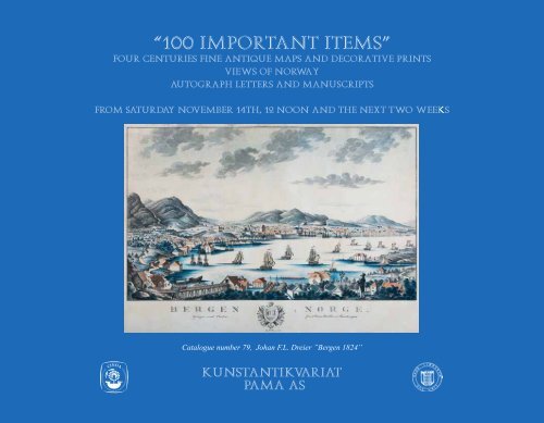
Catalogue number 79, Johan F.L. Dreier ”Bergen 1824”
Catalogue number 10, W. Barents “Map of the Arctic” 1598<br />
www.antiquemaps.no
«100 <strong>IMPORTANT</strong> ITEMS»<br />
KUNSTANTIKVARIAT PAMA - CATALOGUE 17 – 2009<br />
Four centuries fine antique maps and decorative prints<br />
Views of Norway<br />
Autograph letters and manuscripts<br />
From SATURDAY NOVEMBER 14th, 12 noon and the next two weeks<br />
Monday – Friday 10 – 18 (Thursday 19), Saturday 11 – 16, Sunday 12 – 16<br />
Oslo, November 2009<br />
Pål Sagen<br />
Bygdøy Allé 10, 0262 OSLO, Norway • Tlf: (+ 47) 22 44 06 00/(+47) 92 81 84 65 • Faks: (+47) 22 44 06 01.<br />
E-post: post@antiquemaps.no • Internet: www.antiquemaps.no<br />
Specialist in antique maps and prints, topographical views and illustrated books.<br />
<strong>Kunstantikvariat</strong> PAMA<br />
3
FOREWORD<br />
Dear all clients, colleagues, collectors and friends,<br />
November is here and so are new catalogues from <strong>Kunstantikvariat</strong> PAMA. The exhibtion a year ago confirmed the continuing strenght of the<br />
market and the increased interest for fine and high quality antique maps and decorative prints, rare illustrated books, early views of Norway and<br />
important autograph letters. Most numbers in the catalogue sixteen were sold within the two weeks of the exhibition.<br />
A few month ago <strong>Kunstantikvariat</strong> PAMA moved the business address to Bygdøy Allé 10 and the official opening of our new gallery will take<br />
place in connection with this exhibition.There are two main catalogues published for 2009. This ”general” catalogue, our firm’s seventeenth, and<br />
no. eighteen given the title ”The Golden Century of Beauty and Quality”. This last catalogue is specially devoted to Norwegian 19th century art.<br />
We are proud to present with you this interesting and beautiful assembling of important pictures. In addition, <strong>Kunstantikvariat</strong> PAMA has recently<br />
published a catalogue describing the map and book collection ”The Exploration of the North”. The unique collection consists of almost 150 items<br />
and is being offered as one single unit. The comprehensive and illustrated catalogue can be ordered on request.<br />
We wish you all very welcome to our exhibition in Bygdøy Allé 10!<br />
Pål Sagen<br />
Oslo, November 2009<br />
TERMS AND EXPLANATIONS<br />
All items has been carefully described and are guaranteed to be genuine and authentic.<br />
The prices are in NOK (Norwegian kroner). As an indication only, the items are also priced in EURO after an approximate<br />
exchange rate of € 1 = NOK 8,60<br />
Contemporary handcoloured: In our opinion, the colouring is approximately contemporary with the date of issue.<br />
Handcoloured: In our opinion, the colouring, or parts of the colouring originates from a later period than the date of issue.<br />
The expression “state” in English = in Norwegian: “De forskjellige stadier i bearbeidelsen av en kobberplate, treblokk eller litografisk sten”.<br />
4<br />
PLE<strong>AS</strong>E NOTE:<br />
THE CATALOGUE IS PUBLISHED SOME DAYS BEFORE THE OPENING OF THE EXHIBITION.<br />
IT IS THEREFORE POSSIBLE TO MAKE ORDERS FROM THE CATALOGUE BEFORE SATURDAY NOVEMBER 14 th , 2009<br />
www.antiquemaps.no
ATTENTION!<br />
FOR MANY MORE INTERESTING ANTIQUE MAPS, VIEWS, DECORATIVE PRINTS ETC.<br />
Please cheque our website:<br />
www.antiquemaps.no<br />
Braum - Hogenberg ”Moscavw” c. 1575<br />
VÆR OPPMERKSOM PÅ:<br />
På våre nettsider finnes ytterligere en stor, interessant samling med antikke kart, prospekter, dekorative bilder og trykk.<br />
Vennligst sjekk:<br />
www.antiquemaps.no<br />
<strong>Kunstantikvariat</strong> PAMA<br />
5
INDEX AND TOPOGRAPHICAL INDEX<br />
Africa:<br />
America:<br />
Arctic and Antarctic<br />
Artist’s illustrations:<br />
Asia with Russia:<br />
Atlases:<br />
Autograph letters & manucripts<br />
Bergen:<br />
Bodø:<br />
Buskerud:<br />
Decorative prints:<br />
Denmark:<br />
Europe:<br />
Finnmark:<br />
Flowers:<br />
Lofoten:<br />
Maritime views:<br />
Mediterranean:<br />
Norway, general:<br />
Oppland, Hedmark<br />
Oslo (Christiania), Akershus<br />
Scandinavia, general:<br />
Spitsbergen:<br />
Sweden:<br />
Telemark with Kragerø<br />
Tromsø:<br />
Trøndelag:<br />
Vestfold, Sandefjord<br />
Whaling:<br />
World:<br />
Østfold with Halden:<br />
6<br />
4<br />
3<br />
10, 11, 12, 14, 17<br />
44<br />
7<br />
25<br />
91 - 100<br />
45, 62, 71, 79, 83<br />
82<br />
59 - 61, 72 - 73, 80<br />
36 - 43<br />
6, 23<br />
5<br />
9, 21, 37, 81<br />
41<br />
89<br />
8 - 39, 43<br />
25<br />
10, 18, 20, 29, 32, 34<br />
35, 74 - 77<br />
16, 28, 30, 33, 47, 54 - 58, 64, 66 - 68, 85, 88,<br />
2, 10, 14, 22, 27<br />
19, 26,<br />
8, 13, 24, 32<br />
70, 78, 84, 86<br />
89<br />
63, 65<br />
16, 28, 87<br />
14, 36, 40<br />
1, 15<br />
16, 24, 28, 31, 46, 48, 49 - 53, 69<br />
www.antiquemaps.no
ANTIQUE MAPS FROM ALL OVER THE WORLD<br />
<strong>Kunstantikvariat</strong> PAMA<br />
7
1. SEB<strong>AS</strong>TIAN MÜNSTER (1489 - 1552)<br />
“Typus Orbis Universalis”<br />
Handcoloured woodcut, 26,5x38cm<br />
B<strong>AS</strong>EL c. 1550<br />
A fine example in old colour of the early woodcut world map. Signed in<br />
the block by the woodcutter David Kandal (DK). The map was in use<br />
until 1578 and our copy has German text on reverse. The map shows a<br />
good outline of the known world of the mid-16th century and is rich in<br />
the imaginary with its many sea monsters and windheads.<br />
A general age tone, good margins all around.<br />
(Ref: R. Shirley “Mapping of the world” no. 92)<br />
16 000,-<br />
(€1860)<br />
8<br />
www.antiquemaps.no<br />
2. OLAUS MAGNUS (1490 - 1557)<br />
[“Mappa Settentrionali”] “A map of the North”<br />
Engraved map, framed, 26,5x17,6cm<br />
Accompanied with a copy of the book “Historia Delle Genti Et Della<br />
Natura Delli Cosa Settentrionali” Venice 1565. Loose in a binding. (<br />
A photocopy of the map bound in and the leaves 20, 21, 28, 29, 283,<br />
284 are replaced in facsimilie)<br />
VENICE 1565<br />
THE SEPARATE MAP AND THE BOOK, THE FIRST ITALIAN<br />
FOLIO EDITION OF THE FAMOUS DESCRIPTION OF THE<br />
NORTHERN PEOPLE.<br />
The elegantly engraved map is unique for this edition and replaced the<br />
woodcut map from 1555.<br />
A browning in upper right corner.<br />
(Ref: W.B. Ginsberg “”Printed Maps of Scandinavia and The Arctic” no. 22, Mingroot-<br />
Van Ermen “Scandinavia in old maps and prints” no. 9)<br />
30 000,-<br />
(€3500)
3. ABRAHAM ORTELIUS (1527 - 98)<br />
“Americae sive Novi Orbis”<br />
Contemporary handcoloured engraving, 36x50cm<br />
ANTWERPEN 1579<br />
FIRST YEAR OF PUBLICATION. A FINE EXAMPLE OF ONE OF THE MOST FAMOUS MAPS OF THE NEW CONTINENT.<br />
A print from the second plate (of three) of the America map. This was in use from 1579 to 1587 and was only published in 5 editions of<br />
“Theatrum”. This second plate still has the bulge in the south-western coast of South America and is the most unusual of the three. Identical with<br />
the 1579 Latin edition according to Burden.<br />
Ortelius’s “Theatrum Orbis Terrarum” from 1570 is said to be the first atlas of the world were the maps were of a standard size. His maps had an<br />
enormous influence throughout Europe and were published in several languages and editions for more than 40 years. If you have a loose map from<br />
the “Theatrum-atlas”, there are reference works now available which can help you to distinguish the different editions.<br />
Three small printers creases lower left, some fraying to the edges of the margins. A very good copy!<br />
(Ref: Van den Broecke “Ortelius Atlas Maps” no. 10, P. Burden “The Mapping of North America” no. 52)<br />
<strong>Kunstantikvariat</strong> PAMA<br />
35 000,-<br />
(€4050)<br />
9
4. ABRAHAM ORTELIUS<br />
“Africae Tabula Nova”<br />
Contemporary handcoloured engraving, 38x51cm<br />
ANTWERPEN (1570) - 79<br />
A FINE, FRESH ORIGINAL COLOUR EXAMPLE OF THE<br />
FAMOUS CONTINENT MAP.<br />
From the same Latin atlas copy as the continent map of America, see the<br />
entry above.<br />
The upper edge slightly frayed.<br />
(Ref: Van den Broecke “Ortelius Atlas Maps” no. 8, Norwich “Mapping of Africa” no. 10)<br />
18 000,-<br />
(€2090)<br />
10<br />
www.antiquemaps.no<br />
5. ABRAHAM ORTELIUS<br />
“Europae”<br />
Contemporary handcoloured engraving, 34,5x46,5cm<br />
ANTWERPEN 1584 or later<br />
A decorative and much sought after map of the continent. Printed from<br />
the second plate first introduced in 1584 and replaced the one from<br />
1570, our example has Latin text and page number two. A fine colour<br />
copy printed on thick paper.<br />
(Ref: Van den Broecke “Ortelius Atlas Maps“ no. 5)<br />
13 000,-<br />
(€1510)
6. ABRAHAM ORTELIUS<br />
“Daniae Regni Typus” + “Cimbricae Chersonesi nunc Iutiæ”<br />
Contemporary handcoloured engraving, 34,5x49cm<br />
ANTWERPEN 1595 or 1601<br />
The last of three different Ortelius maps of Denmark and the most<br />
decorative one. Two separate maps on one sheet. The cartographical<br />
sources for the maps are supposed to be C. Anthoniszoon and M.<br />
Jordan. Latin text page 48 on the reverse, according to Van den Broecke<br />
from the 1595 or 1601 edition.<br />
The margin lower left and right with a browning, otherwise an excellent and decorative<br />
example.<br />
(Ref: Van den Broecke “Ortelius Atlas Maps” no. 86a + b, W.B. Ginsberg “Printed Maps<br />
of Scandinavia and the Arctic 1482 – 1601” Entry 24.7)<br />
10 000,-<br />
(€1160)<br />
<strong>Kunstantikvariat</strong> PAMA<br />
7. ABRAHAM ORTELIUS<br />
“Tartariae sive Magni Chami Regni Typus”<br />
Contemporary handcoloured engraving, 36x47cm<br />
ANTWERPEN (1570) - 1587<br />
AN <strong>IMPORTANT</strong> AND INFLUENTIAL MAP OF PARTS OF RUSSIA<br />
AND THE FIRST MAP TO FOCUS ON THE AMERICAN WEST<br />
AND NORTHWEST.<br />
A striking example with beautiful period colour. Ortelius attempt of<br />
making this map was to show the existence of the Strait of Anian<br />
between Russia and Alaska even this was long time before the actual<br />
existence of it was known. On the back French text and page “92“.<br />
Mounted along the edges, otherwise excellent.<br />
(Ref: Van den Broecke “Ortelius Atlas Maps” no. 163)<br />
18 000,-<br />
(€2090)<br />
11
8. HIERONYMUS SCHOLEUS<br />
“Stockholm”<br />
Contemporary handcoloured engraving, 33x49cm<br />
KÖLN c. 1588<br />
AN EXCELLENT ORIGINAL COLOUR EXAMPLE OF THE EARLY <strong>IMPORTANT</strong> STOCKHOLM VIEW.<br />
From Braun & Hogenberg“Civitates Orbis Terrarum” volum IV, Latin text page 38. Based on a drawing by Scholeus who also did the view of<br />
Bergen. The upper view was drawn from north-west dominated by “Det Kongelige Slott”, the lower one seen from south-east. At the end of the16th<br />
century the population of Stockholm was c. 10 000.<br />
(Ref: Mingroot - Van Ermen “Scandinavia in old maps and prints” no.15)<br />
16 000,-<br />
(€1860)<br />
12<br />
www.antiquemaps.no
9. LUC<strong>AS</strong> J. WAGHENAER (1533 - 1606)<br />
“Description des Costes de la plus Septentrionale partie de Norwege...Hydrographica Septentrionalis Norvegiæ...Beschrijuinghe der Zeecusten<br />
vant Nordelixte deel van Norweghen”<br />
Engraved map, 33,5x51,5cm<br />
AMSTERDAM (1596) - c. 1605<br />
THE RARE AND THE HIGHLY <strong>IMPORTANT</strong> CHART OF FINNMARK AND THE RUSSIAN LAPPLAND.<br />
Published in the late Waghenaer atlases only. Covers the coastline from “Malstroom” and “Veroy” to “Kola“. Two insets of “Wardhus” and<br />
“Kildyn”. Drawn by Pieter van den Keere and signed and dated 1596 in the plate. Verso French text signature “XXVII 2” and illustrations of coastal<br />
profiles of “Kildin”, “Stappen” and “Nortcap”.<br />
Restorations along lower centrefold with a few letters filled in, one repaired hole in lower margin and a new backstrip.<br />
(Ref: Map Collector’s Circle 719, R.V. Tooley “Maps and Map-Makers” London 1970 illustrated p. 131, “Old“ Koeman Wag 11C)<br />
90 000,-<br />
(€10450)<br />
<strong>Kunstantikvariat</strong> PAMA<br />
13
10. WILLEM BARENTS (1550 - 97)<br />
“Deliniatio cartæ trium navigationum per Batavos, ad Septentrionalem<br />
plagem...Beschrÿvinghe van drie Seÿlagien door de Hollanders gedaen<br />
ande Noordt syde van Noor:weghen, Moscovia, nova Sembla, ende door<br />
de Weygats...”<br />
Engraved map by Baptist Van Doetecum, 41,8x56,7cm<br />
AMSTERDAM 1598<br />
A MAJOR LANDMARK IN ARCTIC CARTOGRAPHY, THE FIRST<br />
MAP TO DEPICT SPITSBERGEN.<br />
This very rare and much sought after map is based on information by the<br />
Dutch map maker and explorer Willem Barents and his three voyages to<br />
the north 1594, 95 and 96/97. The track of the last journey is shown on<br />
the map. Barents’ theory was to attempt to find a northeastern passage<br />
of open waters to the Pacific in the North Polar region. During the last<br />
voyage Barents and his crew became stuck on the ice and were forced<br />
to winter on the ice in the Polar regions of Novaya Zembla. Before this<br />
he rediscovered Spitsbergen and reached the Bear Island on July 1,<br />
14<br />
www.antiquemaps.no<br />
1596. In June 1597 Barents died here (in 1870’s Norwegian seal hunters<br />
discovered Barents winter place at Novaya Zembla) and the remainder<br />
of the crew (12 of 17) reached Kola and finely returned to Amsterdam<br />
in November 1597. Among the papers they brought with them was a<br />
sketch and a manuscript of a North Polar map drawn by Barents. It was<br />
copper engraved by Van Doetecum and published separately in 1598 by<br />
Cornelis Claesz or included in a few copies of Linschoten’s “Navigatio<br />
ac Itinerarium...”. Linschoten accompanied Barents on parts of his two<br />
first voyages.<br />
This highly decorative map contains 34 illustrations of sea monsters,<br />
ships and whales and the island “Polus Magnetis”.<br />
The usual folds, some browning along the upper horizontal fold. In<br />
general in a very fine condition with proper margins. A good impression.<br />
(Ref: W.B. Ginsberg “Printed Maps of Scandinavia and the Arctic 1482 - 1601” entry<br />
46, MCC no.18, Dr. F.C. Wieder “The Dutch Discovery and mapping of Spitsbergen<br />
1596 - 1829“ no. 1, “Kompassrosen Orientering mot nord” Nasjonalbiblioteket 2009<br />
pages 55-56 illustrated, Mingroot/Ermen “Norge og norden på gamle kart og trykk” no. 21)<br />
P.O.R.
<strong>Kunstantikvariat</strong> PAMA<br />
15
11. GERHARD MERCATOR (1512 - 94)<br />
“Septentrionalium Terrarum descriptio”<br />
Contemporary handcoloured engraving, 37x39cm<br />
AMSTERDAM (1595) - c. 1609 - 19<br />
FAMOUS CIRCULAR POLAR MAP, ALSO DEPICTING<br />
SCANDINAVIA AND PARTS OF AMERICA AND <strong>AS</strong>IA.<br />
Clearly shown is the North Pole as the centre of the four streams. This<br />
idea was not based on any exploration and one explanation is that it<br />
goes back to mediaeval hand drawn T-O maps with Jerusalem in the<br />
centre and that the world’s four great rivers each had their source in<br />
Paradise. On the North Pole itself the map shows a mythical mountain.<br />
This is the second state of the map after re-engraving to include<br />
Spitsbergen and to changes of the shape of Nova Zemla. Shown is also<br />
the Northwest Passage that influenced English explorers. Our example<br />
is a French text edition page 41 published by the Mercator-Hondius map<br />
publishing business founded in 1604.<br />
A FINE EXAMPLE IN ORIGINAL COLOUR.<br />
(Ref: W. B. Ginsberg “Printed Maps of Scandinavia and the Arctic 1482 - 1601”<br />
Entry 33, fig. 33,3, “Old” Koeman Me23A, “Kompassrosen Orientering mot nord”<br />
Nasjonalbiblioteket, Oslo 2009 , Kershaw “Printed Maps of Canada” 23C, P. Burden<br />
“The Mapping of North America” 88, F. C. Wieder “The Dutch Discovery and mapping<br />
of Spitsbergen 1596 - 1829“ no. 12)<br />
28 000,-<br />
(€3250)<br />
16<br />
www.antiquemaps.no<br />
12. GERHARD MERCATOR - J. HONDIUS<br />
“Polus Arcticus cum vicinis regionibus”<br />
Contemporary handcoloured engraving, 13,5x18,5cm<br />
AMSTERDAM 1607<br />
FIRST EDITION IN ORIGINAL COLOUR.<br />
The reduced North Pole map of the second state of Gerhard Mercator’s<br />
“Septentrionalium Terrarum”, see the entry above. Though there are a<br />
couple of noticeable differences. The map itself extends only down to<br />
the Arctic Circle and the small inset maps at the top of the Faeroes and<br />
Frisland have been reversed. Published in Mercator-Hondius “Atlas<br />
Minor”, first edition with Latin text and no page number verso.<br />
Excellent.<br />
(Ref: P. Burden “The Mapping of North America” 154, Kershaw “Printed Maps of<br />
Canada” entry 25a)<br />
9 000,-<br />
(€1045)
FROM THE COLLECTION OF PRINCE FREDERICK,<br />
DUKE OF YORK AND ALBANY<br />
13. SWEDISH MAP DRAWER c. 1640-1672<br />
“Tabula Geographica öffwer Koparbergslaget och underliggiande<br />
Sochnar. nembligen Swalsiö, Sunneborn wijka och Torsånger, med alla<br />
Siögar, Strømar, Hÿttor och Gårdar Affrijtat. Anno 1640. Item 1672”<br />
Manuscript map on paper in ink and watercolour, 99,5x67cm<br />
PROBABLY SWEDEN 1640 - 1672<br />
A VERY EARLY AND HIGHLY INTERESTING MANUSCRIPT MAP<br />
OF AN <strong>IMPORTANT</strong> ECONOMIC AND MINING DISTRICT OF<br />
FALUN IN SWEDEN.<br />
To the left is the following note: “Mit 12 Separate Risse, über die<br />
Königl. Schwedische die zu gehörige Kupfer=berge.”<br />
Our map seems to be a replica to the map from 1640 with the same title<br />
now in Riksarkivet, Sweden with the archive number “U.5”, but our<br />
copy seems to have been partly updated and completed in 1672. These<br />
changes are done in a different pen than rest of the map.<br />
Provenance: From the collection of Duke of York, collector’s label on<br />
the reverse. Sold in auction at Sotheby’s May or July 1827. The lion and<br />
the crown are symbols of the Kingdome of England. We are grateful to<br />
Göran Bäärnhielm for providing useful information about this map.<br />
45 000,-<br />
(€5230)<br />
<strong>Kunstantikvariat</strong> PAMA<br />
17
14. HENDRICK HONDIUS (1597 - 1651)<br />
“Poli Arctici Et Circumtacentium Terrarum Descriptio Novissima” + “Polus Antarcticus”<br />
2 contemporary handcolored engravings, each c. 43,5x49cm<br />
AMSTERDAM c. 1664<br />
A FINE , CL<strong>AS</strong>SIC PAIR OF MAPS OF THE POLES.<br />
A uniform pair, the North Pole map, according to Burden, is in its unusual state 4 with the J. Janssonius imprint. This map (first state is 1636) is<br />
a modernized version of the Mercator Polar map from 1595/1606, see entry 10. On the Antarctic map, both cartouches are left blank in this state.<br />
Both maps have no text verso. “Poli Arctici” is surrounded by vignettes of arctic whaling. The “Polus Antarcticus” map has scenes with natives<br />
from the south Pacific, Pategonia. Magellanica and Cape of Good Hope. Tooley writes in “Mapping of Australia” no.10: “the first printed map as<br />
far as I know to show the discovery of Peter Nuyts land, or part of the south coast of Australia and was the best map of Australia prior to Tasman’s<br />
discoveries”.<br />
Both maps backed with fine tisssue paper, some restorations (mainly the Arctic map) along the centrefold.<br />
(Ref: The Arctic map: P. Burden “The Mapping of North America” 246 “state 4”, Kershaw “Printed Maps of Canada” entry 101 “third state”, W. B. Ginsberg “Septentrionalium -<br />
An Exhibit 2001” no. 44)<br />
32 000,-<br />
(€3720)<br />
18<br />
www.antiquemaps.no
15. WILLIAM J. BLAEU (1571 - 1638)<br />
“Nova Totius Terrarum Geographica Ac Hydrographica Tabula”<br />
Handcoloured engraving, 41x55cm<br />
AMSTERDAM 1641<br />
A FAMOUS “MERCATOR-PROJECTION MAP” OF THE GOLDEN AGE OF DUTCH MAP MAKING.<br />
The first world map by Blaeu and was in use until it was replaced by the double hemisphere map in “Atlas Major” c. 1662. Engraved by Josua van<br />
den Ende. First published c. 1606 as a separate sheet, in an atlas from c. 1630. This copy comes from an early German text edition “Atlas Novus”<br />
from 1641. The map is a fine example of cartography as art. The border panels on all four sides show the five known planets with the sun and the<br />
moon, symbols of the four elements and the four seasons. Lower border has the seven wonders from the ancient world. Decorative elements include<br />
several ships, sea monsters and compass cards. Also depicted is the interest in and exploration of the North-East passsage.<br />
The full sheet laid down on a fine transparent Japan - tissue paper. Three weak folds along the centrefold and in the right part of the map, a closed tear in lower margin. A decorative<br />
copy.<br />
(Ref: R. Shirley “Mapping of the world” no. 255, state 4, “Old” Koeman 31A, F. C. Wieder “The Dutch Discovery and mapping of Spitsbergen 1596 - 1829“ no. 56,<br />
W. B. Ginsberg “Norvegia” no. 48)<br />
70 000,-<br />
(€8100)<br />
<strong>Kunstantikvariat</strong> PAMA<br />
19
16. Sir, ROBERT DUDLEY (1574 - 1649)<br />
“Carta particolare che comincia con la Iutlandia è contiene parte della<br />
costa di Suetzia è della Noruegia La longitudine comincia da l’Isola di<br />
Picho di Asores. di Europa Carta XXXVIII”<br />
Engraving, 48x75cm<br />
FLORENCE 1646<br />
First edition map. It depicts the Norwegian coastline from Arendal to<br />
Oslo, further with Østfold and down along the Swedish west coast. A<br />
map from the sea atlas “Dell’ Arcano del Mare” (Secrets of the Sea)<br />
published in 1646 and 1661 only. The charts from Dudley’s sea atlas is<br />
noteworthy that for the first time sea charts were drawn in the Mercator<br />
projection. The engraver was Antonio Lucini and it is claimed that he<br />
used 12 years and over 2000 kilograms of copper to engrave the plates.<br />
Excellent condition.<br />
(Ref: W. B. Ginsberg “Norvegia Regnum” no. 82)<br />
20<br />
16 000,-<br />
(€1860)<br />
www.antiquemaps.no<br />
17. WILLIAM and JOAN BLAEU<br />
“Regiones Sub Polo Arctico”<br />
Contemporary handcoloured engraving, 41x53cm<br />
AMSTERDAM c. 1649<br />
A beautiful map of the Arctic area. With a dedication coat of arms<br />
belonging to Guillelmo Backer. Latin text and “4C” verso.<br />
A fine copy with fresh colours.<br />
(Ref: P. Burden “The Mapping of North America” no. 252 state 2 (of 2), Kershaw “The<br />
Mapping of Canada” entry 127a)<br />
9 000,-<br />
(€1045)
18. (W.J. BLAEU) - JOAN BLAEU<br />
“Dioecesis Stavangriensis”<br />
Contemporary handcoloured engraving, 41x50cm<br />
AMSTERDAM 1640<br />
THE FIRST BLAEU MAP RELATING TO NORWAY.<br />
It shows the Bishopric of Stavanger and the adjacent regions very<br />
similar to that of Janssonius published four years earlier. It says in the<br />
cartouche that it is based on the work by Laurids Clausen Scavenius<br />
(1562 - 1626) who was bishop of Stavanger. German text on the back,<br />
identical with “Old” Koeman Bl.33, from “Novus Atlas”.<br />
Excellent!<br />
(Ref: W.B. Ginsberg “Maps and Mapping of Norway 1602–1855. BLA 1)<br />
9 000,-<br />
(€1045)<br />
<strong>Kunstantikvariat</strong> PAMA<br />
19. JAN JANSSONIUS (1588 - 1664)<br />
“Spitsberga”<br />
Contemporary handcoloured engraving,<br />
41x51cm<br />
AMSTERDAM 1659<br />
First edition of the scarce and one of the<br />
earliest special map of Spitsbergen.<br />
Provenance: From the collection of Prince<br />
Frederick, Duke of York and Albany,<br />
collector’s label on the reverse.<br />
(Ref: W. B. Ginsberg “Maps and Mapping of Norway<br />
1602 - 1855” JJ5, illustrated JAN 5, “Old” Koeman<br />
Me 166, F. C. Wieder “The Dutch Discovery and<br />
mapping of Spitsbergen 1596 - 1829” no. 186, lists the later Valk and Schenk issue)<br />
8 000,-<br />
(€930)<br />
21
20. JOAN BLAEU (1596 - 1673)<br />
“Norvegia Regnum vulgo Nor-Ryke”<br />
Contemporary handcoloured engraving, 41,5x50cm<br />
AMSTERDAM (1659), but c. 1662<br />
PERHAPS THE MOST DECORATIVE SPECIAL MAP OF NORWAY.<br />
The second printed map of the country. Richly decorated with<br />
cartouches and coats of arms, the cartouche lower right with a<br />
dedication to Prince Christian who became the King Christian V in<br />
1670. The map depicts Norway up to Senja.<br />
(Ref: W. B. Ginsberg “Maps and Mapping of Norway 1602 - 1855” no. 2, W. B.<br />
Ginsberg “Norvegia” no.51 illustrated on the cover, Mingroot-Ermen “Scandinavia in<br />
old maps and prints” no.39, Hoem “Norge på gamle kart” p. 49)<br />
28 000,-<br />
(€3250)<br />
22<br />
www.antiquemaps.no<br />
21. JOAN BLAEU<br />
“Finmarchia”<br />
Contemporary handcoloured engraving, 39x55cm<br />
AMSTERDAM 1662<br />
The first local map of the interior of Finnmark though there are only<br />
names along the coastline. It is interesting that some of them have Sami<br />
origin. Published in Blaeu’s “Atlas Major”.<br />
(Ref: W. B. Ginsberg “Maps and Mapping of Norway 1602 - 1855” (No. 2) BLA 6,<br />
Hoem “Norge på gamle kart” no. 47)<br />
6 500,-<br />
(€750)
22. ELISABETH VISSCHER<br />
“La Scandie ou Les Trois Royaumes du Nord Suede, Danemarc &<br />
Norvegue Dedieé au tres puissant Et tres Invincible Prince, Carl XII”<br />
Contemporary handcoloured engraving, 59x72,5cm<br />
AMSTERDAM c. 1706<br />
A FINE COPY OF THE LARGE AND SCARCE MAP WITH A<br />
DEDICATION TO CARL XII.<br />
Elisabeth was N. Visscher II’s widow and she had her own privilege<br />
to print books and maps. She used some of her husband’s plates, but<br />
others, like this of Scandinavia was new. The size is larger than usual.<br />
Our copy was published by Pieter Schenk.<br />
Folds as issued, one restored tear extends a few centimetres into the map, some marginal<br />
tears.<br />
27 000,-<br />
(€3140)<br />
<strong>Kunstantikvariat</strong> PAMA<br />
23. JOHN SENEX (fl. c. 1700 - 46)<br />
“Denmark Corrected From the Newest Observations...”<br />
Contemporary handcoloured engraving, 67x97cm<br />
LONDON c. 1710<br />
An impressive, large map of Denmark with a exquisite handcolour of<br />
the period.<br />
7 500,-<br />
(€870)<br />
23
24. GUSTAF TÖRNEBOHM<br />
“Geografisk Carta af Bohus Lähn och Dahl med sijdan af Wermeland utwijsandes norska gräntzen med en deel af Aggerhus Lähn som stöter in<br />
Till. Uddevalla A: 1715 G. Törnebohm”<br />
Detailed manuscript map in watercolours and ink, 35,5x55,5cm, mounted on grey thick paper 54x65cm<br />
Signed and dated 1715 in the decorative cartouche in form of a shell upper left.<br />
Drawn in UDDEVALLA, Sweden 1715<br />
A UNIQUE AND <strong>IMPORTANT</strong> DOCUMENT RELATED TO THE BORDER OF SWEDEN AND NORWAY. THE MAP IS EXECUTED THE<br />
SAME YEAR 1715 WHEN CARL XII WENT INTO NORWAY IN FEBRUARY.<br />
Shows a large part of the Swedish province of Bohuslän from Gothenburg and Hisingen and extends to the Norwegian border with Frederikshald<br />
and Aggershuus Lähn with Fredriksstad, Hvaler, Ørje in the east and Øyeren in the north. Gustaf Törnebohm was an officer trained in military<br />
architecture as well as cartography, and began his career in the fortification at the end of 17th century. After some years in Narva and Reval, he was<br />
appointed captain in 1710 and was transferred to Bohuslän near the Norwegian border. He died in 1717 as a commander at Sundsborg in Bohuslän.<br />
The finely and detailed manuscript map is drew during a very important period in the Nordic history in the years with Carl XII’s several attempts to<br />
conquer Norway.<br />
In a fresh, original condition. Some folds.<br />
Provenance: The collection of Ericksberg Castle, Sweden<br />
85 000,-<br />
(€9880)<br />
24<br />
www.antiquemaps.no
<strong>Kunstantikvariat</strong> PAMA<br />
25
25. HENRY MICHELOT & LAURENT BREMOND<br />
“Recüeil de Plusieurs Plans des Ports et Rades de la Mer Mediterranée”<br />
Atlas, oblong 4to, 20,6x28cm, with engraved title and 37 full page engraved maps/charts, contemporary mottled calf.<br />
(Rubbed, both joints partly cracked, old handwriting on inside front cover)<br />
PARIS 1727 - 30<br />
AN INTERESTING SPECIAL SEA ATL<strong>AS</strong> WITH 37 DETAILED CHARTS OF MEDITERRANEAN PORTS IN SPAIN, FRANCE AND<br />
ITALY. THE BOOK H<strong>AS</strong> OLD NORWEGIAN PROVENANCE.<br />
The complete book is in a very good condition with the maps in strong, black impressions. The maps are engraved by P. Starckman. Among the<br />
charts are harbour plans of Cadis, Gibraltar, Barcelona, Antibe, Marseilles, Nice, Palermo, Genova, Messina and Neapel. The book has an owner<br />
history through Norwegian sea captains. Owner’s name “HC Wathne 20. october 1776” on the inside front cover.<br />
25 000,-<br />
(€2770)<br />
26<br />
www.antiquemaps.no
FROM THE COLLECTION OF PRINCE FREDERICK,<br />
DUKE OF YORK AND ALBANY<br />
26. GERARD VAN KEULEN<br />
“Niuwe aftekeningen van Het Eyland Spits-Bergen”<br />
Engraved map, 52x59cm<br />
AMSTERDAM c. 1728<br />
A RARE CHART OF SPITSBERGEN AND A PROTOTYPE FOR LATER MAPS.<br />
Cartographically based on Giles who sailed around the islands in 1707. According to Koeman it seems to have been published in 1728, but Wieder<br />
says 1714. Gerard was the son and successor of Johannes van Keulen who founded the succesfull sea map business in Amsterdam in 1680. The Van<br />
Keulen map publishing business continued to early 1800.<br />
Provenance: From the collection of Duke of York, collector’s label on the reverse. Sold in auction at Sotheby’s May or July 1827.<br />
(Ref: F. C. Wieder “The Dutch Discovery and mapping of Spitsbergen 1596 - 1829” no. 213 Giles)<br />
<strong>Kunstantikvariat</strong> PAMA<br />
24 000,-<br />
(€2800)<br />
27
27. HERMAN MOLL (died 1732)<br />
“A New map of Denmark and Sweden According to the Newest and most Exact Observations”<br />
Contemporary handcoloured engraving, 60x102cm<br />
LONDON (c. 1710) – c. 1733 or later<br />
An impressive, large map of Scandinavia and the north. The map is a very good example how the European had a focus on the extreme North<br />
during the 18th century. Famous are the illustration panels on the right hand side, some of them based on J. Scheffer and his work from 1671. The<br />
text says: “The Laplanders being the most Remarkable People in Europe...“. According to N. G. Germundson’s list this is probably state 5 of the<br />
map, most of the differences are changes in the address panel lower left. A fully old coloured example in an unusually good condition.<br />
(Ref: W. B. Ginsberg “Septentrionalium-An Exhibit 2001” no.42, Mingroot-Ermen “Scandinavia in old maps and prints“ no.61, N.G. Germundson, Zürich, a list of the different<br />
states of the Moll map of Scandinavia, Ulla Ehrensvärd “The History of the Nordic Map from Myths to Reality“ Nurminen Foundation Helsinki 2006 no. 171)<br />
28 000,-<br />
(€3250)<br />
28<br />
www.antiquemaps.no
28. MOUNT & PAGE, AFTER SEA CAPTAIN JOHAN HEITMAN<br />
“A New and Exact Map of Part of the Coast of Norway begining at Long Sound w:th the East &NE Coast thereof: also the Soen Water, Dram and<br />
Christiania Rivers. With all the Sunk Rocks Straits Bays & Anchoring places on y:t Coast up to Fredrick Stade & c Printed by B. Crowe”<br />
Engraved map, 58x97cm<br />
LONDON c. 1740<br />
THE MUCH SOUGHT AFTER SPECIAL LARGE CHART OF THE OSLO FJORD.<br />
The important chart was published by the English sea chart business Mount & Page who was the successor of the famous sea chart publisher John<br />
Seller. The map is based on a Van Keulen issue some years earlier, but the original source of the map is a drawing by the Norwegian Sea Captain<br />
Johan Heitman (1664 - 1740). With two insets, upper left a detail of “Noter Øen” and the surrounding area with Wasser, Tjøme etc.<br />
Folds as issued, occassional browning, but in a very good condition.<br />
(Ref: “Norges Sjøkartverk 1932 - 82” Stavanger 1983 illustrated p. 62, Map Collector’s Circle “Printed Charts of Scandinavia” no. 529)<br />
45 000,-<br />
(€5200)<br />
<strong>Kunstantikvariat</strong> PAMA<br />
29
29. OVE A. WANGENSTEEN (died 1763)<br />
“Kongeriget Norge afdelet i sine fiire Stifter, nemlig Aggershuus,<br />
Christiansand, Bergenhuus og Tronhjem samt underliggende<br />
Provstier”<br />
Engraved map, outlinecoloured, 56,5x48cm<br />
HAMBURG 1761<br />
THE FIRST MAP OF NORWAY DRAWN AND<br />
ISSUED BY A NORWEGIAN CARTOGRAPHER.<br />
Still designed after de Wit’s model with Northern part of Norway upper<br />
left, but improved cartographically and now also with Norwegian place names.<br />
A fine, fresh copy with wide margins!<br />
(Ref: W. B. Ginsberg “Maps and Mapping of Norway 1602 - 1855” no. 21, Ginsberg<br />
“Norvegia” no.63, Hoem no.27)<br />
15 000,-<br />
(€1740)<br />
30<br />
www.antiquemaps.no<br />
30. OVE A. WANGENSTEEN<br />
“Aggershuus Stift, afdelet I sine Amter og Fogderier Med Kongelig<br />
Allernaadigst Tillatelse og Bevilling 1762...”<br />
Engraved map, outlinecoloured, 57x48cm<br />
HAMBURG 1763<br />
THE FIRST LOCAL MAP OF OSLO AND THE SURROUNDINGS.<br />
The rare map shows “Akershus Stift” which then included the different<br />
“Amts” Smaalenene, Akershus, Oplandene, Buskerud og Bratsberg and<br />
the “Grevskapene” Jarlsberg and Laurvig (now Vestfold). The fortresses<br />
Aggershuus and Friderichsteen are shown in the cartouches.<br />
Excellent.<br />
(Ref: W. B. Ginsberg “Maps and Mapping of Norway 1602 - 1855” (no. 21) - WAN 1,<br />
Ginsberg “Scandia” no.CE59, Hoem no.53 illustrated)<br />
20 000,-<br />
(€2325)
31. CHRISTIAN J. PONTOPPIDAN<br />
“Det Sydlige Norge” (in 2 sheets) and ”Det Nordlige Norge”<br />
3 handcoloured engravings, each c. 55x71cm<br />
Sold with the book with the explanation text to the maps, 8vo. “Geographisk Oplysning til Cartet over det sydlige Norge”, first issue København<br />
1785 and “Geographisk Oplysning til Cartet over det nordlige Norge”, 2nd issue København 1806. Cont. half calf, slightly rubbed<br />
KØBENHAVN 1785 and 95<br />
An important, detailed map in Norway’s history of cartography. Accompanied with the descriptive text book. The most correct map of Norway<br />
up to the time and the number of names on the map is overwhelming. Here present, as originally published, in three separate parts and sheets, not<br />
joined. The maps are in their third and second printing state according to Ginsberg. With large untrimmed margins. Some light creasing only. The<br />
book is in good condition.<br />
(Ref: Ginsberg “Maps and mapping of Norway 1602 - 1855” no.31-state 3 and no.38-state 2, Ginsberg “Norvegia” no.70-71, “Scandia” 64-65)<br />
13 000,-<br />
(€1510)<br />
<strong>Kunstantikvariat</strong> PAMA<br />
31
32. SWEDISH MAP DRAWER 1789<br />
“Geometrisk Charta Öfver IDE FJORDEN På Isen afmålt och pliktad uti Januarii och februarii Månadene År 1789.”<br />
Ink and watercolour, 226x108x50cm in a “L-shape”<br />
SWEDEN probably the winter 1789<br />
UNIQUE MANUSCRIPT MAP OF THE NORWAY - SWEDEN BORDER AREA OF IDDEFJORDEN, SVINESUND AND THE ROUTE TO<br />
HALDEN.<br />
The large size and the special shape makes it to a very special piece. Perhaps executed in a connection with an official border commission. The<br />
Svinesund-Halden border area was the most important between Norway/Denmark and Sweden and several war actions took place here through the<br />
17th/18th century. This is of particular interest since it is a “winter map” and this is why the map is drawn in a “grisaille” style of colours.<br />
Some tears, mostly marginal. A small pice without geographical information torn off, otherwise in very good original condition.<br />
40 000,-<br />
(€4650)<br />
32<br />
www.antiquemaps.no
226cm<br />
<strong>Kunstantikvariat</strong> PAMA<br />
108cm<br />
33
33. NIELS A. RAMM and GERHARD MUNTHE<br />
“Kart over Agershuus Amt”<br />
Contemporary handcoloured engraving, 62x45,5cm divided in 18<br />
segments.<br />
Early cloth, the map folded 17,5x12cm, title in gilt on front cover<br />
“Agerhuus Amt”<br />
PARIS 1827<br />
First edition from the first set of “Amt-maps” of Norway. A finely<br />
engraved map with a detailed inset of Christiania upper left. Unusual in<br />
a presentation like this.<br />
(Ref: W.B. Ginsberg “Maps and Mapping of Norway 1602 - 1855” RM 2 illustrated<br />
page 238, Ginsberg “Norvegia Regnum” no. 74 illustrated page 25)<br />
6 000,-<br />
(€700)<br />
34<br />
www.antiquemaps.no<br />
34. J. A. WALIGORSKI & H. N. WERGELAND<br />
“Veikart over Norge Udarbeidet efter de bedste Kilder af J. Waligorski<br />
og N. Wergeland.” og<br />
“Kart over det nordlige Norge eller Tromsö Stift indbefattende Amter<br />
Fogderier”<br />
Outlinecoloured lithograph, 110x77cm, mounted on canvas divided in<br />
30 segments.<br />
EISENACH, Germany 1847<br />
FIRST EDITION OF THE FIRST LARGE ROAD MAP OF NORWAY.<br />
Printed on two sheets, joined. Josef Waligorski (1794 - 1873) was a<br />
Polish officer and ingenieur who came to Norway around 1835 and got<br />
some years later the position as canal director. Harald N. Wergeland<br />
(1814 - 93) was a Norwegian officer born in Bergen. From 1840 he had<br />
a position at “Norges geografiske Opmaaling“. Lower right an inset<br />
“Kart over de fornemste Router i Europa”. The “Veikart” was published<br />
over a period of almost 50 years.<br />
Some occasional browning.<br />
(Ref: W.B. Ginsberg “Maps an Mapping of Norway 1602-1855” entry 75 illustrated<br />
page 169. J.W. Cappelens Antikvariat “Norge i kart Gjennom 400 År” Oslo 1952, pages<br />
106-107 and entries 273 - 274, later editions only)<br />
7 000,-<br />
(€810)
<strong>Kunstantikvariat</strong> PAMA<br />
35. CARL SCHWENZEN<br />
(Lithographer, active Christiania c. 1850 - 82)<br />
“Lommekart over Mjösen og Omegn især til Brug paa Kysttoure<br />
og Reiser et Uddrag af Amtskartene ved Carl Schwenzen Premier<br />
Lieutenant 1854”<br />
Coloured lithograph, 44x31cm, on canvas and divided in 9 segments<br />
CHRISTIANIA 1854<br />
An early and detailed local map of Mjøsa and the surrounding area of<br />
Oppland and Hedmark.<br />
7 500,-<br />
(€870)<br />
35
36<br />
A detail of catalogue number 9.<br />
www.antiquemaps.no
DECORATIVE PRINTS AND ONE ILLUSTRATED<br />
BOOK WITH AN ETCHING BY MUNCH<br />
<strong>Kunstantikvariat</strong> PAMA<br />
37
36. HEINRICH HEUSS<br />
“Abriss Eines Kopffs von einem Einhorn/ Der dem gemeinen Lauff der<br />
Natur zugegen/ mit zwey Hörner versehen/ und Anno 1684 in Grönland<br />
gefangen worden.”<br />
Typographical print and engraving, the sheet including the text<br />
40x32cm, the engraving 11,5x31cm<br />
HAMBURG 1684<br />
EXTREMELY RARE FLY-LEAF OF WHALING IN THE ARCTIC<br />
SEA.<br />
The picture shows a narwhal caught in Greenland in 1684 and its skull<br />
with double tusks is seen from both sides! Key “D” shows the holes<br />
where the whale spurts out the water. In the middle an unborn narwhal<br />
in original size. The narwhal is a medium-sized toothed whale found<br />
primarily in Canadian Arctic and Greenland waters. Narwhals have been<br />
harvested for thousands of years by Inuit people for meat and ivory and<br />
a regulated subsistence hunt continues to this day. Narwhal tusks were<br />
once commonly belived to be horns from the legendary unicorns.<br />
Folds as issued, in excellent condition.<br />
15 000,-<br />
(€1740)<br />
38<br />
www.antiquemaps.no
37. HENRY A. CHATELAIN (1684 - 1743)<br />
“Representations des Lapons”<br />
6 handcoloured engravings, each c. 34x20,5cm<br />
AMSTERDAM c. 1714<br />
A most decorative and famous set in an excellent condition. There are 23 illustrations and a map. They intend to illustrate the manners and the<br />
customs of the Lapplanders, how they were looked upon from a European view in the 17th and 18th century. Most of the information are based on<br />
travellers to the North like Olaus Magnus, Johannes Scheffer and Francesco Negri.<br />
From Chatelain’s work “Atlas Historique”.<br />
18 000,-<br />
(€2090)<br />
<strong>Kunstantikvariat</strong> PAMA<br />
39
38. HENRY A. CHATELAIN (1684 - 1743)<br />
“Nouvelle Carte pour conduire à la Connoissance de la Marine et à demontrer la plus part des Instrumens”<br />
Handcoloured engraving, 50x58,5cm<br />
AMSTERDAM c. 1714<br />
A most decorative and detailed marine print also heightened with gold. There is a fregatte ship in the centre, this is drawn with a wealth of detailes.<br />
Excellent condition!<br />
20 000,-<br />
(€2500)<br />
40<br />
www.antiquemaps.no
39. JOHANN B. HOMANN (1663 - 1724)<br />
“Flaggen Aller Seefahrenden Potenzen und Nationen der Gantzen<br />
Weldt”<br />
Contemporary handcoloured engraving, 49x58cm<br />
NÜRNBERG c. 1730<br />
A very decorative sheet with 139 sea flags of all nations. The maritime<br />
flag of Bergen represents Norway. Lower right is a key colour guide<br />
panel. At the time there were different publications of the print, our<br />
example is the “deluxe” with all the flags finely coloured individually.<br />
15 000,-<br />
(€1740)<br />
<strong>Kunstantikvariat</strong> PAMA<br />
40. ITALIAN ENGRAVER c. 1770 - 80<br />
“Navigatio Piscatorum in glacie quaerentium Balaenam - La<br />
Navigation dans la glace, et chercher du Baleine.”<br />
Contemporary handcoloured engraving, 26x40cm<br />
ITALY 1770 - 80<br />
A decorative whaling scene from the Arctic Sea. This is a rare Italian<br />
pirate copy after G. Probst who published a set of whaling prints in<br />
Augsburg shortly before.<br />
Some discolouration along the side margins.<br />
7 000,-<br />
(€810)<br />
41
41. MATTHÄUS SEUTTER (1658 - 1747)<br />
“Ein Orlog - oder Grosses Kriegs-Schiff nach seiner Vornehmsten theilen...Ein Orlog - oder Kriegs-Schiff mit seinen Masten, Thouen, Seeglen und<br />
Flaggen ausgerüstet von aussen her anzusehen...” ’<br />
Contemporary handcoloured engraving, 50x59cm<br />
AUGSBURG Germany c. 1740<br />
A PRISTINE MARITIME PRINT IN AN UNUSUALLY FRESH CONDITION.<br />
Two central main parts, 17 surrounding panels and explanatory description of text below.<br />
15 000,-<br />
(€1740)<br />
42<br />
www.antiquemaps.no
42. RICHARD EARLOM (1743 - 1822)<br />
“A Flower – Piece” & “A Fruit – Piece”<br />
2 mezzotints, a pair, each 55,5x42cm<br />
LONDON 1782 or slightly later<br />
THE SPECTACULAR PAIR IN EARLY IMPRESSIONS B<strong>AS</strong>ED ON J. VAN HUYSUM’S PAINTINGS.<br />
Among the most famous British 18 th century prints. Published as a pair by Boydell after Van Huysum’s two paintings from 1722 and 1723. Printed<br />
on thick copper print paper. Mounted in two similar old wooden frames, gilt. In a very good condition.<br />
(Ref: J.E. Wessely “Richard Earlom – Verzeichnis seiner Radirungen und Schabkunstblätter” Hamburg 1886, listed as no. 146 and 147 with “Fari quae sentiat” under the coats of arms.)<br />
32 000,-<br />
(€3720)<br />
<strong>Kunstantikvariat</strong> PAMA<br />
43
43. JEAN MONDHARE<br />
“Tableau de tous les Pavillons que lon arbore sur les Vaisseaux Dans les Quatre Parties du Monde Ou se trouve le pavillon de France Décréte par<br />
l’ Assemblée Nationale le 24 octobre 1790”<br />
Contemporary handcoloured engraving, 59,5x87cm<br />
PARIS 1791<br />
A RARE PRINT OF THE SEA FLAGS OF ALL NATIONS, WITH ALL THE FLAGS IN ORIGINAL COLOUR.<br />
Also known as “The Mondhare Flag Sheet”. Shows pictures of all the flags that were used by the fleet all over the world including the French flag<br />
which was decreed by the Admirality, and the National Assembly on October 24, 1790. The print is of great historic interest because of its subject<br />
and the day it was published. The 24th of October 1790, the very first day in history that “le drapeau tricolor francais” (red, blue and white) was<br />
introduced. The National Assembly created a national flag which from now on replaced all the flags which had been blue and white of the merchant<br />
fleet and white of the war ships. It is the first time in history that a country has a flag which is used as a common national symbol by all the citizens.<br />
Historic battle scenes are shown on the top of the print. They show the French Navy at the time of the American War of Independence. We can see<br />
the construction of ships and the development of the French artillery in the 18th century which was in full expansion. The 12 frégates are good<br />
examples of an effort since 104 constructions were built between 1748 and 1798. The battle of 17th June 1778 with the famous ship “Belle-Poule”<br />
is shown in the panel upper right. This is for the first time in a naval battle which ended by a great victory for France and was the beginning of the<br />
engagement of France in the war of independence for the Americans. The pictures for the naval flags also prove the importance of sending signals<br />
by using flags at this time. The two lower ship illustrations have detailed key numbers to explain the wealth of detailes on them. In the middle a<br />
large, circular wind-card.<br />
The print is in very good condition and with fresh colours. The paper has a slight age tone.<br />
65 000,-<br />
(€7550)<br />
44<br />
www.antiquemaps.no
<strong>Kunstantikvariat</strong> PAMA<br />
45
44. HERMANN STRUCK (1876 - 1944)<br />
“Die Kunst des Radierens”<br />
The complete book, 8vo, 23,4x19cm<br />
Black paper boards, gilt lettering and illustration to the front cover. Excellent<br />
BERLIN, 3rd edition 1919<br />
Including original etchings by Edvard Munch, Max Liebermann, Herman Struck, Hans Meid, Paul Baum and a lithograph by Max Slevogt. The<br />
book is a handbook describing the different graphique techniques and was first published in 1908. There were a total of 5 editions with the last one<br />
in 1923, Anders Zorn with his etching “Anna” was included in the first two editions only. Struck was a Jewish artist and had close relationships to<br />
several of the most famous artists in Germany early 1900. Some of them supplied Struck and his book with their original works, among them was<br />
Edvard Munch and his etching “Norwegische Landschaft” from 1908. (Woll 298-III, G. Schiefler 268). The subject is from Åsgårstrand where<br />
Munch owned a house. Munch’s etching was not included in the last edition of the book.<br />
In a very good, fresh condition, only a few marginal spots.<br />
8 000,-<br />
(€930)<br />
46<br />
www.antiquemaps.no
VIEWS OF NORWAY<br />
<strong>Kunstantikvariat</strong> PAMA<br />
47
45. (H. SCHOLEUS) - FREDERICK DE WIT<br />
“Berga Noorwegiæ”<br />
Engraved view, 31,5x47cm<br />
AMSTERDAM (1588) - c. 1694<br />
A RARE ISSUE OF THE “SCHOLEUS VIEW”.<br />
The “Scholeus-Bergen” copper plate was engraved c. 1588 and had a long lifetime. After last issue in the “original state” from c. 1617, it was sold<br />
to Janssonius c.1653 and published in his “Illustriorum...Urbium tabulae” in 1657. The plate was partly re-engraved mainly as far as the clouds are<br />
concerned. The central cartouche and the ships were also altered and there is now a person hanging in the gallow! After Janssonius’ death in 1664,<br />
the plate went in the possession of his son-in-law, Johannes Waesberghe and his stock of plates were later sold in auction. Most of them (including<br />
Bergen) were bought by the map publisher in Amsterdam, Frederick de Wit. Bergen was re-issued c. 1694 with his imprint lower right. There<br />
is also a plate issue from c. 1729 by Van der Aa (see <strong>Kunstantikvariat</strong> PAMA’s catalogue 16 no. 252 and W.B. Ginsberg “Maps and Mapping of<br />
Norway 1602 - 1855“ pages 90-91).<br />
Excellent condition with wide margins.<br />
(Ref: A. Brinkmann jr. “Scholeus-Prospekter i senere trykk” (in Bergens Historiske Forening Skrifter 79/80) Scholeus IV (the third state), “Old” Koeman - see volume II, page 11<br />
under Braun Hogenberg)<br />
20 000,-<br />
(€2325)<br />
48<br />
www.antiquemaps.no
46. ABRAHAM FISCHER (1724 - 1775)<br />
“Prospect af Fredrichshall...General detaille af Kongl. Maÿts i Sverige<br />
Carl den XIItes armée, hvilken udi Agerhus lähn i Norge inbröt...”<br />
Ink drawing, total c. 58,5x47cm, the view 28,5x45cm<br />
SWEDEN BEFORE 1750<br />
A FINE, EXCEPTIONAL EARLY MANUSCRIPT VIEW OF<br />
FREDRICHSHALL RELATED TO CARL XII.<br />
The attribution to A. Fischer is confirmed by 1. arkivarie at Krigsarkivet,<br />
Stockholm, Bo Lundström. Fischer was a fortification officer and drew<br />
city plans, maps etc and also did tinted drawings based on the history of<br />
Carl XII, among them our fine work. In the possession of the Military<br />
Archives of Sweden in Stockholm there are drawings by Fischer of<br />
Fredrichshall-Fredriksteen with close resemblence to our work and a<br />
drawing of Svinesund. The cartouche tells clearly the sorrow of the<br />
Swedish people after the death of the King Carl XII and the army<br />
retreat.<br />
Provenance: The Swedish collector Martin Carlsson.<br />
(Ref: Ulla Ehrensvärd “The History of the Nordic Map From Myths to Reality”<br />
Nurminen Foundation Helsinki 2006, no. 88 Fredrichs Hall and 161 Svinesund - both<br />
located in the Military Archives in Stockholm)<br />
70 000,-<br />
(€8140)<br />
<strong>Kunstantikvariat</strong> PAMA<br />
49
47. (ERIK PAUELSEN) - HEINRICH A. GROSCH<br />
“Christiania, Fra Töyen”<br />
Coloured aquatint, 29,5x38cm<br />
Inscribed in the plate lower left: “af E. Pauelsen”, signed by the engraver lower right:“H.A. Grosch Stuk”<br />
COPENHAGEN c. 1801<br />
PROBABLY THE THIRD PRINTED VIEW OF CHRISTIANIA (OSLO).<br />
First and only issue. Engraved by Grosch after Pauelsen’s death, see below. The exact date of printing is uncertain, but E.H. Schiøtz “Utlendingers<br />
reiser i Norge” volume II page 455 writes that the print was a gift to Kronprins Frederik in 1801. If so, it is after the T. Laan c. 1750 - 70 and J.W.<br />
Edy c. 1800.<br />
The Danish painter Erik Pauelsen visited Norway in 1788, his intention was to make a set of printed views based on his own paintings. The project<br />
was never fullfilled, in 1790 he committed suicide and only three prints were finnished. After his death, G. Haas and H.A. Grosch used 5 of his<br />
paintings or drawings for their aquatinted views. Among them this interesting and rare view of Oslo seen from Tøyen.<br />
Wide margins, some restored marginal tears well away from the image.<br />
(Ref: Schiøtz I, 791-6)<br />
48 000,-<br />
(€5580)<br />
50<br />
www.antiquemaps.no
48. (ERIK PAUELSEN) – GEORG HA<strong>AS</strong><br />
“Chute d’ eau de Sarp-Foss en Norvège”<br />
Coloured aquatint, 29x40cm + text<br />
COPENHAGEN c. 1811<br />
A FINE EXAMPLE FROM THE FIRST PRINTING.<br />
Engraved by Haas after Erik Pauelsen’s (1749 – 90) painting which is<br />
owned by “The Art Museum of Copenhagen”. “Major de Ohlsen” must<br />
be, according to Schiøtz II, Major Ole Olsen who got the degree in<br />
1811. A scarce print in this state and condition.<br />
(Ref: L. Østby “Østfold i billedkunsten” pages 88-89, Schnitler “Erik Pauelsens<br />
Norske Landskaper” side 3, Schiøtz I “Utlendingers reiser i Norge“, 799-4, Schiøtz<br />
“Utlendingers reiser i Norge” II-791, pages 454-455)<br />
13 000,-<br />
(€1510)<br />
<strong>Kunstantikvariat</strong> PAMA<br />
49. (C. A. LORENTZEN) - H. A. GROSCH<br />
“Tistedahls=Fossen”<br />
Coloured aquatint, 30x40cm<br />
COPENHAGEN c. 1790’s<br />
First and only issue. The third of a total of 47 views in the so<br />
called “Lorentzen-set”, coloured aquatints engraved by Heinrich<br />
A. Grosch (1763 - 1843) and Georg Haas (1751 - 1817) based<br />
on Christian A. Lorentzen’s paintings from his travel to Norway.<br />
The first print was published in 1792 and the other were issued<br />
regulary through the next 15 years or so. Thirteen are by Grosch<br />
and 34 are by Haas. There have been later printings from several<br />
of the copperplates by Haas, most of the copies of the later<br />
states are printed in black and white or with added handcolour.<br />
A very decorative example of this rare print, kept in an old Danish<br />
frame, gilt.<br />
(Ref: Schiøtz 620, I-3)<br />
18 000,-<br />
(€2090)<br />
51
50. (C. A. LORENTZEN) - H. A. GROSCH<br />
“Indlöbet til Frederikshald”<br />
Coloured aquatint, 30x40cm<br />
COPENHAGEN c. 1790’s<br />
First and only issue of the rare print. In the original wooden frame.<br />
(Ref: Schiøtz 620, 9)<br />
52<br />
www.antiquemaps.no<br />
20 000,-<br />
(€2325)
51. (C. A. LORENTZEN) - G. HA<strong>AS</strong><br />
“Vue De La Ville de Friderichshald Prise sur le Sommet d’une Montagne nommé Hielm-Kollen Près de Svinesund”<br />
Coloured aquatint, 30x39,5cm<br />
COPENHAGEN c. 1790’s<br />
THE RARE VIEW OF HALDEN.<br />
First and only issue. This is unquestionable not only one of the most difficult prints to acquire among the 47 views in the “Lorentzen-set of views”<br />
(not less than 15 of the them are from Halden and the surrounding area!), but is also one of the most spectacular and beautiful. There do not excist<br />
later prints from this copper plate.<br />
A very fine copy in strong colours.<br />
(Ref: Schiøtz “Utlendingers reiser i Norge” 620, I-11, no.12 is a text variant only)<br />
50 000,-<br />
(€5800)<br />
<strong>Kunstantikvariat</strong> PAMA<br />
53
52. (C. A. LORENTZEN) – G. HA<strong>AS</strong><br />
“La Citadelle De Frideriksteen Prise Du Cote De Oust”<br />
Coloured aquatint, 30x40cm<br />
COPENHAGEN c. 1790’s<br />
First issue. A fine view towards the Fortress in Halden.<br />
(Ref: Schiøtz 620, I – 13)<br />
54<br />
18 000,-<br />
(€2090)<br />
www.antiquemaps.no<br />
53. (C. A. LORENTZEN) – G. HA<strong>AS</strong><br />
“Vue de Sarpen ou Sarps-Foss”<br />
Coloured aquatint, 30x40cm<br />
COPENHAGEN c. 1790’s<br />
First and only issue. In the original frame. There are three classic<br />
printed views of the spectacular “Sarps-Foss“. One by H.A. Grosch after<br />
Lorentzen and two by G. Haas based on Lorentzen and Pauelsen (see<br />
entry 48). In general, Grosch and Haas tried to avoid to the use of the<br />
same Lorentzen painting, but there are two exceptions: Sarpsfossen and<br />
Hougsfossen.<br />
(Ref: Schiøtz 620, I-16, B. Nygård “Sarpsfossen I Dikt og Virkelighet“ Oslo 1944, full<br />
page illustrated page 65 )<br />
16 000,-<br />
(€1860)
54. (C. A. LORENTZEN) – G. HA<strong>AS</strong><br />
“La Citadelle D’ Agershuus auprès la Ville de Christiania”<br />
Coloured aqatint, 30x40cm<br />
COPENHAGEN c. 1790’s<br />
THE FAMOUS, CL<strong>AS</strong>SIC VIEW SEEN FROM AKER BRYGGE.<br />
A fine first issue. Based on a painting by Lorentzen, one of those variant examples sold in our catalogue 14. November 2006.<br />
(Ref: Schiøtz 620, I-20)<br />
<strong>Kunstantikvariat</strong> PAMA<br />
20 000,-<br />
(€2325)<br />
55
55. (C. A. LORENTZEN) - G. HA<strong>AS</strong><br />
“Vûe de Bogstad prise du côte de midi-En Norwège, à une lieue de Christiania”<br />
Coloured aquatint, 30x40cm<br />
COPENHAGEN c. 1790’s<br />
ONE OF THE MOST FAMOUS AMONG ALL NORWEGIAN VIEWS.<br />
A fine colour copy of the first issue. At Lorentzen’s time, Bogstad, Fossum and Bærums Verk were all owned by Peder Anker. In a contemporary<br />
frame, gilt.<br />
Overall a light atmospheric age tone, a most decorative 18th century work of art.<br />
(Ref: Schiøtz 620, I-23, M. Hauge “Norge på gamle trykk” page 47 illustrated)<br />
60 000,-<br />
(€6975)<br />
56<br />
www.antiquemaps.no
56. (C. A. LORENTZEN) – G. HA<strong>AS</strong><br />
“Vûe De Fossom Hammer près De Bogstad”<br />
Coloured aquatint, 30x40cm<br />
COPENHAGEN c. 1790’s<br />
First issue. The first of two views from Lysakerelven at Bogstad<br />
between Oslo and Bærum. A fresh colour copy.<br />
(Ref: Schiøtz 620, I-24)<br />
14 000,-<br />
(€1630)<br />
<strong>Kunstantikvariat</strong> PAMA<br />
57. Circle of C.A. LORENTZEN and G. HA<strong>AS</strong><br />
“Vækkeröe”<br />
Pen and watercolour on paper, 29,5x40cm<br />
Indistinctly signed and dated 1805 lower left<br />
PAINTED IN 1805<br />
AN EARLY ORIGINAL VIEW FROM VÆKKERØ IN OSLO<br />
BETWEEN LYSAKER AND SKØYEN.<br />
The view shows close resemblence to the printed view by Haas, see next<br />
entry. In a contemporary wooden frame.<br />
18 000,-<br />
(€2090)<br />
57
58. (C. A. LORENTZEN) – G. HA<strong>AS</strong><br />
“Vûe De Vækkeröe”<br />
Coloured aquatint, 30x40cm<br />
COPENHAGEN c. 1790’s<br />
The print similar to the watercolour above. A fine first issue of an<br />
unusual print.<br />
(Ref: Schiøtz 620, I-24)<br />
16 000,-<br />
(€1860)<br />
58<br />
www.antiquemaps.no<br />
59. C. A. LORENTZEN) – G. HA<strong>AS</strong><br />
“Paradiis Bakken ou la Colline du Paradis”<br />
Coloured aquatint, 30x40cm<br />
COPENHAGEN c. 1790’s<br />
First issue. The view is seen from Lierbakkene towards the city of<br />
Drammen. This is the fully coloured issue and has the signature of<br />
Lorentzen. According to E.H. Schiøtz “Utlendingers reiser i Norge” the<br />
copperplate was engraved in January 1799. A fine example.<br />
(Ref: Schiøtz 620, I-36)<br />
13 000,-<br />
(€1510)
60. (C. A. LORENTZEN) – G. HA<strong>AS</strong><br />
“Vûe de Houg=Foss Chute d’Eau dans la paroisse de Modum en<br />
Norvège”<br />
Coloured aquatint, 30x40cm<br />
COPENHAGEN c. 1790’s<br />
First issue in fine colours and with wide margins. Hougsfossen at<br />
Modum was engraved by Grosch as well, probably because both artists<br />
found this water cascade highly impressive to include in their portfolio.<br />
Some marginal spotting only.<br />
(Ref: Schiøtz 620, I-40)<br />
<strong>Kunstantikvariat</strong> PAMA<br />
+ Circle of C.A. LORENTZEN and G. HA<strong>AS</strong> c. 1800<br />
“Haug=Foss”<br />
Pen and watercolour, 29,7x40cm<br />
Painted c. 1800<br />
This original work shows close recemblence with the print by Haas.<br />
Contemporary wooden frame.<br />
For both: 20 000,-<br />
(€2325)<br />
59
61. (C. A. LORENTZEN) – G. HA<strong>AS</strong><br />
“Silke Saugen auprès de la chûte de Hönefossen”<br />
Coloured aquatint, 30x40cm<br />
COPENHAGEN 1790’s<br />
First issue of the classic view.<br />
(Ref: Schiøtz 620, I-43)<br />
60<br />
12 000,-<br />
(€1330)<br />
www.antiquemaps.no<br />
62. (C. A. LORENTZEN) – G. HA<strong>AS</strong><br />
“Vue d’ une place dans la Ville de Bergen nommé Engen, ou les<br />
militaires font leur exercices”<br />
Coloured aquatint, 30x40cm<br />
COPENHAGEN c. 1809<br />
A fine first issue. From Engen in Bergen. There have been speculations<br />
to wether that an early work by I. C. Dahl has been the base for this<br />
print. There is no evidence that Lorentzen ever visited Bergen.<br />
(Ref: Schiøtz 620, I – 46)<br />
18 000,-<br />
(€2000)
63. (C. A. LORENTZEN) – G. HA<strong>AS</strong><br />
“Vûe de la Petite Leer-Foss, chute d’ eau au voisinage de Trondhjem”<br />
Coloured aquatint, 30x40cm<br />
COPENHAGEN c. 1790’s<br />
First issue. A view of “Lille Leerfoss” by Trondheim. With the coat of arms belonging to<br />
Crownprincess Marie who was married to Crownprince Fredrik, they became Queen and King in 1808.<br />
A very fine first printing, unusual in this state. In the original mahogany wooden frame.<br />
(Ref: Schiøtz 620, I-49)<br />
<strong>Kunstantikvariat</strong> PAMA<br />
13 000,-<br />
(€1395)<br />
61
64. MATHI<strong>AS</strong> F. DALAGER (Grønland 1769 - 1843)<br />
“Christiania i Norge Prospect af Staden”<br />
Watercolour and pen, 35x49,5cm, without the title panel<br />
Probably painted in TRONDHEIM c. 1820<br />
A CL<strong>AS</strong>SIC ORIGINAL VIEW OF CHRISTIANIA.<br />
In style and execution a typical work by Dalager who together with Dreier are Norway’s most well known “prospektmalere” around 1810 - 20. He<br />
was born in Greenland and moved to Trondheim in 1796 to work as an artist and craftsman. After a short period as a teacher in Trondheim he set up<br />
his own school for teaching in drawings and paintings, but unfortunatly with no greater success. Much better was the market for his painted town<br />
views. They are painted in the gouache technique and he has done several city views all over Norway. Some of them are perhaps the first known<br />
original views of the cities.<br />
Some general restorations. The text panel below the image had some damages and the text letters have been pasted on the mount by the restorer.<br />
(Ref: Norsk kunstnerleksikon volume I pp. 460 and 461)<br />
60 000,-<br />
(€7000)<br />
62<br />
www.antiquemaps.no
65. HANS HENRIK GUNNERUS (1772 - 1825)<br />
“Fiskum Foss. Hendes Kongelige Höihed Kronprindsesse Caroline<br />
Kiøbenhavn, 1811. i dybeste Underdanighed tilegnet af Hans Henrik<br />
Gunnerus, Audit.”<br />
Aquatint, 29,5x39,5cm not inclusive the text panel<br />
COPENHAGEN 1811<br />
A rare view of Fiskumfossen, River Namsen in Nord-Trøndelag. It<br />
is engraved by the Dane Andreas Flint (1767 - 1824) who also did<br />
“Throndhjem“ on behalf of Sigvald Schjødt in 1814. Both views were<br />
probably intended to be a part of a set “Voyage pittoresque” but was<br />
never completed. In a private collection there is a subscription list<br />
from 1814, Schødt tells here about how difficult it was to be an artists<br />
in Denmark and Norway during these years. Gunnerus was born in<br />
<strong>Kunstantikvariat</strong> PAMA<br />
Denmark by Norwegian parents and got early a position at Fortress<br />
Vardøhus and became in 1812 the position as custom cashier in Halden.<br />
He lost this job because of economic embezzlement. For the intention to<br />
accompany the view Gunnerus also published a small book “Beskrivelse<br />
over Namsen Elv og Fiskum Foss i Norge” describing the impressive<br />
water cascade in Namsen and the surroundings. Bound in was also a<br />
subscription list for the print and listed were many famous names from<br />
wealthy families in Norway early 1800.<br />
Upper right a restored tear extending 2cm into the image.<br />
(Ref: J. B. Halvorsen “Norsk Forfatter-Lexicon 1814 - 1880” Kristiania 1888,volume II<br />
page 458 about Gunnerus)<br />
12 000,-<br />
(€1390)<br />
63
66. OTTO J. HAGELSTAM (Finland 1785 - Stockholm 1870)<br />
“Karta öfver Staden Christiania i Norrige och Trakten deromkring”<br />
Engraved map and view on one sheet, the grade scale handcoloured, 48x37,5cm<br />
STOCKHOLM 1816<br />
A SPECTACULAR COMBINED EARLY MAP AND VIEW OF CHRISTIANIA.<br />
Engraved by Erik Åkerland (Sweden 1754 - 1835). There are two upper insets, to the left a detailed map of the fortress Akershus, the right one is<br />
a map “Gatorne i Christiania”. According to Hoem and Ginsberg the main map is based on a map by Niels Darre from early 1800, but properly<br />
updated. An example is “Toyen Botanisk Trägård” which was under construction from 1814 - 18. It was the most advanced printed map of<br />
Christiania by the time and has many interesting detailes. Hagelstam was born in Finland and became in 1810 a captain of the Sea-Charting Corps.<br />
he was given the task of delivering Norwegian maps and documents from Denmark to Sweden in 1814. This led to his interest in the cartography of<br />
Norway and Sweden.<br />
An excellent example of a rare print, printed on good, copperprint paper.<br />
(Ref: Arne I. Hoem “Norge på gamle kart” pages 113-114, the Cappelen reproduction illustrated as no. 57, W.B. Ginsberg “Maps and Mapping of Norway 1602 - 1855” OSL 2 ill.<br />
page 272, Ulla Ehrensvärd “The History of the Nordic Map from Myths to Reality“ Nurminen Foundation Helsinki 2006 no. 171)<br />
40 000,-<br />
(€4650)<br />
64<br />
www.antiquemaps.no
67. JOHN W. EDY<br />
“City of Christiania - Staden Christiania”<br />
Contemporary handcoloured aquatint, 19,5x30cm<br />
LONDON 1814 - 20<br />
A fine, early view of Christiania, first issue with the publisher’s imprint<br />
still present. The view is based on Edy’s own drawing made on the spot<br />
in 1800.<br />
16 000,-<br />
(€1860)<br />
<strong>Kunstantikvariat</strong> PAMA<br />
68. JOHN W. EDY<br />
“Harbour of Christiania - Christiania Havn”<br />
Contemporary handcoloured aquatint, 19,5x30cm<br />
LONDON 1814 - 20<br />
This is the first issue with the publisher’s imprint. Based on Edy’s own<br />
drawing made on the spot in 1800. Among the buildings to the right are<br />
Anker’s “Paléet” and the Custom-house. The view is dated 1814, but the<br />
accompanying text sheet was first issued in 1820 in connection with the<br />
publishing of the complete plate book. The text was updated to include<br />
information about the big fire in the area May 4th, 1819.<br />
12 000,-<br />
(€1390)<br />
65
69. JOHN W. EDY<br />
“Larkullen” + “Larkullen og Sletteröe” + “Udmærkede Steen i Larkullen” + “Begravelse plads paa Larkullen” + “Udmærkede Sten i Larkullen”<br />
5 contemporary handcoloured aquatints, each c. 20x30cm<br />
LONDON 1820 - 30<br />
THE FIRST PRINTED VIEWS OF LARKOLLEN, THE COMPLETE SET OF FIVE IN EXCELLENT, FRESH CONDITION.<br />
Second issue with an extraordinary fine handcolour.<br />
(Ref: “Larkullen” illustrated p. 173 in Marius Hauge “Norge på gamle trykk”)<br />
25 000,-<br />
(€2900)<br />
66<br />
www.antiquemaps.no
70. JOHN W. EDY<br />
“Porter” + “Udsigt ved Krageröe” + “Byen Krageröe” + “Öen Gomöe” + “En Klippe ved Krageröe”<br />
5 contemporary handcoloured aquatints, each c. 20x30cm<br />
LONDON 1820 - 30<br />
THE FIRST PRINTED VIEWS OF KRAGERØ, THE COMPLETE SET OF FIVE IN EXCELLENT, FRESH CONDITION.<br />
Second issue with an extraordinary fine handcolour.<br />
<strong>Kunstantikvariat</strong> PAMA<br />
30 000,-<br />
(€3490)<br />
67
71. JOHN W. EDY<br />
“North Bergen - Nord Bergen”<br />
Contemporary handcoloured aquatint, 20x30cm<br />
LONDON 1820 - 30<br />
Edy himself never visited Bergen, this fine view is most probably based on a picture by Johan F.L. Dreier (see our entry 79).<br />
This is the second issue with stronger colours.<br />
68<br />
www.antiquemaps.no<br />
15 000,-<br />
(€1740)
72. WILHELM M. CARPELAN (1787 - 1830)<br />
“Ringerige. Vue de Krogkleven”<br />
Contemporary handcoloured aquatint, 43x32,5cm<br />
Signed in the plate: “Vogt.p. C.Sc.”<br />
STOCKHOLM 1821<br />
THE FAMOUS VIEW FROM KROGSKOGEN AND KROKKLEIVA TOWARDS RINGERIKE.<br />
Several foreign and Norwegian artists have painted or drawn sketches from the surroundings of Krokkleiva, this spectacular viewing point on the<br />
road from Christiania to Hallingdal and Valdres. W. Carpelan was born in Finland and worked as an officer, cartographer, painter and engraver<br />
and came in 1819 to Norway in royal service. His first two travels in Norway took place in June 1819 to Valdres and again through Valdres to<br />
Vestlandet in July 1819. In 1820 and 1823 he also visited Telemark. His friendship with Johannes Flintoe was of essential importance for his career<br />
as an artist. Based on his and Flintoe’s travels Carpelan published his large plate work in three parts with 27 aquatints in 1821 - 23. According to<br />
I.F. Danbolt the plates were engraved in Christiania before they were brought to Stockholm for the printing and publishing process of the complete<br />
plate work with the title “Voyage pittoresque aux Alpes norvégiennes”. A contributer to the work was Flintoe who supplied Carpelan with some of<br />
the sketches and did a few of the engravings as well. The added handcolour of the prints are supposed to have been executed by a Swedish artist<br />
“Verner” mentioned on the first title page (see Danbolt page 51). The view of “Krogkleven” was engraved by Carpelan, but is said to have been<br />
based on a picture by Carl Fredrik Vogt who came to Norway from Denmark c. 1810. It is the second view from the set.<br />
In a very fine condition.<br />
(Ref: Ingrid Fuglerud Danbolt “En offiser og kunstner i de norske fjell Wilhelm Maximillian Carpelan 1787 - 1830 og hans plansjeverk Voyage Pittoresque aux Alpes<br />
Norvègiennes” Masteroppgave i kunsthistorie Universitetet i Oslo Våren 2009, Nils Messel “Oppdagelsen av fjellet - The Discovery of the Mountains” Nasjonalmuseet for kunst,<br />
arkitektur og design, Oslo 2008, illustrated p. 18 no. 62), Schiøtz “Utlendingers reiser i Norge” 193-2, Norsk kunstnerleksikon vol I Carpelan, volume II Flintoe and volume IV<br />
Vogt)<br />
18 000,-<br />
(€2090)<br />
<strong>Kunstantikvariat</strong> PAMA<br />
69
73. WILHELM M. CARPELAN<br />
“Stensfjorden. Vu du pied du Krogkleven.”<br />
Contemporary handcoloured aquatint, 19,8x28cm<br />
STOCKHOLM 1821<br />
A view of Steinsfjorden by Krokkleiva. Plate three from “Voyage<br />
pittoresque...”.<br />
7 000,-<br />
(€810)<br />
70<br />
www.antiquemaps.no<br />
74. WILHELM M. CARPELAN<br />
“Cascade de Dalselv. Près de Midstrand à Walders”<br />
Contemporary handcoloured engraving, 20,5x28,5cm<br />
STOCKHOLM 1821<br />
The view is from Fagernes in Valdres. Plate seven from the set.<br />
8 000,-<br />
(€930)
75. WILHELM M. CARPELAN<br />
“Bautasten. Près de Midstrand à Walders”<br />
Contemporary handcoloured engraving, 20,5x28,5cm<br />
STOCKHOLM 1821<br />
Also from Fagernes in Valdres. Plate eight from the set.<br />
8 000,-<br />
(€930)<br />
<strong>Kunstantikvariat</strong> PAMA<br />
76. WILHELM M. CARPELAN<br />
“Walders. Vue près de l‘Eglise d‘ Ullnäs”<br />
Contemporary handcoloured engraving, 29,5x45,7cm<br />
STOCKHOLM 1821<br />
Plate nine from the set.<br />
(Ref: Nils Messel “Oppdagelsen av fjellet - The Discovery of the Mountains”<br />
Nasjonalmuseet for Kunst, Arkitektur og Design, Oslo 2008, illustrated p. 18 no. 60)<br />
8 000,-<br />
(€930)<br />
71
77. WILHELM M. CARPELAN<br />
“Mugnafjell. Vue de la cime d’ Olberg à Walders” and “Vue d‘<br />
Helestrand”<br />
2 contemporary handcoloured engravings on one sheet as published,<br />
48x31cm<br />
STOCKHOLM 1821<br />
A view from Olberget towards Jotunheimen and from Helestrand. The<br />
first one engraved by Carpelan based on his own drawing after the<br />
geologist Baltazar M. Keilhau. Helestrand engraved by Flintoe after<br />
Keilhau. Plate ten and eleven from the set.<br />
(Ref: Nils Messel “Oppdagelsen av fjellet - The Discovery of the Mountains”<br />
Nasjonalmuseet for Kunst, Arkitektur og Design, Oslo 2008, illustrated p. 18 no. 61 and 62)<br />
13 000,-<br />
(€1510)<br />
72<br />
www.antiquemaps.no<br />
78. WILHELM M. CARPELAN<br />
“Pont dans la vallée de Kohldalen au pied de la montagne de Gousta en<br />
Övre-Tellemarken”<br />
Contemporary handcoloured engraving, 26,5x21,5cm<br />
STOCKHOLM 1823<br />
This view from Telemark is a good example in order to illustrate the<br />
challenge the travellers often had along the Norwegian mountain roads<br />
early 1800. Plate eighteen from the set.<br />
(Ref: P. Fjågesund “Til Telemark!” illustrated page 33), Ørnulf Hodne “Jutulhogg og<br />
riddersprang, Sagn fra norsk natur“ 1990, illustrated on the dust cover)<br />
8 000,-<br />
(€930)
<strong>Kunstantikvariat</strong> PAMA<br />
A detail of no. 79<br />
(The complete view is<br />
illustrated on the next<br />
page and on the front<br />
cover as well)<br />
79. JOHAN F. L. DREIER (Trondheim 1775 - 1833)<br />
“Bergen i Norge. Optaget imod Vesten fra Store=Möllen i Sandvigen. Joh: F.L. Dreier 1824”<br />
Watercolour, ink and pen, 38x64cm, including the text panel 45x64cm<br />
Signed and dated in the title text panel, within the text the combined coat of arms, “By- og Bryggevåpenet”<br />
BERGEN 1824<br />
A SPECTACULAR VIEW OF BERGEN PAINTED BY NORWAY’S MOST FAMOUS AND <strong>IMPORTANT</strong> “PROSPEKTMALER”.<br />
Dreier was born in Trondheim, but moved to Bergen c. 1800. His production of views of Bergen are important cultural and historical documents of<br />
the period. The standpoint of the view is unusual as it is seen from Sandviken. The picture contents an incredible wealth of detailes and information<br />
and the use of a magnifying glass is recommended in order to get the best impression. In the “Dreier-Exhibition” organized by Einar Lexow in<br />
Bergen in 1917, only one example (no. 21) had the similar view, however it was unsigned and of a smaller size. Lexow dates that example to<br />
1823-24. According to an estimate in Norsk kunstnerleksikon in 1982, only c. 170 original works by Dreier are known to still excist, many of them<br />
owned by public collections.<br />
In good condition with wide margins. Carefully cleaned.<br />
(Ref: Einar Lexow “Ioh.F.L.Dreiers Prospekter-Katalog over Utstillingen 1917“-Bergens Museums Årbok 1918-19 -Historisk Antikvarisk Række No. 3)<br />
150 000,-<br />
(€16665)<br />
73
74<br />
Catalogue number 79<br />
www.antiquemaps.no
80. GEORG C.C.W. PRAHL (1798 - 1883)<br />
“Handelskarle fra Nummedal i en Strilestue”<br />
Contemporary handcoloured lithograph, 17x20cm<br />
BERGEN 1827 - 30<br />
From Prahl‘s important costume set “Norske National=Dragter”, the<br />
first plate work printed and published in Norway. Prahl was a captain,<br />
but set up the first lithographic workshop in Bergen c. 1827. Many<br />
Norwegian artists were commissioned in delivering drawings and<br />
sketches for the lithographic process. The set was published in parts and<br />
this print was drawn by Jacob Calmeyer (“1. Hefte - nr. 2“) and shows<br />
a cabin in Fana by Bergen. The costume views are important cultural<br />
documents. In “Från Fjon til Fusa” page 32: “Dette er et tidstypisk<br />
miljøbilde av stor kulturhistorisk verdi, det gjengir pålitelig et ekte,<br />
levende forhold”. Other lithographed prints published by Prahl are<br />
several Norwegian town views, maps and portraits.<br />
A colour fresh copy.<br />
(Ref: Nanna Ebbing in “Frå Fjon til Fusa, Årbok For Nord og Midhordaland Sogelag<br />
1975” , Norsk kunstnerleksikon vol 3)<br />
8 000,-<br />
(€930)<br />
<strong>Kunstantikvariat</strong> PAMA<br />
81. GEORG C.C.W. PRAHL (1798 - 1883)<br />
“Fjeld-Finner”<br />
Contemporary handcoloured lithograph, 16,5x20cm<br />
BERGEN 1827 - 30<br />
An interesting view with Sami people skiing. From the same set as<br />
above, “6. trykk fra hefte IV”. In a very good condition.<br />
8 000,-<br />
(€930)<br />
75
82. GEORG C.C.W. PRAHL<br />
“Bodöe Kirke og Præstegaard m.m.”<br />
Contemporary handcoloured litograph, 30,2x45,3cm excluding the printed frames<br />
Lower left: “Optaget efter Naturen af A:Larsen”, lower right: “Tegnet paa Steen af Losting”, in the middle: “Lith af Prahl i Bergen”<br />
BERGEN c. 1840<br />
A VERY RARE VIEW OF BODØ.<br />
There are known two different litographed town views of Bodø by Prahl. The print says that this view is based on a work by “A. Larsen”. This is<br />
according to Norsk kunstnerleksikon volume II Arne Larsen who was born at Fåberg. After studies in Copenhagen he travelled along the coast line<br />
from Bergen to Bodø between 1823 and 35 and tought people drawing and painting technique. He also executed several portraits of which some<br />
were painted in Bodø. The transfer of the drawing to the stone was made by Johan Ludvig Losting.<br />
The full sheet carefully cleaned and with restorations. The original colours are present, but faded.<br />
76<br />
www.antiquemaps.no<br />
40 000,-<br />
(€4650)
83. GEORG C.C.W. PRAHL<br />
“Prospekt af Bergen i Norge - Vue de Bergen en Norvège”<br />
Handcoloured lithograph, 33x45,5cm + large margins<br />
With the coat of arms of the city of Bergen<br />
BERGEN c. 1840 - 45<br />
A RARE VIEW OF BERGEN.<br />
Prahl made several different town views of his “own city” Bergen. Our example is, according to Nanna Ebbing in “Från Fjon til Fusa” page 53,<br />
executed when the lithographer H. Bucher worked for the “Prahl-Officin“. The view has the title in French as well and was, according to Nanna<br />
Ebbing, probably ment for sale among tourists.<br />
A fine example.<br />
(Ref: Nanna Ebbing in “Frå Fjon til Fusa, Årbok For Nord og Midhordaland Sogelag 1975”)<br />
48 000,-<br />
(€5600)<br />
<strong>Kunstantikvariat</strong> PAMA<br />
77
84. PETER C. F. WERGMANN (1802 - 69)<br />
“Krageröe”<br />
Lithograph, 31,7x48cm<br />
CHRISTIANIA 1835<br />
A VERY RARE SEPARATELY PRINTED VIEW OF KRAGERØ.<br />
Printed by Kruse in Christiania based on the drawing by Wergmann. In the period of c. 1833-36, Wergmann issued several separately printed views<br />
of Norway, these were never intended to be included in any plate book or portfolio. Some of them are to be found in a reduced scale in his plate<br />
book “Norge, fremstilled i lithographerede Billeder efter Naturen” 1836-37, see also next number. In a very good condition.<br />
(Ref: Harald Salvesen “Wergmann-Litografier”, a list from 1961 no. 11)<br />
50 000,-<br />
(€5800)<br />
78<br />
www.antiquemaps.no
85. PETER C. F. WERGMANN<br />
“Christiania 1 - III & Egebergbakken”<br />
4 lithographs, each c. 10,5x14,5cm, in 4 frames<br />
CHRISTIANIA 1836<br />
The early Christiania panorama in 3 sheets together with “Ekebergbakken”. This is the complete “4de Hæfte af Norge fremstillet i lithographerede<br />
Billeder Efter Naturen Af P.F. Wergmann, Landskabsmaler”.<br />
(Ref: H. Salvesen “Wergmann-Litografier” en liste 1961)<br />
10 000,-<br />
(€1160)<br />
<strong>Kunstantikvariat</strong> PAMA<br />
79
86. SIMON OLAUS WOLFF (1796 - 1859)<br />
“Sauherad Kirke- og Prestegaard i Sauherad i Telemark”<br />
Watercolour and pen, 18,7x30,5cm<br />
Signed l.r. “S.O. Wolff 16.12.(18)41”, title inscribed verso as well and with a note that the picture was a gift from Wolff Christmas 1841<br />
SAUHERAD 16th December 1841<br />
A RARE WORK AND AN <strong>IMPORTANT</strong> CULTURAL OBJECT.<br />
Wolff was a vicar and lived in Sauherad from 1840. During his professional education he also studied the drawing technique at “Tegneskolen i<br />
Christiania” as a pupil of Johannes Flintoe. Wolff’s own works show close resemblences of those by Flintoe. Mounted in the original mahogany<br />
frame with the original backboard preserved.<br />
(Ref: Norsk kunstnerleksikon bind IV, L. Østby “Med Kunstnarauge”, Einar Østvedt “Simon Olaus Wolff, En stillfarende kunstner” Oslo 1945)<br />
40 000,-<br />
(€4650)<br />
80<br />
www.antiquemaps.no
87. JØRGEN T. EBBESEN<br />
“Sandefjords Bad”<br />
The complete book, 8vo, 18,4x12,3cm<br />
(4), 140pp and 4 folded lithographed plates<br />
Contemporary half calf, marbled paper covers. Gilt title and decoration on spine, the foot with the name “Athenæum”<br />
(corners and spine little bit worn, the joints partly cracked)<br />
CHRISTIANIA by P.T. Malling 1855<br />
A rare book and an important local document of history with the early views and the map of Sandefjord. The plates are “Sandefjord - Badehuus”,<br />
“Sandefjord - seet fra Landsiden”, “Sandefjord - seet fra Søsiden”, “Kart over Omegnen af Sandefjord”. “Sandefjords Bad” was founded by the<br />
doctor Heinrich A. Thaulow in 1837, at this time there were 780 inhabitants in Sandefjord. The sanatorium was in use until 1940.<br />
The corners on the title page with browning only, otherwise a fine, clean copy.<br />
27 000,-<br />
(€3140)<br />
<strong>Kunstantikvariat</strong> PAMA<br />
81
88. H. BOSSE<br />
“Prospect af Ladegaardsöen med Oskarshal”<br />
Lower right inscribed: “Axel E. Aamodt’s lith. Etab. Kjöbenhavn”, below in the middle:“Forlagt af H. Bosse i Christiania”<br />
Lithograph, 39,5x58cm<br />
CHRISTIANIA c. 1870<br />
A FINE VIEW OF BYGDØY AND FROGNERKILEN TOWARDS OSCARSHALL.<br />
It says on the print that it is based on a photograph by F. Larsen. We have not seen or registrated this print before.<br />
82<br />
www.antiquemaps.no<br />
18 000,-<br />
(€2090)
89. OTHAR E. HOLMBOE (after a drawing)<br />
“Tromsö (i halvt Fugleperspektiv)”<br />
The title repeated in German and English<br />
Coloured lithograph, 40,5x 63cm<br />
STUTTGART c. 1870 - 80<br />
A RARE EARLY VARIANT ISSUE.<br />
An impressive panorama view of Tromsø. There are two known versions of the view printed from two different stones. This first issue is without<br />
the inscriptions of O. Holmboe and Wickstrøm and the sub title is different. Both bearing the imprint: “Paul Müllers lithogr. Institut Stuttgart”.<br />
Lower margin narrow but hardly affecting the Norwegian letters below “Tromsö” in the middle. A fine copy in strong colours.<br />
22 000,-<br />
(€2560)<br />
<strong>Kunstantikvariat</strong> PAMA<br />
83
90. THEMISTOKLES VON ECKENBRECHER (1842 – 1921)<br />
“Mitternacht am Raftsund (Lofoten) with Hurtigruten”<br />
Oil on canvas, 47x70cm. Signed and dated lower left: “T.V. Eckenbrecher”. Inscribed by the artist on the stretcher “T. v. Eckenbrecher pinx 1912<br />
Berlin Kurfürstendamm 229” and the title”Mitternacht am Raftsund (Lofoten)”<br />
PAINTED 1912<br />
A very fine painting with the intensive atmosphere of the midnight sun. Eckenbrecher was German, but born in Athen. He was at the Düsseldorf<br />
Academy under O. Achenbach from 1861. Travelled to Iceland c. 1870 before he made a great tour to Norway, Spitsbergen and North-Russia in<br />
1874. Later he visited Norway several times. The painting is in a very good condition.<br />
(Ref: Siegfried Gehrecke “T.v. Eckenbrecher 1842 - 1921” Selbstverlag Museumsverein Goslar 1985, probably no. 106 page 73)<br />
80 000,-<br />
(€9300)<br />
84<br />
www.antiquemaps.no
LETTERS, MANUSCRIPTS AND PHOTOS<br />
The description follows in Norwegian:<br />
HÅNDSKREVNE BREV OG MANUSKRIPTER, FOTOGRAFIER<br />
<strong>Kunstantikvariat</strong> PAMA<br />
85
91. HANS CHRISTIAN ANDERSEN (1805 - 71)<br />
Egenhendig brev på tysk, 1 side, 4to, 27,2x21,5cm, signert og datert “Kopenhagen 25 Januar 1869”.<br />
Et meget fint og veldokumentert originalbrev av den store danske dikteren. Brevet er et anbealingsbrev for den kjente ballettdanseren Waldemar<br />
Price (1836 - 1908) som vil til Wien. I store deler av sitt liv skrev Andersen pertentlig dagbok og vi finner der følgende opplysninger om brevet<br />
vårt: “Søndag 24. (1869) Skrevet Anbefalings Brev for Waldemar Price der vil til Wien, og bragt det til Eduard Collin at det kunde komme i tydsk<br />
Stiil...”. Dagen etter den 25. når vårt brev er datert, står det i dagboken, tydeligvis skrevet på etterskudd: “Hvor underligt efter et Par Dage kan en<br />
heel Dag svinde hen i Glemsel, i Dag Torsdag har jeg intet klart om denne Dag den er gledet hen som en drøm. I Theatret var jeg ikke, Breve skrev<br />
jeg ikke, jeg veed kun et - Ikke”. Så den 26. står det: “Snneveir. Brev fra en ung Dame.........i Wien, hun ba om min Haandskrift og mit Portrætkort.<br />
Hos Collin sammen med Jette Boye og hendes Datter. Givet Waldemar Price Anbefalingsbrev til Vien...”.<br />
Proveniens: Fra familien Kjerulfs samling<br />
10 000,-<br />
86<br />
www.antiquemaps.no
92. BJØRNSTJERNE BJØRNSON (1832 - 1910)<br />
Egenhendig brev 2ss (skrevet på s. 1 og 3), 8vo, 22x14cm signert og datert Aulestad 30. mai 1878.<br />
Brever er til “Deres excellence” Otto Richard Kierulf (1825 - 97) som var statsminister 1871 - 72 og statsminister i Stockholm fra 1873 frem til<br />
Riksrettsaken i 1884. Brevet er et forsvarsskrift for komponisten Johan Selmer (1844 - 1910). Den radikale Selmer ble arrestert i Paris under sitt<br />
studieopphold der i 1869 til 71 og klarte å flykte under dramatiske omstendigheter. Da han så skal forsøke å oppføre et musikkstykke i Paris syv<br />
år etterpå får han problemer med myndighetene og det er dette den selvsikre Bjørnson ønsker å ta opp via diplomatiske kanaler med statsminister<br />
Kierulf. “Som forman i den komitte, der muligjór ???? i udlandet, tar jeg mig den frihed at bede D. excellence at tage Dem helt af denne sag, som<br />
det sÿnes mig måtte ligge innenfor vort udenlandske diplomatiske rækkevidde. Ærbódigst Bjørnstjerne Bjórnson Hr. Statsminister Kierulf”.<br />
Proveniens: Fra familien Kjerulfs samling<br />
12 000,-<br />
<strong>Kunstantikvariat</strong> PAMA<br />
87
93. EDVARD GRIEG (1843- 1907)<br />
Egenhendig brev 2ss (skrevet på s. 1 og 3), 8vo, 19,2x12,9cm signert og datert (Christiania) 30/12/1872.<br />
Brevet er til Statsminister Otto Richard Kierulf (1825 - 97) ,“Deres Excellence”, som var Statsminister 1871-72 og Statsminister i Stockholm fra<br />
1873 frem til Riksrettsaken i 1884.<br />
Brevet er Griegs svar på Statsminister Kierulfs brev til Grieg datert Stockholm 27.12.1872 som befinner seg i Bergen Offentlige Bibliotek. Grieg<br />
har i et telegram til Statsminister Kierulf av 25. desember ytret et ønske om å holde noen konserter med komposisjoner i Stockholm og da i<br />
Hoffkapellet. Kierulf har oversendt denne forespørselen til Kongen og fått et positivt svar, men med forbehold om benyttelse av kapellet som kan<br />
være opptatt med “Repetioner”. Kierulf anbefaler Grieg om å komme til Stockholm for personlige samtaler med bl.a. kapellmesteren. Det synes<br />
komme frem i brevet vårt at Grieg er veldig takknemmelig for Kierulfs svar og vil reise til Stockholm allerede den 5. januar. En underdanig tone<br />
kan vi føle: “Efter de erholdte Bestrebelser nærer jeg ingen Tvivl om at kunne besegret de mange Vanskeligheder, som just en Komponist, der<br />
???hörer Masserne til at virke med, ???har at kæmpe imod...”.<br />
Iflg. Griegs konsertprogram som er opplyst på Bergen Offentlige Biblioteks hjemmeside, avholdt Nina og Edvard Grieg en konsert i Stora<br />
Börssalen den 12. januar 1873 og en i Kungliga Hofkapellet den 14.<br />
Proveniens: Fra familien Kjerulfs samling<br />
(Ref: Bergen Offentlige Bibliotek, Griegsamlingen, brevet fra Otto Richard Kierulf til Grieg av 27.desember 1872)<br />
16 000,-<br />
88<br />
www.antiquemaps.no
UNIKT NOTE-MANUSKRIPT FRA EN VIKTIG HENDELSE I GRIEGS LIV<br />
94. EDVARD GRIEG OG JOHN GRIEG<br />
ORIGINALMANUSKRIPTET til sangen “Andante doloroso” som ble sunget i Alexander Griegs (deres far, 1806 - 75) begravelse den 18.<br />
september 1875. Over åtte trykte notelinjer, 8vo, 20,7x13,5cm, har Edvard Grieg egenhendig skrevet notene, mens hans eldste bror, visekonsul og<br />
bankbestyrer John Grieg, har skrevet sangteksten. Signert “Eg” øverst til høyre. John var også musikkinteressert og også utdannet cellist og han<br />
skrev bl.a. dikt til begravelsen til Nina og Edvards datter Alexandria som døde bare ett år gammel i 1869. Griegs foreldre døde med bare tre ukers<br />
mellomrom august/september 1875 og dette gikk sterkt inn på han og skal ha påvirket hans sinnstemning på varig sikt. “Ballade for piano i g-moll,<br />
opus 24” gir øyensynlig kraftig uttrykk for hans følelsesstemninger i denne perioden. Vårt unike notemanuskript, som etter våre undersøkelser<br />
ikke synes å ha vært kjent tidligere, var senere eiet av E. Griegs tremenning, Alexander Behrens Grieg (han skrev bl.a. i mai 1898 et meget<br />
personlig brev til Edvard Grieg (Bergen Offentlige Bibliotek)) og han har skrevet på baksiden av vårt notemanuskrift: “Til Alexander B. Grieg fra<br />
Componisten Edvard Grieg Noderne personlig nedskrevet af Edvard Grieg og komponeret til hans Faders Brittisk Consul og Kjöpmand Alexander<br />
Grieg’s Begravelse i Bergen den 18 Septbr 1875. Teksten skrevet af E.G’s Broder Konsul John Grieg. (Stemplet) Alexander B. Grieg Fjeldbakken<br />
Bergen”.<br />
Et Griegmanuskript av denne betydning er av største sjeldenhet!<br />
Proveniens: Familien Grieg<br />
85 000,-<br />
<strong>Kunstantikvariat</strong> PAMA<br />
89
95. [“To originale kabinettfotografier fra oppholdet i Chrsistiansund 1891”]<br />
Begge fra “Joh. K. Envgvig Christiansund”, hvert ca. 16,5x10,5cm<br />
KRISTIANSUND 1891<br />
TO TIDLIGE OG SJELDNE HAMSUNFOTOGRAFIER FRA KRISTIANSUND.<br />
Høsten 1891 var Hamsun ute på sin berømte foredragsturne og fra Trondheim ankom han Kristiansund i november der han lot seg fotografere. Han<br />
besøkte sine radikale venner deriblant Ole Jullum, og piken på bildet er Aslaug Jullum, Oles datter.<br />
Proveniens: Bildene har helt til 2009 tilhørt familien Jullum.<br />
Noen skraper, det ene med fuktskjold under bildet.<br />
90<br />
www.antiquemaps.no<br />
12 000,-
96. HENRIK IBSEN (1828 - 1906)<br />
Egenhendig brev 1s, 8vo, 22,8x14,3cm, signert og datert “Kristiania den 21st September 1874”<br />
Originalt Ibsenbrev til Theodor Kjerulf (1825 - 88) som var professor i geologi i Kristiania fra 1866 og også virket som skjønnlitterær forfatter.<br />
Ibsen med frue er invitert til Kjerulfs hjem og Ibsen svarer Kjerulf på en særdeles formell måte at “...vennligt at det vil være os en stor glæde at<br />
indfinde os imorgen, Tirsdag, kl: 4 Deres særdeles forbundne Henrik Ibsen”<br />
Proveniens: Fra familien Kjerulfs samling<br />
Tidligere ukjent, brevet er ikke registrert på nettsiden dokpro.uio.no om Ibsen brev.<br />
<strong>Kunstantikvariat</strong> PAMA<br />
32 000,-<br />
91
97. HENRIK IBSEN<br />
3 stk. håndskrifter av Henrik Ibsen:<br />
a) Egenhendig brev 1s, 8vo, 20,5x12,2cm, signert og datert “Via Gregoriana 46. 2op. den 8.12.78”. Brevet er skrevet under Ibsens andre<br />
Romaopphold til Laurentius Borchsenius Stenersen (1843 - 1921), klassisk filolog og numismatiker som iflg. Ibsens egenhendige påskrift på<br />
baksiden holdt til i “Via Sistina 136, 2. piano”. Ekteparet Ibsen inviterer Stenersen på en kopp te mandag aften. “Via Gregoriana 46, tredje etasje”<br />
var en av Ibsen Romaadresser.<br />
b) Ibsens trykte visitkort “Dr. Henrik Ibsen Victoria Terrasse 7B” med tilhørende konvolutt, 7,5x11,5cm med et 5 øres frimerke. Med dikterens<br />
egenhendige påskrift på konvolutten “Herr professor dr. L.B. Stenersen. Josefinegade 2D. hersteds.”, på visittkortet: “frembærer sin hjerteligste<br />
lÿkönskning.”.<br />
c) Skriftstykke, 8vo oblong, 11,5x18,7cm. Med H. Ibsens egenhendige påskrift: “Herrn Profesor Dr: L. Aubert. Hotel Stachus.”. Av mottakeren<br />
Professor Ludvig Maribo Benjamin Aubert påskrevet under: “Dette er Digteren Henrik Ibsens egenhændige Haandskrift 21.2.?? 88 Aubert”.<br />
Aubert (1838 - 96) var jusprofessor og justisminister en kort periode fra april til juni 1884. Han skal ha reist med Ibsen over Sognefjellet sommeren<br />
1862.<br />
Tidligere ukjent, skriftstykket er ikke registrert på nettsiden dokpro.uio.no om Ibsen brev.<br />
Vedlagt: Et gammelt postkortfotografi av Ibsen sittende, i trykket “Henrik Jbsen.”<br />
15 000,-<br />
92<br />
www.antiquemaps.no
98. HENRIK IBSEN<br />
Egenhendig brev på tysk, 1s, 8vo, 22x17,2cm, signert og datert “München, den 13. November 1888.”. Til Teaterdirektør og regisør Fritz Witte-<br />
Wild (1848 - 1930) i Berlin. Ibsen er av Witte-Wild invitert til “Volks=Theater” og oppsettningen av “Die Herrin von Oestrot”. Invitasjonen ønsker<br />
ikke Ibsen å benytte seg av, men sier derimot i brevet at han er meget overrasket “...auffallend und befremdend, dass Sie nicht diese rechtmässige<br />
deutsche Ausgabe benützt haben. Die andere ist mir vollständig unbekannt und geht mich in keiner Weise an. Hochachtungsvoll ergebenst Henrik<br />
Ibsen”. Ibsen skriver at det bare er E. Klingenfelds oversettelse av originalen fra 1876 på Ackermann som er autorisert av forfatteren.<br />
Tidligere ukjent, brevet er ikke registrert på nettsiden dokpro.uio.no om Ibsen brev.<br />
Spor av folder, et rent og pent brev.<br />
40 000,-<br />
<strong>Kunstantikvariat</strong> PAMA<br />
93
94<br />
ET AV NANSENS HOVEDVERK, ENESTÅENDE<br />
<strong>AS</strong>SOSI<strong>AS</strong>JONSEKSEMPLAR MED DEDIK<strong>AS</strong>JON OG BREV<br />
99. FRIDTJOF NANSEN (1861 - 1930)<br />
“Nord i Tåkeheimen Utforskningen av jordens nordlige strøk i tidlige tider”<br />
Komplett bok, 4to, 27x20,5cm. Originalt skinnryggbind med gullforgyllte ornamenter og tittel, med det originale smussomslaget og pappkassetten,<br />
topp gullsnitt og ellers ubeskåret (ryggen med bruksspor, omslaget revnet i foldene og lagt løst inn). Vedlagt rettet korrektur av sidene 261-264<br />
KRISTIANIA 1911<br />
FRIDTJOF NANSENS GAVEEKSEMPLAR TIL MOLTKE MOE MED DEDIK<strong>AS</strong>JON OG FIRE INNLAGTE BREV.<br />
Nansens omfattende og betydningsfulle verk om de arktiske reisers og oppdagelsers historie frem til slutten av 1500-tallet. Med viktige beskrivelser<br />
om bl.a. sagaenes beretninger og om norrøne ferder til Vinland. Dette spesielle eksemplaret har på fremre forsatsblad en femten linjers meget<br />
personlig dedikasjon til Norges første professor i folkloristikk Motke Moe (1859 - 1913), sønn av Jørgen Moe. Moe var en stor inspirasjonskilde<br />
for Nansen og han bruker femten linjer i bokens forord til å takke Moe og beskrive Moes viktige bidrag til fullførelsen av verket. I den personlig<br />
håndskrevne dedikasjonen skriver Nansen: “Du gode ven gjennem de mange år, takke Dig som jeg gjerne vilde kan jeg ikke, og allikevel uten et ord<br />
kan jeg ikke la denne bok gå fra mig. Når jeg ser tilbake på den som et sluttet avsnit i livet, da er det jo Dig min tanke uvilkårlig söker. Uten Din<br />
opmuntrende interesse, aldrig svigtende, var den ialfald ikke blit hvad den er, selv uanset alt det Du direkte har gitt den...”.<br />
Vedlagt i boken er det ett brev til Moltke Moe fra 28.9. 1910 på halvannen side der vi får et innblikk i Moes betydning for Nansen og dette verket,<br />
skrevet ca. ett år før boken var ferdig. Nansen kommer i brevet innpå “Skrælingene i Vinland” og “huldrefolket eller andre vetter, eller alver...”.<br />
Etter Moes død i 1913 holder Nansen tydeligvis god kontakt med Moes døtre Marie og Alexandra og vedlagt følger tre lengre, meget interessante<br />
brev til disse to. I tillegg har Erik Werenskiold “lurt seg til” å vedlegge sitt visittkort “Hjertelig Tak” i ett av dem.<br />
50 000,-<br />
www.antiquemaps.no
Katalognummer 100 F. Nansen<br />
<strong>Kunstantikvariat</strong> PAMA<br />
95
100. FRITDTJOF NANSEN<br />
PORTRETTFOTOGRAFI MED DEDIK<strong>AS</strong>JON<br />
Utført ca. 1920<br />
Portrettfotografi av Nansen sittende ved sin arbeidspult, montert på kartongen til fotografen Russel & Sons, fotografiet 19,4x14,4cm, hele kartongen<br />
25x16cm. I en samtidig “skrivebordsramme” i brunt nøttetre. På kartongen under bildet Nansens egenhendige dedikasjon med blekk: “To Major<br />
R. B. Goodden With hearty thanks for kind hospitality in Reval July 1920 from Fritdjof Nansen”. Nettopp i 1920 ble Nansen utnevnt til Norges<br />
representant i Folkeforbundet og ledet arbeidet med å sende hjem hundretusener av krigsfanger, mange i Russland. Goodden skal ha vært attache i<br />
Reval, Tallin i Estland og det er trolig at de to har møtt hverandre i forbindelse med Nansens arbeide her.<br />
12 000,-<br />
96<br />
www.antiquemaps.no
SOM SPESIALFORRETNING SØKER VI TIL ENHVER TID EGNEDE<br />
OBJEKTER TIL VÅRE FREMTIDIGE KATALOGER OG UTSTILLINGER<br />
ANTIKKE KART OG ATL<strong>AS</strong><br />
NORSKE- OG UTENLANDSKE PROSPEKTER<br />
DEKORATIV GRAFIKK, MARITIME BILDER OG TRYKK<br />
SJELDNE ILLUSTRERTE BØKER OG PLANSJEVERK<br />
NORSK 1800-TALLS KUNST<br />
KUNSTANTIKVARIAT<br />
PAMA <strong>AS</strong><br />
VENNLIGST BEMERK<br />
KATALOGEN BLIR UTGITT EN TID FØR ÅPNINGEN AV UTSTILLINGEN.<br />
DET ER DERFOR MULIG Å BESTILLE FRA DENNE KATALOGEN<br />
FØR LØRDAG 14. NOVEMBER KL. 12.00<br />
<strong>Kunstantikvariat</strong> PAMA<br />
97
We are pleased to announce the availability of the recently released “Maps and Mapping of Norway, 1602—1855”. This is the first<br />
cartobibliography of the country, and it illustrates and discusses every map of Norway published during the selected time period. The<br />
book begins with the first printed map of Norway alone, a miniature map by Barent Langenes published by Cornelis Claesz in Leiden<br />
in 1602, and includes the blossoming of native Norwegian mapmaking during the first half of the nineteenth century.<br />
The author, William B. Ginsberg, has undertaken a significant amount of original research, during which he has discovered a number of<br />
new maps and variant states that are recorded for the first time. In addition to the formal cartobibliography, three essays—on county,<br />
route, and local maps—explore the richness of maps of Norway and suggest areas for further investigation.<br />
With 328 pages and more than 300 illustrations, Maps and Mapping of Norway is a treat for the eye as well as for the mind. This work,<br />
which is sure to become the standard reference in its field, is also available in a deluxe, slipcased limited edition.<br />
The present work succeeds and complements the author’s previous cartobibliography, Printed Maps of Scandinavia<br />
and the Arctic, 1482—1601. The earlier volume is also available at <strong>Kunstantikvariat</strong> PAMA.<br />
98<br />
”Maps and Mapping of Norway 1602-1855” New York 2009 Price NOK 900,-<br />
”Printed Maps of Scandinavia & The Arctic 1482 - 1601”<br />
New York 2006 Price NOK 650,-<br />
Special price for both volumes NOK 1400,-<br />
www.antiquemaps.no
RECENTLY PUBLISHED<br />
THE INDISPENSIBLE REFERENCE BOOK OF<br />
MAPPING OF NORWAY<br />
1602-1855<br />
<strong>Kunstantikvariat</strong> PAMA<br />
99
100<br />
KUNSTANTIKVARIAT PAMA IS PROUD TO PRESENT<br />
”THE EXPLORATION OF THE NORTH”<br />
The Scandinavian & The Arctic Map and Book Collection<br />
1482 - 1601<br />
Including a unique and complete set of all the<br />
Olaus Magnus book editions 1539 - 1669<br />
The Exploration of the North<br />
THE SCANDINAVIAN & THE ARCTIC MAP AND BOOK COLLECTION 1482–1601<br />
Including a unique, complete set of all the Olaus Magnus book editions 1539–1669<br />
This is the most comprehensive collection of early printed maps of<br />
Scandianvia and the Arctic ever offered for sale.<br />
To be presented as one single unit.<br />
The catalogue is printed in a limited number of copies and can be ordered on request.<br />
www.antiquemaps.no
<strong>Kunstantikvariat</strong> PAMA
102<br />
Catalogue number 94, manuscript by Edvard Grieg<br />
www.antiquemaps.no