“100 IMPORTANT ITEMS” - Kunstantikvariat Pama AS
“100 IMPORTANT ITEMS” - Kunstantikvariat Pama AS
“100 IMPORTANT ITEMS” - Kunstantikvariat Pama AS

You also want an ePaper? Increase the reach of your titles
YUMPU automatically turns print PDFs into web optimized ePapers that Google loves.
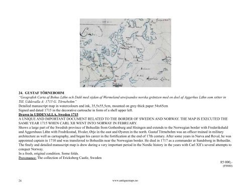
24. GUSTAF TÖRNEBOHM<br />
“Geografisk Carta af Bohus Lähn och Dahl med sijdan af Wermeland utwijsandes norska gräntzen med en deel af Aggerhus Lähn som stöter in<br />
Till. Uddevalla A: 1715 G. Törnebohm”<br />
Detailed manuscript map in watercolours and ink, 35,5x55,5cm, mounted on grey thick paper 54x65cm<br />
Signed and dated 1715 in the decorative cartouche in form of a shell upper left.<br />
Drawn in UDDEVALLA, Sweden 1715<br />
A UNIQUE AND <strong>IMPORTANT</strong> DOCUMENT RELATED TO THE BORDER OF SWEDEN AND NORWAY. THE MAP IS EXECUTED THE<br />
SAME YEAR 1715 WHEN CARL XII WENT INTO NORWAY IN FEBRUARY.<br />
Shows a large part of the Swedish province of Bohuslän from Gothenburg and Hisingen and extends to the Norwegian border with Frederikshald<br />
and Aggershuus Lähn with Fredriksstad, Hvaler, Ørje in the east and Øyeren in the north. Gustaf Törnebohm was an officer trained in military<br />
architecture as well as cartography, and began his career in the fortification at the end of 17th century. After some years in Narva and Reval, he was<br />
appointed captain in 1710 and was transferred to Bohuslän near the Norwegian border. He died in 1717 as a commander at Sundsborg in Bohuslän.<br />
The finely and detailed manuscript map is drew during a very important period in the Nordic history in the years with Carl XII’s several attempts to<br />
conquer Norway.<br />
In a fresh, original condition. Some folds.<br />
Provenance: The collection of Ericksberg Castle, Sweden<br />
85 000,-<br />
(€9880)<br />
24<br />
www.antiquemaps.no